Upper Muley Twist from Notom Rd?

Jammer

❤2Hike
.
Joined
Feb 23, 2012
Messages
659
Has anybody ever gone up and over the reef to Upper Muley Twist from Notom Rd?

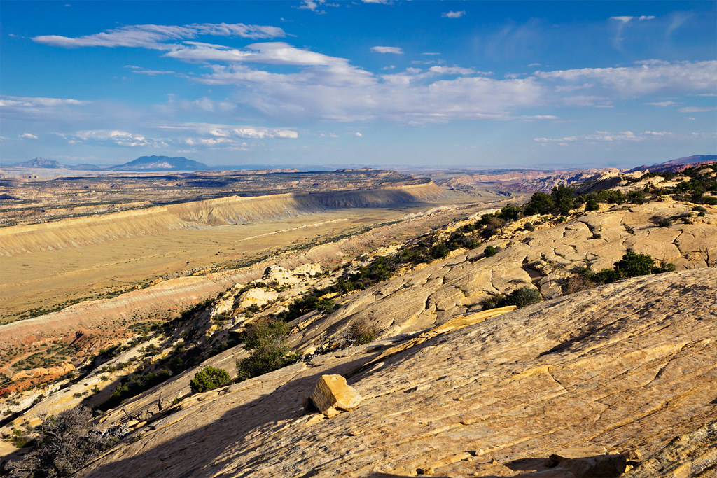
I'm looking at doing another long hike and thinking about connecting Upper Gulch to Tarantula Mesa and would love to find a way over the reef w/o going all the way down to the Burr Trail switchbacks and then walk back up Notom Rd.

My ideal crossing would be at the Strike Valley Overlook, but along the Rim Route in Upper Muley Twist could work too. When I was there last time it looked like it *might* be possible, especially at the northern end, but I really didn't explore too much. I've never been to Strike Valley Overlook, but via maps it looks steeper.

The route I'm looking for has to be big-pack friendly w/o any technical portions. A little bit of scrambling or pack lowering/lifting is ok.

Thanks for any insight.

- Jamal
 
Sheets Gulch pokes through from the scenic drive to the Notom Road. It is a bit further North than you are looking I think, but is an awesome awesome trail... I am very curious as to where this route you are looking for might materialize. I would think that intuitive cat may have some ideas.
 
The middle and southern portions of the rim route are certainly steeper, though I can't speak specifically for the Strike Valley Overlook. Even at the north end you'd probably spend a good amount of time searching for the right path. It would absolutely require some steep slickrock scrambling.

This is looking south from the rim near the northern end of the UMTC loop. It's probably around here that it would be possible.


South across the Strike Valley by ashergrey, on Flickr
 
Thanks, Nate -- I wasn't thinking about north of UMT, but that could be a possibility. Ideally I'd love to get down at Strike Valley Overlook because I hope to go up Bitter Creek Cyn which is directly opposite. BUT... it's all TBD.

- JG
 
Fly? I learned to do I-15 on auto-pilot many years ago! From that point east... I'll drink a lot of caffeine!

BUT... I'm not sure what my plans are. I'm actually itching to do St. George to Moab this year, but I can't decide if I want to do it this spring or maybe in the fall. I fear I won't be ready by mid-spring (planning, fitness and work), but I've never done a major hike in the fall and not sure exactly what to expect. Also not sure if I can wait THAT long! Maybe a series of shorter hikes might be the way to go.

Keep me posted if you guys think you might head down that way. The longer way around is only an additional 5 miles so it's not the end of the world, but it would be cool if there was a more exciting way over the reef and it would be comforting knowing in advance somebody else had done it!

Thanks,
- Jamal
 
Thanks, Nate -- I wasn't thinking about north of UMT, but that could be a possibility. Ideally I'd love to get down at Strike Valley Overlook because I hope to go up Bitter Creek Cyn which is directly opposite. BUT... it's all TBD.

- JG

it's possible to enter Upper Muley through the area known as the Onion Beds in the NE part of the Circle Cliffs. I think it is a bit tricky to find the route, but I know a few people who have entered the northern end of the UMT trail through the 'fins'. if you look at satellite images, there is a a spot or two that break through to the actual trail from the circle cliffs. in terms of getting down to the strike valley on the east side, i'm not sure.
I'l do a bit more asking around and see what i can come up with.
i also have enough free time before season starts that i can probably get out there and try to do some scouting myself.
 
The middle and southern portions of the rim route are certainly steeper, though I can't speak specifically for the Strike Valley Overlook. ....
This is looking south from the rim near the northern end of the UMTC loop. It's probably around here that it would be possible.


South across the Strike Valley by ashergrey, on Flickr

ashergrey, we are working out a route down to help Jammer with his quest. Can you identify the GPS coordinates for this shot and the one following from your trip report so we can go try to descend from there please?

Thanks, -Art
http://backcountrypost.com/forum/index.php?attachments/shadowed-jpg.7405/
Hmmm.... sometimes this direct link to your trip report third photo doesn't work properly. The "shadowed" one is the one I am asking about.
 
Unfortunately, I don't have exact geotags for any of my Upper Muley Twist shots. I can tell you that the quoted photo is from roughly 37.928916,-111.074774. That's with a +/- accuracy of about 100 yards. Pull that spot up on Google Earth and you can see the slope appears to be navigable, albeit with some zig-zagging and scrambling required.

The shadowed shot is from below the saddle at 37.922316,-111.070216. Compare with this screenshot from Google Earth and you can see the terrain matches.

Screen Shot 2013-03-03 at 3.52.56 PM.png

This would not be an ideal choice to ascend/descend the reef. My photo is deceiving because it's a stitch covering a roughly 210˚ field of view. The perspective diminishes the center of the frame, making the terrain there seem not as severe as in reality. Just to the south of that spot on the rim is a scramble with exposure that made me a little skittish when I did the hike solo.
 
it's possible to enter Upper Muley through the area known as the Onion Beds in the NE part of the Circle Cliffs. I think it is a bit tricky to find the route, but I know a few people who have ...

Yep, I covered the west side quite a bit a few years ago. Here's my report with a map from then:

Upper Muley Exploration

(pardon the weird pic sizes, I was experimenting with a new layout at the time.)

I hope to link this with a route down the fold to the east. Ideally at Strike Valley Overlook, but if not as far south on the Rim Route as possible. As I said early in the thread or in private, it's not a big deal if I have to walk the extra 5-6 miles down and around via the switchbacks, but if you guys can help me find a more adventurous route -- it would be awesome!

Thanks,
- JG
 

Don't like ads? Become a BCP Supporting Member and kiss them all goodbye. Click here for more info.

Back
Top