Uintas information???

elkaholic

Member
Joined
Oct 21, 2014
Messages
32
I have a question for some of you experienced Uinta Mountain People out there. I am looking for a trail that comes out of Naturalist basin on the east end of the basin and goes over to the pigeon milk springs area of the world but can’t find one on a map. I have looked on the USGS maps and don’t see one but they don’t seam to show everything. If anyone knows of a trail I would love to hear about it. I am planning on taking a dozen scouts up there and want to limit any backtracking on the same trails if possible.
 
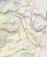
I've walked through there several times and I've never seen it (or heard about it). It could be a faint, unmarked thing and I just missed it though. Looks like it'd be pretty easy to just follow that bench from Evermann Lake southeast to link up to Pigeon Milk. If there is a trail, I'd imagine it would be right in there as the rest looks pretty rough, especially over that drop into the Duchesne drainage. I hate climbing in and out of that on the main trail.

upload_2015-4-23_9-26-6.png
 
Nick, I was thinking that the trail should be in that area as well. We are doing a loop and we wanted to go into naturalist basin but i didnt want to have to backtrack out the main trail on our way to 4 lakes basin. do you recall the nature of the terain? is there alot of fallen timber or is it fairly easy walking through there?

Aldaron, I was not aware of the 14 person limit. Thank you for bring that to my attention. iIf we end up having too many people we may have to split up
 
I'm sure there would be plenty of fallen timber and other off-trail roughness, but totally doable. Doing it with a bunch of scouts though, I'm not so sure. I guess just keep the group all really close for that section? Seems like every time I run into scouts on the trail, they're spread like a mile apart. That section is short enough that I wouldn't worry about it being too rough though.
 
i just mapped that area on google earth and it would cut almost three miles off the route. maybe i will present that to the boys and see if they are willing to crawl over a few logs to cut 3 miles off
 
. . . . see if they are willing to crawl over a few logs to cut 3 miles off
Be aware that it will much more than climbing over a few fallen logs. I took my kids on their first backpacking trip two years ago and we went just over a mile off trail trying to find a lake. We then concluded our trip going off trail to make a loop. It's slow going. With packs on you'll want to plan on at least double your normal rate. With a group of scouts I'd estimate that to be about a mile an hour. I also learned that the areas surrounding those ponds is typically kinda swampy. Depending on the mileage difference sometimes it's just faster to stay on trail. The biggest factor, I believe, is how dense is the woods?

Having said all that, going off trail is a great way for boys to get compass experience. Make sure you all know how to set a bearing and hold it. Have your topo handy to compare to what you're actually seeing. And as Nick said you'll have to work at keeping everyone together.

es mi dos pesos.
 
Ned has a good point there about it being a potentially good learning experience. And I agree, it can be really bad sometimes. But sometimes it's not at all. It's just hit and miss in my experience and the density of the forest hasn't always been the deciding factor. More often than not, I've had very few problems going off trail up there.
 
I elk hunt on the north slope and spend several weeks a year completely off trail so I am VERY familiar with the thickness of the woods. I am also familiar with the swamp factor of many of the meadows. With that said I have found it to be fairly easy walking along the tree lines of meadows where it is dry ground but not so thick that you cant see more than 20 yards through the trees. Looking at Google, it looks like we can skirt the side of meadows for all but about .6 miles going from Everman lake to Pigeon Milk Spring.One of my big goals with this trip is to teach these boys that they can do hard things and that hard things can be enjoyable. I think that a little off trail would be very good for them.

On a side note, I really want to hit Allen Lake and try my hand at some grayling but have noticed that there is no marked trail to that lake. Has anyone been there or have any advice for camping spots and access routes
 
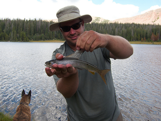
I spent a night at Allen Lake a few years ago. The Grayling were easy to catch. We came in from Cyclone Pass and then out west to the trail and back up to the Highline. There are definitely no trails around the lake itself. It's pretty typical off-trail terrain. Not too bad.

My trip report: http://backcountrypost.com/threads/four-lakes-basin-uintas.333/

6142090041_7e365694c0_z.jpg
 
Great Graylng Nick. Was there decent camping around the lake? What was working best for the Grayling? I haven't fished for them sense I was a scout hiking through that area.
 
Excellent camping and big grassy meadows on the west side of the lake. Probably good sites elsewhere but we didn't explore much. We came in about lower middle on the east side and went along the south shore before finding good spots over there.

I was catching them with a spin rod rigged up with a renegade and a bubble. My buddy was using a traditional fly rod but didn't have as much luck because they were rarely close to the shore. The casting distance with the bubble was critical. For much of the evening the lake was totally boiling though. It was really cool.

Map of my tracks:

View larger map.
 
I see you also stayed at Carolyn lake. I here there are grayling in there as well. did you have any lick there
 
We didn't fish Carolyn. Got there as it was getting dark and then packed up and headed out first thing in the morning.
 

Don't like ads? Become a BCP Supporting Member and kiss them all goodbye. Click here for more info.

Back
Top