Devin Ashby
Don't Bust The Crust!
- Joined
- Mar 4, 2016
- Messages
- 72
It's been a minute since i've shared a trip report here. But I relied pretty heavily on some information shared here in this forum to plan my trip, so I thought i'd share this as well.
I have no idea how many people have actually done this route the way I did it, but was surprised to see cairns on one of the passes that we used as a short cut. So maybe more people have done it than I thought at first.
I also hesitate just a touch to share too much detail, as going over passes with no established trail can be dangerous, much higher risk, and such. So take that for what it is, and know your own skill level.
My goal for this route was to connect a loop of basins that went from Middle Basin, into Naturalist, into Rock Creek and finally over and into Amethyst. So a nice big lolipop of adventure.
I had actually never been into middle basin before and dang, it's beautiful up in there. With Hayden, Agassiz and Spread Eagle Peaks above on all sides, it's pretty spectacular in there. But we worked our way over the pass and dropped into Naturalist. This was actually steeper and much more loose on the middle basin side than I expected it to be. But it wasn't as cruxy as it could have been.


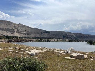
Once we got into Naturalist, we had a quick lunch because clouds were brewing, and we wanted to get over the next pass without any problems.
We took a shortcut that I had mapped from the planning I had done, hoping it would go, and it did. It was a bit easier than I expected it to be, and gave for some incredible views.

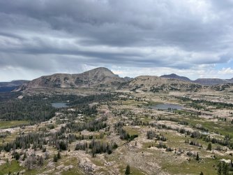

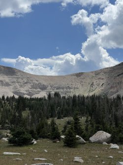
By this point we had dropped into Rock Creek Basin and made our way to one of the lakes on the Head of Rock Creek trail. It made for a 9ish mile day with about 2500' of gain.
We enjoyed a nice casual afternoon to relax from the miles and enjoy a really quiet and nice evening.
Now we were on day 3. This was the crux of the whole route for me personally, mostly from a mental standpoint. Dropping into Amethyst Lake from Rock Creek Basin. When you're at Amethyst lake and looking at the wall of rock to the south east, it's pretty elusive. But from research, I knew it had to go. So we made our way up in the morning through the amazing wildflowers. There was a very apparent goat, deer, sheep trail up through the brush, and soon enough we were on top of the pass. There was a large cairn up on top of the pass too. Maybe it's a route that people are using to summit Ostler from that side, rather than from the Ostler lake side? Anyway, it absolutely stunning up there and just a beautiful place to look down on the lake and Rock Creek on the other side.
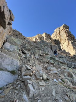
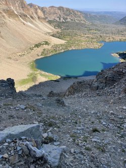
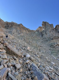
We found the obvious spot to drop down from the pass and start working our way down towards the lake. This was incredibly long, slow and taxing on the knees. It's steep, loose, and for the majority of the descent, I had 3 points of contact to keep stable. I would absolutely not want to scramble up this from the lake.
There's a significant amount of detail more that I could share. But this was an incredible trip and one I had been planning/dreaming of doing for a very long time... years.
Happy day!
I have no idea how many people have actually done this route the way I did it, but was surprised to see cairns on one of the passes that we used as a short cut. So maybe more people have done it than I thought at first.
I also hesitate just a touch to share too much detail, as going over passes with no established trail can be dangerous, much higher risk, and such. So take that for what it is, and know your own skill level.
My goal for this route was to connect a loop of basins that went from Middle Basin, into Naturalist, into Rock Creek and finally over and into Amethyst. So a nice big lolipop of adventure.
I had actually never been into middle basin before and dang, it's beautiful up in there. With Hayden, Agassiz and Spread Eagle Peaks above on all sides, it's pretty spectacular in there. But we worked our way over the pass and dropped into Naturalist. This was actually steeper and much more loose on the middle basin side than I expected it to be. But it wasn't as cruxy as it could have been.


Once we got into Naturalist, we had a quick lunch because clouds were brewing, and we wanted to get over the next pass without any problems.
We took a shortcut that I had mapped from the planning I had done, hoping it would go, and it did. It was a bit easier than I expected it to be, and gave for some incredible views.


By this point we had dropped into Rock Creek Basin and made our way to one of the lakes on the Head of Rock Creek trail. It made for a 9ish mile day with about 2500' of gain.
We enjoyed a nice casual afternoon to relax from the miles and enjoy a really quiet and nice evening.
Now we were on day 3. This was the crux of the whole route for me personally, mostly from a mental standpoint. Dropping into Amethyst Lake from Rock Creek Basin. When you're at Amethyst lake and looking at the wall of rock to the south east, it's pretty elusive. But from research, I knew it had to go. So we made our way up in the morning through the amazing wildflowers. There was a very apparent goat, deer, sheep trail up through the brush, and soon enough we were on top of the pass. There was a large cairn up on top of the pass too. Maybe it's a route that people are using to summit Ostler from that side, rather than from the Ostler lake side? Anyway, it absolutely stunning up there and just a beautiful place to look down on the lake and Rock Creek on the other side.


We found the obvious spot to drop down from the pass and start working our way down towards the lake. This was incredibly long, slow and taxing on the knees. It's steep, loose, and for the majority of the descent, I had 3 points of contact to keep stable. I would absolutely not want to scramble up this from the lake.
There's a significant amount of detail more that I could share. But this was an incredible trip and one I had been planning/dreaming of doing for a very long time... years.
Happy day!
