Uinta Highline Trail

JohnSkoolie

Member
Joined
Mar 7, 2023
Messages
17
So I'm planning on doing the whole trail starting 7/12

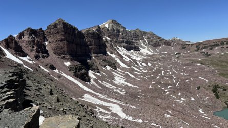
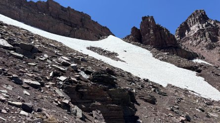
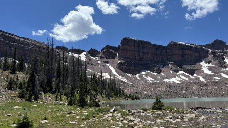
I want to do it in 8 days, which I think is pretty doable @ about 13 miles a day. I am going back and forth between starting at Leidy and doing 80mile skipping the dry section and doing the whole trail. I want to do the whole trail. I am going to call the forest service tomorrow and see what the conditions are like out there.

Anyone know anyone that has done the trail yet?
 
Dead Horse Pass will still be snow-covered. Ice axe and crampons mandatory.

If steep snow ain't your thing, wait til August.
 
Dead Horse Pass will still be snow-covered. Ice axe and crampons mandatory.

If steep snow ain't your thing, wait til August.
I seen videos of people doing it in July and I didn't see that. I don't want to get myself in a sticky situation... is there a way to verify that via satellite, rangers, other hikers when it gets closer to time? Thanks for the help
 
I seen videos of people doing it in July and I didn't see that. I don't want to get myself in a sticky situation... is there a way to verify that via satellite, rangers, other hikers when it gets closer to time? Thanks for the help
Check recent satellite imagery (most recent clear-sky run, from a week ago, had the pass 100% covered and the lake still frozen). Easiest way to access is via a Caltopo Pro subscription (I find Sentinel's earth explorer to be clunky and terrible). Plus you get the benefit of self-solving and building your skills!

Rangers won't be able to provide much help, as that area is infrequently patrolled. Trail crews will not be up there, given the lingering snow.

In a normal snow year, the 3rd week of July is the soonest I recommend tackling Dead Horse. And this is not a normal snow year.
 
Echoing what @LarryBoy said. Just because you seen some reports or videos or other info somewhere showing people having no trouble with Dead Horse in early July doesn't mean it's like that every year. There are years where you get well above average snowpack and years where you get well under average. This year was above average. Years where it's well below average, which we've had a few in the recent past, then yes, Dead Horse can be melted out by early July. But again, like Larry said, that's not the case this year. As for the east end, it's been reported that the few springs or other water sources out that way were all reliable last year and I don't think that'd change at all this year, because, again, the snowpack has been above average the last couple winters. And we are ever grateful for it.
 
Echoing what @LarryBoy said. Just because you seen some reports or videos or other info somewhere showing people having no trouble with Dead Horse in early July doesn't mean it's like that every year. There are years where you get well above average snowpack and years where you get well under average. This year was above average. Years where it's well below average, which we've had a few in the recent past, then yes, Dead Horse can be melted out by early July. But again, like Larry said, that's not the case this year. As for the east end, it's been reported that the few springs or other water sources out that way were all reliable last year and I don't think that'd change at all this year, because, again, the snowpack has been above average the last couple winters. And we are ever grateful for it.

I'm totally cool with doing some snow travel, I just have to plan to start at Leidy instead. Looking at the satellite image attached to this post, It seems to have about a half mile of dark ground. Using a caltopo map for UHT, DHP point on the trail is to the left of the measure I took. The smaller sections of brown path is around 900-1000ft. Thanks @fossana for the link. I guess I'll just play it by ear as time goes on. Hopefully I can get in touch with someone who treks it before I go and get some beta. Thanks yall for helping.
 

Attachments

  • Screenshot 2024-07-01 212257.png
    Screenshot 2024-07-01 212257.png
    259.6 KB · Views: 7
Caltopo Sentinel from 6-23-24, the most recent one I saw without too many clouds to see anything.

deadhorse6-23-24.jpg
 
@b.stark @LarryBoy

Thanks for the update B.Stark! I should really look into getting the upgraded version of caltopo. If that picture is from a week ago then I'm not too worried because I'm going east to west, so I won't be there until like the 18th-19th. Thanks everyone for the help.
 
@b.stark @LarryBoy

Thanks for the update B.Stark! I should really look into getting the upgraded version of caltopo. If that picture is from a week ago then I'm not too worried because I'm going east to west, so I won't be there until like the 18th-19th. Thanks everyone for the help.
Just keep an eye on it. We've got a really hot spell forecasted all this week that could really help speed up some melting up there for you. But be prepared to have at least some spikes and an ice axe on hand just in case.
 
The most recent pass from 7/5 looks like there's been significant melt. Since you're not hitting it for another week it should be doable, but I'd expect a couple of small snow patches remaining that combine with the loose surface to make it slightly "spicy".

1720556903814.png
 
The most recent pass from 7/5 looks like there's been significant melt. Since you're not hitting it for another week it should be doable, but I'd expect a couple of small snow patches remaining that combine with the loose surface to make it slightly "spicy".

View attachment 132657
@WasatchWill

With this being Jul 5th and the heat wave that hit the west, I'm feeling pretty good. I've done a lot of snow travel before so it's nothing new. Also judging by the photo, it definitely looks like I'll be able to navigate around a lot of it. I'm in contact with someone who just finished trail. I'm gonna ask them about DHP and the snow. Will post an update.
 
@alltrac @WasatchWill

I just talked with someone that finished trail a few days ago. I asked the about DHP:

"It’s easily to get around. It might be mostly gone by the time you get there. It’s still freezing at night up there tho. This heat wave not having much of an impact on the high Uintas I believe. There’s a climbers trail that skirts around the snow. It’s not a big deal at all and doesn’t warrant micro spikes."

I feel good about it all now that I talked with someone. On such a long trek, I don't want to bring gear I won't use because the weight is going to be a big one.
Yeah...I'd agree you'll be good to go now. I think @Parma just did it this last week and maybe he was or is part of the group of whoever you spoke with. He did it eastward this time though and sounds like he wouldn't have wanted to climb it going westward in its current condition. However, my experience with it with no snow, I'd rather climb it going westward rather than descend it eastward or northward down to Dead Horse Lake. The initial descent down from the ridge and trying to maintain footing for the first few hundred feet was a bit spicy feeling for me when I was solo.
 
I was just on DHP on Tuesday 7/9. We were indeed going eastbound. Here are some photos of it.
We opted to avoid the snow going down, it was very sketchy. We followed some deer that made a nice path to the trail below the snow. Other areas with snow was easier to avoid since there were larger rocks to walk on. It's that steep/loose dirt that was not fun.
 

Attachments

  • IMG_9196.jpg
    IMG_9196.jpg
    473.1 KB · Views: 12
  • IMG_9199.jpg
    IMG_9199.jpg
    504.7 KB · Views: 12
  • IMG_9200.jpg
    IMG_9200.jpg
    424.5 KB · Views: 12
I was just on DHP on Tuesday 7/9. We were indeed going eastbound. Here are some photos of it.
We opted to avoid the snow going down, it was very sketchy. We followed some deer that made a nice path to the trail below the snow. Other areas with snow was easier to avoid since there were larger rocks to walk on. It's that steep/loose dirt that was not fun.
Any intel on Rock Creek Basin? I’m going through there this weekend/early the following week and passed through in 2022. In ‘22 I took the northern route through the basin but it was still rough due to the sandy post-burn areas. I’m considering just going through the main Highline route through the center of the basin.
 
Hopefully you have some GPS tracks to follow, the trail is very tough to follow in that area and a lot of fallen trees over the trail. We went around via Lightning and Helen Lakes
 
Alltrac, I'd be interested in hearing how the "up the middle" approach through Rock Creek Basin worked out for you. I'll be there at the end of August, hopefully. I've been assuming from what I've read that the northern bypass (Head of Rock Creek Trail, Lightning/Helen Lakes) was still the best move. Any thoughts out there?
 
Hey - so I realized that the route we took in 2022 was the via Jack and Jill Lakes route, which was kind of awful. On the 22nd I ran into 3 guys going eastbound on my way out who had just gone through that way and it still sounds awful. I'm pretty sure that the 'through the middle of the basin' route is still really a bad time.

Based on this thread I opted to pick the northern route via Lightning Lake. At LL I noticed a lot of stock tracks going south so I took that rather than going up the ledge and around the NW part of the basin. It was fairly doable with only a couple of spots where I had to re-sync with the trail - some burn sections but not nearly as bad.

I went from Henrys Fork over Gunsight and then then westbound on the rest of the Highline on my way out - it might be my imagination but Yellowstone and Oweep basins seemed to have more/better carins than I remembered - much easier to traverse.

1722464987263.png
 
Cool. We'll avoid the temptation to go straight through, and take the north/northwest loop - or your variation thereof.
 
Back
Top