- Joined
- May 24, 2015
- Messages
- 179
The Trinity Alps are a great wilderness area located in Northern California between the Sierra and the Cascades. There are generally no trail quotas and also no advanced reservations available. Permits are required, but you pick them up on site, before hiking. We had a week available in August to hike and camp, in the Northern part of the state. The plan was to backpack, in trinity, whatever area that was not impacted by fires or smoke . Our backup plan was going to be to drive to the coast and hike or car camp, along some of the Lost Coast area. When we arrived in mid August, to Weaverville, there were no threatening fires nearby and there was minimal smoke in the air. We chose the Stuart Fork trail for a starter hike, with possible plans to hike up another canyon after that.
The weather was clear and warm with the usual possibility of local afternoon thunderstorms.

Our destination was 8 miles in, at Morris Meadow, where we would set up camp and then day hike to the upper lakes the next day. The trail was mostly forested which helped to keep us from overheating.

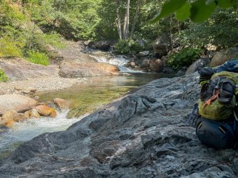
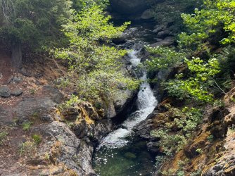
Lots of fun little creeks were coming into the trail from the steep hillsides.

The Stuart Fork trail is known for its gradual gradient up into the canyon. Russ enjoying a nice lunch stop along the way.

We found a well forested campsite just beyond Morris Meadow. We couldn't see any other campers nearby. It was midweek.

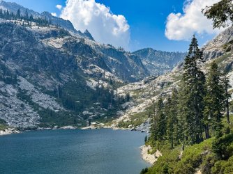
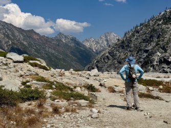
The next morning our day hike gave us the first views of the alps.


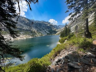
Soon we were at the granite bowl of Emerald Lake. Elevation 5,500 ft. It was really beautiful.

We hiked around the right side to get to the next basin.

Looking back down the canyon.

At the crest between the two lakes.

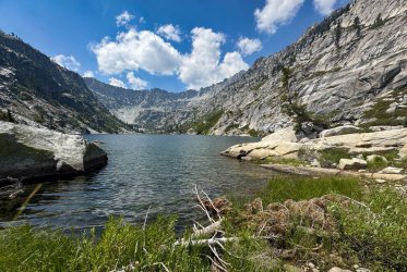
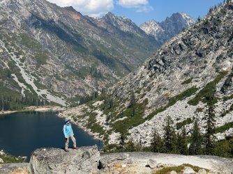
At 5,582 ft, Sapphire Lake was a great place to stop, eat lunch, do some fishing and take some pictures.

Sawtoothed ridgeline above Sapphire Lake

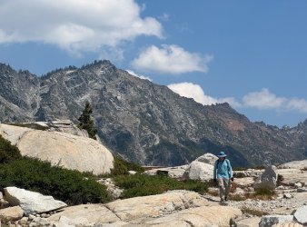
We turned around at Sapphire lake. There were great views on the way back down to Emerald Lake.

On the way back to our campsite there were a number of side creeks keeping the trail cool and noisy.

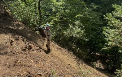
Back at camp we noticed some gathering clouds. The next morning, the clouds were still present and were starting to look threatening. We were scheduled to hike out that morning, so a change in the weather was not going to affect our plans for the day. The darker skies and some fallen leaves made the mood of the trail different as we passed thru some burn areas.

When we were more than half way to the parking lot it started to storm. First rain, than distant thunder, then close thunder, followed by intense hail stones. It was the most exciting part of the trip. We had plenty of time to gear up for the wetness, so we were able to keep hiking and just enjoy the change in weather.

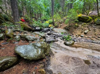
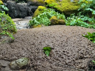
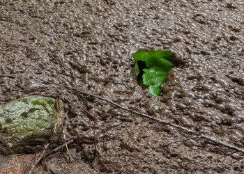
The thunder and hail continued on and off, for the remainder of the hike to the parking lot. Along the way, the small streams were getting swollen with the runoff, but still passable without much problem. What we stumbled onto next was something I had never seen in the back country. One of the side streams was not clear, like the others had been. It was a deep mocha brown colored, full of silt, from somewhere up above. The churning of the falling water, combined with the suspended silt, created just the right conditions for a lot of foam to develop. Not just the regular white foam that you see in eddy swirls. This was a large sustained mass of brown foam, that piled up on itself in a heaving blob. Almost two feet high in one pool.


Twenty inches of the foam formed on a pool upstream then got carried slowly over a small falls downstream.

This video shows the brown blob heaving and undulating with the water flowing underneath it. It's alive!!
I was so fascinated by this phenomenon that I had to do a little research, before posting about it. Evidently, bubbles on any natural flowing water will occur if there is enough biomaterial to be suspended in the water. Decaying leaves usually do the trick. The suspended material in the water will lower the surface tension of the water, allowing bubbles to form and persist, in turbulent areas. Silt can also cause the same effect and I am pretty sure that is what Russ and I witnessed. The creek was probably passing thru a recent burn area upstream or perhaps there was a small slide upstream. None of the other creeks we saw had this color to them and none of them had this much foam. It was such a special, temporary event. If it had started raining ( which it did later) the foam would have been popped by the falling drops. I was really glad we had decided to keep hiking thru the hail and did not rush to the car or hunker down on the trail....we would have missed it.
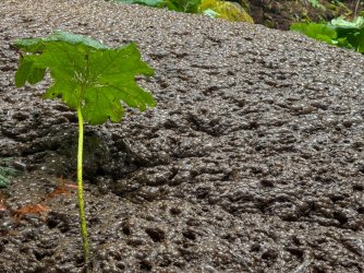
Interesting eye level lichen on the hike out.

Well planned spider web in an curvy knot of wood.

When we arrived at the car we got pelted again by some intense hail. Not wanting to open the car during the downpour we had to wait under a redwood tree only steps away, for ten minutes, until the micro storm lightened up. Once in the car, we checked the weather forecast and saw that the mountains would be blanketed in storms for a few days. We made the executive decision to head to the coast and car camp along the drier coast for the remaining part of our vacation. This next part of the report covers our travels along the Northern California coastline, camping at Redwood forests and hiking along the beaches.
A Banana slug greeted us at our redwood forest campsite.

Drying out from the mountain hailstorm.

The next day the weather was amazing. We were expecting fog and mist but were greeted with sunny skies and no wind. This is wedding rock in the Sue-meg state park. They have made a small alter area,near the top, for people to get married with a great ocean view backdrop.

There were parts of the coastal views that reminded me of Maui! The color of the water and the blooming flowers in the sun looked tropical.

A beach trail provided access to some tide pools. There were some different colored Sea Stars on the rocks.

This one was doing some gymnastics.

We drove south and found another campsite near some more coastline we wanted to explore.
There was a lot of redwood forests along the coast. It didn't take long to find an available campsite with redwoods all around us, for the next night. This site had an Artist Conk, fungus growing right over us.

I had to look up this organism online to get the proper name for it. Artist Conks have a hard rubbery texture.

The next day we hiked more scenic, mostly empty, coastline in clear weather.

Driftwood, or more like Drift Stump.

Little sea arch.

Near the Point Arena lighthouse we found some great views.


Hiking down to the waves we found a neat looking type of kelp, that does not grow on the Southern part of the California coastline. It is called Sea Palm. It has a strong holdfast foot that anchors itself to rocks in the tidal zone. There is a tall stalk growing upwards that elevates the top fronds into the sunlight. It looks much like a palm tree and thrives in the harsh conditions of tidal zone.

This video shows a healthy colony of the palms. They really have adapted to the constant current that was occurring in this four way intersection of coastal sea water.
We finished off our car camping with an interesting sunset. I don't know how this extra image of the sun showed up in this photo. I only noticed it when I got home. I don't think it was an internal camera reflection. If anyone has any ideas let me know.

Here it is cropped up, later in the sunset. Probably a reflection off the thin layer of clouds. Or mayber there was a huge mirror on that little island.

Tim V.
The weather was clear and warm with the usual possibility of local afternoon thunderstorms.
Our destination was 8 miles in, at Morris Meadow, where we would set up camp and then day hike to the upper lakes the next day. The trail was mostly forested which helped to keep us from overheating.
Lots of fun little creeks were coming into the trail from the steep hillsides.
The Stuart Fork trail is known for its gradual gradient up into the canyon. Russ enjoying a nice lunch stop along the way.
We found a well forested campsite just beyond Morris Meadow. We couldn't see any other campers nearby. It was midweek.
The next morning our day hike gave us the first views of the alps.
Soon we were at the granite bowl of Emerald Lake. Elevation 5,500 ft. It was really beautiful.
We hiked around the right side to get to the next basin.
Looking back down the canyon.
At the crest between the two lakes.
At 5,582 ft, Sapphire Lake was a great place to stop, eat lunch, do some fishing and take some pictures.
Sawtoothed ridgeline above Sapphire Lake
We turned around at Sapphire lake. There were great views on the way back down to Emerald Lake.
On the way back to our campsite there were a number of side creeks keeping the trail cool and noisy.
Back at camp we noticed some gathering clouds. The next morning, the clouds were still present and were starting to look threatening. We were scheduled to hike out that morning, so a change in the weather was not going to affect our plans for the day. The darker skies and some fallen leaves made the mood of the trail different as we passed thru some burn areas.
When we were more than half way to the parking lot it started to storm. First rain, than distant thunder, then close thunder, followed by intense hail stones. It was the most exciting part of the trip. We had plenty of time to gear up for the wetness, so we were able to keep hiking and just enjoy the change in weather.
The thunder and hail continued on and off, for the remainder of the hike to the parking lot. Along the way, the small streams were getting swollen with the runoff, but still passable without much problem. What we stumbled onto next was something I had never seen in the back country. One of the side streams was not clear, like the others had been. It was a deep mocha brown colored, full of silt, from somewhere up above. The churning of the falling water, combined with the suspended silt, created just the right conditions for a lot of foam to develop. Not just the regular white foam that you see in eddy swirls. This was a large sustained mass of brown foam, that piled up on itself in a heaving blob. Almost two feet high in one pool.
Twenty inches of the foam formed on a pool upstream then got carried slowly over a small falls downstream.
This video shows the brown blob heaving and undulating with the water flowing underneath it. It's alive!!
I was so fascinated by this phenomenon that I had to do a little research, before posting about it. Evidently, bubbles on any natural flowing water will occur if there is enough biomaterial to be suspended in the water. Decaying leaves usually do the trick. The suspended material in the water will lower the surface tension of the water, allowing bubbles to form and persist, in turbulent areas. Silt can also cause the same effect and I am pretty sure that is what Russ and I witnessed. The creek was probably passing thru a recent burn area upstream or perhaps there was a small slide upstream. None of the other creeks we saw had this color to them and none of them had this much foam. It was such a special, temporary event. If it had started raining ( which it did later) the foam would have been popped by the falling drops. I was really glad we had decided to keep hiking thru the hail and did not rush to the car or hunker down on the trail....we would have missed it.
Interesting eye level lichen on the hike out.
Well planned spider web in an curvy knot of wood.
When we arrived at the car we got pelted again by some intense hail. Not wanting to open the car during the downpour we had to wait under a redwood tree only steps away, for ten minutes, until the micro storm lightened up. Once in the car, we checked the weather forecast and saw that the mountains would be blanketed in storms for a few days. We made the executive decision to head to the coast and car camp along the drier coast for the remaining part of our vacation. This next part of the report covers our travels along the Northern California coastline, camping at Redwood forests and hiking along the beaches.
A Banana slug greeted us at our redwood forest campsite.
Drying out from the mountain hailstorm.
The next day the weather was amazing. We were expecting fog and mist but were greeted with sunny skies and no wind. This is wedding rock in the Sue-meg state park. They have made a small alter area,near the top, for people to get married with a great ocean view backdrop.
There were parts of the coastal views that reminded me of Maui! The color of the water and the blooming flowers in the sun looked tropical.
A beach trail provided access to some tide pools. There were some different colored Sea Stars on the rocks.
This one was doing some gymnastics.
We drove south and found another campsite near some more coastline we wanted to explore.
There was a lot of redwood forests along the coast. It didn't take long to find an available campsite with redwoods all around us, for the next night. This site had an Artist Conk, fungus growing right over us.
I had to look up this organism online to get the proper name for it. Artist Conks have a hard rubbery texture.
The next day we hiked more scenic, mostly empty, coastline in clear weather.
Driftwood, or more like Drift Stump.
Little sea arch.
Near the Point Arena lighthouse we found some great views.
Hiking down to the waves we found a neat looking type of kelp, that does not grow on the Southern part of the California coastline. It is called Sea Palm. It has a strong holdfast foot that anchors itself to rocks in the tidal zone. There is a tall stalk growing upwards that elevates the top fronds into the sunlight. It looks much like a palm tree and thrives in the harsh conditions of tidal zone.
This video shows a healthy colony of the palms. They really have adapted to the constant current that was occurring in this four way intersection of coastal sea water.
We finished off our car camping with an interesting sunset. I don't know how this extra image of the sun showed up in this photo. I only noticed it when I got home. I don't think it was an internal camera reflection. If anyone has any ideas let me know.
Here it is cropped up, later in the sunset. Probably a reflection off the thin layer of clouds. Or mayber there was a huge mirror on that little island.
Tim V.
Attachments
-
 IMG_6765.jpg613.7 KB · Views: 2
 -
 IMG_6780.jpg605.5 KB · Views: 1
 -
 IMG_6785.jpg606.3 KB · Views: 0
 -
 IMG_6791.jpg498.7 KB · Views: 0
 -
 IMG_6793.jpg599.6 KB · Views: 0
 -
 IMG_6800.jpg671.9 KB · Views: 0
 -
 IMG_6779.jpg684.7 KB · Views: 0
 -
 IMG_6808.jpg726.2 KB · Views: 0
 -
 IMG_6809.jpg732.4 KB · Views: 0
 -
 IMG_6816.jpg830.2 KB · Views: 0
 -
 IMG_6817.jpg808.2 KB · Views: 0
 -
 IMG_6820.jpg800.9 KB · Views: 0
 -
 IMG_6821.jpg763.8 KB · Views: 0
 -
 IMG_6823.jpg707.6 KB · Views: 0
Last edited:
")