RyanP
Member
- Joined
- Mar 1, 2015
- Messages
- 706
My wife and daughters were at a girls' camp this past week, so I decided to take my son Caleb backpacking for a local 3-night trip while they were out of town. This was our first backpacking trip of the year. I came up with the exact itinerary just a few days beforehand, thanks to a conversation with my friend Aaron that inspired the middle (and best) portion of the route. This ended up being a superb trip that covered a lot of the highlights of the southern Gores--our route took us over several high passes, peaks, and past spectacular lakes, traversing through numerous basins filled with wildflowers at their peak. I predicted before the trip that we would see more mountain goats than people over the first 2.5 days, and that held true (22 to 11). We alternated between on-trail and off-trail sections (about half our hiking time was off-trail), ending with a fun bike ride (over 2k ft of descent on a bike-only trail) to return to our car. Every day was challenging but none of the days were brutal, and none of them were too long so we got to camp fairly early every day. We both agreed it was one of our best trips ever.
Day 1:
We drove the 1.5 hours from home to Vail Pass and stashed a couple of old bikes behind some trees up the hill from the parking lot (to be used at the end of the trip). We then drove 10-15 minutes down the highway to our starting point and headed up the steep trail:

The trail was never too rough or steep, but it was a relentless uphill slog for the first couple of miles. At least the views of the valley were nice:
After a few miles, the trail flattened out somewhat and we started to see more flowers and peaks:

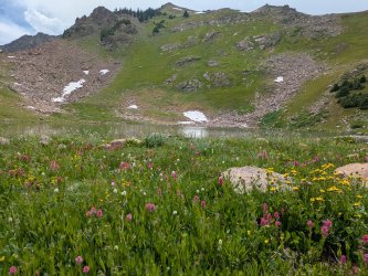
The hike up to the lake is less than 5 miles, but with around 3.5k ft of gain, so my legs were tired when we got there even though it was early in the day. There is an old cabin at the lake that appeared to be in surprisingly decent shape, so we decided to sleep there.

The photos don't capture how spectacular and special this basin is. We were lucky to have it all to ourselves (it helps that it was a Wednesday--but on our hike up, we passed two pairs of backpackers leaving the basin who had stayed there the previous night). Sadly the air quality was poor so we could barely make out the big peaks (Mt of the Holy Cross, etc) in the distance.
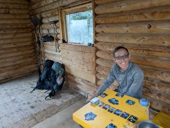
The weather forecast was pretty bad last week, so we started relatively early each day (since CO thunderstorms typically occur in the afternoons) and we arrived at the lake early in the afternoon. I even packed a card game (something I never do!) in case we experienced extended time in the tent. It started to rain, so we enjoyed a few games in the cabin (3-1 score in favor of Dad, but who's counting--I swear I didn't bring this up constantly throughout the rest of the trip). It was so cozy that I hoped it would rain hard for hours. It only rained for a few minutes though, and throughout the rest of the trip we got very little rain.

We enjoyed a magical evening by the lake as we ate dinner.


Day 2:
In the morning a couple of mountain goats came to visit our cabin:

These two fought over who got to lick the rock I had peed on during the night (that's what mountain goats do), and to our surprise, the little one on the left won.

We headed up to the pass above the lake. The first section of the slope was a tedious boulder field. The rocks were stable and for the most part weren't too large or too small, so it wasn't too bad, but we still made slow progress. The goats decided to follow us and quickly passed us up.

We eventually got to the large grass patch we were aiming for, and instantly stumbled upon a fairly decent use trail that wasn't visible from below.

The pass wasn't nearly as hard as it looked to be from the lake.

Our goat friend was waiting for us at the pass ("what took you so long?"):

The three of us scrambled up the peak right off the pass.

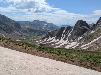
The views were superb from the summit:

As we headed down the pass, more mountain goats showed up. One of the highlights of the trip for me was seeing a baby goat running around and hearing it bleating on top of the pass.


A marmot kindly posed for me down below the lake:

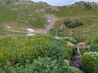
The next stretch was heavenly off-trail travel, with easy terrain and tons of wildflowers:

We made our way down to a relatively popular lake, where we saw another backpacker. I really wanted to go for a swim but it was too cool. We had nice cool temps throughout the trip (the chocolate in my hip-belt pocket never melted!), which is mostly nice but I missed the daily swims.

In the Gores, it's not uncommon to see mountain goat fur on branches:

We took the trail for a mile or so

We left the trail and aimed cross-country toward a set of ponds where we planned to camp. Most of this section was unremarkable walking through the woods, but there were some beautiful moments along the way:


Below-treeline off-trail travel can be brutal in the Gore range, but this area wasn't too bad at all. Before long we arrived at our destination:

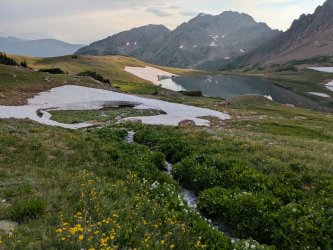
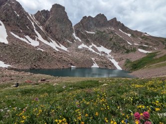
What a spectacular and pristine area. No trails, fire rings, established campsites, or any other signs of humans. There were a couple of super nice, flat spots that made for perfect campsites as well. We explored around the ponds and admired the surrounding peaks:


Day 3:
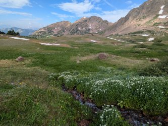
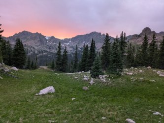
We unfortunately didn't have time to linger in camp properly the next morning (we had a bunch of above-treeline hiking to do before the afternoon thunderstorms rolled in), but I managed to snap a few quick photos of the spectacular morning in paradise:


We headed up the valley and it remained equally amazing as we approached the obvious grass ramp that would take us up to the next peak (this photo is looking back).

The "grass ramp" was actually a mix of grass, rocks, and wildflowers. It was steep and I was glad that I was going up it instead of down, but otherwise it wasn't too bad.

The views looking back from the ramp continued to improve:


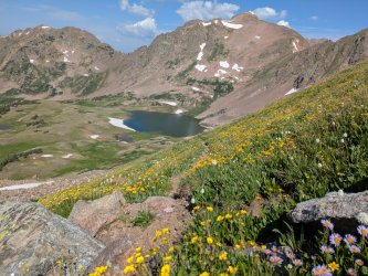
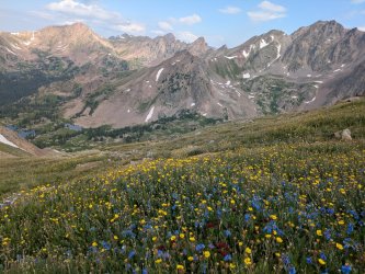
Eventually it became less steep as we made our way up closer to the standard ridge approach for the peak. This is my favorite photo from the trip; I love how it shows many of the places we visited the previous day:

The views from the peak were grand, despite the hazy conditions:


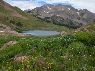
We then headed down the ridge that most people use to climb this mountain. Our next destination was the two small ponds to the left of the below photo, and then the pass beyond them:

We somehow got off route on the ridge and started going down a bad section of talus and scree. This was supposed to be an easy part of the hike, but it ended up being the trickiest/sketchiest part of the entire trip! I suppose it taught us a lesson that we shouldn't get careless and stop paying attention. At least the scenery was spectacular. Once we got to the bottom of the nasty slope, the terrain was heavenly as we traversed over to the pass. It started raining and hailing, so we ducked for cover under a patch of trees for 20 minutes or so until it stopped and the sun came out again (typically CO weather!).

We made our way down from the pass and toward the lake. I was excited that the sun was out so I could finally take a proper swim.


This area reminded me of the Maroon Bells-Snowmass Wilderness.

We soon got to the next pass:


The trail continued to be gradual and easy. We took it a mile or so, and then wandered off the trail a bit to find a place to camp.


We found a cozy, quiet campsite a ways off the trail and ate an early dinner.


Day 4:
The trail for the next handful of miles was pretty uneventful as it dropped in elevation through the forest and then gained the elevation again. We started to see people since we were on trail and it was a Saturday. We were glad we camped where we did the last night because there didn't seem to be many good campsites along this stretch of trail. This trip confirmed my opinion that the Eagles Nest Wilderness reveals its full glory only if you get up above and beyond where its trails take you; the trails are surprisingly busy when I've been there but aren't really destination-worthy (at least compared to many of the other classic CO backpacking areas) in my opinion. The forested section still had its moments though:

Eventually we broke treeline and the views steadily improved as we followed the trail to the pass.


We climbed the peak on the right side of the pass, and followed the broad ridge to a higher peak (left of center in the photo below), where a new trail would take us back to Vail Pass and our bikes.

This is looking back from the ridge. The trail took us to the pass on the left side of the photo below, and we climbed the peak left of center, then followed the glorious easy ridge. We enjoyed the views toward Copper Mountain (in the top center of the photo), which is where we're planning on skiing next winter.

Heading down the trail from the high peak on the ridge, the views were amazing towards the heart of the Gore range in the distance.


I was grateful that the trail down to Vail Pass was nice and gradual for most of the way. The top half of the trail was especially scenic.


We swapped our packs for our bikes, and rode down the paved bike path to our starting trailhead.


Approaching our starting trailhead...

What a fun way to end the trip! Biking downhill is way more fun than hiking downhill! I'm grateful to live so close to such beautiful country, and cherish these trips that I get to do with Caleb.
Day 1:
We drove the 1.5 hours from home to Vail Pass and stashed a couple of old bikes behind some trees up the hill from the parking lot (to be used at the end of the trip). We then drove 10-15 minutes down the highway to our starting point and headed up the steep trail:
The trail was never too rough or steep, but it was a relentless uphill slog for the first couple of miles. At least the views of the valley were nice:
After a few miles, the trail flattened out somewhat and we started to see more flowers and peaks:
The hike up to the lake is less than 5 miles, but with around 3.5k ft of gain, so my legs were tired when we got there even though it was early in the day. There is an old cabin at the lake that appeared to be in surprisingly decent shape, so we decided to sleep there.
The photos don't capture how spectacular and special this basin is. We were lucky to have it all to ourselves (it helps that it was a Wednesday--but on our hike up, we passed two pairs of backpackers leaving the basin who had stayed there the previous night). Sadly the air quality was poor so we could barely make out the big peaks (Mt of the Holy Cross, etc) in the distance.
The weather forecast was pretty bad last week, so we started relatively early each day (since CO thunderstorms typically occur in the afternoons) and we arrived at the lake early in the afternoon. I even packed a card game (something I never do!) in case we experienced extended time in the tent. It started to rain, so we enjoyed a few games in the cabin (3-1 score in favor of Dad, but who's counting--I swear I didn't bring this up constantly throughout the rest of the trip). It was so cozy that I hoped it would rain hard for hours. It only rained for a few minutes though, and throughout the rest of the trip we got very little rain.
We enjoyed a magical evening by the lake as we ate dinner.
Day 2:
In the morning a couple of mountain goats came to visit our cabin:
These two fought over who got to lick the rock I had peed on during the night (that's what mountain goats do), and to our surprise, the little one on the left won.
We headed up to the pass above the lake. The first section of the slope was a tedious boulder field. The rocks were stable and for the most part weren't too large or too small, so it wasn't too bad, but we still made slow progress. The goats decided to follow us and quickly passed us up.
We eventually got to the large grass patch we were aiming for, and instantly stumbled upon a fairly decent use trail that wasn't visible from below.
The pass wasn't nearly as hard as it looked to be from the lake.
Our goat friend was waiting for us at the pass ("what took you so long?"):
The three of us scrambled up the peak right off the pass.
The views were superb from the summit:
As we headed down the pass, more mountain goats showed up. One of the highlights of the trip for me was seeing a baby goat running around and hearing it bleating on top of the pass.
A marmot kindly posed for me down below the lake:
The next stretch was heavenly off-trail travel, with easy terrain and tons of wildflowers:
We made our way down to a relatively popular lake, where we saw another backpacker. I really wanted to go for a swim but it was too cool. We had nice cool temps throughout the trip (the chocolate in my hip-belt pocket never melted!), which is mostly nice but I missed the daily swims.
In the Gores, it's not uncommon to see mountain goat fur on branches:
We took the trail for a mile or so
We left the trail and aimed cross-country toward a set of ponds where we planned to camp. Most of this section was unremarkable walking through the woods, but there were some beautiful moments along the way:
Below-treeline off-trail travel can be brutal in the Gore range, but this area wasn't too bad at all. Before long we arrived at our destination:
What a spectacular and pristine area. No trails, fire rings, established campsites, or any other signs of humans. There were a couple of super nice, flat spots that made for perfect campsites as well. We explored around the ponds and admired the surrounding peaks:
Day 3:
We unfortunately didn't have time to linger in camp properly the next morning (we had a bunch of above-treeline hiking to do before the afternoon thunderstorms rolled in), but I managed to snap a few quick photos of the spectacular morning in paradise:
We headed up the valley and it remained equally amazing as we approached the obvious grass ramp that would take us up to the next peak (this photo is looking back).
The "grass ramp" was actually a mix of grass, rocks, and wildflowers. It was steep and I was glad that I was going up it instead of down, but otherwise it wasn't too bad.
The views looking back from the ramp continued to improve:
Eventually it became less steep as we made our way up closer to the standard ridge approach for the peak. This is my favorite photo from the trip; I love how it shows many of the places we visited the previous day:
The views from the peak were grand, despite the hazy conditions:
We then headed down the ridge that most people use to climb this mountain. Our next destination was the two small ponds to the left of the below photo, and then the pass beyond them:
We somehow got off route on the ridge and started going down a bad section of talus and scree. This was supposed to be an easy part of the hike, but it ended up being the trickiest/sketchiest part of the entire trip! I suppose it taught us a lesson that we shouldn't get careless and stop paying attention. At least the scenery was spectacular. Once we got to the bottom of the nasty slope, the terrain was heavenly as we traversed over to the pass. It started raining and hailing, so we ducked for cover under a patch of trees for 20 minutes or so until it stopped and the sun came out again (typically CO weather!).
We made our way down from the pass and toward the lake. I was excited that the sun was out so I could finally take a proper swim.
This area reminded me of the Maroon Bells-Snowmass Wilderness.
We soon got to the next pass:
The trail continued to be gradual and easy. We took it a mile or so, and then wandered off the trail a bit to find a place to camp.
We found a cozy, quiet campsite a ways off the trail and ate an early dinner.
Day 4:
The trail for the next handful of miles was pretty uneventful as it dropped in elevation through the forest and then gained the elevation again. We started to see people since we were on trail and it was a Saturday. We were glad we camped where we did the last night because there didn't seem to be many good campsites along this stretch of trail. This trip confirmed my opinion that the Eagles Nest Wilderness reveals its full glory only if you get up above and beyond where its trails take you; the trails are surprisingly busy when I've been there but aren't really destination-worthy (at least compared to many of the other classic CO backpacking areas) in my opinion. The forested section still had its moments though:
Eventually we broke treeline and the views steadily improved as we followed the trail to the pass.
We climbed the peak on the right side of the pass, and followed the broad ridge to a higher peak (left of center in the photo below), where a new trail would take us back to Vail Pass and our bikes.
This is looking back from the ridge. The trail took us to the pass on the left side of the photo below, and we climbed the peak left of center, then followed the glorious easy ridge. We enjoyed the views toward Copper Mountain (in the top center of the photo), which is where we're planning on skiing next winter.
Heading down the trail from the high peak on the ridge, the views were amazing towards the heart of the Gore range in the distance.
I was grateful that the trail down to Vail Pass was nice and gradual for most of the way. The top half of the trail was especially scenic.
We swapped our packs for our bikes, and rode down the paved bike path to our starting trailhead.
Approaching our starting trailhead...
What a fun way to end the trip! Biking downhill is way more fun than hiking downhill! I'm grateful to live so close to such beautiful country, and cherish these trips that I get to do with Caleb.
Attachments
-
 PXL_20250716_224125054.jpg495.5 KB · Views: 3
 -
 PXL_20250717_011149131.jpg511.4 KB · Views: 4
 -
 PXL_20250717_152251139.jpg561.7 KB · Views: 2
 -
 PXL_20250717_162216130.jpg606.1 KB · Views: 2
 -
 PXL_20250717_165118469.jpg476.9 KB · Views: 2
 -
 PXL_20250717_192108779.jpg613.3 KB · Views: 1
 -
 PXL_20250718_022138373.jpg444.9 KB · Views: 2
 -
 PXL_20250718_153045633.jpg613.6 KB · Views: 2
 -
 PXL_20250718_200301341.jpg645.3 KB · Views: 2
 -
 PXL_20250718_203604076.jpg660.1 KB · Views: 1
 -
 PXL_20250718_205010101.jpg568.1 KB · Views: 3
Last edited: