IntrepidXJ
ADVENTR
- Joined
- Jan 17, 2012
- Messages
- 3,493
Arizona Strip & Southern Utah Wanderings | Day 6
Thursday, October 6, 2011
The Original Trip Report on ADVENTR.CO
On Thursday we decided to take things easy again since we had another long hike planned for Friday. We didn't really have any plans for the day, so over breakfast we brainstormed some ideas and decided to head over to the White Pocket for the day. I had not been there before and it was on my long list of places to visit. Plus, since it had rained all night, we thought there might be some nice puddles and full potholes out there.
Shortly after turning onto the House Rock Valley Road on our way south to the White Pocket we came to the Buckskin Wash crossing. The water was high and flowing pretty good. In front of us were some people that were on their way to The Wave in a rental Jeep Liberty. We arrived just in time to watch them floor it and cross the wash with a lot of speed. Apparently they were pretty determined to put their permits to good use that day. They made it across fine and I drove across the wash with ease, putting my transfercase into 4x4 just to be on the safe side.
After crossing the state line into Arizona we parked the Jeep and hiked to the Notch Petroglyph Panel so that we could visit at least one rock art site. This is a view of the right side of the Notch Panel.
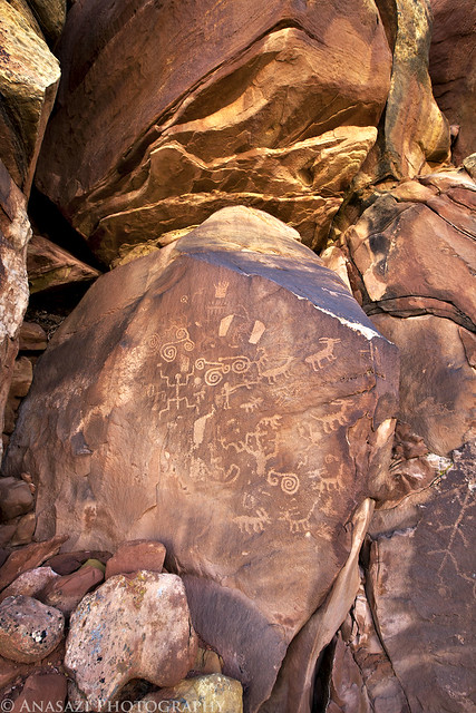
Notch Panel Right by IntrepidXJ, on Flickr
The two large petroglyph panels found here.
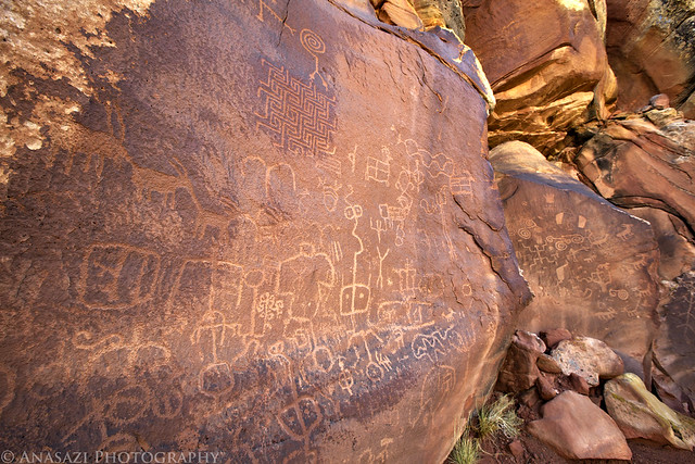
Notch Panels by IntrepidXJ, on Flickr
A spiraled-snake hidden on a boulder.
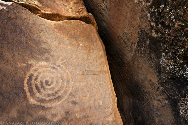
Spiral Snake by IntrepidXJ, on Flickr
This is probably my favorite part of this panel. The large maze-like design is very unique, but the two-headed snake above it is way cool!
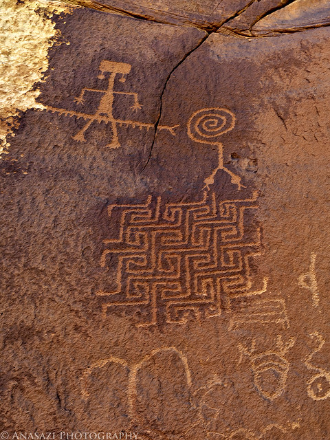
Two-Headed Snake by IntrepidXJ, on Flickr
After visiting the petroglyphs we were on our way towards Paw Hole and the White Pocket.
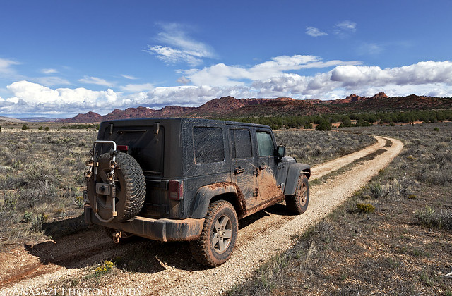
To White Pocket by IntrepidXJ, on Flickr
Follwing the sandy road near some sandstone teepees.
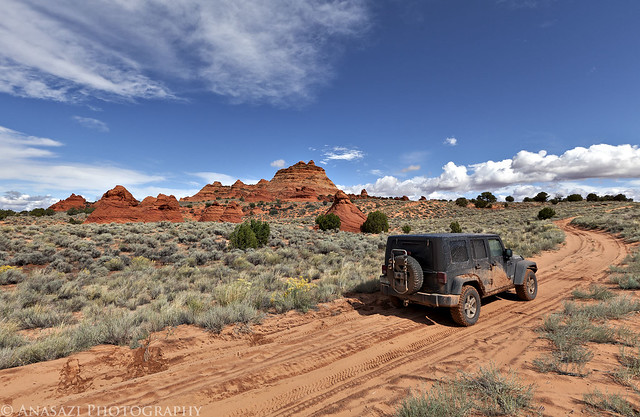
Sandy Road by IntrepidXJ, on Flickr
When we reached the intersection near Poverty Ranch we found a couple with a Dodge Dakota buried in the sand. I decided that I better stop and find out if they needed any help since it's a pretty remote area and we had not seen anyone else out there. After speaking to them we found out that they were on vacation from Switzerland and had rented this 4x4 truck so that they could visit the White Pocket. After we checked to make sure the transfercase was in 4x4 mode we had them try to drive out again. We saw that the front wheels were not spinning at all. Looking underneath the truck, it appeared that they had a broken CV joint which was most likely the problem, since all the power to the front axle would be sent to that side. We talked it over with them and came to the conclusion that they would probably not be able to get to the White Pocket without working four wheel drive. I got my Jeep behind their truck and winched them out of the deep sand an onto some firmer ground where they could turn around. Then we followed them back to the main road, just to make sure they did not get stuck again and that they got out safely. This set us back an hour or so, but it was definitely the right thing to do since they may not have been able to get out of the sand on their own, and it didn't appear that they were prepared to spend the night out there either. It was definitely our good deed done for the day!
Jared took a few photos of me winching the truck out of the sand. Since I rarely have needed to self-recover my Jeep, it was good to make sure the winch still works!
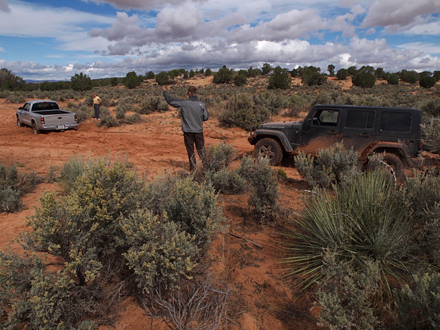
Deep Sand Recovery by xjblue, on Flickr
Winched out of the hole they had dug themselves into.
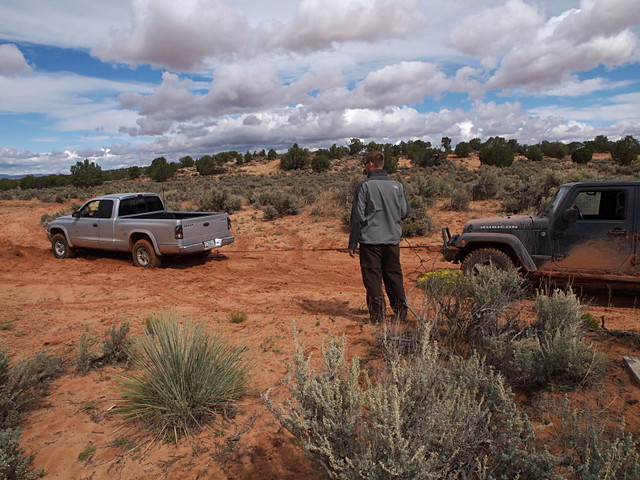
Deep Sand Recovery by xjblue, on Flickr
After making sure the couple was back on a good road, we turned around and continued back towards the White Pocket. We passed this small arch along the way.
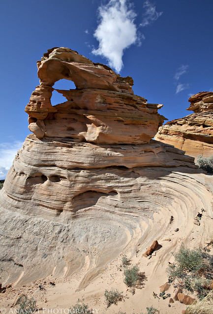
Twisted Arch by IntrepidXJ, on Flickr
Finally we made it to the White Pocket! We grabbed our cameras and hiked the short sandy trail.
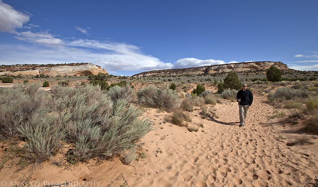
Short Hike to White Pocket by IntrepidXJ, on Flickr
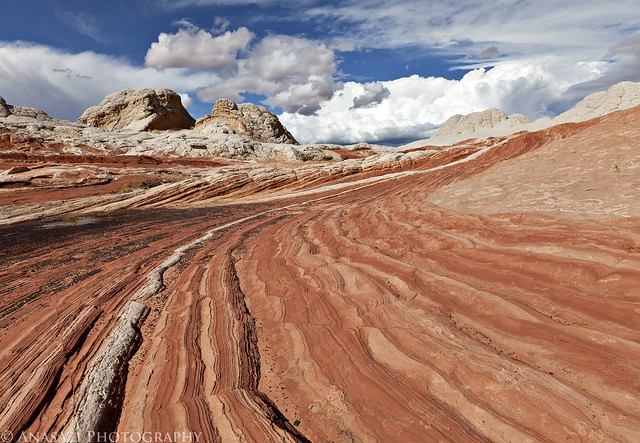
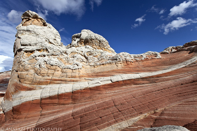
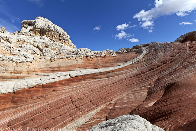
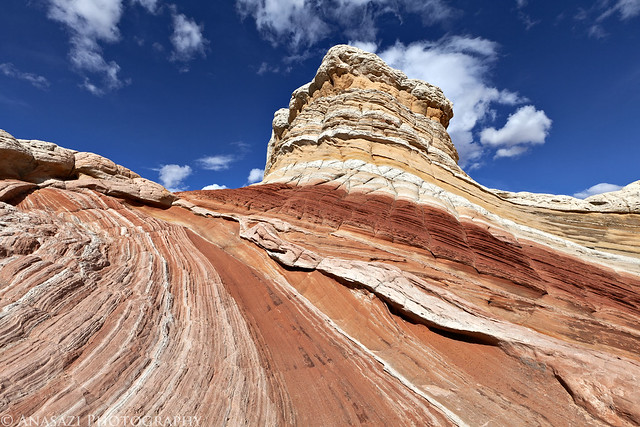
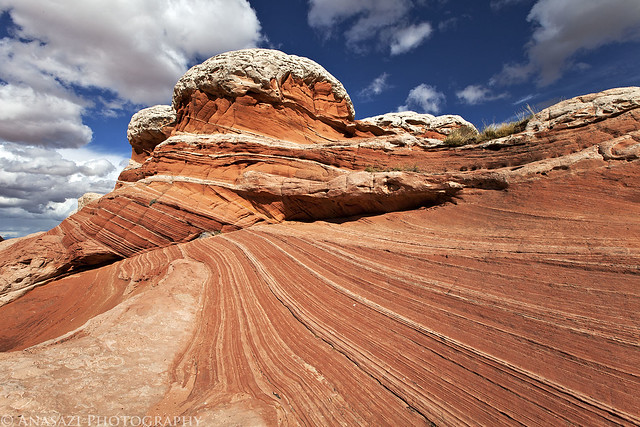
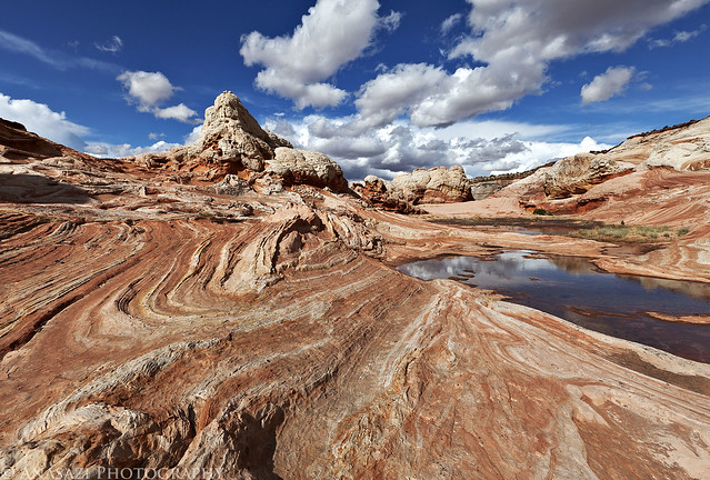
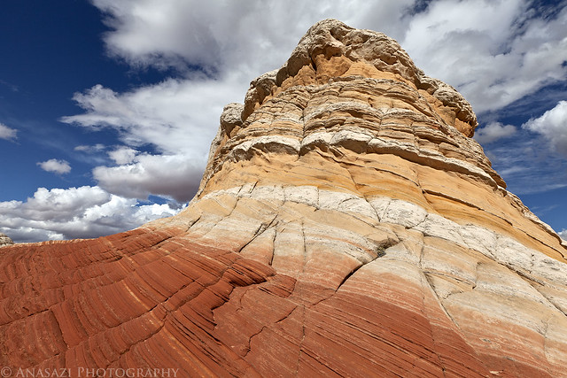
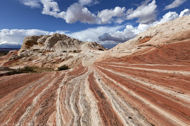
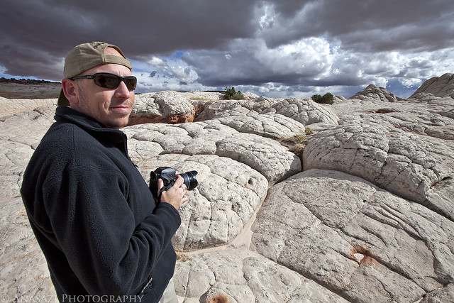
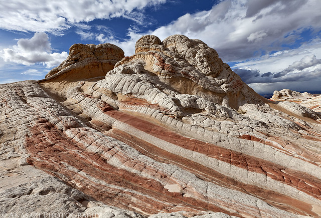
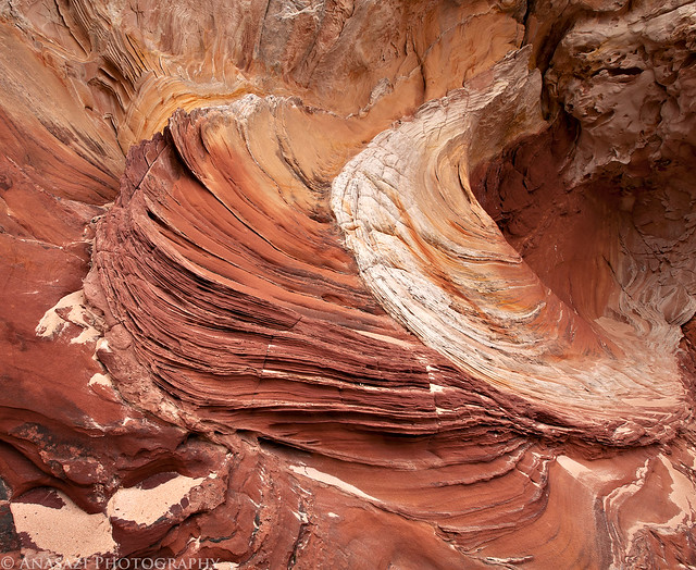
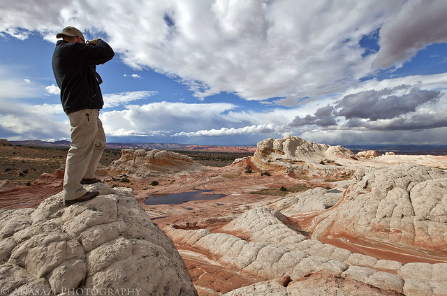
The White Pocket is an awesome place! Jared and I had a lot of fun just exploring this area and taking many photos. We also got lucky with the sky since there were many clouds moving quickly and constantly changing. The only downside was that the wind was blowing very hard the whole time we were there. There were many full potholes and puddles around, but the wind was blowing so hard that none of them were still enough for good reflections. This short visit was a good introduction to the White Pocket area and I'm sure that I'll be returning again in the future! Here are some of my better photos from the few hours we spent there...
To the Clouds by IntrepidXJ, on Flickr
Colors by IntrepidXJ, on Flickr
To the Sky by IntrepidXJ, on Flickr
Colorful Butte by IntrepidXJ, on Flickr
Lines by IntrepidXJ, on Flickr
White Pocket Landscape by IntrepidXJ, on Flickr
Stripes by IntrepidXJ, on Flickr

Jared & Storm Clouds by IntrepidXJ, on Flickr
Lines & Clouds Everywhere by IntrepidXJ, on Flickr
Jared by IntrepidXJ, on Flickr
Spiral by IntrepidXJ, on Flickr
Sandstone Design by IntrepidXJ, on Flickr
Over the White Pocket by IntrepidXJ, on Flickr
A storm behind us as we head back north into Utah.
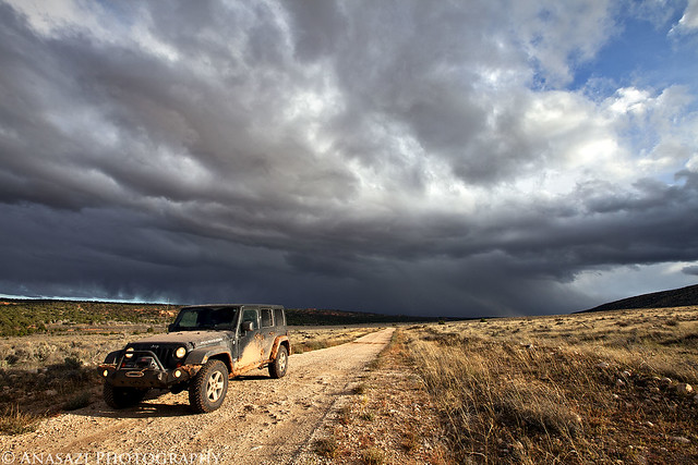
Storm by IntrepidXJ, on Flickr
Driving back on House Rock Valley Road close to sunset.
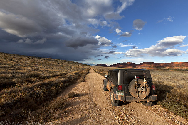
House Rock Valley Road by IntrepidXJ, on Flickr
We drove back through Kanab so we could grab a quick dinner and fuel up the Jeep before turning south again and driving up onto the Kaibab Plateau. We found our way to the trailhead for Snake Gulch and setup camp in the dark. There was a layer of small hail covering the ground when we arrived...it was going to be another cold night!
>> The White Pocket Photo Gallery
Thursday, October 6, 2011
The Original Trip Report on ADVENTR.CO
On Thursday we decided to take things easy again since we had another long hike planned for Friday. We didn't really have any plans for the day, so over breakfast we brainstormed some ideas and decided to head over to the White Pocket for the day. I had not been there before and it was on my long list of places to visit. Plus, since it had rained all night, we thought there might be some nice puddles and full potholes out there.
Shortly after turning onto the House Rock Valley Road on our way south to the White Pocket we came to the Buckskin Wash crossing. The water was high and flowing pretty good. In front of us were some people that were on their way to The Wave in a rental Jeep Liberty. We arrived just in time to watch them floor it and cross the wash with a lot of speed. Apparently they were pretty determined to put their permits to good use that day. They made it across fine and I drove across the wash with ease, putting my transfercase into 4x4 just to be on the safe side.
After crossing the state line into Arizona we parked the Jeep and hiked to the Notch Petroglyph Panel so that we could visit at least one rock art site. This is a view of the right side of the Notch Panel.
Notch Panel Right by IntrepidXJ, on Flickr
The two large petroglyph panels found here.
Notch Panels by IntrepidXJ, on Flickr
A spiraled-snake hidden on a boulder.
Spiral Snake by IntrepidXJ, on Flickr
This is probably my favorite part of this panel. The large maze-like design is very unique, but the two-headed snake above it is way cool!
Two-Headed Snake by IntrepidXJ, on Flickr
After visiting the petroglyphs we were on our way towards Paw Hole and the White Pocket.
To White Pocket by IntrepidXJ, on Flickr
Follwing the sandy road near some sandstone teepees.
Sandy Road by IntrepidXJ, on Flickr
When we reached the intersection near Poverty Ranch we found a couple with a Dodge Dakota buried in the sand. I decided that I better stop and find out if they needed any help since it's a pretty remote area and we had not seen anyone else out there. After speaking to them we found out that they were on vacation from Switzerland and had rented this 4x4 truck so that they could visit the White Pocket. After we checked to make sure the transfercase was in 4x4 mode we had them try to drive out again. We saw that the front wheels were not spinning at all. Looking underneath the truck, it appeared that they had a broken CV joint which was most likely the problem, since all the power to the front axle would be sent to that side. We talked it over with them and came to the conclusion that they would probably not be able to get to the White Pocket without working four wheel drive. I got my Jeep behind their truck and winched them out of the deep sand an onto some firmer ground where they could turn around. Then we followed them back to the main road, just to make sure they did not get stuck again and that they got out safely. This set us back an hour or so, but it was definitely the right thing to do since they may not have been able to get out of the sand on their own, and it didn't appear that they were prepared to spend the night out there either. It was definitely our good deed done for the day!
Jared took a few photos of me winching the truck out of the sand. Since I rarely have needed to self-recover my Jeep, it was good to make sure the winch still works!
Deep Sand Recovery by xjblue, on Flickr
Winched out of the hole they had dug themselves into.
Deep Sand Recovery by xjblue, on Flickr
After making sure the couple was back on a good road, we turned around and continued back towards the White Pocket. We passed this small arch along the way.
Twisted Arch by IntrepidXJ, on Flickr
Finally we made it to the White Pocket! We grabbed our cameras and hiked the short sandy trail.
Short Hike to White Pocket by IntrepidXJ, on Flickr
The White Pocket is an awesome place! Jared and I had a lot of fun just exploring this area and taking many photos. We also got lucky with the sky since there were many clouds moving quickly and constantly changing. The only downside was that the wind was blowing very hard the whole time we were there. There were many full potholes and puddles around, but the wind was blowing so hard that none of them were still enough for good reflections. This short visit was a good introduction to the White Pocket area and I'm sure that I'll be returning again in the future! Here are some of my better photos from the few hours we spent there...
To the Clouds by IntrepidXJ, on Flickr
Colors by IntrepidXJ, on Flickr
To the Sky by IntrepidXJ, on Flickr
Colorful Butte by IntrepidXJ, on Flickr
Lines by IntrepidXJ, on Flickr
White Pocket Landscape by IntrepidXJ, on Flickr
Stripes by IntrepidXJ, on Flickr
Jared & Storm Clouds by IntrepidXJ, on Flickr
Lines & Clouds Everywhere by IntrepidXJ, on Flickr
Jared by IntrepidXJ, on Flickr
Spiral by IntrepidXJ, on Flickr
Sandstone Design by IntrepidXJ, on Flickr
Over the White Pocket by IntrepidXJ, on Flickr
A storm behind us as we head back north into Utah.
Storm by IntrepidXJ, on Flickr
Driving back on House Rock Valley Road close to sunset.
House Rock Valley Road by IntrepidXJ, on Flickr
We drove back through Kanab so we could grab a quick dinner and fuel up the Jeep before turning south again and driving up onto the Kaibab Plateau. We found our way to the trailhead for Snake Gulch and setup camp in the dark. There was a layer of small hail covering the ground when we arrived...it was going to be another cold night!
>> The White Pocket Photo Gallery