The Mystery of Kim and Carole

I went to their final resting spot last week. This was a humbling and emotional experience. A special place for sure. Thanks again Dave for your time and research on this and to everyone else's thoughts and theory's. This story continues to fascinate me. Their memory will live on but their unfortunate tragedy has helped me be better prepared when I backpack.
 
I went to their final resting spot last week. This was a humbling and emotional experience. A special place for sure. Thanks again Dave for your time and research on this and to everyone else's thoughts and theory's. This story continues to fascinate me. Their memory will live on but their unfortunate tragedy has helped me be better prepared when I backpack.
Curious, which way did you approach from?
 
Curious, which way did you approach from?
I've been to hidden lake area several times. But this time I went from Long Lake and down the Middle Fork of the Weber trail. I wanted to go to Jerry Lake and this destination made it easier to get to their final resting spot.
 
This is an absolutely fascinating story. Newbie DaveK here. I found this site when googling about ONE of the latest victims of Uintas, Melvin Heaps (the other being the young HS student who apparently suffered some kind of altitude 'sickness', just 17). I remember the news report of Kim & Carole. This documentary (this special feature website) is certainly worthy of an HBO or Netflix special. I'm amazed at the tenacity and level of research that went into this web 'special'. It really is a compelling story, told as faithfully as any story I've ever read with a humble conviction to let the facts speak as is and the chips to 'fall where they may'. Excellent.
 
I just can't get this story/event out of my head... Did these two experienced hikers really make mistakes or were they simply unaware of the hazards of hiking this high country? What may be well known and understood by your local folks may not be obvious to us other folks (me from the mid-Atlantic Balto/Wash area). Having been blessed to have traveled just a little out west, the people there (you all) grow up with a healthy respect for nature. At an early age, you all learn things can turn dangerous quickly. Us flat-landers and urban folks deal with weather mostly as an inconvenience. It's something that interferes with our normal lives. When it's nice, we don't pay much attention. When it doesn't suit us, we complain.
The many pictures of the area (besides being breath taking beautiful) suggest a friendly, benign, welcoming, safe, easy, pleasant, lovely area. It's LOOKS so unassuming, so inviting, so innocently beautiful. Having been to one of the Utah tourism sites (I'm guessing there are probably many), I perused the links on visiting/hiking the high country parks. There's nothing there I found to give a clue-less visitor the proper warning that I think should be given. I'm not picking on Utah, after they are just one of many states vying for tourism $$$ and no tourism website is going to go out of their way to suggest risk or danger or anything less than 100% fun, fun, fun and a lifetime of memories.
Is the trailhead reached only by going past a ranger station that compels people to sign in? Are there ANY signs at any trailheads that provide ANY warning or guidance? Do any trail books provide ANY guidance / warnings/ recommendations on hiking the high country for the trails in question?
The more I read and ponder the more I think these two (probably wonderful, wonderful people) simply were unaware of the dangers of hiking the high country Uintas. Why would they think to "sign in" for a day walk? If they didn't perceive any danger, and the list of photos of places they visited suggests they didn't, why carry a ton of survival gear? And they didn't look completely unprepared, light jacket, hiking pants, backpacks, map, etc. It's not like they drove up, jumped out of their car wearing shorts and Ts, and then ran off into the wilderness, ignoring any trail. They weren't clue-less, or careless. They seem to have been caught off guard. The weren't pummeled by a storm of the century. They seem to found themselves quite innocently in a fight for their lives.

Only speculation...but I think a big factor was as you have pointed out, they were not locals. They were from out east where weather patterns and climate is far different. Altitude could have played a role. It was in the shoulder season where the day can be pleasant, sunny, and warm, and that evening can quickly become stormy, snowy, and very, very cold, especially for someone from the southeast. The Clyde Lake loop can be hiked in two hours, so it'd be tempting to only pack and prepare for current weather conditions. Trailhead boards do warn of dangers and being bear aware and all that, but often people just pick up, download, or print off a a map and just go without taking time to review details laid out on a trailhead board. Sometimes those trailhead boards get weathered real bad before they are redone. Sometimes they get vandalized. Even very experienced and very knowledgable outdoor enthusiasts still fall victim to the hazards of being outdoors from time to time. For me...the terrain in that part of the Uintas is very very tame and mild and because I'm familiar with all the surrounding landmarks, it'd be very hard for me to see myself getting lost in that area. For others, that area can be very rugged and disorienting. Unfortunately, there is now another hiker that has been missing for over a week now that was last seen at the same trailhead. It is the most used trailhead in the Uintas. In this case, the hiker is elderly and alone, so even as a local, his age and health may have played a factor in his recent disappearance. Again, all speculation...but relative to other parts of the Uintas, this area in discussion here sees a majority of the use. Lots and lots of people hike, fish, and camp throughout this area using the same trailhead and again. For this particular area, I think it comes down to having good health, being prepared for both potential day and night conditions in that season, and being familiar with the landmarks around you so you don't become disoriented with your location.

Having just come back from a trip up to Yellowstone...that was a place where I could understand it becoming very easy to get lost in the backcountry there.
 
Did these two experienced hikers really make mistakes or were they simply unaware of the hazards of hiking this high country?

As many others here have, I attempted to walk their path to try and understand what happened.
My report is found here My Search for Kim & Carole.

Based on the research of @Dave and walking the path myself, I'm convinced they made
conscious choices in going the way they did. All the way past Hidden Lake they are taking
pictures of each other, not something I believe they do under duress.
I think they ran into trouble during their circling of Mt Watson.

When I walked it, I took what I thought was going to be the most direct route to their
shelter.

It was tough terrain with moderately thick growth. Being wet and tired it's not very
hard to imagine either one of them twisting an ankle, breaking a leg, something that
stops them and then the temperature drops overnight and they suffer hypothermia.

So did they make a mistake?
Only if you think leaving the trail was a mistake, or going into the mountains was a mistake,
or going to Utah was a mistake. How far upstream of our choices do we have to go
to undo what happens in our lives?

But I don't think they did. The combination of injury and cold weather, I believe,
is what cost them their lives.

If nobody is injured they keep walking and get out. If overnight temperatures don't
bring hypothermia, the non injured one walks out the next morning, gets help and
they get out.

Welcome to BCP @DaveK
 
I mean no disrespect and if anything, have placed myself in their shoes, excepting I'm completely total novice. Yes I've hiked a little bit here or there, but it's been the mostly, follow the well marked trail or grab a trail map from the ranger's office and do the 2 hr loop. The most I ever took with me was granola bar and some water. I had the clothes on my back, a hat, and maybe a lightweight jacket tied to my waist. These two seemed prepared, maybe not completely well prepared for the high country, but neither completely unprepared. I was up last night for a bio break and water and just couldn't get back to sleep with so many questions swirling around my head.
1. Who were these people? Carole,a registered nurse and her daughter. What of them and their lives? They had family, as members of their family flew to Utah after they were reported missing. And that's one of the things that remains with me. They left the east coast for Utah telling their family to expect them the following week on Saturday September 13th. That strikes me so unusual. Was this typical of this mother / daughter pair to go away yearly on hikes, telling their families we'll see you in a week? I've found myself away from my wife and she from me, but we call each other, even if just for a few minutes daily. I know it's not PC but women are more social than men. I can see a dad/son going on a week adventure and not making plans on calling family for a week, but not women. For one of the pair, to not call family daily is a stretch for me but believable, but for two people living one in Georgia and one in Florida NOT to plan to call a family member daily, it's something I just don't understand.
2. What kind of experience did Carole and Kim have? The various news sites that still have their stories call them experienced. Do we know how experienced? Living where they did, they certainly would know of and maybe hiked the Appalachian trail. Now it probably pales to anything out west but people do get lost and rescued. (I'm not sure how many or if any perish). Did they have high country skills?
3. What was the nature of the interaction between the park ranger and Kim and Carole, when did the interaction take place, where did it take place.? Again, I can't get this out of my mind. Women tend to be way more risk adverse than men. If warned, what was the nature of that warning? Was is a casual, hey folks, you know you've got to be a little better prepared for bad weather - type of thing or was it confrontational? Something like, you two are not dressed for this high country weather. Let me see your survival gear. Open those backpacks. No, no, no this is completely unacceptable. You are not prepared. I'm telling you, go back into XYZ and get rain gear and cold weather gear before you come back on this mountain, understand? Why would they ignore a warning from an authority figure? What time did they interact? Was it 9:00AM (early enough to go somewhere, buy gear and return) or 11:00-12:00 much to late to salvage the day?
4. If a ranger issues a dire warning (if the warning was dire) would they (the ranger) not return sometime during the day check to see if the visitors complied with the warning? Here in MD most of the parks I occasionally visit are closed a dusk. The park is 'swept' for vehicles to make sure all have left, excepting those who are registered to camp. Aren't the trailheads swept daily? Is it my east coastness, but if I were a ranger and warned you that you weren't prepared, I'd be checking the trailheads to see if you complied because I'd be darn angry if you ignored my warning. Were people hiking Sept 8th through Sept 12th so that lots cars come and cars go and single, specific car would stand out?
5. Why didn't they sign in at either of two stations? Was it because they were warned not to hike and thought, Ok let's keep a low profile, hike a short trail and then get out of dodge before we get in more trouble? Did they get mesmerized, planing just a short, quick hike then were overcome by the beauty and vastness of the place, and perhaps feeling euphoric, said, this is unbelievable, let's press on! Did they simply say, you know, we're not going to be camping, just a day hike, there's no need to sign in?
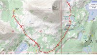
6. Just how long were they hiking? Given the photographic evidence, did they hike 6 hours, 8, 10 hours? When did they arrive in Utah? Did they spend a day relaxing, getting acclimated to the thin air for a day or two before departing on one of 4 or 5 day trips to various destinations. Or did they fly in on Sunday Sept 7th, and use Monday as a easy hike to get acclimated... Given both were living essentially at sea level, what kind of stress was placed on their bodies being at 10,000+ ft for X hours? Were they completely spent? Exhausted? (I guess not based on the pics, as they look so happy and full of life, enjoying the beauty all around them).
7. I'm not picking on Utah as Heavens knows I'm looking forward to retiring in a few years and would love to go back out west to see Utah and other western states, but even today, with as many mishaps, what kind of warnings are there for visiting folks (and not just Utah but the Rockies in general). Are ANY of the lakes in this story physically marked with name, GEO coordinates, and orientation (N/S/E/W)? E.g, big stone boulder or sign, you are HERE at xyz lake? Have any guidebooks or websites provided links or provided information on surviving the high country. I suspect not. It's a shame people are occasionally lost for lack of information and yes I completely understand people SHOULD carefully research any undertaking, but when you don't know, you may not know that you don't know.
Apologies in advance.
 
I haven't done hardly any hiking back East, but the West is just too big and the rangers stretched too thin to check up on people like you're saying they do back there. There are too many places a person can park and take off for rangers to do nightly sweeps, though if someone notices a car that's been sitting for a few days, it will probably be checked. Also, there's the unwritten expectation that we have the right to do what we want, as long as we're not tearing things up, so most rangers won't turn into cops and make sure you're prepared and lecture you if you're not. You're expected to take care of yourself, you're an adult. It might be a cultural difference, but out here, if someone tries to babysit you, they're typically going to get some resentment. Most of the people I know who hike don't want to be policed, that's part of what they want to get away from. To put warnings and signs everywhere would quickly detract from the wilderness experience, and I would personally find that insulting and nannyish.

I think they just weren't aware of how quickly things can go bad weather-wise and chose to optimistically ignore the ranger, thinking it was just a short dayhike and nothing much could happen. I feel they were unprepared, one should at least carry a firestarter of some kind. Once you come out here and start hiking, you'll get a feel for how easy it is to get caught up in the landscape and how benign it can feel. It's really easy to overestimate your own capabilities. And most of the time, you'll be OK. There are a lot of people that come out and hike who have no experience or common sense, and they end up just fine with lots of nice photos. The mountains are generally easy to get along with and wish you no harm.

As for calling home, for me, part of the experience is to ditch as much technology as possible. It gives you a sense of freedom to get rid of the electronic leash. But do we know they didn't intend to call once in awhile?

I'm wondering if maybe once you're out here you won't find some resolution with your feelings, as you'll see that it's really not that common on a percentage basis for people to go missing. If you're even marginally prepared and pay attention to the weather and carry a map/compass if you go off-trail, you should be able to enjoy the wilderness and still live to a ripe old age - there are lots of visible landmarks in the mountains and if you pay attention, you should pretty much know where you are, unless you're hiking in thick forest, and even then you can usually find a viewpoint. The topography out here makes it easy to find landmarks to navigate from, unlike the thick forests back there, but most people don't even go off-trail. Reading about someone who died in the wilderness can certainly make one more fearful, but keep in mind they may have been injured, and hypothermia will make you disoriented. If you carry a PLB, you can always summon help. There's really very little to fear way out there - you're generally safer than in a city. But what it boils down to in the end is that we're each responsible for our own safety, and IMO, that's how it should be. That's part of what makes it so special.
 
Last edited:
Well clearly you haven't spent much time out west, these areas are huge, there would be no possible way for rangers to patrol all the trailheads and pullouts, nor any logical way for them to keep track of everyone they have seen and what cars they were driving, etc...... I've put hundreds of miles down in the Uintas and never actually met a ranger on the trail. There are over 550 miles of trail just in the Uintas, dozens and dozens of trailheads, and only a handful of rangers. You are on your own, and that's part of the appeal.
 
I have not spent hardly and time out west, only fortunate enough to have day hiked lots of national parks a million years ago, when I graduated HS and traveled the summer before college. I do hope to get back out west again when I retire, hopefully in a few years. I've done enough Google searches now to see that yes, unfortunately, it's not completely uncommon for those unprepared to vanish in the vast wilderness of the west (and even for those prepared to 'vanish' as well). Still I'm humbled by this story and for those who tenaciously pursued details for the full story. Having watched a number of Netflix documentaries, this story (I think) certainly qualifies. (BTW if you haven't there's a pretty neat documentary from Netflix called 'The Barkley marathon, the marathon that eats its young'. It's about an undocumented, non-advertised extreme race hosted here in the east, in the Appalachians... )
I understand and agree completely, anyone hiking in unfamiliar territory in a vast region, especially mountainous, has the ultimate responsibility to research and understand the risks and be prepared accordingly. Unfortunately, it just seems like - with so much technology and relative ease of living, so many of 'us' (me included) no longer has an experience base (directly or from community) to ascertain, evaluate, even know of the risks involved in mountainous hiking. Thanks to all for bearing with me on this story.
 
Here in MD most of the parks I occasionally visit are closed a dusk. The park is 'swept' for vehicles to make sure all have left, excepting those who are registered to camp. Aren't the trailheads swept daily? Is it my east coastness, but if I were a ranger and warned you that you weren't prepared, I'd be checking the trailheads to see if you complied

I'm another east coast hiker, but the places I backpack don't have the resources to "sweep" trailheads and that includes Great Smoky Mountains NP (the most visited NP in the country). Over the last couple years, I have spent approximately 20 nights in the Smokies and only seen a ranger on the trails once. Depending on the time of the year, it would be very easy to snow bound and die and no one would find you for weeks.

If you go out into the woods, you better make good decisions or you may pay the price.
 
I hope that I do not sound disrespectful to these ladies and their families but I have seen too many "experienced" outdoors people do some really unexpected things that suggest to me that "experienced" is too subjective of a term to have any real meaning. To some (with probably no experience), knowing that someone has hiked in Shenandoah NP 5 times, means that that person is experienced. Experienced should mean that they had some real skills, not just hiking down a trail and reading trail signs.

From what I have gleaned here, they had some water, some matches, a few snacks, one of them had a rain or wind jacket, the other had a cotton sweatshirt, they had a book with some poor maps, and there is no mention of other of the 10 essentials. Anyone who goes out like that is an obvious newbie, not experienced.

Having worked with a few people who became disoriented during the course of a day, one of the first things that seems to happen is that they lose faith in what information they have such as landmarks they can see or have seen, what direction they came from or need to proceed in, and that loss of faith leads to fear of being lost followed by creeping panic. Without a compass and USGS topo maps (and the knowledge to use them), they would likely have started down the cascading path of poor decision making. These were people that had at least a few weeks of time working (route finding, map and compass work, etc) in the mountains of central and western Montana. Some of them had a full summer's worth of experience.

I can only imagine the discussions that Kim and Carole had once they realized that they weren't where they thought they were. Without good maps and a compass and the skills to use them, they probably lost faith in what they knew. Add in hypothermia, exhaustion, hunger, elevation, panic, lack of experience, ... I bet they changed directions multiple times before hunkering down.

A couple cases in point. On a recent trip to Yellowstone, my family and I ended up running into 2 groups that were disoriented. The first one was a man and woman who were on a trail but had no idea which one or where it led. After showing me on a Trails Illustrated map where they wanted to go, I told them that if they stayed on the trail, they would hit the parking lot in about 2 miles. As we were loading our gear into the car later, that man and woman were dropped off by a car at this parking area. It appeared that they had to hitchhike back to this parking lot (their car was parked here) that the trail led to. Why did they not just stay on the trail as instructed?

The other group had come down the wrong trail (missed the turnoff) after a long day and missed their destination trail head by about 4 miles. Even though he ran into us at a huge landmark (a dam) that he had driven over to reach where he had parked, he had no idea which way to go to return to his car. I gave him a ride to his car.
 
"Experienced hiker" - I was pondering much the same as I've mulled over this story (and now the incomplete story of the 74 yr old hiker now lost from the very same trailhead as used by Kim and Carole years ago). What does that mean? So far as I know there's no certification or standard to say someone is an experienced hiker or not experienced hiker. The more I've read would seem that you are experienced if you've hiked a variety of difficult terrains, in a variety of adverse conditions (scorching sun, bitter cold, rain, sleet, blustery winds, lightning/thunderstorms, etc.). You have the skills that allow you to navigate and find your way using topological maps and compass and/or satellite GPS unit. So you can plot a course and follow it accurately and likewise can from your surroundings take bearings and establish fairly accurately where you are at on a map. You have camped overnight, deep into a trail on more than a few occasions. You understand the risks of the terrain you are hiking and have compensated accordingly in what you've outfitted yourself with. You can evaluate possible routes and assess risks, energy usage, time to hike, etc. You have survival skills and have outfitted yourself accordingly for the assessed risks. You understand the nature around you; weather, terrain, plant & fauna, wildlife, etc.
The above is not to suggest that only experienced hikers should enjoy the great outdoors and our wonderful national and state parks. Certainly most anyone can enjoy a park, no argument there. A well marked, well traveled trail that loops close to trailhead can enjoyed by anyone. But heading off into a remote area, miles from the trailhead, deep into the wild, on a trail that's not well marked and only marginally traveled, that's probably big league stuff.
 
This story certainly made an impression on me, mostly because I could identify with those unfortunate folks given my meager skills. I could easily see myself in their predicament and the thought has to be of unrelenting regret, cold & wet, exhausted, no shelter, no one anywhere near close, not hopeless but geez just beaten down into submission ... It's made me very aware of my lack of skills and sharpened my desire not get into that situation as I plan (a few years out) hopefully traveling this great country to see our national and state parks up close and personal. So I've been to a number of sites and collected great information on not being a statistic. I bought a good compass from REI and am practicing using it. Heck I'm heading into western Massachusetts in a few weeks for a timber framing workshop. I'll be camping and will have an opportunity to hike on the Appalachian trail a day or so before the workshop starts. I'm not planning much of a hike (no overnight), maybe a morning or afternoon trip or two, but I'll be 'carrying' a ton more knowledge, gear, and respect. I'll start small and grow my knowledge and experience. So again, thanks to all for posting this story and advice.
 
Given that I consider myself a fairly “experienced” hiker and am a cartographer by trade, this detailed investigation caught my interest. Also, I grew up in the Salt Lake City area, have hiked the Uintas a few times over the years, and like the author, attended the East Fork of the Bear scout camp when I was a Boy Scout back in the early 90s.

It is my observation that Kim and Carole considered themselves experienced enough hikers as to feel confident in leaving an established trail to visit Hidden Lake. Novice hikers generally do not leave an established trail, especially if they will lose sight of that trail and it is an area that is unfamiliar. Even with all of my hiking experience over the years (including going off trail with the aid of topo maps), I generally would not seriously consider leaving a trail if I didn’t have a topo map or I was totally unfamiliar with the area. Kim and Carole’s decision to leave the trail to visit Hidden Lake was a calculated risk—they saw it as a prominent feature on a map and felt confident enough that they could get to it. I see myself as experienced enough in hiking that I might make that same decision.

However, I’m struggling with the idea that they indeed made the conscious decision to try to circumnavigate Mount Watson to “shortcut” their way back to the Crystal Lake Trailhead after visiting Hidden Lake. Clearly the weather was suspect and they were unfamiliar with the terrain south of Hidden Lake. Furthermore, I have read from others who have attempted to retrace their steps from Hidden Lake to their final resting place that within a 1/4 mile south of where their last photo was taken the terrain becomes quite challenging. It doesn’t make sense to me why they would be so determined to go around the mountain given the deteriorating weather, rough terrain, and zero familiarity with that area.

Then there is another element that I didn’t see addressed in the author’s investigation—time. The straight-line distance between the last photo location and their final resting place is only approximately 1 mile. So let’s say Kim and Carole intentionally attempted to circle Mount Watson and averaged 1mph over the rough terrain for that mile, it still should have only taken them about 1 hour to hike to their final resting place. So do we know the approximate time of day when that last photo was taken? Let’s just say it was around 2:00pm— then they would have hunkered down at their final resting place around 3:00pm. So if one of them was hurt and could not walk, there would still be several hours of daylight left for the other one to go find help by heading around the mountain to the Long Lake area. I find it unlikely in this scenario that both Kim and Carole were injured to the extent that they were both unable to walk.

Another route possibility that I don’t think was considered in the investigation is that Kim and Carole returned to Clyde Lake after taking that last photo and then perhaps very soon lost the trail (for whatever reason), and then became disoriented—ending up on the Middle Fork Weber River Trail near Long Lake (as shown in attached map).

I believe that this could be a reasonable scenario because: 1) it seems more likely that the hikers became disoriented as some point as opposed to intentionally circling Mt. Watson—the rain and low clouds may have reduced visibility to the point that they lost their bearings, 2) it accounts for the time between the last photo and nightfall—theorizing that Kim and Carole may have gone back and forth after leaving the trail somewhere soon after Clyde Lake to try to find where they left the trail—but couldn’t locate it given their disorientation and then headed in what they thought was the direction to their car, and 3) it makes more sense as to why their remains were found only about 400 feet from the Middle Fork Weber River Trail— after becoming lost/disoriented they eventually had to find a spot to hunker down for the night and tried to find a suitable shelter that was reasonably close to the trail.
 

Attachments

  • Capture.JPG
    Capture.JPG
    145.4 KB · Views: 85
Then there is another element that I didn’t see addressed in the author’s investigation—time. The straight-line distance between the last photo location and their final resting place is only approximately 1 mile. So let’s say Kim and Carole intentionally attempted to circle Mount Watson and averaged 1mph over the rough terrain for that mile, it still should have only taken them about 1 hour to hike to their final resting place. So do we know the approximate time of day when that last photo was taken? Let’s just say it was around 2:00pm— then they would have hunkered down at their final resting place around 3:00pm.

I've always assumed it was later in the day, but I have no confirmation of that.

Another route possibility that I don’t think was considered in the investigation is that Kim and Carole returned to Clyde Lake after taking that last photo and then perhaps very soon lost the trail (for whatever reason), and then became disoriented—ending up on the Middle Fork Weber River Trail near Long Lake (as shown in attached map).

I believe that this could be a reasonable scenario because: 1) it seems more likely that the hikers became disoriented as some point as opposed to intentionally circling Mt. Watson—the rain and low clouds may have reduced visibility to the point that they lost their bearings, 2) it accounts for the time between the last photo and nightfall—theorizing that Kim and Carole may have gone back and forth after leaving the trail somewhere soon after Clyde Lake to try to find where they left the trail—but couldn’t locate it given their disorientation and then headed in what they thought was the direction to their car, and 3) it makes more sense as to why their remains were found only about 400 feet from the Middle Fork Weber River Trail— after becoming lost/disoriented they eventually had to find a spot to hunker down for the night and tried to find a suitable shelter that was reasonably close to the trail.

So if I understand you correctly, and the line you have on the map, you're suggesting
that they got to the meadow on the southwest side of Hidden Lake, ( a known fact based on photos)
decide that they need to get back to the trail, head southeast to Clyde Lake, are so disoriented
that they actually circumnavigate Watson in a clockwise fashion, eventually ending up in the final
resting spot?
 
I've always assumed it was later in the day, but I have no confirmation of that.

It is difficult to tell what time of the day that last photo in the meadow was taken (or any of the photos for that matter, given the overcast skies). If it's true that Kim and Carole left the trailhead parking lot after speaking with the ranger (but then returned), I have to wonder how much of a later start they got for the hike than what they had planned on initially. I haven't seen anything about the time that the ranger spoke with them, but I'm assuming it was sometime in the morning.
 
So if I understand you correctly, and the line you have on the map, you're suggesting
that they got to the meadow on the southwest side of Hidden Lake, ( a known fact based on photos)
decide that they need to get back to the trail, head southeast to Clyde Lake, are so disoriented
that they actually circumnavigate Watson in a clockwise fashion, eventually ending up in the final
resting spot?

Yes, the last photo spot --> Clyde Lake --> Long Lake area --> final resting place scenario is a possibility that I'm suggesting, although I agree it is hard to believe that one could get so disoriented as head the complete opposite direction from the Crystal Lake Trailhead and end up where they did. But there are numerous accounts of people disoriented in the mountains and ending up somewhere totally unexpected. That last photo in the meadow could have been the "here's our last view before we start heading back to where we came from at Clyde Lake," but that's just speculation of course. The scenario I'm suggesting is predicated on Kim and Carole not intending to circle Watson by continuing south from that last picture spot. It's also a way to try to account for the amount of time that elapsed between when that last photo was taken and nightfall.
 
I’ve walked around Watson both directions and hiked over it. The terrain going clockwise from their final photo spot all the way around to the final resting spot is not insignificant. It would take a wet and exhausted hiker hours to make the trip. It is no less rough (and in some ways more so) than the stretch on the northwestern side. Not only that, but Trial Lake, Washington Lake and the Crystal Lake TH are all clearly visible from the southern foot of Watson.
 

Similar threads

Back
Top