wow tough, thorough reporting a la Jon Krakauer "Into Thin Air" or "Into the Wild." If you're not working on a book you should be. Every day thousands of people endanger themselves going into the backcountry with good intentions but loosely formulated plans .. It seems especially relevant now, given the long range forecasts I've seen predicting warmer, wetter weather than usual for this area? Warm enough, that is, to lure people outside but not warm enough to prevent hypothermia at higher elevations, in wet conditions. Such a tragedy when an innocent trip like this ends up with two people dying.
Navigation
Install the app
How to install the app on iOS
Follow along with the video below to see how to install our site as a web app on your home screen.
Note: This feature may not be available in some browsers.
More options
Style variation
You are using an out of date browser. It may not display this or other websites correctly.
You should upgrade or use an alternative browser.
You should upgrade or use an alternative browser.
The Mystery of Kim and Carole
- Thread starter Dave
- Start date
DrNed
The mountains are calling and I must go
- Joined
- Mar 31, 2013
- Messages
- 1,026
So many other thoughts after reading the forensic report.
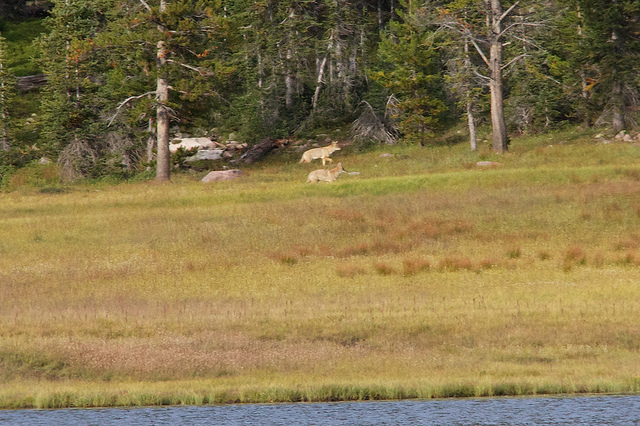
First, I didn't know we had coyotes in the Uintas. Second, either I missed it or there wasn't a detailed list of personal items found.
Did they have a map with them? Without a map with them, the idea of intentionally circling Mount Watson doesn't make sense to me.
Also, a first aid kit and unused matches have been mentioned. Knowing what I know now, I'm leaning toward the idea they never tried to use those things, for whatever reasons, and that they were open and about because of scavenging animals.
Which would lead me to believe they did not see their death looming and that they fell asleep and just never woke up.
So much more to think about now.
Thanks again.
- Joined
- Aug 9, 2007
- Messages
- 12,967
First, I didn't know we had coyotes in the Uintas.
There sure are. Here's a couple at Allen Lake near Four Lakes Basin around 10,400' (link to trip report).

DrNed
The mountains are calling and I must go
- Joined
- Mar 31, 2013
- Messages
- 1,026
Wow! Very cool.There sure are. Here's a couple at Allen Lake near Four Lakes Basin around 10,400' (link to trip report).
- Joined
- May 5, 2012
- Messages
- 1,732
My thoughts are that it wasn't an intentional circumnavigation of Mt. Watson, not initially.
I agree with the "not initially." I don't think they meant to circle Watson from the outset. If that was a conscious choice, it didn't happen until Hidden Lake.
Going back to Clyde from Hidden means ascending a couple hundred feet. If you're used to living at sea level, and if you've already hiked five or six miles at 10,000 feet, that ascent is not insignificant. Looking back up that hill, knowing it's roughly a mile just to get back to the trail, you might start wishing there was an easier way.
So you take the path of least resistance, following the 10,200 elevation contour to the south.
It's entirely possible Kim and Carole did this while wandering, completely lost. But my gut feeling is that Kim and Carole deserve more credit.
My goal with this investigation was not to prove conclusively that they intended to circle Watson, only to show that it's plausible. The route is doable. If they knew about the Middle Fork trail and if they wanted to shortcut instead of hiking back up to Clyde Lake, then cutting south would be the way to go. It actually looks like a shortcut on some maps — though Hidden Lake is pretty much the midpoint of the orbit.
Ultimately, it's all speculation. I'd suggest though that no one should make up their mind about it until they stand in the small meadow from the final two pictures, asking "what if it were me?"
Wyatt Carson
Desert Vagabond
- Joined
- Apr 15, 2015
- Messages
- 334
Thanks for the detailed account.
I have found this chronicle of tragedy riveting since the first thread here. The unraveling mystery of their path was interesting but the images attesting to two happy sentient beings photographing their journey, unaware that these are their last few moments on earth is both frightening and gut wrenching.
These type accounts certainly cause me to re-evaluate my kit and mindset for backcountry off trail travel which we are addicted to even though I have done so and built on both for decades. Canyon country and mountainous terrain can throw a lot at a person in very short order.
I don't think they would have stopped at a campsite with a fire ring as shown in the image above...because there was no fire going and there was no perceived shelter there. In wet conditions it takes more than some matches to get a good warming fire up and going. If one simply has good rain gear and insulative, dry clothing, chances are very good that they will come through. Knowledge on how to get a fire going in the rain might make the trip kind of fun instead of such a sad tragedy. Good navigational skill might preclude a situation in the first place.
They were wet and cold and lost in some hard country with the dark coming down and that was enough...RIP...
pstm13
Auribus Teneo Lupum
- Joined
- Dec 27, 2012
- Messages
- 572
IMO gravity and poor conditions tend to pull people off course in rocky ridge lines like the one described. Inexperience magnifies the effect. My guess is that they just got off course and bivied in the wrong spot and with limited skills to keep warm.
There was a similar situation at Craters of the Moon a couple years ago. Both women died in the lava fields in late September from exposure.
Interesting Article on how people navigate in forests in overcast conditions
There was a similar situation at Craters of the Moon a couple years ago. Both women died in the lava fields in late September from exposure.
Interesting Article on how people navigate in forests in overcast conditions
Last edited:
DrNed
The mountains are calling and I must go
- Joined
- Mar 31, 2013
- Messages
- 1,026
Facinating read.Interesting Article on how people navigate in forests in overcast conditions
This article adds credability to the idea they circled intentionally, as MT Watson would be
a landmark that would contribute to walking straight or circling on purpose.
The more I think about it, the more I buy the idea they purposely tried to circle Watson.
The more I look at the pictures of their "shelter" the more I realize it's no shelter at all.
It's not a formation one would choose to get out of the rain. I think they would have
had to have some other compelling reason.
I can only think that the shirt was hung to serve as a marker for those they hoped would find them.
In one of the photos of the location, the one with the black dog, the guy has
a bandana over his face. Just an intersting observation.
In short, I buy @ashergrey conclusions.
In the spirit of wanting to be helpful, I did find a small typo in my most reading - if such things matter.
"The same can not be said for the MIddle Fork Weber Trail. It is so slightly used, in part,
because it doesn't lead to any high interest destinations. Trial guides do not highlight it.
The trail is primarily used by people on horseback."
- Joined
- May 5, 2012
- Messages
- 1,732
In the spirit of wanting to be helpful, I did find a small typo in my most reading - if such things matter.
They matter very much. Thanks for pointing it out. The error has been corrected.
Rockroller
Member
- Joined
- Sep 21, 2013
- Messages
- 51
Fantastic and very interesting read! I have been in that area and I have thought about what they must of went through but I can't imagine. I appreciate the time you spend researching this. Because of you we can keep the memories of Kim and Carole alive and honor their lives by knowing they were doing something they loved. How many people would know anything about these two if this unfortunate tragedy didn't happen. Everyone can use what happened to them as a learning experience. From this experience that happened to them and the research you did it may save someone else life because they will be better prepared.
BonnevilleMariner
Member
- Joined
- Aug 3, 2016
- Messages
- 8
Dave, I came across this post while searching for info on the Notch Mountain Trail, as I'm hoping to take the kids to The Notch this weekend. I recognized your name from my KNRS listening days.
Kudos on your investigation and this post. As a freelance journalist who dabbles in video and photography, I can't imagine how many hours you spent researching and putting this together. I can honestly say I've never seen a more thoroughly researched and documented piece of investigative journalism. Your photo approximations are excellent, as are your map tours and the overview video up top. What rig did your brother use for the aerial shots? Stunning stuff. Has anybody from law enforcement reached out to you about the very obvious discrepancies between the official narrative and what you've laid out here?
Oh, while I'm here-- can anybody provide me some info on the trail between Wall and The Notch? I'll be hiking with small children and I've got about a 4 hour window.
- Joined
- Aug 9, 2007
- Messages
- 12,967
Oh, while I'm here-- can anybody provide me some info on the trail between Wall and The Notch? I'll be hiking with small children and I've got about a 4 hour window.
Welcome to BCP. To keep from derailing this thread, start a new one in the Trip Planning section. Myself and others can provide plenty of input.
BonnevilleMariner
Member
- Joined
- Aug 3, 2016
- Messages
- 8
My apologies.Welcome to BCP. To keep from derailing this thread, start a new one in the Trip Planning section. Myself and others can provide plenty of input.
- Joined
- Aug 9, 2007
- Messages
- 12,967
My apologies.
No worries at all! The rest of your comment is totally relevant and I'm sure appreciated, I just don't want to let this one go too far of course.
")
DrNed
The mountains are calling and I must go
- Joined
- Mar 31, 2013
- Messages
- 1,026
Having been bumped, I read the entire entry again. Being my 4th reading,
beginning to end I'm struck with some new thoughts and questions.
First, the magnitude of such an investigation is mind blowing. Thanks again to
@Dave for years of research, boots on the ground study and pouring over the
evidence.
Next, some details that I glossed over previously, the presentation of the
following deductions and questions are much more random than organized.
1. After the encounter with the ranger at the trail head the story quoted says authorities
believe they then left the area. Was it ever confirmed by the ranger that they actually left?
If so it leaves the possibility, while remote, that they came back the next day. That changes
the narrative dramatically.
2. Having said that, the shirt found at the resting spot seems to match the one worn by Carole
on the shore of Wall Lake.
If it's only one day of hiking then coming from Long lake can't be supported.
3. Evidence seems to support that leaving Clyde was by choice and not aimless wandering.
A. I think it's safe to say that circling Watson was not the original plan.
B. I should point out that I'm assuming that their original plan was to do the Clyde Lake Loop.
If A&B are accurate, combine that with evidence that it was or had been raining, would suggest
to me that at this point they were not concerned about the weather.
It's pointed out that the area received .5" of rain on the 8th. In practical terms, how much rain
is that? Is that hours of heavy rain? Hours of light sprinkling? One short down pour?
4. When ever I"ve been in tough situations in the outdoors I've never concerned myself with
taking pictures, which leads me to the conclusion that heading to Hidden Lake was, again,
by choice and not aimless wandering.
The thing I struggle with here is the meadow shot south of Hidden Lake. Why would you
head that direction unless the descion had already been made to circle Watson?
5. If all of the above is accurate that suggests to me that their descion to circle Watson
was made rationally and not due to circumstances. Something like, "we're all the way out
here, let's just cut this way back to the car."
6. I tend to think that their resting spot was chosen right after some injury just as presented
in the narrative. If you buy the above deductions, then their descions to this point don't suggest panic.
Then injury occurs and they seek shelter. The healthy one stays with the injured one.
So, I deduce it was severe enough that healthy one is going to to have to hike out for help but it's
dark so we'll wait until morning. Except morning never comes.
- Joined
- May 5, 2012
- Messages
- 1,732
What rig did your brother use for the aerial shots? Stunning stuff. Has anybody from law enforcement reached out to you about the very obvious discrepancies between the official narrative and what you've laid out here?
Thanks for your kind remarks. I believe he used a DJI Phantom 4 Pro on these shots, as we had to hike the rig the whole way around the mountain.
On the law enforcement front, I've reached out officially to a couple people but received no response. My understanding through the grapevine is some of those involved feel there's nothing to be gained by digging this all up, as the results remain the same.
- Joined
- May 5, 2012
- Messages
- 1,732
It's pointed out that the area received .5" of rain on the 8th. In practical terms, how much rain
is that? Is that hours of heavy rain? Hours of light sprinkling? One short down pour?
A half-inch of rain for a Utahn is a lot. For someone in Florida, it's not very much. But the combination of a soaking rain and a cool breeze at elevation present a significant risk. Unfortunately, the weather station data is not fine-grained enough to say if the rain came in a single, strong pulse or a steady drizzle. But if you look at the picture from Clyde Lake, it's obvious the rock on the far side of the water is slicked with rain.
- Joined
- Jan 4, 2015
- Messages
- 2,909
I tend to agree with all of this except the injury bit. I think it's significant that Kim and Carole were not from mountainous regions and may not have understood how Euclidean geometry doesn't apply in the mountains. If you look on a macro scale, their entire trip had been climbing - up to the saddle north of Mt Watson. To me, it seems natural to say "hey, let's cut around this other side of the mountain; we can skirt the base so we don't get lost, and it should be all downhill back to the car!"Having been bumped, I read the entire entry again. Being my 4th reading,
beginning to end I'm struck with some new thoughts and questions.
First, the magnitude of such an investigation is mind blowing. Thanks again to
@Dave for years of research, boots on the ground study and pouring over the
evidence.
Next, some details that I glossed over previously, the presentation of the
following deductions and questions are much more random than organized.
1. After the encounter with the ranger at the trail head the story quoted says authorities
believe they then left the area. Was it ever confirmed by the ranger that they actually left?
If so it leaves the possibility, while remote, that they came back the next day. That changes
the narrative dramatically.
2. Having said that, the shirt found at the resting spot seems to match the one worn by Carole
on the shore of Wall Lake.
If it's only one day of hiking then coming from Long lake can't be supported.
3. Evidence seems to support that leaving Clyde was by choice and not aimless wandering.
A. I think it's safe to say that circling Watson was not the original plan.
B. I should point out that I'm assuming that their original plan was to do the Clyde Lake Loop.
If A&B are accurate, combine that with evidence that it was or had been raining, would suggest
to me that at this point they were not concerned about the weather.
It's pointed out that the area received .5" of rain on the 8th. In practical terms, how much rain
is that? Is that hours of heavy rain? Hours of light sprinkling? One short down pour?
4. When ever I"ve been in tough situations in the outdoors I've never concerned myself with
taking pictures, which leads me to the conclusion that heading to Hidden Lake was, again,
by choice and not aimless wandering.
The thing I struggle with here is the meadow shot south of Hidden Lake. Why would you
head that direction unless the descion had already been made to circle Watson?
5. If all of the above is accurate that suggests to me that their descion to circle Watson
was made rationally and not due to circumstances. Something like, "we're all the way out
here, let's just cut this way back to the car."
6. I tend to think that their resting spot was chosen right after some injury just as presented
in the narrative. If you buy the above deductions, then their descions to this point don't suggest panic.
Then injury occurs and they seek shelter. The healthy one stays with the injured one.
So, I deduce it was severe enough that healthy one is going to to have to hike out for help but it's
dark so we'll wait until morning. Except morning never comes.
Where, I'd wager, they went wrong is by underestimating how much slower they would travel off-trail. If it's early in the day up at Clyde Lake, they think they have plenty of time. But they start getting slowed down by deadfall and snarls of vegetation, and all of a sudden they're halfway done with their off-trail travel, and it's getting dark (foul weather also means early darkness). They can't make it back to the trail at Clyde Lake before dark, much less back to the trailhead, and so they decide to hunker down. The weather, previously cooperative enough, turns on them sometime during the night.
That to me explains why 1) they don't show any sign of consternation in the photos 2) why they continued to take photos (one generally doesn't stop to snap a selfie while lost), and 3) why they were found together, with no apparent signs that one of them decided to seek help.
Ultimately we'll never know. I do think, though, about the times I've deviated from my planned route. And what that would mean, were the worst to happen to me.
DrNed
The mountains are calling and I must go
- Joined
- Mar 31, 2013
- Messages
- 1,026
A half-inch of rain for a Utahn is a lot. For someone in Florida, it's not very much. But the combination of a soaking rain and a cool breeze at elevation present a significant risk. Unfortunately, the weather station data is not fine-grained enough to say if the rain came in a single, strong pulse or a steady drizzle. But if you look at the picture from Clyde Lake, it's obvious the rock on the far side of the water is slicked with rain.
So I was curious enough to find out more. This is what I found.
A half inch of rain means a moderate rain for 1-2 hours or a heavy rain for 30-45 minutes.
As you point out the photographic evidence shows rain starting sometime after leaving Hope Lake
and before the Clyde photo, yet they continued west, which would suggest to me a lighter, but steady rain.
DrNed
The mountains are calling and I must go
- Joined
- Mar 31, 2013
- Messages
- 1,026
Where, I'd wager, they went wrong is by underestimating how much slower they would travel off-trail. If it's early in the day up at Clyde Lake, they think they have plenty of time. But they start getting slowed down by deadfall and snarls of vegetation, and all of a sudden they're halfway done with their off-trail travel, and it's getting dark (foul weather also means early darkness). They can't make it back to the trail at Clyde Lake before dark, much less back to the trailhead, and so they decide to hunker down. The weather, previously cooperative enough, turns on them sometime during the night.
Your explanation is perfectly plausible.
The 17 pages of ideas that I've typed and then deleted contrary to your
hunker down theory are all based on "that's not what I would have done"
which isn't good deduction so I come back to: your explanation is perfectly plausible.
Thanks for keeping me thinking.