RyanP
Member
- Joined
- Mar 1, 2015
- Messages
- 770
The stars finally aligned for me to go backpacking in the San Juan mountains in SW Colorado. I had enough vacation time to take a big solo trip ("big" for me means five days), the weather forecast was perfect, I was physically feeling fine (very little knee/foot pain), and the smoke from the various wildfires across the West seemed to be clearing out down there. To top it off, the tourist train that usually brings backpackers into the heart of the Weminuche Wilderness was closed this year, so some of the most popular trails would hopefully be less so this year. With all of these factors working in my favor, nothing could keep me from heading south.
Day 1:
With the clear forecast, I decided to begin at the trailhead that starts right below treeline and then follows the CDT through rolling high alpine tundra down to the heart of the Weminuche.

When I got to this pond, I thought about filtering water because I didn't have a lot left. Then I started hearing the bleeting, and before I knew it, thousands of sheep were coming over the hill toward the pond. Even with my water filter and backup purification tablets, there was no way I was drinking that water or any similar water sources in that area! Luckily, there was a reliable (or so I thought) stream in a couple of miles, so I could wait until then to refill. The sheep dogs ran up barking aggressively at me when they saw me, so I had to run up the hill a bit away from the trail until they calmed down. I'm not generally scared of wildlife in the backcountry, but sheepdogs are a different story!

The views toward the Grenadiers started to open up. I was excited to be heading in there close and personal the next day.

The trail dropped down to a high-clearance, 4WD trailhead. It was disappointing to all of a sudden have ATVs and jeeps kicking up dust on the road around me. To make it worse, the stream I was counting on was dry, which surprised me---it was the outlet from a fairly large lake, and was marked solid blue on my maps. With no other streams on the map before the next pass, I decided I needed to make a side excursion up to the lake to get water. That side trip, though short in distance, was a hot, dusty trek along the jeep road, and it wasn't very scenic. Furthermore, I was struggling physically more than expected and was frustrated that I was already behind schedule on the first day of the trip. With all of the negative thoughts, I decided I needed to take a dip in the lake and relax a little to put my mind in a better place. After a nice swimming break, I headed back down to the 4WD trailhead and headed up the small pass, making my way toward the Vallecito river. Of course, there were multiple streams not marked on my map right after the 4WD trailhead! Oh well, the swim was nice.
On the other side of the pass, the views quickly began to improve and I found a nice spot to sleep. I had done about 10 miles that day and they were all easy miles on trail, but I was uncharacteristically exhausted and slept like a baby.

Day 2:
I woke up and hiked a couple of additional miles on-trail to a large meadow, where I left the trail to begin the off-trail adventure. The trail through this section was very scenic.

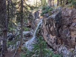
Days 2-4 of my trek were officially completely off-trail, but much of the "off-trail" travel in this area actually has unofficial, unmaintained use-trails that make the going easier. The trail in this first basin was hard to find and to follow, however, and I spent most of my time below treeline navigating around and over fallen trees. It was slower going than I expected, and I fell further behind schedule. The scenery was very nice though, hiking along a beautiful creek with a couple of waterfalls along the way:


When I got to treeline, the terrain got much easier, and the trail became easy to follow for a ways. I took my daily swim in this lake.

I climbed the steep, loose, nasty slope to get to the top of the pass at the end of the basin, and was greeted with spectacular panoramic views.

Getting down the other side of the pass was just as much of a pain as getting up it. I was starting to wonder if I really wanted to go through with my planned trip. This was supposed to be one of the easiest passes I would encounter, and it pushed me to the edge of my comfort zone. But once I got down into the upper part of the basin, I was in heaven. Surely this is one of the most beautiful places in CO, and I hadn't seen anyone else all day! (then I saw another camper in the distance right before I set up camp). As I set up camp, I decided I would at least get to the next pass, and make a decision from there.

The weather was calm enough to sleep under the stars, but when I did so the first night, I had some condensation on my sleeping bag (in my water-resistant bivy), so I decided to set up my duomid shelter to help reduce the condensation. This was not a great pitch of the shelter; I really need to figure out what I am sometimes doing wrong (note the sagging in one corner). This was an absolute top-notch campsite, with a waterfall (not shown in the photo) behind the tent and expansive views to the other side.

Day 3:
The next pass, while just as steep, loose, and nasty as the first, didn't seem any worse, so I made it up to the top. The views on the other side toward the Needle mountains were quite grand.

The descent on the other side was much nicer, with grass and more mellow slopes the entire way down. It was the longest descent of the trip, though, so my knees were grateful when I finally got to the lake!
And what a lake it was!

I was surprised to hear voices at the lake, as this must rank up there with the most remote lakes in the state. I met a couple of backpackers who were on their way out, so I soon had the lake to myself and enjoyed a nice swim to cool off.
There is sort of a faint trail on the other side of the lake that leads to a plateau above the lake. It was on nasty talus, but was not overly steep so I made surprisingly good time. The views kept getting better as I got higher up. This basin is truly a gem!


The plateau above the lake is probably one of my favorite places I have ever been. I hung out there for a little while, resting up before hitting yet another nasty steep pass.
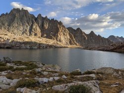
The next pass took me longer than any on this trip. I just struggled to identify the "correct" way up. I kept going part way up, only to realize that the slope was steep enough in that part for the rocks to be unstable, so I had to very carefully backtrack back down and pick a new line. I don't know why this pass was so tough for me to find the right way up. But the views were absolutely spectacular, so I was still having a good time overall. I finally made it to the top, and was now even further behind schedule. The panoramic view atop this pass was easily one of the best panoramic views I have ever seen. Here's the view to one side:

And here's the view to the other:

Descending the other side of the pass was quick and easy compared to the arduous ascent. I began exploring around the lake, searching for a good campsite.


I found a perfect campsite (at least on a calm night like this). Hands down one of my favorite campsites of all time. And I got the pitch right on my shelter this time!

One of my favorite things about backpacking is experiencing the evening in places like this. Evening is by far my favorite time to be outdoors, and having this basin completely to myself on an evening such as this was a moment that I will remember for the rest of my life.


Day 4:
The next morning, I filtered water at the stream by camp and headed over to the next pass.

It was a short distance from my campsite to the bottom of the next pass, but it involved traversing (roughly horizontally) over a field of rocks that was slow and tedious. I absolutely hate that kind of terrain, but I guess it keeps the crowds at bay in spectacular places such as this. To my relief, the pass itself was relatively quick and easy, with a clearly defined path much of the way up.

Once down the other side of the pass, it became my kind of terrain: easy off-trail travel over gentle grass and granite slopes, with interesting terrain but fairly easy navigation.


The lake in the photo is my next destination. Despite being nestled below some of CO's high peaks, most of the crowds visit the basin on the other side for easier access to the 14ers. As such, I had this basin completely to myself as well.

I absolutely loved this basin, with easy terrain to explore and a variety of views of interesting peaks in all directions.

It wasn't long before I got to the lake. I had considered doing a side trip to climb the easiest peak from this basin (a class 2 13er that is situated well for spectacular views), but I was still behind schedule, and besides, once I got to the lake, I had no desire to climb a peak... I just wanted to swim in the lake! Over the last few years, I have been gradually discovering that I'm much more into swimming in remote mountain lakes than I am into climbing the high peaks. The swim was short and invigorating as always, and as I was drying off on the shore of the lake, I was startled by a noise behind me. Since I had only seen one pair of people in the last 24 hours, I was surprised that there would be any here (luckily I hadn't been skinny dipping though). It turns out, it was a group of mountain goats right behind me. I had nowhere to go, as I was right between them and the lake, so I picked up my pole and waved it, trying to sound tough. They didn't come any closer, but they certainly didn't seem scared of me at all either. Supposedly the mountain goats in these basins are accustomed to chewing on hikers' salty gear and licking up their salty urine. I didn't let them do either.


I was still behind schedule, so I decided it was time to take the unofficial use trail that follows the creek from the lake back to the main trail along the river. It took me a while to find the trail, though, as there was a trail marked on Caltopo that is definitely incorrect; it has you going parallel to a waterfall in a treacherously steep area. The scenery during this delay was once again spectacular though.

Eventually I decided that the caltopo trail was flat-out wrong (I'm not sure where it came from), and I decided to just head down the basin as if I was just picking the best route based on the topo map. Doing this quickly led to easier terrain and a surprisingly decent trail. At this point, I had only a couple of hours until dark, and this use trail was bound to take me much longer than that based on all of my previous experience on such "trails" (including on this trip). I knew that the wise thing to do would be to hunker down here in the upper basin where there were good campsite options, and take an extra day to return home. My wife would worry about me, but I knew that was the safer option; I had enough food for an extra night, and my chances of making it all the way to the main trail before dark were slim. Additionally, campsites would surely be non-existent in the lower part of the basin where the vegetation is thick. But for some reason I found myself compelled to continue on, pushing it as fast as possible down the faint use trail. It turns out the trail was surprisingly decent and easy to follow almost the entire way; there were only a few times when I had to backtrack to find the trail after losing it. I think I made record time heading down that trail, and arrived at the main real trail along the river right before dark. The trail out of this basin was also more beautiful than I anticipated, with various views of the mountains in the upper basin and beautiful aspen groves in the lower basin.


I made it to the river! Woohoo! After crossing the river, I quickly found a campsite in the trees on the other side off of the main trail.


I was so tired that I didn't bother setting up my tent (I wasn't concerned about rain). This turned out to be a mistake, as my sleeping bag was once again wet with condensation by later in the night, and this time it was making me cold toward the end of the night. For this reason, I didn't sleep as well this night as the other nights of the trip.
Day 5:
I woke up and started hiking as the sun was coming up. My goal was to make it back to the trailhead tonight, but it was a long distance with a lot of elevation gain, so I was thinking I might realistically have to camp an additional (unplanned) night. The views on the trail following the river were much better than I expected; although the trail was below treeline, there were consistent views of the numerous surrounding peaks through the trees. You really don't need to do a "high route" to enjoy this wilderness!

All of a sudden (within about 20-30 minutes or so) the air went from clear to smoky as the winds shifted direction and blew the smoke down to SW CO. The long-distance views weren't nearly as good this day, but I didn't mind too much because the majority of the day was a repeat (in reverse) of day 1, and I was booking it out of there to try to get back to my car before dark. I didn't take many photos this day because of the smoke though.
I met a nice group of climbers who were headed back to the 4WD trailhead, and I asked them if they would mind texting my wife when they got reception to let her know that I was okay but that I might be a day late. They actually had a satellite phone, so they were able to send her a message then and there, which helped me relax a little. But then they asked, "Do you know about the snowstorm that is expected to come tonight?" That was news to me! The weather had been perfectly clear and calm the past four days, and the forecast didn't call for any such thing before I had left on my trip. The worst part was, I still had 10 miles to go, and it was almost entirely above treeline---not a good place to try to camp in a mountain snowstorm! Needless to say, I was glad that I had pushed on the previous day to make it back to the main trail, and I suddenly felt a renewed urgency to get back to the car before dark. My phone was at 1% battery life, and I didn't know how much was left in my headlamp, so I started pushing the pace.
When I got to the easy pass from Day 1, I dreaded dropping down to the 4WD trailhead only to have to hike back up to the continental divide (all with mundane scenery), so I decided to instead stay high and traverse the divide itself, eventually joining the Colorado Trail and then the CDT again. Although this route was somewhat rougher and took a little more effort, it was no longer in terms of mileage or elevation gain and it was definitely worth it! When I got to this viewpoint, I was so full of various emotions---physical and mental exhaustion, relief at getting to the trail on time (at this point I was confident I would make it back before dark), pride in completing a difficult route, gratitude for being blessed to live in such a beautiful world---that I was fighting back the tears. This emotional high carried me the last handful of miles back to the car.


Upon getting back to the car, I was completely exhausted and just wanted to sleep, but I had no interest in driving the mountain road between Silverton and Ouray in the snow, so I drove it at half speed that night. In a span of about an hour along that road, there were three times that I saw a deer right on the side of the road, once when I saw a moose in the other lane, and once when several deer crossed the road in front of me. I have never seen so many groups of wildlife in such a short time span! I guess they were sensing the incoming weather and heading down? I was definitely driving slowly and carefully on that mountain road at night!
I slept like a baby in my Outback until I eventually woke up to the car shaking back and forth in the wind. If the wind was anything like that (and it was likely stronger) up along the trail, there is no way I could have set up a shelter in those conditions, and things could have ended badly. I drove home carefully in the snow, and was grateful to make it back alive!
This was definitely one of the toughest trips I have done, but it was also one of the best and most rewarding. Several of my new favorite basins in CO are along this route. On days 2-4 of this trip, I saw a total of seven people (three pairs and one individual), and this was on labor day weekend, with a perfect weather forecast, in perhaps the most popular/crowded backpacking year in history! You have to earn it though; every one of the passes connecting these basins was a real pain to go over. I took them each very slowly and carefully, and never once slipped or had a close call. Then half an hour after I got home, I slipped on the stairs in my house, banged my knee, and it still hurts today!
Thoughts about this trip:
1. Lesson learned: No matter how nice the current forecast, do not plan the last day of a longer trip to be completely above treeline! If you get delayed and/or a fluke storm rolls in unexpectedly, things could end badly! I am still rattled by what could have happened.
2. I need to get better at figuring out when condensation will be an issue for cowboy camping and when it isn't. I really prefer sleeping under the stars when rain seems unlikely, but I'm kind of worried about condensation.
3. I need to completely stop bringing Mountain House meals and Rx bars. I always bring them and always save them for last.
4. If you want to do this trip, I would recommend six days instead of five. Or even better, if you have a high-clearance, 4WD vehicle, start at that trailhead and do it in four days.
5. The Weminuche Wilderness is probably my new favorite place in CO. The Maroon Bells-Snowmass Wilderness is more accessible and probably more beautiful mile-for-mile, but the Weminuche is so much more vast, remote, and uncrowded, that I think it takes first place overall for me (of the places I've visited so far).
Day 1:
With the clear forecast, I decided to begin at the trailhead that starts right below treeline and then follows the CDT through rolling high alpine tundra down to the heart of the Weminuche.
When I got to this pond, I thought about filtering water because I didn't have a lot left. Then I started hearing the bleeting, and before I knew it, thousands of sheep were coming over the hill toward the pond. Even with my water filter and backup purification tablets, there was no way I was drinking that water or any similar water sources in that area! Luckily, there was a reliable (or so I thought) stream in a couple of miles, so I could wait until then to refill. The sheep dogs ran up barking aggressively at me when they saw me, so I had to run up the hill a bit away from the trail until they calmed down. I'm not generally scared of wildlife in the backcountry, but sheepdogs are a different story!
The views toward the Grenadiers started to open up. I was excited to be heading in there close and personal the next day.
The trail dropped down to a high-clearance, 4WD trailhead. It was disappointing to all of a sudden have ATVs and jeeps kicking up dust on the road around me. To make it worse, the stream I was counting on was dry, which surprised me---it was the outlet from a fairly large lake, and was marked solid blue on my maps. With no other streams on the map before the next pass, I decided I needed to make a side excursion up to the lake to get water. That side trip, though short in distance, was a hot, dusty trek along the jeep road, and it wasn't very scenic. Furthermore, I was struggling physically more than expected and was frustrated that I was already behind schedule on the first day of the trip. With all of the negative thoughts, I decided I needed to take a dip in the lake and relax a little to put my mind in a better place. After a nice swimming break, I headed back down to the 4WD trailhead and headed up the small pass, making my way toward the Vallecito river. Of course, there were multiple streams not marked on my map right after the 4WD trailhead! Oh well, the swim was nice.
On the other side of the pass, the views quickly began to improve and I found a nice spot to sleep. I had done about 10 miles that day and they were all easy miles on trail, but I was uncharacteristically exhausted and slept like a baby.
Day 2:
I woke up and hiked a couple of additional miles on-trail to a large meadow, where I left the trail to begin the off-trail adventure. The trail through this section was very scenic.
Days 2-4 of my trek were officially completely off-trail, but much of the "off-trail" travel in this area actually has unofficial, unmaintained use-trails that make the going easier. The trail in this first basin was hard to find and to follow, however, and I spent most of my time below treeline navigating around and over fallen trees. It was slower going than I expected, and I fell further behind schedule. The scenery was very nice though, hiking along a beautiful creek with a couple of waterfalls along the way:
When I got to treeline, the terrain got much easier, and the trail became easy to follow for a ways. I took my daily swim in this lake.
I climbed the steep, loose, nasty slope to get to the top of the pass at the end of the basin, and was greeted with spectacular panoramic views.
Getting down the other side of the pass was just as much of a pain as getting up it. I was starting to wonder if I really wanted to go through with my planned trip. This was supposed to be one of the easiest passes I would encounter, and it pushed me to the edge of my comfort zone. But once I got down into the upper part of the basin, I was in heaven. Surely this is one of the most beautiful places in CO, and I hadn't seen anyone else all day! (then I saw another camper in the distance right before I set up camp). As I set up camp, I decided I would at least get to the next pass, and make a decision from there.
The weather was calm enough to sleep under the stars, but when I did so the first night, I had some condensation on my sleeping bag (in my water-resistant bivy), so I decided to set up my duomid shelter to help reduce the condensation. This was not a great pitch of the shelter; I really need to figure out what I am sometimes doing wrong (note the sagging in one corner). This was an absolute top-notch campsite, with a waterfall (not shown in the photo) behind the tent and expansive views to the other side.
Day 3:
The next pass, while just as steep, loose, and nasty as the first, didn't seem any worse, so I made it up to the top. The views on the other side toward the Needle mountains were quite grand.
The descent on the other side was much nicer, with grass and more mellow slopes the entire way down. It was the longest descent of the trip, though, so my knees were grateful when I finally got to the lake!
And what a lake it was!
I was surprised to hear voices at the lake, as this must rank up there with the most remote lakes in the state. I met a couple of backpackers who were on their way out, so I soon had the lake to myself and enjoyed a nice swim to cool off.
There is sort of a faint trail on the other side of the lake that leads to a plateau above the lake. It was on nasty talus, but was not overly steep so I made surprisingly good time. The views kept getting better as I got higher up. This basin is truly a gem!
The plateau above the lake is probably one of my favorite places I have ever been. I hung out there for a little while, resting up before hitting yet another nasty steep pass.
The next pass took me longer than any on this trip. I just struggled to identify the "correct" way up. I kept going part way up, only to realize that the slope was steep enough in that part for the rocks to be unstable, so I had to very carefully backtrack back down and pick a new line. I don't know why this pass was so tough for me to find the right way up. But the views were absolutely spectacular, so I was still having a good time overall. I finally made it to the top, and was now even further behind schedule. The panoramic view atop this pass was easily one of the best panoramic views I have ever seen. Here's the view to one side:
And here's the view to the other:
Descending the other side of the pass was quick and easy compared to the arduous ascent. I began exploring around the lake, searching for a good campsite.
I found a perfect campsite (at least on a calm night like this). Hands down one of my favorite campsites of all time. And I got the pitch right on my shelter this time!
One of my favorite things about backpacking is experiencing the evening in places like this. Evening is by far my favorite time to be outdoors, and having this basin completely to myself on an evening such as this was a moment that I will remember for the rest of my life.
Day 4:
The next morning, I filtered water at the stream by camp and headed over to the next pass.
It was a short distance from my campsite to the bottom of the next pass, but it involved traversing (roughly horizontally) over a field of rocks that was slow and tedious. I absolutely hate that kind of terrain, but I guess it keeps the crowds at bay in spectacular places such as this. To my relief, the pass itself was relatively quick and easy, with a clearly defined path much of the way up.
Once down the other side of the pass, it became my kind of terrain: easy off-trail travel over gentle grass and granite slopes, with interesting terrain but fairly easy navigation.
The lake in the photo is my next destination. Despite being nestled below some of CO's high peaks, most of the crowds visit the basin on the other side for easier access to the 14ers. As such, I had this basin completely to myself as well.
I absolutely loved this basin, with easy terrain to explore and a variety of views of interesting peaks in all directions.
It wasn't long before I got to the lake. I had considered doing a side trip to climb the easiest peak from this basin (a class 2 13er that is situated well for spectacular views), but I was still behind schedule, and besides, once I got to the lake, I had no desire to climb a peak... I just wanted to swim in the lake! Over the last few years, I have been gradually discovering that I'm much more into swimming in remote mountain lakes than I am into climbing the high peaks. The swim was short and invigorating as always, and as I was drying off on the shore of the lake, I was startled by a noise behind me. Since I had only seen one pair of people in the last 24 hours, I was surprised that there would be any here (luckily I hadn't been skinny dipping though). It turns out, it was a group of mountain goats right behind me. I had nowhere to go, as I was right between them and the lake, so I picked up my pole and waved it, trying to sound tough. They didn't come any closer, but they certainly didn't seem scared of me at all either. Supposedly the mountain goats in these basins are accustomed to chewing on hikers' salty gear and licking up their salty urine. I didn't let them do either.
I was still behind schedule, so I decided it was time to take the unofficial use trail that follows the creek from the lake back to the main trail along the river. It took me a while to find the trail, though, as there was a trail marked on Caltopo that is definitely incorrect; it has you going parallel to a waterfall in a treacherously steep area. The scenery during this delay was once again spectacular though.
Eventually I decided that the caltopo trail was flat-out wrong (I'm not sure where it came from), and I decided to just head down the basin as if I was just picking the best route based on the topo map. Doing this quickly led to easier terrain and a surprisingly decent trail. At this point, I had only a couple of hours until dark, and this use trail was bound to take me much longer than that based on all of my previous experience on such "trails" (including on this trip). I knew that the wise thing to do would be to hunker down here in the upper basin where there were good campsite options, and take an extra day to return home. My wife would worry about me, but I knew that was the safer option; I had enough food for an extra night, and my chances of making it all the way to the main trail before dark were slim. Additionally, campsites would surely be non-existent in the lower part of the basin where the vegetation is thick. But for some reason I found myself compelled to continue on, pushing it as fast as possible down the faint use trail. It turns out the trail was surprisingly decent and easy to follow almost the entire way; there were only a few times when I had to backtrack to find the trail after losing it. I think I made record time heading down that trail, and arrived at the main real trail along the river right before dark. The trail out of this basin was also more beautiful than I anticipated, with various views of the mountains in the upper basin and beautiful aspen groves in the lower basin.
I made it to the river! Woohoo! After crossing the river, I quickly found a campsite in the trees on the other side off of the main trail.
I was so tired that I didn't bother setting up my tent (I wasn't concerned about rain). This turned out to be a mistake, as my sleeping bag was once again wet with condensation by later in the night, and this time it was making me cold toward the end of the night. For this reason, I didn't sleep as well this night as the other nights of the trip.
Day 5:
I woke up and started hiking as the sun was coming up. My goal was to make it back to the trailhead tonight, but it was a long distance with a lot of elevation gain, so I was thinking I might realistically have to camp an additional (unplanned) night. The views on the trail following the river were much better than I expected; although the trail was below treeline, there were consistent views of the numerous surrounding peaks through the trees. You really don't need to do a "high route" to enjoy this wilderness!
All of a sudden (within about 20-30 minutes or so) the air went from clear to smoky as the winds shifted direction and blew the smoke down to SW CO. The long-distance views weren't nearly as good this day, but I didn't mind too much because the majority of the day was a repeat (in reverse) of day 1, and I was booking it out of there to try to get back to my car before dark. I didn't take many photos this day because of the smoke though.
I met a nice group of climbers who were headed back to the 4WD trailhead, and I asked them if they would mind texting my wife when they got reception to let her know that I was okay but that I might be a day late. They actually had a satellite phone, so they were able to send her a message then and there, which helped me relax a little. But then they asked, "Do you know about the snowstorm that is expected to come tonight?" That was news to me! The weather had been perfectly clear and calm the past four days, and the forecast didn't call for any such thing before I had left on my trip. The worst part was, I still had 10 miles to go, and it was almost entirely above treeline---not a good place to try to camp in a mountain snowstorm! Needless to say, I was glad that I had pushed on the previous day to make it back to the main trail, and I suddenly felt a renewed urgency to get back to the car before dark. My phone was at 1% battery life, and I didn't know how much was left in my headlamp, so I started pushing the pace.
When I got to the easy pass from Day 1, I dreaded dropping down to the 4WD trailhead only to have to hike back up to the continental divide (all with mundane scenery), so I decided to instead stay high and traverse the divide itself, eventually joining the Colorado Trail and then the CDT again. Although this route was somewhat rougher and took a little more effort, it was no longer in terms of mileage or elevation gain and it was definitely worth it! When I got to this viewpoint, I was so full of various emotions---physical and mental exhaustion, relief at getting to the trail on time (at this point I was confident I would make it back before dark), pride in completing a difficult route, gratitude for being blessed to live in such a beautiful world---that I was fighting back the tears. This emotional high carried me the last handful of miles back to the car.
Upon getting back to the car, I was completely exhausted and just wanted to sleep, but I had no interest in driving the mountain road between Silverton and Ouray in the snow, so I drove it at half speed that night. In a span of about an hour along that road, there were three times that I saw a deer right on the side of the road, once when I saw a moose in the other lane, and once when several deer crossed the road in front of me. I have never seen so many groups of wildlife in such a short time span! I guess they were sensing the incoming weather and heading down? I was definitely driving slowly and carefully on that mountain road at night!
I slept like a baby in my Outback until I eventually woke up to the car shaking back and forth in the wind. If the wind was anything like that (and it was likely stronger) up along the trail, there is no way I could have set up a shelter in those conditions, and things could have ended badly. I drove home carefully in the snow, and was grateful to make it back alive!
This was definitely one of the toughest trips I have done, but it was also one of the best and most rewarding. Several of my new favorite basins in CO are along this route. On days 2-4 of this trip, I saw a total of seven people (three pairs and one individual), and this was on labor day weekend, with a perfect weather forecast, in perhaps the most popular/crowded backpacking year in history! You have to earn it though; every one of the passes connecting these basins was a real pain to go over. I took them each very slowly and carefully, and never once slipped or had a close call. Then half an hour after I got home, I slipped on the stairs in my house, banged my knee, and it still hurts today!
Thoughts about this trip:
1. Lesson learned: No matter how nice the current forecast, do not plan the last day of a longer trip to be completely above treeline! If you get delayed and/or a fluke storm rolls in unexpectedly, things could end badly! I am still rattled by what could have happened.
2. I need to get better at figuring out when condensation will be an issue for cowboy camping and when it isn't. I really prefer sleeping under the stars when rain seems unlikely, but I'm kind of worried about condensation.
3. I need to completely stop bringing Mountain House meals and Rx bars. I always bring them and always save them for last.
4. If you want to do this trip, I would recommend six days instead of five. Or even better, if you have a high-clearance, 4WD vehicle, start at that trailhead and do it in four days.
5. The Weminuche Wilderness is probably my new favorite place in CO. The Maroon Bells-Snowmass Wilderness is more accessible and probably more beautiful mile-for-mile, but the Weminuche is so much more vast, remote, and uncrowded, that I think it takes first place overall for me (of the places I've visited so far).
Attachments
Last edited:
") .
.
