Teton Wilderness/Thorofare approach options

Rudabird

Member
Joined
May 14, 2025
Messages
7
Hi all,

I'm gearing up for a *likely* once in a lifetime Yellowstone thruhike in lake June through mid July. We're entering from the south into the Thorofare, up the east side of the lake, across the mirror plateau, and then up Cache Creek and out to Cook City. I've been trying to get this itinerary for the last 4 years. First go around we got it, and then the 500 year floods shut the backcountry down a mere week before departure. The following 2 years were not so kind in the lottery, but this year it's all come together again. More about the larger trip to come in the future, but for now I've got a question about the first leg.

A few years back my wife and I did a quick overnight up on the Soda Fork via North Buffalo/Turpin Meadows. It had rained recently and the trail was wrecked. It was by no means difficult, but it was a real chore, and to avoid the mud we spent most of the trail side hilling it through the scours and it left us with sore ankles and hips and unreasonably beat for the modest mileage. Having experienced that once, and having heard stories off how hot and dusty it is during the opposite conditions, I'm sort of hoping to avoid it this time, since our party will have extra heavy packs preparing for a long carry of 8 or 9 days before we supply at the east entrance road. I know most people still choose this route the reach Hawks Rest/Thorofare, but I didn't care for it much (at least what I saw of it).

Initially I thought Pacific Creek trailhead might offer a good alternative, but I've seen some mentions of it on here and it sounds the same, if not worse. I'm now considering Box Creek trail to Enos Lake, but I can't find a ton of info about it online. Anyone have some experience on that trail? I know the whole TW area is major outfitter country, so I assume there will be some trail damage either way, but man oh man to those main routes get destroyed.

I guess my question is this: Do I just suck it up and take the Buffalo Fork trail out of Turpin Meadows, even though I feel like it's a bummer way to start a really long and demanding trip, or is there a good reason to experiment with Pacific or Box Creeks? Because we'll be hiking in late June, any advice on dicey water crossing etc on Pacific or Box would be helpful, as well as just general elevation and terrain advice. They don't look bad on the map, but you know far awry you can go trusting satellite imagery ;)

I'll likely have some more question soon regarding other parts of this trip ( Scatman I'm looking at you for some mirror plateau Q's)

Thanks in advance!
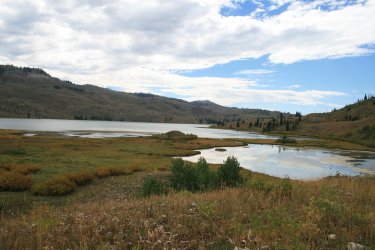
This sounds like a great trip. I have never been up the Box Creek Trail before so I can't comment on that. I have been by Enos Lake before and I wasn't that impressed.

Enos Lake
06.jpg

I actually enjoy the Pacific Creek way into the wilderness, but it can be a mess/slog if the trail is wet, especially the first couple miles. What about starting at Brooks Lake? You could head up Cub Creek then drop over to the South Buffalo Fork. From there, turn right up Lake Creek to Ferry Lake, then take the Woodard Trail down to the Yellowstone River, then on to Hawk's Rest. You'll still see horses on this route, especially near the trailhead, but it's beautiful.
 
This sounds like a great trip. I have never been up the Box Creek Trail before so I can't comment on that. I have been by Enos Lake before and I wasn't that impressed.

Enos Lake
View attachment 141507

I actually enjoy the Pacific Creek way into the wilderness, but it can be a mess/slog if the trail is wet, especially the first couple miles. What about starting at Brooks Lake? You could head up Cub Creek then drop over to the South Buffalo Fork. From there, turn right up Lake Creek to Ferry Lake, then take the Woodard Trail down to the Yellowstone River, then on to Hawk's Rest. You'll still see horses on this route, especially near the trailhead, but it's beautiful.
Gosh, that looks like a fantastic route! I was actually just scrolling through your 2014 report from Enos lake. I agree, based on the pictures, Enos looks cool, albeit somewhat unimpressive. Which seems silly to say, as everything in the GYE is worth a visit at least once, but maybe not worth reworking an itinerary for at this point.

In regard to the Brooks Lake idea (which I hadn't even considered) It looks...long. Here's my dilemma:

I'm a natural history and outdoor filmmaker. I'm filming this trip as part of a larger documentary about the American Model of wildlife conservation. A significant piece in that story will include the restoration work done on Yellowstone cutthroat in Yellowstone lake. If you're not a big fish guy, this point might seem trivial, but the parting of the waters at 2 oceans plateau plays a significant role in species differentiation between Yellowstone, and Snake River Cutthroat, and is likely how inter-basin genetic transfers are able to take place, and a rare location where fish can actually cross a continental divide (in the marshy meadows of the plateau). Its also a really cool landmark in general, and one I'l like to include in the film. I'm trying not to be married to the idea that we have to see two oceans to be able to talk about Yellowstone cutthroat, but it would certainly be ideal.

Now, that being said, Woodard canyon looks insane. Immediately upon setting this itinerary I was already bemoaning the fact that we won't make it higher up drainage to explore some of those canyons. What do you think about the conditions coming over those passes in late June? Looks pretty snowy on satellite. Given how much gear we'll be carrying on this trip, if I can avoid needing specialized snow/ice gear that would be better.
 
The Brooks lake option would add mileage to your trip, and there would definitely be snow in the high country in late June.

Good luck on your documentary. I think you should get Two Ocean Pass in there. I read somewhere that one hypothesis for the Lake Trout in Yellowstone Lake was through Two Ocean Pass instead of someone dumping the Lake Trout in Yellowstone Lake.
 
Enos lake area was burnt bad and has never recovered well... I wouldn't go thru there. Turpin is not that bad... Yes a bunch of outfitters. And flies. East side does not have a bunch.

You could pay an outfitter to haul and drop gear
 
Thanks, Scatman! Might have to save the Brooks Lake route for another a trip. Looks like a great option though.

Interesting theory about the Lake Trout. In my experience it's far more likely to be human negligence, especially when it comes to anglers (for reference I'm a lifelong angler myself). But I'll have to do some digging and see if I can find any info on that theory.

Another question for you, or anyone else in here; do you know of anyone off trailing up to summit Hawks Rest (the actual mountain that separates the upper Yellowstone and Thorofare Creek)? I've got an afternoon currently set aside to try and do it, as I think it'll make for great imagery of the upper Yellowstone/Thorofare area, especially since drones are obviously off limits in the park/wilderness. A few years back I found an old photo of some folks on horses at the top, but I can't find it anymore, and there's no info online about anyone ever hiking up there. I think I can muster a route out of the topography, but it would be cool to hear from anyone who's done it before. Same goes for the "Eye of the Needle" up Cache Creek. Theres one photo from the 70's of somene standing inside the arch, and that's it. We've got a day set aside while camped at 3C3 and plan to try and make it up and traverse the ridge to this rather unique natural arch.
 
Enos lake area was burnt bad and has never recovered well... I wouldn't go thru there. Turpin is not that bad... Yes a bunch of outfitters. And flies. East side does not have a bunch.

You could pay an outfitter to haul and drop gear
Thanks, Bob! Good note about Enos. I think we'll either take Pacific or Turpin. My experience is heavily colored by the rain we had the night before we hiked from Turpin to Soda Fork. 1 to 2 feet of total mud slop for 80% of the trail, and the ruts fill the whole trail and are 4 feet deep in some sections, making it virtually impossible to go around. I think it took us twice as long to get out because we were constantly hugging the edges and leaping side to side to avoid the mud pits. We didn't leave that hike feeling defeated, exactly...but 20+ miles of it with even heavier packs might have done it. I'm sure its a different world when its dry.

When you say "east side" do you just mean the trails to the east of Turpin? Like Pacific, Box Creek etc? and "does not have a bunch" of what? Outfitters? flies? both?

Thanks for the help! I'm rarely one to go around asking for advice on trips like this, I enjoy the DIY spirit, and will suffer with the best of them, but I'm dragging my wife and friends along, and want to make sure I'm not leading anyone into a situation that will jeopardize our larger goals for this trip/project. I want morale to start high, as it'll be a long road ahead to Cooke City. This forum is a wealth of knowledge, so I'm grateful for y'alls expertise.

Oh, and regarding the outfitter route. I think a big part of this story is doing it under our own power. We're all in our late 20s to mid 30's and big backcountry/expedition folks, so we're willing to slog it out. I also like the idea of getting our trail legs in shape early. Somehow I feel like it would be kind of crushing to to have to saddle the packs down after several days of lighter travel. Though I guess that's a reality we won't be able to escape come resupply day ;)
 
Last edited:
Thanks, Scatman! Might have to save the Brooks Lake route for another a trip. Looks like a great option though.

Interesting theory about the Lake Trout. In my experience it's far more likely to be human negligence, especially when it comes to anglers (for reference I'm a lifelong angler myself). But I'll have to do some digging and see if I can find any info on that theory.

Another question for you, or anyone else in here; do you know of anyone off trailing up to summit Hawks Rest (the actual mountain that separates the upper Yellowstone and Thorofare Creek)? I've got an afternoon currently set aside to try and do it, as I think it'll make for great imagery of the upper Yellowstone/Thorofare area, especially since drones are obviously off limits in the park/wilderness. A few years back I found an old photo of some folks on horses at the top, but I can't find it anymore, and there's no info online about anyone ever hiking up there. I think I can muster a route out of the topography, but it would be cool to hear from anyone who's done it before. Same goes for the "Eye of the Needle" up Cache Creek. Theres one photo from the 70's of somene standing inside the arch, and that's it. We've got a day set aside while camped at 3C3 and plan to try and make it up and traverse the ridge to this rather unique natural arch.

Here is the study that I was referring to:

Two Ocean Pass: An Alternative

There is a trail that goes to the top of Hawks Rest. I haven't done it before, but years ago when I was doing a trip into the Thorofare, @Kmatjhwy told me about the trail in case I had time to do it. Unfortunately, I didn't take the time to summit. I'm sure she will be able to tell you where to pick it up when she checks back in.

I have never been to "Eye of the Needle" before. I hope you make it to it and report back to us.
 
Most all of that Pacific creek area burned in 1988 Huck fire, South of the Park burned in 1988 in the Mist fire. Stuff around Enos burned in the Enos fire in 2000. My opinion is that its not very pretty.... I'd go Turpin, its only 15 miles to Two Ocean.

You can get that kind of mud anywhere on any of the trails..... combination of thunderstorms and the soil type. Scat and I had a nice full day of thick mud going out of Brooks.....

Yes, east side........ as in the Yellowstone or the Thorofare drainages. Access from Brooks. Not as many outfitters, less flies cause less horse traffic. Still plenty of mosquitos tho.

Don't know if I buy that hypothesis... I've never seen Lakers in a stream, except for close to the lake they live in.. Plus I would think it would be extremely hard for a fish to travel that way....

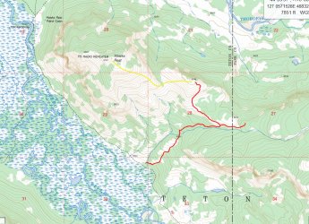
Don't think as trail goes all the way up, pretty sure its a route find on the top half. See pic (red is trail, yellow is easiest area to go up). You can probably route find going East to the Thorofare trail from the (Red) line in the saddle near point 8874.

aa hawk.jpg
 
Last edited:
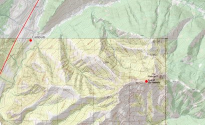
Eye of the Needle area and Cache creek burned in 1988 in the Clover Mist fire, lots of downdead. Some meadows. Never been, never wanted to..... guess you could route find your way up one of the bare ridges....... all about the same.

a needle.jpg
 
Most all of that Pacific creek area burned in 1988 Huck fire, South of the Park burned in 1988 in the Mist fire. Stuff around Enos burned in the Enos fire in 2000. My opinion is that its not very pretty.... I'd go Turpin, its only 15 miles to Two Ocean.

You can get that kind of mud anywhere on any of the trails..... combination of thunderstorms and the soil type. Scat and I had a nice full day of thick mud going out of Brooks.....

Yes, east side........ as in the Yellowstone or the Thorofare drainages. Access from Brooks. Not as many outfitters, less flies cause less horse traffic. Still plenty of mosquitos tho.

Don't know if I buy that hypothesis... I've never seen Lakers in a stream, except for close to the lake they live in.. Plus I would think it would be extremely hard for a fish to travel that way....

Don't think as trail goes all the way up, pretty sure its a route find on the top half. See pic (red is trail, yellow is easiest area to go up). You can probably route find going East to the Thorofare trail from the (Red) line in the saddle near point 8874.

View attachment 141508
Thanks, Bob. That map looks consistent with what I've surmised from other maps and satellite imagery. Theres a faint trail heading up behind the stock site at the base of that drainage but it peters out. Surprising really, it seems to me a quick summit of Hawks Rest would be popular amongst hikers to the Thorofare. Certainly appeals to me, but maybe I'll feel different once I'm actually there. Site availability depending, we'll likely try and camp near the start of that short trail, so it would be a relatively easy jaunt with a day pack. We'll See!

Really interesting read about the Lakers. I was ready to poohpooh it as well, but the study seems to have a good basis for the theory. eDNA has proven and accurate tool, and while they acknowledge further study needs to be done, it certainly showed lake trout DNA present in Pacific Creek. And while I agree with you Bob it's highly unusual to see Lakers in river/stream habitat in the rockies, it's quite common for their life histories farther north. Lakers prefer really cold water, hence being deep water adapted in Jackson and Yellowstone Lakes, but up in the arctic where their most prevalent they occupy a wide range of habitats, from shallow lakes to large rivers and small streams. Essentially as they mentioned in the study, it's *plausible* that the lakers could transfer at two oceans if they got moving during early season high water events. We know for a fact that's how Yellowstone Cutthroat got there several million years ago, so, its in the realm as they say... I hope they follow up with more research. Either way, lake trout were introduced to the Snake drainage intentionally as well, so whichever way they got to Yellowstone Lake it's still our fault, ha!
 
  • Like
Reactions: Bob
Eye of the Needle area and Cache creek burned in 1988 in the Clover Mist fire, lots of downdead. Some meadows. Never been, never wanted to..... guess you could route find your way up one of the bare ridges....... all about the same.

View attachment 141509
Yeah we have C3C booked (The campsite on the map) and a zero day planned at it. I think it'll be too tempting to pass up. Having spent a lot of time hiking to arches in the Southwest, it just too enticing to find one in such an unexpected place. We'll have the benefit of weight left behind at camp on the pole, so the standing dead shouldn't be too much of a hassle with lighter packs.
 
Thanks, Bob. That map looks consistent with what I've surmised from other maps and satellite imagery. Theres a faint trail heading up behind the stock site at the base of that drainage but it peters out. Surprising really, it seems to me a quick summit of Hawks Rest would be popular amongst hikers to the Thorofare. Certainly appeals to me, but maybe I'll feel different once I'm actually there. Site availability depending, we'll likely try and camp near the start of that short trail, so it would be a relatively easy jaunt with a day pack. We'll See!
I haven't been up it, I just have the trail located ......... I am not one to climb to a high point for the heck of it.....
 
I haven't been up it, I just have the trail located ......... I am not one to climb to a high point for the heck of it.....
Ha! Fair enough, but something tells me we might have different definitions of "the heck of it"! As a cinematographer/photographer, I find I'm rarely disappointed by a high point, though, it's happened. I have a feeling the scenery in the upper Yellowstone will make it worth my while though.
 
  • Like
Reactions: Bob
Another nice spot would be Yellowstone Point, Southwest across the Yellowstone River from Hawks Rest. Just east of Two Ocean on Atlantic Creek. If you want to tuff it, you can climb a finger of the Trident (on a old Ranger horse trail) to whats called Overlook Point where they used to go to scan for poachers, its just East of the Thorofare Ranger station.

Also if you want waterfalls there are nice ones on Cliff Creek, north and east of the Thorofare Range Station and Falcon Creek west of the Thorofare Ranger station by the South Boundary trail. You'll be in the area.

There is a minor thermal area in Brimstone Basin off the trail as you are near the Lake.
 
Last edited:

Don't like ads? Become a BCP Supporting Member and kiss them all goodbye. Click here for more info.

Back
Top