balzaccom
Member
- Joined
- Sep 30, 2014
- Messages
- 898
With M's foot slowly recovering from tendonitis, we decided to push our luck a bit and take a hike out of Bishop via the South Lake trailhead. The weather was windy as heck (up to 70mph over the passes) on Wednesday, but those winds were supposed to die down on Thursday morning. 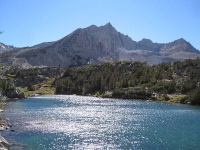 Or not. We picked up our permit for the trail into Dusy Basin at the Mono Lake office with no trouble, and had plenty of choices for a campsite at the Willow CG below South Lake. Everything was perfect. But the next day the wind continued to blow hard. We took it slowly up towards Bishop Pass, hoping the wind would ease off in the afternoon.
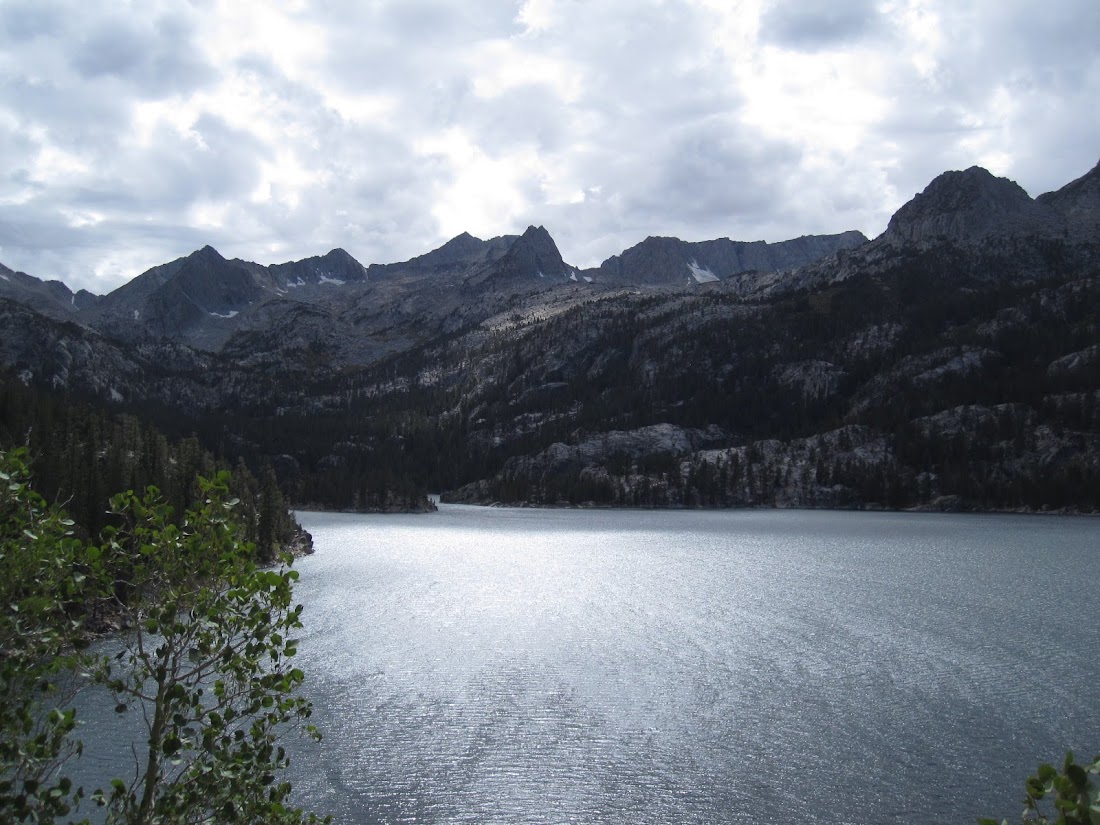
But by the time we stopped for lunch at Saddlerock Lake, it was blowing harder than ever. And so after lunch we dropped back down below into Timberline Tarns and looked for a campsite. We figured that we could hide out for the afternoon, and give it a new shot in the morning. The people we had met on the trail coming down from Bishop Pass looked shell-shocked by the experience, and told of really difficult conditions. Some had hiked from Happy Isles or Whitney and said that Bishop Pass was the worst experience of their hike.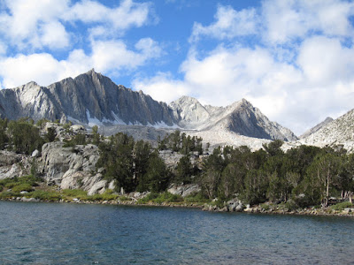 With a few days worth of food in our bear can, we thought it made sense to wait a day and let the weather improve. We had a nice exploration of the two Timberline Tarns in the afternoon--this is spectacular country. Late in the afternoon we stuck our head up again into Saddlerock Lake and got our hats blown off. That evening the temperature dropped to the low 40s, and with the wind it was chilly. We were in our tent by 7:30, snug in our bags. At least we were prepared with the right gear.
That night the wind howled and gusted, and the temperature dropped to right around freezing. By the next day, the wind was still blowing hard, and clouds were moving in. We did not like the idea of going up over the pass, and so we headed back towards Ruwua and Chocolate Lakes, hoping that they would be more sheltered.
The trail from Long to Ruwau Lake is really steep, and Ruwau is nestled in a dramatic granite bowl at the base of Cloudripper Peak. That was hard work But once we checked it out, we decided to continue on over the use trail to Chocolate Lakes. Our topo map showed a trail. It was optimistic, and made us reconsider what steep means. Straight up and straight down. M's foot was holding up, but barely.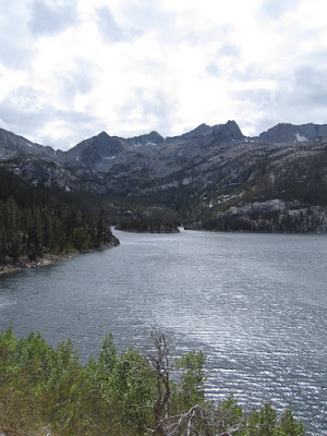 Chocolate Lakes are gorgeous. We really liked the middle lake best for camping. We thought about that, but the wind was still knocking us around, and it was still before noon. Maybe Bull Lake would be better.
We ate lunch there in the shelter of some trees on the east side, but the gusts of wind blowing our food around convinced us that it was time to give up. As the great cyclist Eddy Merckx once said, "the hills are hard, but wind is the master." And on this trip, the wind was winning.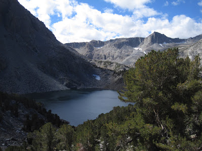 On the way back down the trail we ran into quite a few groups heading in for the weekend. We were surprised to learn that none if them could tell us what the current weather forecast was. Amazing. I hope they were prepared for temps in the 30s and 30 mph winds...gusts to 50+. We were, and we still felt the conditions were not enough fun for us to continue.
We also met a young guy who was literally running up the trail early in the day up by our campsite. We laughed with him and at him as he jogged by. Later the same day we saw him jogging back down, nearly done with his hike. It turned out he had promised a friend to carry a resupply load up into Dusy Basin. And he was seeing how quickly he could run the route, God bless him. He was still laughing as he jogged off down the trail.
That night we slept back in the van in Willow campground. The wind shivered and shook the aspens all night long, and then next morning we drive into Bishop for a warm cooked breakfast. That settled it. We were going to the cabin, not back up into the wind. The wind blew hard all the way over Sonora Pass, and the deer hunters there must have spent a memorable and cold night waiting for dawn.
The rest of the photos are here: https://photos.app.goo.gl/c7fFMevdGy1sCUZBA
Or not. We picked up our permit for the trail into Dusy Basin at the Mono Lake office with no trouble, and had plenty of choices for a campsite at the Willow CG below South Lake. Everything was perfect. But the next day the wind continued to blow hard. We took it slowly up towards Bishop Pass, hoping the wind would ease off in the afternoon. But by the time we stopped for lunch at Saddlerock Lake, it was blowing harder than ever. And so after lunch we dropped back down below into Timberline Tarns and looked for a campsite. We figured that we could hide out for the afternoon, and give it a new shot in the morning. The people we had met on the trail coming down from Bishop Pass looked shell-shocked by the experience, and told of really difficult conditions. Some had hiked from Happy Isles or Whitney and said that Bishop Pass was the worst experience of their hike.
With a few days worth of food in our bear can, we thought it made sense to wait a day and let the weather improve. We had a nice exploration of the two Timberline Tarns in the afternoon--this is spectacular country. Late in the afternoon we stuck our head up again into Saddlerock Lake and got our hats blown off. That evening the temperature dropped to the low 40s, and with the wind it was chilly. We were in our tent by 7:30, snug in our bags. At least we were prepared with the right gear. That night the wind howled and gusted, and the temperature dropped to right around freezing. By the next day, the wind was still blowing hard, and clouds were moving in. We did not like the idea of going up over the pass, and so we headed back towards Ruwua and Chocolate Lakes, hoping that they would be more sheltered.
The trail from Long to Ruwau Lake is really steep, and Ruwau is nestled in a dramatic granite bowl at the base of Cloudripper Peak. That was hard work But once we checked it out, we decided to continue on over the use trail to Chocolate Lakes. Our topo map showed a trail. It was optimistic, and made us reconsider what steep means. Straight up and straight down. M's foot was holding up, but barely.
Chocolate Lakes are gorgeous. We really liked the middle lake best for camping. We thought about that, but the wind was still knocking us around, and it was still before noon. Maybe Bull Lake would be better.We ate lunch there in the shelter of some trees on the east side, but the gusts of wind blowing our food around convinced us that it was time to give up. As the great cyclist Eddy Merckx once said, "the hills are hard, but wind is the master." And on this trip, the wind was winning.
On the way back down the trail we ran into quite a few groups heading in for the weekend. We were surprised to learn that none if them could tell us what the current weather forecast was. Amazing. I hope they were prepared for temps in the 30s and 30 mph winds...gusts to 50+. We were, and we still felt the conditions were not enough fun for us to continue. We also met a young guy who was literally running up the trail early in the day up by our campsite. We laughed with him and at him as he jogged by. Later the same day we saw him jogging back down, nearly done with his hike. It turned out he had promised a friend to carry a resupply load up into Dusy Basin. And he was seeing how quickly he could run the route, God bless him. He was still laughing as he jogged off down the trail.
That night we slept back in the van in Willow campground. The wind shivered and shook the aspens all night long, and then next morning we drive into Bishop for a warm cooked breakfast. That settled it. We were going to the cabin, not back up into the wind. The wind blew hard all the way over Sonora Pass, and the deer hunters there must have spent a memorable and cold night waiting for dawn.
The rest of the photos are here: https://photos.app.goo.gl/c7fFMevdGy1sCUZBA