Ben
Member
- Joined
- Sep 12, 2014
- Messages
- 1,873
As i've mentioned in a couple reports i have a hard time waiting for snow to melt to go backpacking. So i ended up venturing into the Sawtooths in june, to see what was going on up there. I actually left may 30. It was a relatively uneventful trip, but i learned some things.
I drove up to the Grandjean trail head, because it's only just over two hours from my house. I've done a fair bit of hiking from there. I opted to follow the South Fork Payette River Trail because it stays at a lower elevations. The short version of this trip report though is that the trail is long and flat. Gently rising actually. If you want, you can keep reading for the minor details.
The South Fork Payette bends it's way up right into the southern part of the Sawtooths. It goes for about 17 miles before it really gets any where, in my opinion. I didn't go that far though. I got to the trail head late, after dark actually, and just tried to get a little ways in. I knew the start of the trail pretty well. About 1.5 miles in i forded Baron Creek in the dark. This was an experience. I'd never done any thing like this before, and here i was at eleven pm first timing it. It wasn't every scary, but it was intense. Spring flows, the water was high and fast enough that i got my crotch wet. The rocks on the bottom were difficult footing, with all the water pushing at your thighs. But i made it. And then crossed three more branches of Baron Creek, but these were all much less substantial. I camped not too much farther along, between Baron and Goat Creeks.
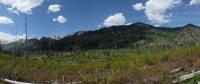
 Here's Isaac the next morning. He wanted out of the tent earlier than i was ready to get up, and just kind of chilled out there. The weather was nice. There was a 30% chance of rain that never materialized as any thing of consequence. Here you can see the South Fork Payette River valley. I think there was a fire here several years before, leading to the open views. Lots of short trees.
 Before long we came to Goat Creek, not too far from where we camped. Here there was a nice log crossing, but Isaac was skeptical of such, and after short deliberation chose to swim across it in stead.
.jpg") He's got heart.
He's got heart. The creek's as deep as he is tall in the center. And Baron was even deeper the night before.
 Here's a dry branch of Goat Creek. Goat Creek also features in a more interesting trip that i'll have to report later.
 General trail conditions.
Here you can see the river pooling in Big Meadows. That's what it's called. The valley's considerably broader here than it is farther up or farther down.
 It meanders for a few miles like this.
And then there was this guy.
I suppose the river winding it's slow path didn't go on for as long as it felt like it did, but i didn't get much out of that stretch. Eventually though there were bits like these where the river was moving faster, and a lot more down. The high flow was really impressive just pouring down the mountain. I enjoyed this a little more. A small falls.
 And below it.
 And the whole thing.
Fern Falls. Ferns all over the place to the left of it.
Around 6500' there began to be patches of lingering snow. Around 7000' snow would cover the trail pretty consistently, but that was later. The trail head starts at 5200.


Trail conditions farther along.

For some reason i didn't manage to get a better picture of this. I should've. This is where i turned back. The trail crosses the South Fork Payette four times, and this is the first. You should be able to make out the nothing but snow on the far side. Little incentive to wade a very swift, waist deep channel..jpg") Isaac was happy to be going back. His feet might've been cold.
Isaac was happy to be going back. His feet might've been cold.

Random fungus up above the first patches of snow.
The point at which i turned around was at about 13 miles from the trail head. I back tracked and camped at Elk Lake which i had passed earlier. About 11 miles from the trail head. The next morning, before returning home, i explored around there some. It was interesting. This is a marsh just above the lake. And where the marsh transitions.

Next to where i camped was a pretty nice water fall.
So i climbed to the top of it.


I think it was Drop Creek. There were some good views from up there.
 The view of the lake was the most interesting, and really the high light of getting out that week end at all. I'd never seen any thing like it.
I imagine that the green line is the path of the river channel into the lake. Like an inundated delta with the high water of spring. Sediment settles out along the edges, but the continual in flow of the river keeps the channel clear..jpg") So that was elk lake. Glad that i saw it. But i haven't felt any reason to head back there since. No idea when i would. Seeing the high flows of the river was really cool also though. And if you're looking for an easy trail, this was it, just the ford of Baron Creek. Which wouldn't be near so bad in proper season.
So that was elk lake. Glad that i saw it. But i haven't felt any reason to head back there since. No idea when i would. Seeing the high flows of the river was really cool also though. And if you're looking for an easy trail, this was it, just the ford of Baron Creek. Which wouldn't be near so bad in proper season.
And i'll leave you with this.
peace
I drove up to the Grandjean trail head, because it's only just over two hours from my house. I've done a fair bit of hiking from there. I opted to follow the South Fork Payette River Trail because it stays at a lower elevations. The short version of this trip report though is that the trail is long and flat. Gently rising actually. If you want, you can keep reading for the minor details.
The South Fork Payette bends it's way up right into the southern part of the Sawtooths. It goes for about 17 miles before it really gets any where, in my opinion. I didn't go that far though. I got to the trail head late, after dark actually, and just tried to get a little ways in. I knew the start of the trail pretty well. About 1.5 miles in i forded Baron Creek in the dark. This was an experience. I'd never done any thing like this before, and here i was at eleven pm first timing it. It wasn't every scary, but it was intense. Spring flows, the water was high and fast enough that i got my crotch wet. The rocks on the bottom were difficult footing, with all the water pushing at your thighs. But i made it. And then crossed three more branches of Baron Creek, but these were all much less substantial. I camped not too much farther along, between Baron and Goat Creeks.
Here's Isaac the next morning. He wanted out of the tent earlier than i was ready to get up, and just kind of chilled out there. The weather was nice. There was a 30% chance of rain that never materialized as any thing of consequence. Here you can see the South Fork Payette River valley. I think there was a fire here several years before, leading to the open views. Lots of short trees. Before long we came to Goat Creek, not too far from where we camped. Here there was a nice log crossing, but Isaac was skeptical of such, and after short deliberation chose to swim across it in stead. He's got heart. The creek's as deep as he is tall in the center. And Baron was even deeper the night before. Here's a dry branch of Goat Creek. Goat Creek also features in a more interesting trip that i'll have to report later. General trail conditions.Here you can see the river pooling in Big Meadows. That's what it's called. The valley's considerably broader here than it is farther up or farther down.
It meanders for a few miles like this.And then there was this guy.
I suppose the river winding it's slow path didn't go on for as long as it felt like it did, but i didn't get much out of that stretch. Eventually though there were bits like these where the river was moving faster, and a lot more down. The high flow was really impressive just pouring down the mountain. I enjoyed this a little more.
A small falls. And below it. And the whole thing.Fern Falls. Ferns all over the place to the left of it.
Around 6500' there began to be patches of lingering snow. Around 7000' snow would cover the trail pretty consistently, but that was later. The trail head starts at 5200.
Trail conditions farther along.
For some reason i didn't manage to get a better picture of this. I should've. This is where i turned back. The trail crosses the South Fork Payette four times, and this is the first. You should be able to make out the nothing but snow on the far side. Little incentive to wade a very swift, waist deep channel.
Isaac was happy to be going back. His feet might've been cold. Random fungus up above the first patches of snow.
The point at which i turned around was at about 13 miles from the trail head. I back tracked and camped at Elk Lake which i had passed earlier. About 11 miles from the trail head. The next morning, before returning home, i explored around there some. It was interesting. This is a marsh just above the lake.
And where the marsh transitions. Next to where i camped was a pretty nice water fall.
So i climbed to the top of it.
I think it was Drop Creek. There were some good views from up there.
The view of the lake was the most interesting, and really the high light of getting out that week end at all. I'd never seen any thing like it. I imagine that the green line is the path of the river channel into the lake. Like an inundated delta with the high water of spring. Sediment settles out along the edges, but the continual in flow of the river keeps the channel clear.
So that was elk lake. Glad that i saw it. But i haven't felt any reason to head back there since. No idea when i would. Seeing the high flows of the river was really cool also though. And if you're looking for an easy trail, this was it, just the ford of Baron Creek. Which wouldn't be near so bad in proper season.And i'll leave you with this.
peace
Attachments
Last edited: