- Joined
- Dec 7, 2017
- Messages
- 264
November 6 - November 9, 2019
While organizing our photos from this trip, I realized this was the fourth time Blake and I had been in the far southeastern portion of Utah in 2019. And I can say it was probably our favorite. While we did get in one well-established hike (Lower Fish Creek), all the others were either to places that we only knew from archaeology reports (which, understandably, don't always tell the reader what to expect to see and certainly don't offer any details on the hike itself) or to sites that a friend or a "friend of a friend of a friend" knew about. So, while we had sorted out the general locations of our desired destinations, we were flying by the seat of our pants much of the time with no downloaded tracks nor detailed intel. Not our usual style, but it turned out to be a lot of fun!
Our first hike was to a couple of tower complexes on Cedar Mesa. While it's not definitively known what function(s) the towers served, it's interesting to contemplate that they might have been used as watchtowers over critical resources (such as a spring) or as markers upon the landscape.
Blake looking down into a canyon over which one tower complex is situated:

The remaining walls of two of the towers:


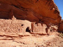
A ruin situated below the towers above:

Not too far away from the first group of towers is a smaller cluster of towers with one being more intact than the others:

The following day we hiked up Lower Fish Creek off of Comb Wash. It was a beautiful day for hiking and we had the canyon entirely to ourselves (or so we thought!).
Here's what is often referred to as the First Ruin and one of its associated pictographs:


Some odd, fluffy vegetation we encountered during the hike that looked like wheat-colored fog rising from the creek bed:

Blake atop the second significant ruin as we worked our way up the canyon:

Astonishingly well-preserved reverse handprints at the second ruin site:

We were nearing our turn-around time after spending much of the day scrambling up and down the slickrock (you never know what you might find hidden in some nook), but decided to give ourselves 15 more minutes to poke around a side canyon. Glad we did!
A seemingly inaccessible ruin and horse-collar granary:


And just a short way further up the side canyon another ruin that could only be accessed with a very tall ladder or a top rope:

From there we turned around and headed for the truck. As usual, Blake was ahead of me by about 25 or 30 yards and it was he that probably stirred the other visitor in Fish Creek. I heard what I thought was some sort of buzzing insect. But, no, that wasn't quite right. I stopped in my tracks (as I tell our friends and family to do in the same situation) and listened. Sure enough, it was a rattler under a bush to my immediate left. I hollered for Blake to hurry back to get a look, which he did, but for some lame reason he wouldn't pull back the branches of the shrub so that I could get a good pic. Jeez!
Look closely:

As an aside....While down at Phantom Ranch a few years ago we attended a ranger talk about rattlesnakes in the Big Ditch. She asked the audience to come up with the three most common factors related to a snake bite. Answer? Males aged 19 - 25, beer, and a woman they're trying to impress.
Day Three of our adventure took us to an intriguing site about which I found little information as to the structure itself, but knew it to be built into a natural, vertical crack in a cliff face. A kind friend provided a waypoint and a San Juan resident offered the advice of "be extra careful of that floor as I hear it's starting to give way". We drove to the general area, donned puffy coats to ward against the cold while in the crack, and headlamps. A short time later we found surface rooms and a nearby break in the sandstone. Blake dropped down in first, then me. It was cramped and we could see that the "floor" was made of smallish logs spanning the crack with stones on top. In the middle of the floor was a square hole through which I might've been able to squeeze through, but probably not Blake. Blake went up top to find another possible entry while I fretted about putting any weight on the beam-and-stone floor. I peered as best I could down the hole and it looked like the second landing was at least 20 feet down. In the end I didn't get up the nerve to get closer to the square access hole and (with the prior day's snake in the back of my mind) declared that the place was freakin' me out. Maybe we'd be willing to give it another shot if we could go with someone who's already been in there and that knew of the second entry point. Or not.
Walls of the surface rooms:

The stonework filling in the face of the crack:

A view out the window overlooking the canyon:

A look down into the chamber with the square hole:

Glad, but frustrated, to get out of the crack we focused our attention on rock art over in Montezuma Canyon. What is believed to be a pair of macaws (in the upper portion of the photo). Difficult to see, let alone photograph, in direct sunlight:

Spiral-Head:

Big Horn Sheep or Stylized Canines?:

The grand finale for the day was a large ruin site a friend had shown us on sat imagery. Arranged across the hilltop site and at its base there appeared to be no less than 40 rooms and pit structures. Most fascinating, though, were the 12 tall stones erected in a line, supposedly to mark the passing of the months. Blake and I separately wondered why it would be important for the ancient inhabitants of the site to know that one month had ended and another had begun. Ceremonial reasons? For more practical reasons related to agriculture?
The row of stones (some over 6 feet tall), some of which were toppled over, as seen from above:

As seen from the ground:

Checking out the site was a wonderful way to end the day, especially after a somewhat creepy beginning.
Our next and final day wasn't planned out. We both wanted to get in a strong hike, Blake requesting that it not involve the sandy slogfest of Lower Fish Creek and I wanting to do some off-trail exploring. A friend of ours had once suggested that ruins could be found in a cluster of side canyons east of Comb Ridge, but to which he'd not been himself. I knew there was also a very large, south-facing alcove in that general area that I'd had my eyes on for the better part of a year. Only thing about that alcove is that it's entrance is obscured by several tall pinyons.
Still not certain about what we wanted to do (the possibilities are endless in that part of the world!), at the last second I instructed Blake to hang a right onto the road to that big alcove. We parked, consulted our map to sort out the best approach, geared up and took off. Two attempts to get into the drainage were fruitless with either a sudden pouroff (for which we'd need a 50-foot rope), or a very long, steep, and loose slide on our derrieres. But (!) along the way we did spot another alcove in the distance that had perfectly broken, square "rocks" within. A quick look through the binos confirmed our suspicions. With that we abandoned thoughts of getting to the pinyon-y alcove, checked the map again, and headed to the more promising site.
As before, Blake (and his long legs) was in the lead, with me constantly checking the ground for sherds and points. I almost bumped into him at one point where he was standing perfectly still. I assumed he was watching an avian friend and whispered "what do you see?". "Come see for yourself"
His finding:

In the immediate vicinity were the outlines of room blocks:

I lingered behind (again looking at pieces of pottery and worked stone) while Blake continued on. Eventually I moved on to follow Blake when he told me to instead move further to my right. A few steps away was a wooden structure that I'm not sure what to make of. It looked to have once been a ramada, but from what era? I find it hard to believe it was contemporaneous with the nearby mano and metate.
Partially collapsed ramada:

Broken manos by the ramada:
From there we quickly dropped down into the bottom of the drainage and began some serious bushwhacking. Blake took one approach, I another, he getting to the base of the alcove before me. He exclaimed his complete befuddlement, however, in that the cliff dwelling we'd seen with the binso had somehow disappeared. We couldn't possibly be in the wrong drainage or at the wrong alcove, could we? No way! That big vertical stain of varnish was exactly as we saw it from above. What the heck?! We pushed on, just to make sure, but felt deflated. You can imagine our utter pleasure when we realized that we simply couldn't see the structure through the tangle of overgrowth in front of it. Yes!
The alcove held a little of everything. A dwelling with an adjacent kiva:

Grinding slicks:

Sharpening grooves:

Corn cobs:

Sherds:

Worked stone:

And pictos:

A fine way to end our adventure!
While organizing our photos from this trip, I realized this was the fourth time Blake and I had been in the far southeastern portion of Utah in 2019. And I can say it was probably our favorite. While we did get in one well-established hike (Lower Fish Creek), all the others were either to places that we only knew from archaeology reports (which, understandably, don't always tell the reader what to expect to see and certainly don't offer any details on the hike itself) or to sites that a friend or a "friend of a friend of a friend" knew about. So, while we had sorted out the general locations of our desired destinations, we were flying by the seat of our pants much of the time with no downloaded tracks nor detailed intel. Not our usual style, but it turned out to be a lot of fun!
Our first hike was to a couple of tower complexes on Cedar Mesa. While it's not definitively known what function(s) the towers served, it's interesting to contemplate that they might have been used as watchtowers over critical resources (such as a spring) or as markers upon the landscape.
Blake looking down into a canyon over which one tower complex is situated:
The remaining walls of two of the towers:
A ruin situated below the towers above:
Not too far away from the first group of towers is a smaller cluster of towers with one being more intact than the others:
The following day we hiked up Lower Fish Creek off of Comb Wash. It was a beautiful day for hiking and we had the canyon entirely to ourselves (or so we thought!).
Here's what is often referred to as the First Ruin and one of its associated pictographs:
Some odd, fluffy vegetation we encountered during the hike that looked like wheat-colored fog rising from the creek bed:
Blake atop the second significant ruin as we worked our way up the canyon:
Astonishingly well-preserved reverse handprints at the second ruin site:
We were nearing our turn-around time after spending much of the day scrambling up and down the slickrock (you never know what you might find hidden in some nook), but decided to give ourselves 15 more minutes to poke around a side canyon. Glad we did!
A seemingly inaccessible ruin and horse-collar granary:
And just a short way further up the side canyon another ruin that could only be accessed with a very tall ladder or a top rope:
From there we turned around and headed for the truck. As usual, Blake was ahead of me by about 25 or 30 yards and it was he that probably stirred the other visitor in Fish Creek. I heard what I thought was some sort of buzzing insect. But, no, that wasn't quite right. I stopped in my tracks (as I tell our friends and family to do in the same situation) and listened. Sure enough, it was a rattler under a bush to my immediate left. I hollered for Blake to hurry back to get a look, which he did, but for some lame reason he wouldn't pull back the branches of the shrub so that I could get a good pic. Jeez!
Look closely:
As an aside....While down at Phantom Ranch a few years ago we attended a ranger talk about rattlesnakes in the Big Ditch. She asked the audience to come up with the three most common factors related to a snake bite. Answer? Males aged 19 - 25, beer, and a woman they're trying to impress.
Day Three of our adventure took us to an intriguing site about which I found little information as to the structure itself, but knew it to be built into a natural, vertical crack in a cliff face. A kind friend provided a waypoint and a San Juan resident offered the advice of "be extra careful of that floor as I hear it's starting to give way". We drove to the general area, donned puffy coats to ward against the cold while in the crack, and headlamps. A short time later we found surface rooms and a nearby break in the sandstone. Blake dropped down in first, then me. It was cramped and we could see that the "floor" was made of smallish logs spanning the crack with stones on top. In the middle of the floor was a square hole through which I might've been able to squeeze through, but probably not Blake. Blake went up top to find another possible entry while I fretted about putting any weight on the beam-and-stone floor. I peered as best I could down the hole and it looked like the second landing was at least 20 feet down. In the end I didn't get up the nerve to get closer to the square access hole and (with the prior day's snake in the back of my mind) declared that the place was freakin' me out. Maybe we'd be willing to give it another shot if we could go with someone who's already been in there and that knew of the second entry point. Or not.
Walls of the surface rooms:
The stonework filling in the face of the crack:
A view out the window overlooking the canyon:
A look down into the chamber with the square hole:
Glad, but frustrated, to get out of the crack we focused our attention on rock art over in Montezuma Canyon. What is believed to be a pair of macaws (in the upper portion of the photo). Difficult to see, let alone photograph, in direct sunlight:
Spiral-Head:
Big Horn Sheep or Stylized Canines?:
The grand finale for the day was a large ruin site a friend had shown us on sat imagery. Arranged across the hilltop site and at its base there appeared to be no less than 40 rooms and pit structures. Most fascinating, though, were the 12 tall stones erected in a line, supposedly to mark the passing of the months. Blake and I separately wondered why it would be important for the ancient inhabitants of the site to know that one month had ended and another had begun. Ceremonial reasons? For more practical reasons related to agriculture?
The row of stones (some over 6 feet tall), some of which were toppled over, as seen from above:
As seen from the ground:
Checking out the site was a wonderful way to end the day, especially after a somewhat creepy beginning.
Our next and final day wasn't planned out. We both wanted to get in a strong hike, Blake requesting that it not involve the sandy slogfest of Lower Fish Creek and I wanting to do some off-trail exploring. A friend of ours had once suggested that ruins could be found in a cluster of side canyons east of Comb Ridge, but to which he'd not been himself. I knew there was also a very large, south-facing alcove in that general area that I'd had my eyes on for the better part of a year. Only thing about that alcove is that it's entrance is obscured by several tall pinyons.
Still not certain about what we wanted to do (the possibilities are endless in that part of the world!), at the last second I instructed Blake to hang a right onto the road to that big alcove. We parked, consulted our map to sort out the best approach, geared up and took off. Two attempts to get into the drainage were fruitless with either a sudden pouroff (for which we'd need a 50-foot rope), or a very long, steep, and loose slide on our derrieres. But (!) along the way we did spot another alcove in the distance that had perfectly broken, square "rocks" within. A quick look through the binos confirmed our suspicions. With that we abandoned thoughts of getting to the pinyon-y alcove, checked the map again, and headed to the more promising site.
As before, Blake (and his long legs) was in the lead, with me constantly checking the ground for sherds and points. I almost bumped into him at one point where he was standing perfectly still. I assumed he was watching an avian friend and whispered "what do you see?". "Come see for yourself"
His finding:
In the immediate vicinity were the outlines of room blocks:
I lingered behind (again looking at pieces of pottery and worked stone) while Blake continued on. Eventually I moved on to follow Blake when he told me to instead move further to my right. A few steps away was a wooden structure that I'm not sure what to make of. It looked to have once been a ramada, but from what era? I find it hard to believe it was contemporaneous with the nearby mano and metate.
Partially collapsed ramada:
Broken manos by the ramada:
From there we quickly dropped down into the bottom of the drainage and began some serious bushwhacking. Blake took one approach, I another, he getting to the base of the alcove before me. He exclaimed his complete befuddlement, however, in that the cliff dwelling we'd seen with the binso had somehow disappeared. We couldn't possibly be in the wrong drainage or at the wrong alcove, could we? No way! That big vertical stain of varnish was exactly as we saw it from above. What the heck?! We pushed on, just to make sure, but felt deflated. You can imagine our utter pleasure when we realized that we simply couldn't see the structure through the tangle of overgrowth in front of it. Yes!
The alcove held a little of everything. A dwelling with an adjacent kiva:
Grinding slicks:
Sharpening grooves:
Corn cobs:
Sherds:
Worked stone:
And pictos:
A fine way to end our adventure!
Attachments
Last edited: