Sawtooths Advice (July 2018)

khodiak

New Member
Joined
May 11, 2018
Messages
4
Hi all -

I'm heading into the Sawtooths for the first time with 5 friends in late July. We're planning a 5 night trip.

I've put together a tentative itinerary based on the great trip reports and advice on this site. I've pasted the itinerary below. However, some of my buddies are keen on having fires at night, and the itinerary below is in a no fire area.

I was wondering if anyone could give me some pointers to other areas that would give us an equivalent trip (i.e. lakes every night), but in an area that allows fires. Thanks in advance and let me know if you have any questions.

And of course, please let me know if you would make any alterations to the current itinerary.

  • Day 1: Tin Cup Trailhead to Farley Lake (4.79mi)
  • Day 2: Farley Lake to Imogene Lake (5.09mi)
  • Day 3: Imogene Lake to Hidden Lake (8.28mi)
  • Day 4: Hidden Lake to Toxaway Lake (6.62mi)
  • Day 5: Toxaway Lake to Alice Lake (4.61mi)
  • Day 6: Alice Lake to Tin Cup Trailhead (4.61mi)
Click here to view on CalTopo
 
That's a good trip along a very popular loop.
As for fires, even if you go to locations where fires are permitted, they are only allowed on a fire blanket or fire pan.
Other options are around Redfish Lake or in the White Clouds.
 
Oh ya...you could also have a strict fire ban in place for the entire region for the months of July and August. And those are quite common every summer.
 
Your route is very nice and the scenery can't be beat. Imogene and Alice lakes are two of my favorites.
As @Parma said, don't expect solitude on these trails, and there are no areas in the Sawtooths where open fires are allowed without restriction. Late July it will stay light until 9 or after and likely be very warm, so you really wouldn't need a fire anyway.
You might check out the Boulder Chain Lakes and Big Boulder Lakes in the Whiteclouds.
Other suggestions in the general geographic area would be the Bighorn Crags near Salmon or the Eagle's Nest Wilderness lakes area in NE Oregon.
 
Oh ya...you could also have a strict fire ban in place for the entire region for the months of July and August. And those are quite common every summer.
Good chance fire restrictions this year ..... As said
 
Thanks everyone! We have all come to terms with not having any fires. I'm sure the views will be worth it :)

I'm a little bummed about the potential lack of solitude. I suspect it is for good reason -- beautiful scenery that can't be beat. Are any of the locations you all have suggested less traveled?

By the way, I've been using this link to monitor the weather but I was wondering if you prefer other resources: https://www.mountain-forecast.com/peaks/Mount-Cramer/forecasts/2500

I have read that historically, there have been cases with legitimate snow pack even in mid July. Are there any resources for us to monitor the conditions? We don't have the appropriate gear (microspikes or ice axes) right now. We were planning on monitoring the conditions and gearing up if necessary.
 
Plenty of solitude and few people......but not on your proposed route
 
I found solitude on that route, If you send me a pm I can show you on a map where I camped and had the place to myself.
 
Sawtooths didn't have an over abundant snow year. You'll encounter some snow but not likely you'll need spikes or axes.
 
  • Like
Reactions: Ben
I hate to be a wet blanket, but pretty much everywhere in the west is under some sort of fire restrictions at some point most years. And even when fire bans aren't in place, it's often a bad idea to build them anyway (stripping the area of wood, soil acidification, not to mention fire danger). In the arid west, I personally save the fires for developed car campgrounds where there are fewer combustibles and dedicated fire pits.
 
@Bob - could you point me to a general area that you would target for more solitude?

Thanks everyone for your input.
 
Goat lake. Fishhook Creek area. Three island lake area. Lake kathyn, upper redfish. Packrat, warbonnet. Lakes west of alturus ... I think it's Alpine basin and the basin to the west of them. Most of what I mention requires some off trail... some are strenuoussbut most arent really too bad in sawtooths but be aware of your limits....and basically NO fires at nightnight anywhere.
 
By the way, I've been using this link to monitor the weather but I was wondering if you prefer other resources: https://www.mountain-forecast.com/peaks/Mount-Cramer/forecasts/2500

In my experience mountain-forecast is guesswork with fancy charts. I don't know how they come up with some of the forecasts for more remote peaks that don't have weather stations parked on them, but more often than not I've seen those forecasts prove wrong.

Colorado has the avalanche information center page which provides point/zone forecasts and they've been much more accurate in my experience. I don't know if there's an equivalent for Idaho.

But really just checking any weather site 2-3 days beforehand should give you a decent idea of what to expect, along with understanding what to expect with typical mountain weather during the summer.
 
http://www.nws.noaa.gov/wtf/udaf/area/

Use this, it lets you draw an area to get a forecast for. It's pretty accurate, at least as much as any weather forecast can be accurate.

Most weather forecasts just pull the noaa data anyway for their forecasts, so might as well go to the source.
 
Hi all -- just wanted to check in and ask if anyone has been out in this area recently. How is the snow pack? Do we need to plan on bringing any extra gear?
 
Hi all -- just wanted to check in and ask if anyone has been out in this area recently. How is the snow pack? Do we need to plan on bringing any extra gear?

You can go to sawtoothcamera.com to see a webcam pointed at the range. Caltopo.com also has options for recent satellite overlays, but they're often ruined by clouds. You should be fine in July though.
 
Also mesowest has local raws stations
 
A friend just came back from a trip this week. He only went up to Hell Roaring, at 7400', but it looks like things are pretty melted out.
36296945_913372297833_4979426126242775040_n.jpg
 
Hi all -- just wanted to check in and ask if anyone has been out in this area recently. How is the snow pack? Do we need to plan on bringing any extra gear?


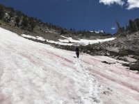
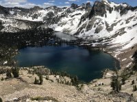
I just did the loop last weekend with my son. There is a little snow around 9000’.F7352DFD-022B-4F89-88D5-DAE3C2339F35.jpeg3BD2ED50-CF33-4744-BEEA-38B14C10BDE5.jpegF7352DFD-022B-4F89-88D5-DAE3C2339F35.jpeg Nothing sketchy at all. I’ll attach some pics of the pass between Toxaway and Twin lakes.
 

Don't like ads? Become a BCP Supporting Member and kiss them all goodbye. Click here for more info.

Back
Top