The Rookie Backpacker
Member
- Joined
- Jun 18, 2014
- Messages
- 7
Name: Unnamed Trail & Bushwhack
Area: Richland Creek WMA
Type: In and Out
Distance: 4.5 miles
Difficulty: Strenuous
During this short, but exciting, hike through the Richland Creek WMA, you will come across two beautiful waterfalls (Richland Falls & Twin Devils Falls) and a couple of creek crossings to eventually land you in the Sandstone Castles. Once used by outlaws to hide, these shallow caves provides hours of exploration and built in shelter from the elements. Climb a bit further to get a birds eye view of the WMA from the top of the castles.
From the lower loop at Richland Campgrounds (search GoogleMaps for driving directions), it's a short 200 yard walk to the first water crossing (Falling Water Creek). If it has rained recently, be prepared to get wet!
Across the creek you'll need to find the worn path to follow along Richland Creek (Along your right) for 2 miles until the next water crossing (Richland Creek).
After you cross Richland creek find the trail going up Long Devil's creek (Along your right) (<1 mile). Stay left at the trail fork to make your way to the top of Twin Devils Falls. This is the last call for water, so fill up!
Between the two creeks, follow Big Middle Ridge up for a strenuous .9 miles until you find the Castles.


Tents setup in one of the caves.

From atop the Castles

Sunrise view from atop the Castles
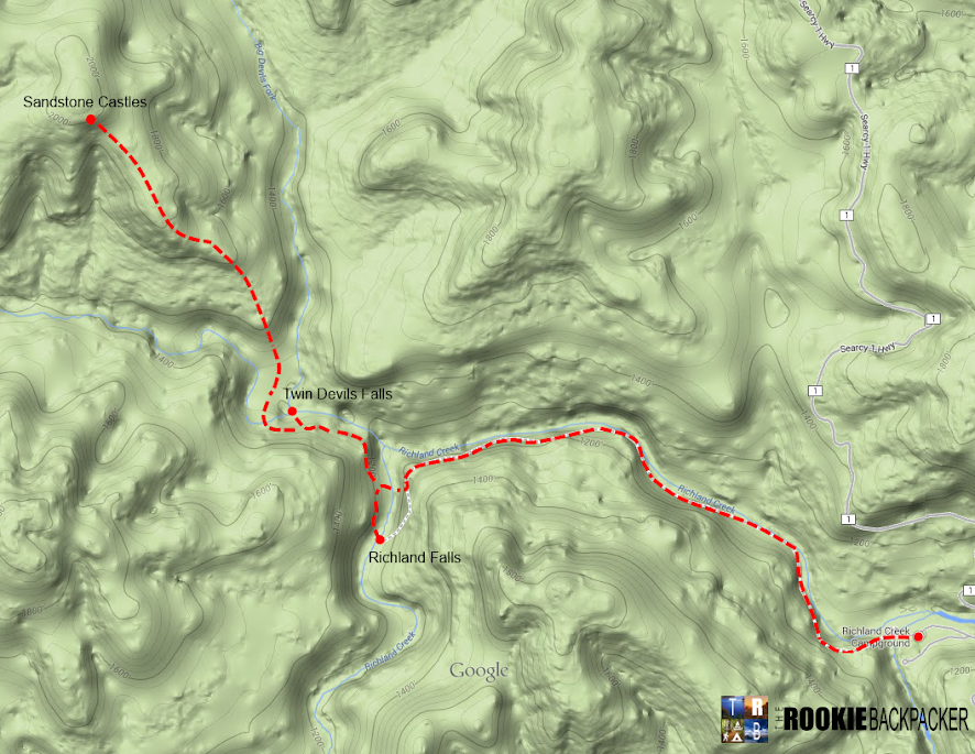
Topo of Richland Creek Wildlife Management Area w/Trail
Area: Richland Creek WMA
Type: In and Out
Distance: 4.5 miles
Difficulty: Strenuous
During this short, but exciting, hike through the Richland Creek WMA, you will come across two beautiful waterfalls (Richland Falls & Twin Devils Falls) and a couple of creek crossings to eventually land you in the Sandstone Castles. Once used by outlaws to hide, these shallow caves provides hours of exploration and built in shelter from the elements. Climb a bit further to get a birds eye view of the WMA from the top of the castles.
From the lower loop at Richland Campgrounds (search GoogleMaps for driving directions), it's a short 200 yard walk to the first water crossing (Falling Water Creek). If it has rained recently, be prepared to get wet!
Across the creek you'll need to find the worn path to follow along Richland Creek (Along your right) for 2 miles until the next water crossing (Richland Creek).
After you cross Richland creek find the trail going up Long Devil's creek (Along your right) (<1 mile). Stay left at the trail fork to make your way to the top of Twin Devils Falls. This is the last call for water, so fill up!
Between the two creeks, follow Big Middle Ridge up for a strenuous .9 miles until you find the Castles.
Tents setup in one of the caves.
From atop the Castles
Sunrise view from atop the Castles
Topo of Richland Creek Wildlife Management Area w/Trail
Last edited:
")