napatony13
Member
- Joined
- Feb 5, 2021
- Messages
- 196
Haven’t made a long trip like this in a few years, so squeezed a lot into a week. The main draw was a short backpacking trip into The Maze in Canyonlands (separate report to follow) but we made multiple stops on thr way there and back. Got treated to some fabulous fall color in the Eastern Sierra on my way down to Bishop to pick up my son.

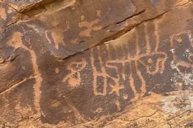
After spending the night there we caught Highway 6 and headed eastward towards Utah. Our first stop would be out past Tonopah in country about as bare and inhospitable as the Silver State gets. After leaving the highway we traveled about a dozen miles on good dirt roads and reached Petroglyph Butte. There was one fairly elaborate panel and several smaller ones. A lot of abstract stuff, some fertility symbols.

From there we continued on to Gooseberry Mesa in Utah where we camped for the night. We were back on the road before dawn the next morning as there was a lot to squeeze in on this day. We drove to Emery and then headed east into The Swell. Our first target was the Ascending Sheep panel. Since I didn’t think our truck camper would survive the road, we stopped and parked. Rather than walk the roundabout road route we headed off cross-country, hoping the GPS coordinates I had for the panel were accurate and our route wouldn’t be blocked. We made it there without incident. It’s a small panel but highly detailed. It took some real skill to paint all those tiny sheep.

After hoofing it back to the truck, our next two stops were just a short distance down the road. Nothing subtle about the giant snake petroglyph, very impressive!

A bit further was The Juggler...that one will test your imagination.

For the next stop we left the pavement just a bit further down the road. It should have been about a 5 mile drive to reach the site, but a washout about midway meant we were hoofing it again. Luckily it was mostly flat and there were some interesting rocks to see along the way. My directions to the rock art weren’t clear and we initially started up the wrong fork of the canyon. After a short time we separated, backtracked, and I eventually spotted our targets.


From there we continued east to Green River, then traveled gravel roads through some farm country towards the cliffs to the north. Once again we were stymied by a washed-out section and started walking. The busy main panel here was on the interior of a large boulder that had split in half. The narrow confines made seeing/photographing the entire thing at once impossible, but it contained a lot of very interesting components.


There were a few other boulders here to check out. The most interesting one showed a snake with human figures inside it and in front of it. Consuming them or expelling them? Either way it was fascinating to see.


Our final scheduled stop for the day was the well-known art work in Sego Canyon. We arrived in drizzling rain, but fortunately the road there is paved the entire way. The main attraction here is 3 large panels carved in different points in history by different cultures.


While it was interesting this site failed to “wow” me as much as expected. I’m not sure if it was the rain, the ease of getting there, the barriers that kept you from getting too close, or the graffiti damage nearby. Despite all the acclaim this site receives, I’ve enjoyed many others much more.


Then we headed towards Moab to secure our campsite. I had reserved a spot in Utah Velociraptor State Park. It was our only paid stay of the trip, but I wanted to be sure we were close to town as we had to check in for our river trip at 7am the next morning. We still had a couple hours of daylight left, and thought the passing storm clouds might make for some good photo opportunities out at Dead Horse, so we headed in that direction. But as we gained elevation we soon found ourselves socked in by fog/clouds...no good views tonight! So we flipped a U-turn and headed back.
We decided to make the easy roadside stop and see Intestine Man and the TV Sheep.


While there I saw on my GPS map that Snake in Mouth was just across the canyon a ways, so we crossed the road and started walking in that direction. We passed some petroglyphs fairly early on, then turned towards the spot my GPS indicated.


It was a bit of a struggle to get up to the high cliff band, and when I got there I found nothing...I guess my coordinates were wrong. I could make out a very faint trail along the base of the cliff, and figured there had to be a reason people found their way up here, so I walked the entire cliff face. Almost all the way to the opposite end I found my panel.

That night a fairly intense lightning storm passed over us...so much for getting a good night’s sleep before embarking on our Maze backpacking trip the next day (separate report to follow). A couple days later were back in Moab and ready to start on our way back home. We ate lunch in town, then I took my son to a bouldering gym so he could climb a bit and get a shower. I restocked our groceries and then formulated a plan for the night. I figured we could make it to Black Dragon Canyon before dark and find a place to camp there. I’d seen the pictographs there, but figured it would be a good one to show my son.
After an uneventful night we drove up to the panel the next morning. I am less impressed by the “dragon” than by the giant anthromorphs nearby. They’re just huge!


From there we would continue west on 70 and target the Head of Sinbad panel. While close to the highway, it’s a long detour on dirt roads to get there. Once again the weather got the better of us, with a road washout over a mile from our destination. It was deeper/worse than it looks here:

But after climbing out of Spanish Bottom with full packs a few days earlier, walking the road for a bit seemed pretty trivial. Interesting how the figure on the left matches the larger version back in Black Dragon, not too far away.


The final rock art stop would be the Rochester Panel. This was another one I’d seen but wanted my son to experience. So many fascinating components on this one, it really makes you stop and wonder what they were trying to convey. My previous stop here had been a brief one, driven off by a biting wind. Today it was pleasant and we got to spend our time with this fascinating canvas.


From there it was just a short hop to Orangeville and the Joe’s Valley area where my son wanted to spend a couple days climbing. It’s beautiful, productive farm country there with clear running streams and tons of boulders in the hills.


With no known (by me) rock art in this area, it made me question “why not?” There’s an abundance of it nearby in the seemingly much less hospitable Swell to the east, why not here? But I suppose that’s part of the allure of rock art...it presents us with many more questions than answers and really makes you think.
After spending the night there we caught Highway 6 and headed eastward towards Utah. Our first stop would be out past Tonopah in country about as bare and inhospitable as the Silver State gets. After leaving the highway we traveled about a dozen miles on good dirt roads and reached Petroglyph Butte. There was one fairly elaborate panel and several smaller ones. A lot of abstract stuff, some fertility symbols.
From there we continued on to Gooseberry Mesa in Utah where we camped for the night. We were back on the road before dawn the next morning as there was a lot to squeeze in on this day. We drove to Emery and then headed east into The Swell. Our first target was the Ascending Sheep panel. Since I didn’t think our truck camper would survive the road, we stopped and parked. Rather than walk the roundabout road route we headed off cross-country, hoping the GPS coordinates I had for the panel were accurate and our route wouldn’t be blocked. We made it there without incident. It’s a small panel but highly detailed. It took some real skill to paint all those tiny sheep.
After hoofing it back to the truck, our next two stops were just a short distance down the road. Nothing subtle about the giant snake petroglyph, very impressive!
A bit further was The Juggler...that one will test your imagination.
For the next stop we left the pavement just a bit further down the road. It should have been about a 5 mile drive to reach the site, but a washout about midway meant we were hoofing it again. Luckily it was mostly flat and there were some interesting rocks to see along the way. My directions to the rock art weren’t clear and we initially started up the wrong fork of the canyon. After a short time we separated, backtracked, and I eventually spotted our targets.
From there we continued east to Green River, then traveled gravel roads through some farm country towards the cliffs to the north. Once again we were stymied by a washed-out section and started walking. The busy main panel here was on the interior of a large boulder that had split in half. The narrow confines made seeing/photographing the entire thing at once impossible, but it contained a lot of very interesting components.
There were a few other boulders here to check out. The most interesting one showed a snake with human figures inside it and in front of it. Consuming them or expelling them? Either way it was fascinating to see.
Our final scheduled stop for the day was the well-known art work in Sego Canyon. We arrived in drizzling rain, but fortunately the road there is paved the entire way. The main attraction here is 3 large panels carved in different points in history by different cultures.
While it was interesting this site failed to “wow” me as much as expected. I’m not sure if it was the rain, the ease of getting there, the barriers that kept you from getting too close, or the graffiti damage nearby. Despite all the acclaim this site receives, I’ve enjoyed many others much more.
Then we headed towards Moab to secure our campsite. I had reserved a spot in Utah Velociraptor State Park. It was our only paid stay of the trip, but I wanted to be sure we were close to town as we had to check in for our river trip at 7am the next morning. We still had a couple hours of daylight left, and thought the passing storm clouds might make for some good photo opportunities out at Dead Horse, so we headed in that direction. But as we gained elevation we soon found ourselves socked in by fog/clouds...no good views tonight! So we flipped a U-turn and headed back.
We decided to make the easy roadside stop and see Intestine Man and the TV Sheep.
While there I saw on my GPS map that Snake in Mouth was just across the canyon a ways, so we crossed the road and started walking in that direction. We passed some petroglyphs fairly early on, then turned towards the spot my GPS indicated.
It was a bit of a struggle to get up to the high cliff band, and when I got there I found nothing...I guess my coordinates were wrong. I could make out a very faint trail along the base of the cliff, and figured there had to be a reason people found their way up here, so I walked the entire cliff face. Almost all the way to the opposite end I found my panel.
That night a fairly intense lightning storm passed over us...so much for getting a good night’s sleep before embarking on our Maze backpacking trip the next day (separate report to follow). A couple days later were back in Moab and ready to start on our way back home. We ate lunch in town, then I took my son to a bouldering gym so he could climb a bit and get a shower. I restocked our groceries and then formulated a plan for the night. I figured we could make it to Black Dragon Canyon before dark and find a place to camp there. I’d seen the pictographs there, but figured it would be a good one to show my son.
After an uneventful night we drove up to the panel the next morning. I am less impressed by the “dragon” than by the giant anthromorphs nearby. They’re just huge!
From there we would continue west on 70 and target the Head of Sinbad panel. While close to the highway, it’s a long detour on dirt roads to get there. Once again the weather got the better of us, with a road washout over a mile from our destination. It was deeper/worse than it looks here:
But after climbing out of Spanish Bottom with full packs a few days earlier, walking the road for a bit seemed pretty trivial. Interesting how the figure on the left matches the larger version back in Black Dragon, not too far away.
The final rock art stop would be the Rochester Panel. This was another one I’d seen but wanted my son to experience. So many fascinating components on this one, it really makes you stop and wonder what they were trying to convey. My previous stop here had been a brief one, driven off by a biting wind. Today it was pleasant and we got to spend our time with this fascinating canvas.
From there it was just a short hop to Orangeville and the Joe’s Valley area where my son wanted to spend a couple days climbing. It’s beautiful, productive farm country there with clear running streams and tons of boulders in the hills.
With no known (by me) rock art in this area, it made me question “why not?” There’s an abundance of it nearby in the seemingly much less hospitable Swell to the east, why not here? But I suppose that’s part of the allure of rock art...it presents us with many more questions than answers and really makes you think.