shredhiker
Member
- Joined
- Feb 14, 2023
- Messages
- 186
I'd been eyeballing this hike for a few years, but never could get around to making it happen. Starting a new job at the beginning of this year sort of threw my usual trap planning out the window. When I finally had an idea of my travel window for the summer, there was an open permit for Yosemite starting from Glacier Point. I ran the idea by my buddies in regards to our annual Sierra trip, and they pretty much trusted me to plan something decent. I opted for the 50 mile loop starting & ending from GP. Ideally, I'd liked to have hiked out to Yosemite Valley, but with the time window we had, transportation between trailheads was too much of a grey area.
It was a pretty easy travel day flying into Fresno, picking up our usual supplies, then making our way toward Yosemite. When we arrived at the Wawona wilderness office, the power was out. The ranger was happy to hand write our permit, ask us a few basic questions about our understanding of the regulations, and send us on our way. We spent the first night at Bridalveil Creek campground, which was fairly easy to get a site, and would make a short drive to our starting point the following morning. The campground was pretty peaceful by Yosemite standards, we were able to enjoy the sunset view from Glacier Point nearby.

Day 1 7/24 :
The first day was a pretty easy downhill hike, starting with big expansive views across the valley, looking toward Clouds Rest & Half Dome. A few miles in, we escaped the crowds of day hikers and enjoy the nice wooded trail along Illilouette Creek. We found a good camp around 4 miles in, near the Buena Vista trail junction. We expected it would be quite a while before the trail crossed a good water source & decided to end the day there.

Day 2:
We'd hoped the 2nd day would have us making it over Red Peak Pass to camp at one of the unnamed lakes on the other side. That would have meant a very ambitious 15 mile day with nearly a 5,000 ft climb. Early on, we decided to just push on as far as it made sense, knowing we'd probably stop short of that & have a longer day later in the trip. We made decent time for most of the day, stopping at Lower Merced Pass Lake for lunch. As we got later into the afternoon, grey skies began to form overhead, which had us hesitant to attempt the pass that day.
We reached Lower Ottaway Lake around 3:00, and with scattered rain clouds and fog all around, decided to camp there. There was another group stopping at the lake who decided to continue on over the pass. They lucked out with no thunderstorms that day, but we were happy to enjoy the views around the lake for the evening. We ended up hiking nearly 12 miles and climbing 3,400 ft.


Day 3:
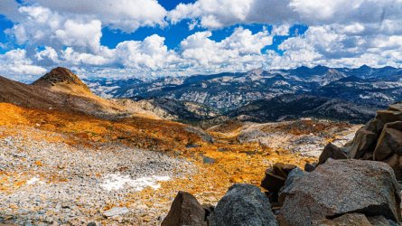
We got a fairly early start, and made pretty quick work getting up to Red Peak Pass. Stopping to enjoy the views as often as needed, there was a large group of 10 when we arrived up there. After they moved on, we hung out a few minutes longer to take just a few more photos before starting the descent. It's such a beautiful and unique landscape, it's hard to keep moving. We were glad we didn't do it the previous afternoon with all the clouds & fog.
Our plan was to try to make camp somewhere in the relatively flat valley along Triple Peak Fork. Unfortunately, this was the one area of the trail where the bugs were just absolutely horrendous. Other than a short break to douse ourselves in bug spray, we mostly speed-hiked through that section. We ended up finding a nice spot near the Merced Peak Fork, with a great view looking over Washburn Lake. This was another 12 mile day, mostly downhill after the 1,400 ft climb to the pass first thing.


Day 4:
The day started with a pretty steep descent down to Washburn Lake, but was pleasantly flat for most of the day afterward. We ran into a few other people hanging around the Merced Lake High Sierra Camp. I was excited to arrive at Merced Lake on a beautiful day with clear skies. The only other time I'd been there was in 2020, and the area was so thick with wildfire smoke, I couldn't even see across the lake. I'd attempted a few early season hikes since then, but never quite made it that far. We made camp about a mile past Merced Lake, at a campsite hidden up in the smooth granite, that I'd discovered my first time out there. It was a scenic and easy 8 mile day.
Day 5:
This had to be the most boring day of the trip, the all familiar hike to Little Yosemite Valley. While the day started out with gorgeous views of Clark Canyon & Echo Valley, just a few miles in we reached Bunnell Cascade & dropped down into the old fire burn. Rattlesnakes are common along this stretch of trail, which is heavily overgrown and always makes me nervous to hike through. We didn't encounter any that day though, and made it to camp well in time to snag a couple of good shaded sites. The backpackers campground was crowded & chaotic as one would expect, quite the departure from the peacefulness we'd experienced up to then. It was nice having pit toilets though, and the sandy beach section of the Merced nearby was still enjoyable.
There are always a handful of first time backpackers around. A few got scolded by the ranger on hand, even citations for a few of them. I suppose it was mildly entertaining if nothing else. One couple left food in their tent, walked away for an hour & squirrels had chewed right through. Some other oblivious campers set their tents up right outside the tent boundary, which was clearly marked by signs. When a black bear wandered through camp, we watched a dozen people chase it down to take photos leaving their open food containers lying all over the place. I suppose we all started somewhere, I should be grateful my blunders were on a smaller scale with no one watching. This was another easy day, covering 8.5 miles.
Day 6:
The dreaded hike out, climbing back up to Glacier Point. This was one of only two days that we intentionally got up early, with dreams of cold beer & hot pizza from Curry Village, not to mention showers in our future. With our packs nearly 10 lbs lighter than we hiked in with, we made it up to Nevada Fall easily enough, then began the switchbacks up the Panorama Trail shortly after. I took plenty of breaks during the steep climb, but there was no shortage of scenery to enjoy.
We made it back to the trailhead before noon. After the nightmare of finding parking in the valley, down by the Happy Isles trailhead, we walked back to Curry for the long awaited pizza & beer lunch. After a couple of hours relaxing in the shade, we grabbed a few beers to go & made the drive up to White Wolf campground. We'd hoped to spend some time driving up Tioga Road, but were so tired we were perfectly content just lazily hanging around camp as we packed our luggage for the flight home.
It was a pretty easy travel day flying into Fresno, picking up our usual supplies, then making our way toward Yosemite. When we arrived at the Wawona wilderness office, the power was out. The ranger was happy to hand write our permit, ask us a few basic questions about our understanding of the regulations, and send us on our way. We spent the first night at Bridalveil Creek campground, which was fairly easy to get a site, and would make a short drive to our starting point the following morning. The campground was pretty peaceful by Yosemite standards, we were able to enjoy the sunset view from Glacier Point nearby.
Day 1 7/24 :
The first day was a pretty easy downhill hike, starting with big expansive views across the valley, looking toward Clouds Rest & Half Dome. A few miles in, we escaped the crowds of day hikers and enjoy the nice wooded trail along Illilouette Creek. We found a good camp around 4 miles in, near the Buena Vista trail junction. We expected it would be quite a while before the trail crossed a good water source & decided to end the day there.
Day 2:
We'd hoped the 2nd day would have us making it over Red Peak Pass to camp at one of the unnamed lakes on the other side. That would have meant a very ambitious 15 mile day with nearly a 5,000 ft climb. Early on, we decided to just push on as far as it made sense, knowing we'd probably stop short of that & have a longer day later in the trip. We made decent time for most of the day, stopping at Lower Merced Pass Lake for lunch. As we got later into the afternoon, grey skies began to form overhead, which had us hesitant to attempt the pass that day.
We reached Lower Ottaway Lake around 3:00, and with scattered rain clouds and fog all around, decided to camp there. There was another group stopping at the lake who decided to continue on over the pass. They lucked out with no thunderstorms that day, but we were happy to enjoy the views around the lake for the evening. We ended up hiking nearly 12 miles and climbing 3,400 ft.
Day 3:
We got a fairly early start, and made pretty quick work getting up to Red Peak Pass. Stopping to enjoy the views as often as needed, there was a large group of 10 when we arrived up there. After they moved on, we hung out a few minutes longer to take just a few more photos before starting the descent. It's such a beautiful and unique landscape, it's hard to keep moving. We were glad we didn't do it the previous afternoon with all the clouds & fog.
Our plan was to try to make camp somewhere in the relatively flat valley along Triple Peak Fork. Unfortunately, this was the one area of the trail where the bugs were just absolutely horrendous. Other than a short break to douse ourselves in bug spray, we mostly speed-hiked through that section. We ended up finding a nice spot near the Merced Peak Fork, with a great view looking over Washburn Lake. This was another 12 mile day, mostly downhill after the 1,400 ft climb to the pass first thing.
Day 4:
The day started with a pretty steep descent down to Washburn Lake, but was pleasantly flat for most of the day afterward. We ran into a few other people hanging around the Merced Lake High Sierra Camp. I was excited to arrive at Merced Lake on a beautiful day with clear skies. The only other time I'd been there was in 2020, and the area was so thick with wildfire smoke, I couldn't even see across the lake. I'd attempted a few early season hikes since then, but never quite made it that far. We made camp about a mile past Merced Lake, at a campsite hidden up in the smooth granite, that I'd discovered my first time out there. It was a scenic and easy 8 mile day.
Day 5:
This had to be the most boring day of the trip, the all familiar hike to Little Yosemite Valley. While the day started out with gorgeous views of Clark Canyon & Echo Valley, just a few miles in we reached Bunnell Cascade & dropped down into the old fire burn. Rattlesnakes are common along this stretch of trail, which is heavily overgrown and always makes me nervous to hike through. We didn't encounter any that day though, and made it to camp well in time to snag a couple of good shaded sites. The backpackers campground was crowded & chaotic as one would expect, quite the departure from the peacefulness we'd experienced up to then. It was nice having pit toilets though, and the sandy beach section of the Merced nearby was still enjoyable.
There are always a handful of first time backpackers around. A few got scolded by the ranger on hand, even citations for a few of them. I suppose it was mildly entertaining if nothing else. One couple left food in their tent, walked away for an hour & squirrels had chewed right through. Some other oblivious campers set their tents up right outside the tent boundary, which was clearly marked by signs. When a black bear wandered through camp, we watched a dozen people chase it down to take photos leaving their open food containers lying all over the place. I suppose we all started somewhere, I should be grateful my blunders were on a smaller scale with no one watching. This was another easy day, covering 8.5 miles.
Day 6:
The dreaded hike out, climbing back up to Glacier Point. This was one of only two days that we intentionally got up early, with dreams of cold beer & hot pizza from Curry Village, not to mention showers in our future. With our packs nearly 10 lbs lighter than we hiked in with, we made it up to Nevada Fall easily enough, then began the switchbacks up the Panorama Trail shortly after. I took plenty of breaks during the steep climb, but there was no shortage of scenery to enjoy.
We made it back to the trailhead before noon. After the nightmare of finding parking in the valley, down by the Happy Isles trailhead, we walked back to Curry for the long awaited pizza & beer lunch. After a couple of hours relaxing in the shade, we grabbed a few beers to go & made the drive up to White Wolf campground. We'd hoped to spend some time driving up Tioga Road, but were so tired we were perfectly content just lazily hanging around camp as we packed our luggage for the flight home.


")