- Joined
- Jul 23, 2013
- Messages
- 1,665
I was looking at taking a little trip into Naturalist Basin in a couple of weeks and was originally just going to stay one night. Now I'm thinking I'd like to go up the ridge south of Hayden and drop down into Middle Basin first for a night, then head cross country south east to the ridge that runs east of Mount Agassiz to get up and over into Naturalist Basin for a night. I'm familiar with the first ridge, though I haven't actually ascended or descended it from the MLH side. I've only done it as a day hike when spending some time up around Ryder Lake. I have a few questions...
1. Would that second ridge crossing, between Middle Basin and Naturalist Basin, be anything too spicy? Topographically, it looks no worse than the first ridge between MLH and Middle Basin. In fact, it looks like it'd be quite a bit easier. From the looks of things, the steepest slope would be the one descending down into Middle Basin, which is the one I'm familiar with. Can anyone confirm?
2. Could I expect the snow to be cleared off those ridges in 2 weeks, or would it be better to hold off until July? I'd like to experience the basins when they're nice and green, blooming with flowers, flowing with waterfalls, while still catching some patches of snow on the higher peaks surrounding the area.
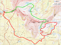
Here's the route I'm considering. Red was my original plan. Green is my latter addition in an effort to include Middle Basin in the trip.

EDIT: I'm also open to doing it the opposite way (Naturalist first, then Middle), which might actually be a better way to do it if I'm right about the steepest grade occurring on the slope heading westward and upward from Middle Basin.
1. Would that second ridge crossing, between Middle Basin and Naturalist Basin, be anything too spicy? Topographically, it looks no worse than the first ridge between MLH and Middle Basin. In fact, it looks like it'd be quite a bit easier. From the looks of things, the steepest slope would be the one descending down into Middle Basin, which is the one I'm familiar with. Can anyone confirm?
2. Could I expect the snow to be cleared off those ridges in 2 weeks, or would it be better to hold off until July? I'd like to experience the basins when they're nice and green, blooming with flowers, flowing with waterfalls, while still catching some patches of snow on the higher peaks surrounding the area.
Here's the route I'm considering. Red was my original plan. Green is my latter addition in an effort to include Middle Basin in the trip.

EDIT: I'm also open to doing it the opposite way (Naturalist first, then Middle), which might actually be a better way to do it if I'm right about the steepest grade occurring on the slope heading westward and upward from Middle Basin.
Last edited:


