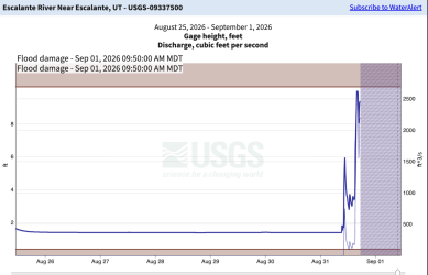
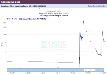
Possible Escalante River gage damage from yesterday's flash flooding

Oof. I got the alert this morning on the gauge height and was flabbergasted but I didn't see that it was offline at that point. Almost certainly damaged or wiped out. A month ago I was starting to get concerned on how water conditions might be for an upcoming trip to the area in October. Fears allayed.
 
We had a series of heavy storm cells in southern UT yesterday. It's unclear whether the Escalante River gage survived the flash flood.

The nearby Pine Creek one looks to be online.

Yeah, that was a pretty impressive line of storms. I wouldn’t be surprised if the Escalante gauge got buried, knocked around, or was just temporarily reporting bad data after that kind of surge. Those canyon drainages can make a mess of anything mounted low.

Good call checking Pine Creek as a nearby reference, though it can behave pretty differently depending on where the cells parked. If anyone was planning an Escalante trip in the next day or two, I’d treat the gauge with caution until there’s some confirmation it’s reading normally again.
 
I just spoke to a friend who guides USGS river trips on the CO River. He said that a USGS gage ops person said that they sometimes see temporary dams created from flash flood debris, which can spike the gage readings. The Escalante River gage sits is a relatively open flood plain area, so that must have a been a major debris flow.
 
Back
Top