OpenStreetMap survey on risk management for trailless routes

fossana

Member
Joined
Jan 11, 2018
Messages
954
[OK'd by Nick]

For the past few months I have been volunteering with OpenStreetMap (OSM) US' Trails Stewardship Initiative, which has been focused on southern UT. For those that aren't familiar with OSM, it's a nonprofit that hosts a crowdsourced, worldwide mapping platform. OSM's data feeds many trail apps, including CalTopo, Gaia, OnX, and AllTrails. The Trails Stewardship Initiative is a partnership between OSM, land management agencies, trail app developers, and volunteers to clarify official trails and trail access, and to improve trail routing and attributes with the aim of:
  • Reducing ecological and archeological impact
  • Reducing SAR incidents
One of the things were are currently evaluating is how best to visualize and what standard attributes to collect for trailless routes. Trailless routes in the Trails Stewardship project context are official named routes that lack an established, managed path. The safest path along these routes may change seasonally. This includes routes like the wading portion of the Zion NP Narrows, routes that cross seasonal snowfields, and routes that follow intermittent streams.

To better inform our efforts, I put together a short (5-10 min) survey on risk management for trailless routes. If you are interested in participating, here's the link.
Please have your responses in by Sunday, 28 July 2024. Thanks in advance for participating.

If you would like to learn more about the Trails Stewardship Initiative, there's an online information session on August 22nd.
 
Fossana,

Thanks for working on this. There will always be a tension between those who want to explore and figure out routes for themselves and those who want to be handed a detailed GPS track. The real downside of publishing the the track is obvious: too many people, some of who are not skilled enough, will follow the line in their phone and after a while, that line will no longer be trailless. We did Roper's Sierra High Route back in '97 when there was only his written description in his book. You knew you had to cross that untrailed pass, but no more than that and thus had to figure out a route that worked for you. That was one of the reasons we found the SHR to be such a fabulous route. Now, if I am not mistaken, you can download a detailed GPS track for the route and follow the exact footsteps of the previous hikers and know exactly which notch on that distant ridge you have cross. A lot is lost when that happens, both as damage to the landscape and adventure to the walker.

We are also personally guilty of publishing tracks for our routes and I am quite conflicted about our doing so. We want to share, but perhaps we should be doing it in a less detailed fashion.

James and Amy
 
Did the survey, and like others I have major concerns about oversharing of trailless or lightly trafficked routes. Here in Alberta, we have seen a few formerly quiet untracked places turned into overcrowded s...shows after being exposed on All Fails and by a couple of our local "influencers".
 
I think "official" is kind of an (unintentional) weasel word here. Most would regard the Hayduke as unofficial, yet there it is on OSM. And then you have the conundrum that Capitol Reef has a special section (and, if you actually ask them, special procedures) on their backcountry page for Hayduke hikers. So is it an official route, or no? "Official" turns out to be more of a spectrum than a category.

To eliminate the ambiguity, and to push things in the direction of greater safety and less ecological impact, my personal view is that anything shown on an official park/land management map should be on OSM, whereas everything else should not.
Just to clarify, we are taking the latter approach for "official", namely anything shown on an official park/land management map should be on OSM, for the Trails Stewardship Initiative.
 
Hayduke on OSM seems to be in very poor taste, and might even be borderline dangerous. Earlier this year I was watching a YT video by a guy who was about to do the Hayduke with like an 8 lb base weight. Like, bro, that seems a little nutty.
I mean, my base was probably not far off from 8 lb, but then again, I don't claim not to be nutty :)
 
lol..... my base is around 8 to 10 lb as well........ what are you counting as "base" makes a difference
 
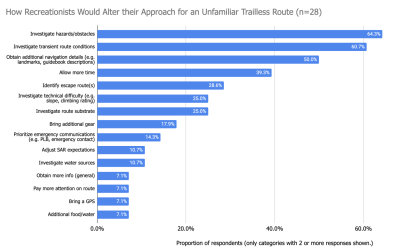
Thanks everyone for participating in the survey. The full analysis is attached. Below is the breakdown of how respondents would approach an unfamiliar trailless route differently from an established trail. I did not find a significant difference in risk management approach between people with different levels of trailless route experience, but that could be due to small numbers of less experienced participants.

2/3 of those who provided optional feedback recommended not showing trailless routes on maps. I've shared the results with the OSM Trails Working Group.

Screenshot 2024-07-29 at 5.26.28 PM.png
 

Attachments

  • Risk Management on Trailless Routes.pdf
    270.6 KB · Views: 2
Still think something showing trailless routes is not needed. Take for example the "windriver high route" ........ There are as many routes to be called this as there are people looking at a map.
 
Still think something showing trailless routes is not needed. Take for example the "windriver high route" ........ There are as many routes to be called this as there are people looking at a map.
Completely agree that unofficial routes like WRHR, SHR, Hayduke, Steve Allen routes, etc. should not be on the maps, but there are instances of official NPS/USFS/BLM routes that are trailless, like the Zion Narrows, Death Hollow, etc. that aren't going away, and could be better described to set realistic user expectations and reduce backcountry impact.
 
A bit different.. . You're stuck in a canyon pretty much one way. Probably a liability for suggesting any route...
 
Back
Top