bicycle
"I'm two tired"
- Joined
- Apr 14, 2025
- Messages
- 8
(inspired by https://www.citrusmilo.com/zionguide/barracks.php)
Zion starts to get extremely crowded in the spring, but after hiking to the "Subway" last week, I craved more of the magical crystal clear water, slot canyons, biodiversity, and color. I was looking for something a lot quieter than the main canyon and settled on hiking part of "The Barracks" which is a relatively narrow section of Parunuweap Canyon carved by the east fork of the Virgin River. Parunuweap is nontechnical hiking all the way from Mt. Carmel Junction to Labyrinth Falls in Zion itself, where you can't proceed.
Access to Parunuweap is prohibited within Zion NP itself to preserve the lower section (near old Shunesburg) as a wilderness study area, so the main ways to access this part of the canyon are A. hiking about 20 miles westward from Mt. Carmel Junction via the mouth of the canyon, or B. hiking south to the canyon from UT-9 (the road between Mt. Carmel Junction and the Mt. Carmel Tunnel into Zion). UT-9 basically parallels Parunuweap, and there are a number of approaches.
One option is within the park boundary: park your vehicle at one of the designated pullouts near Checkerboard Mesa and hike south to the canyon, then back up the same way. If you have all day, this is the most direct route, but it's steep.
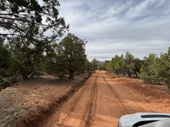
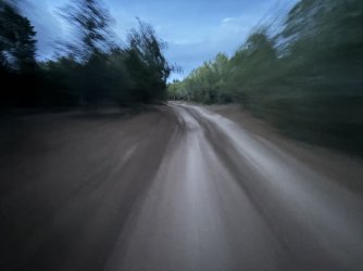
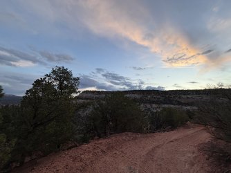
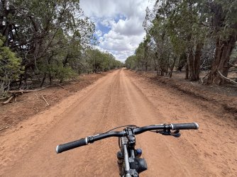
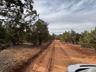
The other option is via BLM land just outside the park. From UT-9, a hardpack dirt road called Poverty Road crosses a cattle guard and leads into a large pinyon-juniper mesa with many dispersed camping sites. It looks like this area is used by hunters during hunting season, and I saw several wild turkeys and deer.
Click here to view on CalTopo
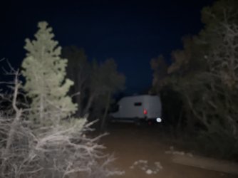
I parked the camper van at one of these sites for a few days while I planned a route.

Poverty Road actually goes all the way down to the river, but vehicles without 4x4 low gearing will not have a good time climbing back out of the steep descent as the road crosses over a wash, just 1-2 miles down the road.

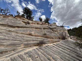
In addition, the descent of the White Cliffs themselves is steep, narrow, and exposed, and I wouldn't recommend anything larger than a Jeep attempt the final descent to the river itself. A dirt bike or SxS would be fine.


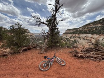
I brought my mountain bike and it was only useful up on the mesa: the deep sand at the bottom of the White Cliffs was pure hike-a-bike, and pushing the bike through sand for miles was not very fun. I recommend stashing your bike before descending - even though it looks fun to ride down, it quickly turns to sand.

Up close and personal with the White Cliffs.

Drudge through the sand a few more miles to the river.

Finally! The fun begins.

The water felt good. No neoprene socks required this time of year.
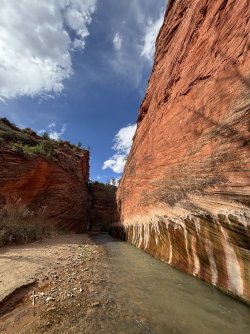
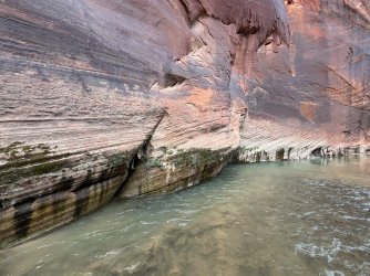
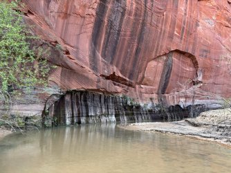
Colorful rock walls rise straight out of the river as you walk downstream.


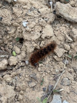
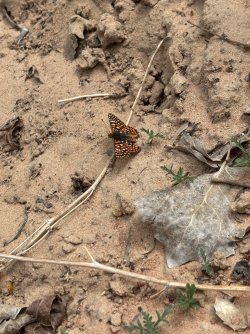
Wildlife abounds in the canyon.


After a mile or two, the canyon gets narrower.


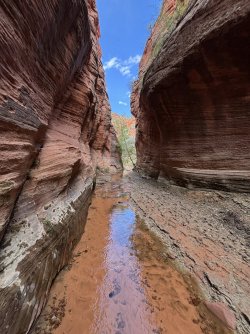
Starting up Poverty Wash, I felt anything but poor.


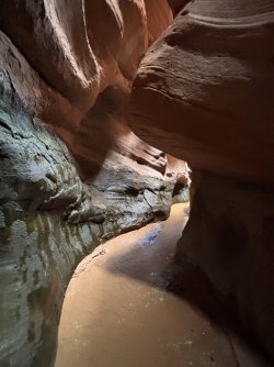
Poverty Wash gets narrower as you go on.


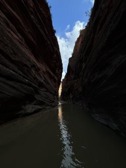
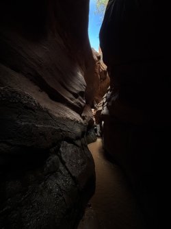
A short but beautiful slot section feels otherworldly as the sandstone walls play tricks with the light.


At the end of the slot is a grotto room that's impassable without climbing.

Spend some time in there before heading back out of Poverty Wash.


Poverty Wash was as far as I planned to go, so I turned back around.
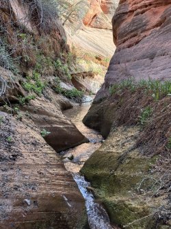
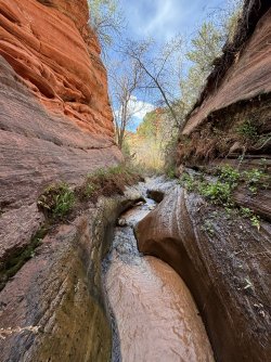
Another interesting side canyon called French Canyon beckons on the way back.
French Canyon ended up being incredibly lush and green.

It just kept getting greener!


Eventually French Canyon will dead end at a rockfall where the water goes underground. Turn back around and get back to the river.

Walking upstream is more taxing than walking downstream, so allow yourself some extra time getting back. No reason to rush down here, anyway, enjoy the magic for as long as you can.

There are several petroglyph sites along this hike. This modern mud art helps point out the location of a panel to the right.


I really enjoyed the colors down here.

Spring flowers starting to bloom.
Getting back up was a real drag, especially dragging the bike along with me.

A little sketchy to be in cougar country at this time of day, but I made it back. The bike really helped on this section of road up on the mesa.

All in all, about 25 miles. This was exactly what I hoped for, and I'm planning to do the longer route from Mt. Carmel Junction to Checkerboard Mesa as a shuttled overnight next time I'm out here with a trail buddy. This is my first TR and first time using caltopo so I'm open to any pro-tips you might have. Thanks for reading!
Zion starts to get extremely crowded in the spring, but after hiking to the "Subway" last week, I craved more of the magical crystal clear water, slot canyons, biodiversity, and color. I was looking for something a lot quieter than the main canyon and settled on hiking part of "The Barracks" which is a relatively narrow section of Parunuweap Canyon carved by the east fork of the Virgin River. Parunuweap is nontechnical hiking all the way from Mt. Carmel Junction to Labyrinth Falls in Zion itself, where you can't proceed.
Access to Parunuweap is prohibited within Zion NP itself to preserve the lower section (near old Shunesburg) as a wilderness study area, so the main ways to access this part of the canyon are A. hiking about 20 miles westward from Mt. Carmel Junction via the mouth of the canyon, or B. hiking south to the canyon from UT-9 (the road between Mt. Carmel Junction and the Mt. Carmel Tunnel into Zion). UT-9 basically parallels Parunuweap, and there are a number of approaches.
One option is within the park boundary: park your vehicle at one of the designated pullouts near Checkerboard Mesa and hike south to the canyon, then back up the same way. If you have all day, this is the most direct route, but it's steep.
The other option is via BLM land just outside the park. From UT-9, a hardpack dirt road called Poverty Road crosses a cattle guard and leads into a large pinyon-juniper mesa with many dispersed camping sites. It looks like this area is used by hunters during hunting season, and I saw several wild turkeys and deer.
Click here to view on CalTopo
I parked the camper van at one of these sites for a few days while I planned a route.
Poverty Road actually goes all the way down to the river, but vehicles without 4x4 low gearing will not have a good time climbing back out of the steep descent as the road crosses over a wash, just 1-2 miles down the road.
In addition, the descent of the White Cliffs themselves is steep, narrow, and exposed, and I wouldn't recommend anything larger than a Jeep attempt the final descent to the river itself. A dirt bike or SxS would be fine.
I brought my mountain bike and it was only useful up on the mesa: the deep sand at the bottom of the White Cliffs was pure hike-a-bike, and pushing the bike through sand for miles was not very fun. I recommend stashing your bike before descending - even though it looks fun to ride down, it quickly turns to sand.
Up close and personal with the White Cliffs.
Drudge through the sand a few more miles to the river.
Finally! The fun begins.
The water felt good. No neoprene socks required this time of year.
Colorful rock walls rise straight out of the river as you walk downstream.
Wildlife abounds in the canyon.
After a mile or two, the canyon gets narrower.
Starting up Poverty Wash, I felt anything but poor.
Poverty Wash gets narrower as you go on.
A short but beautiful slot section feels otherworldly as the sandstone walls play tricks with the light.
At the end of the slot is a grotto room that's impassable without climbing.
Spend some time in there before heading back out of Poverty Wash.
Poverty Wash was as far as I planned to go, so I turned back around.
Another interesting side canyon called French Canyon beckons on the way back.
French Canyon ended up being incredibly lush and green.
It just kept getting greener!
Eventually French Canyon will dead end at a rockfall where the water goes underground. Turn back around and get back to the river.
Walking upstream is more taxing than walking downstream, so allow yourself some extra time getting back. No reason to rush down here, anyway, enjoy the magic for as long as you can.
There are several petroglyph sites along this hike. This modern mud art helps point out the location of a panel to the right.
I really enjoyed the colors down here.
Spring flowers starting to bloom.
Getting back up was a real drag, especially dragging the bike along with me.
A little sketchy to be in cougar country at this time of day, but I made it back. The bike really helped on this section of road up on the mesa.
All in all, about 25 miles. This was exactly what I hoped for, and I'm planning to do the longer route from Mt. Carmel Junction to Checkerboard Mesa as a shuttled overnight next time I'm out here with a trail buddy. This is my first TR and first time using caltopo so I'm open to any pro-tips you might have. Thanks for reading!
Attachments
-
 IMG_5021.jpeg501 KB · Views: 1
 -
 IMG_5010.jpeg155.1 KB · Views: 1
 -
 IMG_5008.jpeg219.8 KB · Views: 1
 -
 IMG_5007.jpeg282.3 KB · Views: 1
 -
 IMG_4984.jpeg576.9 KB · Views: 1
 -
 IMG_4944.jpeg511 KB · Views: 1
 -
 IMG_4936.jpeg534.4 KB · Views: 1
 -
 IMG_4920.jpeg207.8 KB · Views: 1
 -
 IMG_4916.jpeg694.2 KB · Views: 1
 -
 IMG_4876.jpeg190.5 KB · Views: 1
 -
 IMG_4875.jpeg281.7 KB · Views: 1
 -
 IMG_4867.jpeg644.6 KB · Views: 1
 -
 IMG_4834.jpeg518.3 KB · Views: 1
 -
 IMG_4832.jpeg525.5 KB · Views: 1
 -
 IMG_4744.jpeg528.1 KB · Views: 1
 -
 IMG_4748.jpeg532.1 KB · Views: 1
 -
 IMG_4764.jpeg549.6 KB · Views: 1
 -
 IMG_4764.jpeg549.6 KB · Views: 1
 -
 IMG_4744.jpeg528.1 KB · Views: 1
 -
 IMG_4748.jpeg532.1 KB · Views: 1
 -
 IMG_4744.jpeg736.3 KB · Views: 1
 -
 IMG_4748.jpeg736.4 KB · Views: 1
 -
 IMG_4823.jpeg772.4 KB · Views: 1
 -
 IMG_5010.jpeg259.1 KB · Views: 2
 -
 IMG_5021.jpeg697.2 KB · Views: 1
Last edited:
")