PLAN B
We escaped the madness of Jackson by driving west over Teton Pass and through Victor and Driggs, Idaho. I had originally hoped to do a short hike along the way, but time, energy, and motivation were all in short supply. Instead, we headed for our campground. From Driggs we headed back east towards the Grand Targhee Resort and Teton Canyon. The resort, Teton Canyon, and most of the rest of the west side of the Tetons are in Wyoming, even though the adjacent towns are in Idaho. We continued on to Reunion Flats Campground, where we had campsite 1 reserved for two nights. Campsite 1 is close to the group site. Luckily it was unoccupied, and we had the area all to ourselves.
We had brought chicken to grill, but the campsite had one of those awful firepits that is 2 feet deep with a grill that isn’t adjustable. Cooking on it would’ve taken several hours or required about 30 pounds of charcoal. I poked around the group campsite, and found some large pieces of firewood. Jackson helped me roll them back to our site, and I used one of them as a platform for the charcoal. That put the coals within the same zip code as the chicken. Hey honey, we don’t have to wait until tomorrow morning to eat dinner!

The charcoal goes on top of the log
The plan for the rest of the trip was a little up in the air. We were going to do another backpacking trip, but there were two options. Plan A was an ambitious backpacking trip starting the next day (Thursday). The destination would be a base camp with several nights in Alaska Basin, at the head of Teton Canyon. If we decided to attempt it, I would get up early and walk 2 miles down the road to the Teton Canyon Campground and trailhead. I’d continue up the trail 8 miles to Alaska Basin with most of our camping gear. I’d find a suitable campsite, set up camp, and hike back. The next morning we would all hike in together, with me carrying Jackson most of the way. We would spend several days doing dayhikes, some of them quite ambitious, before we headed back out.
The other option was a little shorter and easier. That plan called for dayhikes on Thursday and Friday, followed by primitive car camping near the Green Mountain Trailhead. On Saturday morning I would hike in to the Green Lakes (5ish miles), set up camp, and return. That afternoon we would all hike in together. We would spend a few days doing dayhikes from there before heading back.
Ultimately we decided to go with the easier option. I was a little disappointed, but I also wanted to enjoy it. Plan A might have killed us. As it turns out, Plan B was enjoyable, and maybe even better?
THE AMITYVILLE HORROR
The minor change in plans meant that we had a couple of free days. Fortunately, there are a lot of great dayhikes on the west side of the Tetons. On Thursday, we decided to hike the Coal Creek Trail from the Teton Pass highway to Mesquite Divide. After breakfast we drove west from the campground to Driggs, Idaho. Then we headed back over Teton Pass into Wyoming. The Coal Creek Trailhead is a couple of miles beyond the pass. The parking lot was nearly full when we arrived, late that morning.

View of the moon from the trailhead
The Coal Creek Trail is extremely popular, for good reason. It is easy to access, and the wildflowers were great. There were also some nice aspen groves, and the view of the Grand Teton from Mesquite Divide is lovely. On the other hand, the flies were an abomination. I have never experienced flies like that. I’ve endured swarms of mosquitoes countless times, but these flies nearly drove me to madness. Most of them weren’t biting varieties – they were just extremely annoying – constantly in your face or landing on your arms or legs.

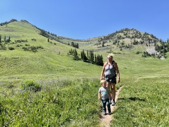
Christy heading up the trail

Christy hiking through an aspen grove

View south

Christy nearing Mesquite Divide

Christy nearing Mesquite Divide

Variable Linanthus

Grand Teton from Mesquite Divide

Hiking back

Red, white, and blue
It was a pretty lousy day for me. A couple of rest days should have rejuvenated me, but instead, carrying Jackson was beating me up more than normal. I struggled, and Jackson had a tough, fussy day, too. I’m sure the flies were bugging him just as much as they were me.
On the way back to the campground, we stopped in Victor for ice cream. There was a bluegrass band playing a free show in the park across the street, which was delightful. My huckleberry ice cream was delightful, too. We got Jackson strawberry ice cream, because he loves strawberries. Unfortunately, he doesn’t love ice cream – in fact, he refuses to touch it. Ultimately Christy got double ice cream that day.
We returned to our campsite, grilled another dinner, and enjoyed a campfire. Our hike that day had been a little disappointing, so I was determined to make up for it on Friday. Fortunately, I had an idea for a hike that would do that, and more.
GIMME SHELTER
“Ooh, a storm is threatening
My very life today
If I don't get some shelter
Ooh yeah, I'm gonna fade away
War, children, it's just a shot away
It's just a shot away
War, children, it's just a shot away
It's just a shot away”
From “Gimme Shelter” by the Rolling Stones, written by Mick Jagger and Keith Richards
We got up early on Friday, had breakfast, and broke camp. My plan for the day was a hike to the Darby Wind Cave. Christy decided to take the day off, but she needed a real break. I agreed to take Jackson, even though it meant that I would be carrying him up a mountain for the second day in a row.
After a long, bumpy drive from Victor, Christy dropped us off at a large, crowded parking area at the trailhead. Apparently the hike is popular! After Christy left, I realized that the bear spray was still in the car. Oops. I decided that we would be ok, considering the incredible number of cars at the trailhead. It looked like we would have a lot of company on our hike.
After a few minutes we entered a meadow and passed the location of the junction of the trail that leads towards Mount Meek. However, there was no hint of the trail. I’m guessing that it is lightly used and indistinct in the meadow.

The trail to Mount Meek should be right here
Just after that we reached a bridge over Darby Creek. We stopped there so that Jackson could play and throw rocks in the stream. Shortly after we left the trail began to climb. It wasn’t long before I was carrying Jackson on my back, again. Shortly after that he fell asleep, and he napped most of the way to the cave

Darby Creek
The climb was a lot more grueling than I expected. Of course, by that point, everything was more grueling than I expected if I was carrying Jackson. We climbed steeply onto a bench on above the canyon and continued up the east side. This stretch featured some nice flowers and good views across the canyon to the steep, unnamed ridge that descends north from the Teton Crest. Before long I got my first glimpse of Darby Cave. It is a massive gash in the side of a cliff, with a high, freefalling waterfall pouring out of it. I expected the cave to be neat, but that first impression exceeded my expectations. It looked incredible from a distance – I couldn’t wait to see it up close.

View across the canyon

First view of Darby Wind Cave, with a waterfall below

View north

Columbine
The Darby Ice Cave and the Darby Wind Cave (our destination) are part of a single cave system. It is possible for technical, experienced cavers to do a thru trip, from the Ice Cave Entrance down to the Wind Cave exit. That adventure is considered very difficult and dangerous, due to multiple rappels and complex route-finding. This website provides detailed information and videos about that adventure: https://www.derekbristol.com/fossil-mountain-ice-cave
Beyond the junction the trail climbed steeply. I passed a plaque memorializing five women who had been killed by a single lightning strike on this trail. That was eye-opening.

Memorial
Before long, we arrived at the base of the huge, freefalling waterfall. The waterfall is on the stream that comes out of the cave. The waterfall would be a worthy destination in itself. From there, I started an even tougher climb up steep stone steps. That led to a stretch of irregular rock steps that were slick with cave mud. Directly above, the mouth of the cave beckoned.

Distant view of the waterfall

Waterfall up close

Mouth of the cave
I was contemplating my options when a family with 3 or 4 young children appeared at the top. They descended effortlessly – the mother was even carrying a 3 year old nonchalantly on her hip. I was…impressed. If they could handle it, I should be able to. When they reached us they stopped to chat. They encouraged me to continue – assuring me that it wasn’t as bad as it looked.
I resumed the climb and arrived at the base of a mossy cascading waterfall. We were now directly below the mouth of the cave. Although it was rocky, we were on a flat bench that was pretty safe. I got Jackson out of the pack and we ate lunch.

Jackson just below the entrance to the cave
Once again I debated whether I should continue. A rough path continued up a steep ridge on the River Left side of the cascade and into the cave. It looked a little dicey, but not really any worse than what I had already done. Some other hikers passed by and headed up, and they made it look easy, too. They disappeared from sight near the top of the waterfall, heading into the cave.

Hikers heading into the cave
Thunder boomed. Where did that come from? I looked out over the canyon, and saw that the blue sky had disappeared. The sky was grey, going to black. Thunder boomed again. It wasn’t a distant rumble – this storm had popped up right on top of us.
What to do now? We were on an open bench on the side of a cliff. It was a dangerous place to be in a thunderstorm. Should we head down? The “trail” was steep and slick and exposed. A few raindrops fell. Rain wouldn’t make it any less slick. Getting back down would take quite a while, and we would be in a high danger area for lightning strikes.
The other option was to go up and shelter in the cave. The mouth of a cave isn’t safe from lightning, but deeper inside it probably is. I was leery of it, but it seemed like the best choice. I packed everything up, put Jackson back in the pack, hoisted it, and started up.
The climb was tougher than it looked. It was steep and slick, and it got worse near the top of the waterfall. The route was blocked by a slick, steeply sloping rock. Scrambling across it looked hazardous. The only other option was to get in the creek and climb the final section of the cascade. Icy cave water flooded my boots. I barely noticed though – I was totally focused on the security of each step. Slipping was simply not an option.
I was at the bottom of the final step up when I saw an outstretched hand in front of me. I grabbed it and let an unseen stranger pull us up.
The unseen stranger turned out to be Brandon Hanna, from Rexburg, Idaho. He was there with his wife and kids. They had just finished exploring the walkable portion of the cave, but they had delayed their descent due to the storm. That storm was raging now. It was pouring, lightning was flashing, and thunder was booming. It was a relief that we weren’t out in that.

Looking out at the storm
The cave is stunning. The passage is huge, with a high ceiling far above the rocky stream. Farther up the passage quickly shrinks, though it is possible to continue a good bit farther before crawling is necessary.

Hikers emerging from deeper inside the cave
I got Jackson out of the pack so he could play and I could catch my breath. I tried to relax and avoid thinking about the hike back down. Down climbing something steep, slippery, and exposed is unnerving, even without a toddler on my back.
Brandon and his wife and another woman asked me if I wanted help getting back down. I did! The other woman (I didn’t get her name) carried the pack down, as it was just going to be in the way. I thought Brandon and I would just pass Jackson back and forth as we descended. However, Brandon scooped Jackson up and scrambled down with him on his hip. I had to hustle just to keep up! It was an exciting descent. The steep dirt had turned into treacherous mud after the rain. I did a fair amount of butt-sliding, which wouldn’t have been feasible with Jackson’s pack on my back.
Brandon carried him all the way down to the bottom of the really steep part, where I had contemplated turning around a couple of hours earlier. The pack was there waiting for us. I got Jackson back in the pack, and Brandon even helped me get the pack back on my back.
The kindness of strangers never ceases to amaze me. Brandon Hanna was my hero. If you are on Instagram, he posts a lot of great stuff from his hiking and horseback riding in Idaho, Wyoming, and Montana. You can follow him at wild_wonderful_country.

After the storm

Jackson stretching his legs

Cross Vine

View south

Jackson playing in Darby Creek
We drove back to Driggs, Idaho and stopped at Citizen 33 Brewery for dinner. It was very busy, but also very good. Of course, after my hike, almost anything would’ve been very good.
Over dinner we considered our options. The plan was to car camp at or near the Green Mountain Trailhead. Then I was going to get up early and hike in to the Green Lakes, set up camp, return, and then hike back in with the family. That would be 16+ miles, with almost 5,000’ of elevation gain. I wasn’t sure if I would even be able to walk. And we still needed to pack for the trip, too. During dinner, another wave of storms rolled through. It looked like that might continue well into the night. That makes for fun camping with a toddler!
I researched other options over dinner. I knew that there weren’t many hotels in the area. I considered all the possibilities, but everything was either very expensive or not available on extremely short notice. Our best option was a Super 8 for $220 (!). That was a tough pill to swallow, for someone that never has to pay for a hotel. Unfortunately, there aren’t any Holiday Inn or Hilton properties in the area.
The hotel was actually pretty decent, even though there was a rodeo or something going on behind it. The room was fine, and they had a nice pool and hot tub. The pool made Jackson happy, and the hot tub made me happy.
We revised our plans again, and shortened the backpacking trip by a day. I would hike in on Saturday with the gear, set up camp, and hike back out. We would car camp near the trailhead, and then all hike in on Sunday.

Good night