OldBill
Member
- Joined
- Aug 18, 2015
- Messages
- 593
Posting the entire trip here, even though there were almost as many day hikes. Sorry for the long preamble but it puts the trip in context. An involved planning process, even before COVID.
Talked about my annual trips to Wyoming and the Winds when I joined a local hiking group about 5 yrs ago. The leader asked “What's so special about the Wind Rivers?” A bit surprised she hadn't heard of it as she's been to Yellowstone, I said something like “There's photos online but you sort of have to experience it.” So, I got asked to help plan a trip there.
It took years as the group already had plans for backpacks in Banff, Mt. Whitney, Sequoia, and Patagonia. Then the leaders agreed that it was time for the Winds in 2020. It was a photo of Titcomb Basin that triggered it. “I want to see that!” (Yeah, I know... that and the Cirque. But it's their first trip).
Spent weeks planning options. We were limited to 15 and had to get a permit. I set it for September 6-13. The leader required 2 day hikes to acclimate before the backpack. These are solid hikers so I figured we could get to near Island L day 1, explore the Basin and Peak L then head out. Worked with the FS to find a good base camp near but not at Island L.
I also wanted a week to myself to chase golden trout, my girlfriend wanted to come on the group hike and spend another week by ourselves. My nephew also wanted to come for 10 days. 4 different agendas to create and coordinate.
We posted the trip in October. Everyone was required to purchase airfare and reserve motel rooms by March. The trip filled almost immediately, with 10 others on the wait list.
Then COVID-19 hit.
June saw the first cancellation. Wyoming's rate remained low - one of the few states not on the mandatory quarantine list. By mid July all but 6 had canceled, including the leader and all co-leaders. My nephew also canceled since his employer had travel restrictions.
The rest braved it out. Kept checking COVID data for WY hoping that it would remain off the quarantine list. The first person to cancel rejoined. 2 others had to cancel for family and health reasons.
My plan:
Week 1: Solo – search for golden trout in Popo Agie, GF arrives – acclimation hikes near Dubois
Week 2: Group arrives in Pinedale. 2 acclimation hikes, 4 day backpack
Week 3: GF and myself – backpack to Deep Ck Lakes, climb Wind River Peak. Then Dubois and GTNP
Week 4: Solo – More golden trout finding in the Popo Agie, fish the upper Green
Air travel was indeed strange, especially an international airport that is mostly empty in late August.

The drive from Salt Lake to Pinedale was uneventful, though new as I usually fly directly to Jackson. I stayed overnight in my mobile motel room.

Showered at the Pinedale Aquatic Center, checked the Great Outdoor Shop for conditions and headed to Lander. Both Lander and Pinedale were crowded. With 2 nights of acclimation and a trail that wasn't too elevated I felt good enough to start. Packed for 3 nights out as I needed to be in Dubois to set up camp for my girlfriend. Total weight was about 27 lbs.
Struck up a conversation at the trail head with a guy parked next to me. Found we were headed for the same drainage. He was taking a mostly off-trail, shorter route while I was staying on trail for as long as possible. Made plans to rendezvous at a small lake both of us had identified as a good base camp. I made good time, stopping a few times for water and a quick lunch. Did a different off-trail section this trip vs the 2 prior visits so that slowed me down.
Did not encounter anyone else though did see this print. Might be too small for wolf?

We arrived near the campsite at the same time. The small lake was full of willing brook trout.

Found a spot in the trees. Kevin found an established spot that was much larger and had a fire ring.

I had originally wanted to target a lower lake known to have golden. On 2 other trips I came up empty. Kevin wanted to try a lake located higher so I was happy to explore it. We set out at 9 and traveled cross country to a edge of a large boulder field. There was a small lake but may have been too small to contain fish so we started up the boulder field.

We reached the target lake around noon. Forecast said “breezy”. Winds were sufficiently “breezy” to have frequent whitecaps. Temps were in the mid-40's – not the most pleasant conditions. We fished different sections for about 2 hr without success.
We traveled back to camp, caught plenty of brook trout sheltered from the wind. Since the wind was supposed to pick up the next day we decided to bag it. We were to meet at 8 and travel together to the trail head. I showed up at Kevin's site at 8 the next morning to find him already gone. Found a note on my windshield with contact info for another attempt in 2021. Looking at the time on the dash, I found my phone was an hour off. Ugh...I pride myself on being on time! Glad we went together. It was good to discuss different routes, particularly up that boulder shoot.

I took off the next day for Dubois and the Longhorn campground. I wanted to do a day hike to 5 Pockets from Parque Ck Road. It's a place I hadn't seen in many years. Decided to scout the road to the trailhead based on conversations with Absorkanaut. I arrived at an intersection to find this:

So much for that idea. We could have started several miles below at a different trail head, but a 12 mile acclimation hike wasn't a good idea. Decided we'd go to Wiggin's Fk at Double Cabin CG and then do a loop on Jade/Upper Jade at Brooks Lake the day after. She was still struggling with the altitude so we just strolled along the river banks. Lots of warning signs posted:


The next day we hiked around Jade Lakes. Had my first bear encounter was while fishing Upper Jade long ago. Didn't see anyone on that trip. This time, the trails were full of hikers. Some much needed rain temporarily cleared the skies of haze from the fires.


Met the group in Pinedale the following day. We ordered take out and ate on the banks of Pine Ck in the town park where I reviewed the itinerary. The haze in the air obscured the views of the mountains on their drive, but everyone was in high spirits. I suggested we drive to a viewpoint to watch the sunset. It was great to see their reactions to seeing the Winds up close.

We were off early for the first acclimation hike – a level route along New Fork Lake. I hadn't done that route before and was hoping we could get to an open view of the canyon before turning around. So, I pushed the pace. Shortly after the second crossing, we broke out into a meadow with good views and decided that's good enough.


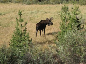
It wound up being a 13 mile dayhike and everyone was tired. The Winds don't have many great day hikes but that's what I'd agreed to. Obviously we weren't going to Photographer's Point if we were passing it on the way to Titcomb. One hike I do enjoy is heading to the Natural Bridge on Clear Ck. So we headed back up Rt 351 the next day to the Green River Lakes TH. It was a pleasant day and an easy 8 mile dayhike. Even a moose sighting.


Everyone enjoyed the day and we headed back to Pinedale. The backpack was to start early the next day. The weather had a massive cold front coming in that evening. High winds were expected with wind chills in the backcountry predicted in the teens/single-digits. Talked it over with the folks at GOS and decided we'd delay the departure a day to let the storm pass. With not many options for day hikes, I decided we'd just do the long road trip to Big Sandy and hike as far as we could.
Shortly after dinner sleet started in town with winds howling all night. But the morning brought bright skies even though it was cold. We packed into my SUV and headed to Big Sandy. Shortly after starting the climb to the trail head we found the road blocked.

A camper was using his truck to help clear the road so we pitched in as best we could. But it was clear that it was more than just a few trees blocking the road. About an hour later the Forest Service crew came in and started clearing the road. We stayed out of the way but helped with the smaller debris and followed them up to the trailhead.

Everyone was in high spirits despite all of this. Might of been a high point so far! There were a few flurries that came through but we were going in. Navigating through the downfall, especially near the trailhead was tedious, but after awhile, we got fairly adept at finding paths through the maze. The owner of this vehicle was lucky it wasn't worse:


We finally made it to a meadow opening after about 2 hrs. It was around 2 pm so it was time for lunch and start heading back to get ready for the backpack. I checked in at GOS and learned the extent of the devastation. All major trail heads were gone. There was no way we would be able to get to Titcomb in the time we had left. Green River was also said to have 100's of trees across the trail.
That would be a huge disappointment, having planned this for a year and with the group making extra effort to be here in spite of a pandemic. I asked about Scab Creek at GOS but no one had any information. Just to expect the same everywhere. I thought I might salvage a decent 3 day backpack if we could make it to Middle Fork Basin. All that was known was that the FS crews were concentrating on getting the major trail heads open first.
So, I headed back to the motel to break the news. No Titcomb. Best shot was going in at Scab Creek. Comments went from “Go to the Tetons instead” and “Is it going to be any good?” to “Whatever you think”. Eventually, all agreed to go with my plan, especially after the motel owner said Scab Ck was his favorite trail head.
We got an early start, and found the trail in comparatively decent shape. I was pushing the pace again, hoping to reach Rainbow L the first day, then loop through Bonneville or Middle Fk. We stopped to take photos of a pair of moose and met a few groups of hikers exiting. We heard stories of trying to survive the storm with trees crashing a few feet from tents and extreme cold.

While we took few breaks, it was clear that we weren't going to make Rainbow L in time. Decided to base camp near Dream L and do a day hike to Rainbow Pass. At least we were far enough in that I could be certain that they would have good views on their first Winds backpack.


I found a good area to camp on a knoll just west of the trail near Dream Lake. Everyone was thrilled with the location. Frankly, it had much better views than my original idea of Rainbow L, though less sheltered. We made dinner and enjoyed a great sunset.


It was frosty the next morning. A few were up early enjoying the cold morning sunrise. We got a late start (my fault – getting slow in my old age).


Headed up towards Rainbow L and the pass. I had to push the pace again. Kept telling everyone to hold off lunch until we reached the pass. They were blown away by the view. Everyone agreed it was well worth it.


On the return the group went on when I stopped for water. My pace had been too fast. Still hadn't seen them when I reached the unsigned junction at the top of Rainbow L. Spent 5-10 min calling out then decided I'd have to move on. Wasn't happy about losing everyone. While they had experience, I felt responsible for their safety. I was also the only one with a gps map and knowledge of the area.
About a ¼ mile around the lake I heard yelling from behind. It was a big relief to have found the group but I was still on edge that we'd gotten separated that long. The “junction” has many trails around a knoll and willows. They had gone on the far side and sat by the creek expecting me to come the same way. Couldn't hear me yelling due to the creek. I kept us together after that.

We enjoyed another night at camp and left early the next morning. It's always less exciting to be headed out but the group was headed home the next day. We took a few more photos and had an uneventful exit until we met a few inbound hikers who informed us of a recent moose kill. The carcass was just off the trail. Told everyone to stay close and be on the lookout as we'd like to get past that before Mr. Bear came to feed on the leftovers. I spotted the carcass, with only crows around so hustled everyone through. No photos. Unfortunately, it the bull moose we had spent so much time photographing on the way in.


We said our goodbyes to the group the next day and headed to Lander. I let my girlfriend choose between a backpack to Stough Ck basin or a longer hike to the Deep Lakes with an ascent of Windy Mtn. She chose the latter-might have been regretting it after a long 10 mile the first day. Nothing steep but it's constant up.


Unfortunately, the smoke had returned and visibility was poor. We paused about a half mile from the top of Windy and returned. I tried fishing the lake but no takers. Some minuscule gnat was on the water. Maybe the right imitation would have worked, but I don't have the patience or eyesight to tie on size 22's.

We returned to Dubois, day hiked Lake Louise then headed for GTNP and the luxury of a cabin at Colter Bay. We took a day trip to Yellowstone but only went as far as Geyser Basin. Did get to see a griz off in the distance. Waited around to try and photograph Old Faithful from a different angle, but weather made for so-so shots.


The next day was partially spent packing. Then we hiked about 4 hours along the lake. Several deer kindly posed for many photos, totally unconcerned with our presence. Made dinner ourselves since the takeout menus didn't have much of interest. We did indulge in some ice cream from the store however!


I had a remaining week solo. Not being the type to give up easy, I headed back to Lander and up the same trails I took the first week. Still hoping to catch a golden. This time I targeted a lake lower in the chain, but again it was “breezy.” Far too breezy at those temps to be remotely comfortable fishing. Left the lake and tried the stream below where I could see several fish. But they were highly skittish and not taking what I was offering. After a few hours I gave it up, returned to camp and was content catching a few brookies. With no improvement in the weather, I headed out the next day. Found what might be bear scat on the return.


I was curious as to how the west side trails were 2 weeks after the storm. The crews had done an amazing job. I first went to Photographer's Point. In many sections the downfall was over 10 feet high. Trees with diameters more than 2 feet had been cleared.


I spent a few days fishing the Upper Green R. Landed 2 monster browns from my favorite hole.

Wasn't able to capture the “Whoa!” moment when this guy turned the corner and was inches away from the moose. He coolly but hastily retreated.

I ventured back to Big Sandy and went almost as far as Deep Ck lake before turning around. The herd trail that we had started was well established. The clearing was great for the first half mile, then I guess they decided the herd trail was good enough.


Until next time...

Talked about my annual trips to Wyoming and the Winds when I joined a local hiking group about 5 yrs ago. The leader asked “What's so special about the Wind Rivers?” A bit surprised she hadn't heard of it as she's been to Yellowstone, I said something like “There's photos online but you sort of have to experience it.” So, I got asked to help plan a trip there.
It took years as the group already had plans for backpacks in Banff, Mt. Whitney, Sequoia, and Patagonia. Then the leaders agreed that it was time for the Winds in 2020. It was a photo of Titcomb Basin that triggered it. “I want to see that!” (Yeah, I know... that and the Cirque. But it's their first trip).
Spent weeks planning options. We were limited to 15 and had to get a permit. I set it for September 6-13. The leader required 2 day hikes to acclimate before the backpack. These are solid hikers so I figured we could get to near Island L day 1, explore the Basin and Peak L then head out. Worked with the FS to find a good base camp near but not at Island L.
I also wanted a week to myself to chase golden trout, my girlfriend wanted to come on the group hike and spend another week by ourselves. My nephew also wanted to come for 10 days. 4 different agendas to create and coordinate.
We posted the trip in October. Everyone was required to purchase airfare and reserve motel rooms by March. The trip filled almost immediately, with 10 others on the wait list.
Then COVID-19 hit.
June saw the first cancellation. Wyoming's rate remained low - one of the few states not on the mandatory quarantine list. By mid July all but 6 had canceled, including the leader and all co-leaders. My nephew also canceled since his employer had travel restrictions.
The rest braved it out. Kept checking COVID data for WY hoping that it would remain off the quarantine list. The first person to cancel rejoined. 2 others had to cancel for family and health reasons.
My plan:
Week 1: Solo – search for golden trout in Popo Agie, GF arrives – acclimation hikes near Dubois
Week 2: Group arrives in Pinedale. 2 acclimation hikes, 4 day backpack
Week 3: GF and myself – backpack to Deep Ck Lakes, climb Wind River Peak. Then Dubois and GTNP
Week 4: Solo – More golden trout finding in the Popo Agie, fish the upper Green
Air travel was indeed strange, especially an international airport that is mostly empty in late August.
The drive from Salt Lake to Pinedale was uneventful, though new as I usually fly directly to Jackson. I stayed overnight in my mobile motel room.
Showered at the Pinedale Aquatic Center, checked the Great Outdoor Shop for conditions and headed to Lander. Both Lander and Pinedale were crowded. With 2 nights of acclimation and a trail that wasn't too elevated I felt good enough to start. Packed for 3 nights out as I needed to be in Dubois to set up camp for my girlfriend. Total weight was about 27 lbs.
Struck up a conversation at the trail head with a guy parked next to me. Found we were headed for the same drainage. He was taking a mostly off-trail, shorter route while I was staying on trail for as long as possible. Made plans to rendezvous at a small lake both of us had identified as a good base camp. I made good time, stopping a few times for water and a quick lunch. Did a different off-trail section this trip vs the 2 prior visits so that slowed me down.
Did not encounter anyone else though did see this print. Might be too small for wolf?
We arrived near the campsite at the same time. The small lake was full of willing brook trout.
Found a spot in the trees. Kevin found an established spot that was much larger and had a fire ring.
I had originally wanted to target a lower lake known to have golden. On 2 other trips I came up empty. Kevin wanted to try a lake located higher so I was happy to explore it. We set out at 9 and traveled cross country to a edge of a large boulder field. There was a small lake but may have been too small to contain fish so we started up the boulder field.
We reached the target lake around noon. Forecast said “breezy”. Winds were sufficiently “breezy” to have frequent whitecaps. Temps were in the mid-40's – not the most pleasant conditions. We fished different sections for about 2 hr without success.
We traveled back to camp, caught plenty of brook trout sheltered from the wind. Since the wind was supposed to pick up the next day we decided to bag it. We were to meet at 8 and travel together to the trail head. I showed up at Kevin's site at 8 the next morning to find him already gone. Found a note on my windshield with contact info for another attempt in 2021. Looking at the time on the dash, I found my phone was an hour off. Ugh...I pride myself on being on time! Glad we went together. It was good to discuss different routes, particularly up that boulder shoot.
I took off the next day for Dubois and the Longhorn campground. I wanted to do a day hike to 5 Pockets from Parque Ck Road. It's a place I hadn't seen in many years. Decided to scout the road to the trailhead based on conversations with Absorkanaut. I arrived at an intersection to find this:
So much for that idea. We could have started several miles below at a different trail head, but a 12 mile acclimation hike wasn't a good idea. Decided we'd go to Wiggin's Fk at Double Cabin CG and then do a loop on Jade/Upper Jade at Brooks Lake the day after. She was still struggling with the altitude so we just strolled along the river banks. Lots of warning signs posted:
The next day we hiked around Jade Lakes. Had my first bear encounter was while fishing Upper Jade long ago. Didn't see anyone on that trip. This time, the trails were full of hikers. Some much needed rain temporarily cleared the skies of haze from the fires.
Met the group in Pinedale the following day. We ordered take out and ate on the banks of Pine Ck in the town park where I reviewed the itinerary. The haze in the air obscured the views of the mountains on their drive, but everyone was in high spirits. I suggested we drive to a viewpoint to watch the sunset. It was great to see their reactions to seeing the Winds up close.
We were off early for the first acclimation hike – a level route along New Fork Lake. I hadn't done that route before and was hoping we could get to an open view of the canyon before turning around. So, I pushed the pace. Shortly after the second crossing, we broke out into a meadow with good views and decided that's good enough.
It wound up being a 13 mile dayhike and everyone was tired. The Winds don't have many great day hikes but that's what I'd agreed to. Obviously we weren't going to Photographer's Point if we were passing it on the way to Titcomb. One hike I do enjoy is heading to the Natural Bridge on Clear Ck. So we headed back up Rt 351 the next day to the Green River Lakes TH. It was a pleasant day and an easy 8 mile dayhike. Even a moose sighting.
Everyone enjoyed the day and we headed back to Pinedale. The backpack was to start early the next day. The weather had a massive cold front coming in that evening. High winds were expected with wind chills in the backcountry predicted in the teens/single-digits. Talked it over with the folks at GOS and decided we'd delay the departure a day to let the storm pass. With not many options for day hikes, I decided we'd just do the long road trip to Big Sandy and hike as far as we could.
Shortly after dinner sleet started in town with winds howling all night. But the morning brought bright skies even though it was cold. We packed into my SUV and headed to Big Sandy. Shortly after starting the climb to the trail head we found the road blocked.
A camper was using his truck to help clear the road so we pitched in as best we could. But it was clear that it was more than just a few trees blocking the road. About an hour later the Forest Service crew came in and started clearing the road. We stayed out of the way but helped with the smaller debris and followed them up to the trailhead.
Everyone was in high spirits despite all of this. Might of been a high point so far! There were a few flurries that came through but we were going in. Navigating through the downfall, especially near the trailhead was tedious, but after awhile, we got fairly adept at finding paths through the maze. The owner of this vehicle was lucky it wasn't worse:
We finally made it to a meadow opening after about 2 hrs. It was around 2 pm so it was time for lunch and start heading back to get ready for the backpack. I checked in at GOS and learned the extent of the devastation. All major trail heads were gone. There was no way we would be able to get to Titcomb in the time we had left. Green River was also said to have 100's of trees across the trail.
That would be a huge disappointment, having planned this for a year and with the group making extra effort to be here in spite of a pandemic. I asked about Scab Creek at GOS but no one had any information. Just to expect the same everywhere. I thought I might salvage a decent 3 day backpack if we could make it to Middle Fork Basin. All that was known was that the FS crews were concentrating on getting the major trail heads open first.
So, I headed back to the motel to break the news. No Titcomb. Best shot was going in at Scab Creek. Comments went from “Go to the Tetons instead” and “Is it going to be any good?” to “Whatever you think”. Eventually, all agreed to go with my plan, especially after the motel owner said Scab Ck was his favorite trail head.
We got an early start, and found the trail in comparatively decent shape. I was pushing the pace again, hoping to reach Rainbow L the first day, then loop through Bonneville or Middle Fk. We stopped to take photos of a pair of moose and met a few groups of hikers exiting. We heard stories of trying to survive the storm with trees crashing a few feet from tents and extreme cold.
While we took few breaks, it was clear that we weren't going to make Rainbow L in time. Decided to base camp near Dream L and do a day hike to Rainbow Pass. At least we were far enough in that I could be certain that they would have good views on their first Winds backpack.
I found a good area to camp on a knoll just west of the trail near Dream Lake. Everyone was thrilled with the location. Frankly, it had much better views than my original idea of Rainbow L, though less sheltered. We made dinner and enjoyed a great sunset.
It was frosty the next morning. A few were up early enjoying the cold morning sunrise. We got a late start (my fault – getting slow in my old age).
Headed up towards Rainbow L and the pass. I had to push the pace again. Kept telling everyone to hold off lunch until we reached the pass. They were blown away by the view. Everyone agreed it was well worth it.
On the return the group went on when I stopped for water. My pace had been too fast. Still hadn't seen them when I reached the unsigned junction at the top of Rainbow L. Spent 5-10 min calling out then decided I'd have to move on. Wasn't happy about losing everyone. While they had experience, I felt responsible for their safety. I was also the only one with a gps map and knowledge of the area.
About a ¼ mile around the lake I heard yelling from behind. It was a big relief to have found the group but I was still on edge that we'd gotten separated that long. The “junction” has many trails around a knoll and willows. They had gone on the far side and sat by the creek expecting me to come the same way. Couldn't hear me yelling due to the creek. I kept us together after that.
We enjoyed another night at camp and left early the next morning. It's always less exciting to be headed out but the group was headed home the next day. We took a few more photos and had an uneventful exit until we met a few inbound hikers who informed us of a recent moose kill. The carcass was just off the trail. Told everyone to stay close and be on the lookout as we'd like to get past that before Mr. Bear came to feed on the leftovers. I spotted the carcass, with only crows around so hustled everyone through. No photos. Unfortunately, it the bull moose we had spent so much time photographing on the way in.
We said our goodbyes to the group the next day and headed to Lander. I let my girlfriend choose between a backpack to Stough Ck basin or a longer hike to the Deep Lakes with an ascent of Windy Mtn. She chose the latter-might have been regretting it after a long 10 mile the first day. Nothing steep but it's constant up.
Unfortunately, the smoke had returned and visibility was poor. We paused about a half mile from the top of Windy and returned. I tried fishing the lake but no takers. Some minuscule gnat was on the water. Maybe the right imitation would have worked, but I don't have the patience or eyesight to tie on size 22's.
We returned to Dubois, day hiked Lake Louise then headed for GTNP and the luxury of a cabin at Colter Bay. We took a day trip to Yellowstone but only went as far as Geyser Basin. Did get to see a griz off in the distance. Waited around to try and photograph Old Faithful from a different angle, but weather made for so-so shots.
The next day was partially spent packing. Then we hiked about 4 hours along the lake. Several deer kindly posed for many photos, totally unconcerned with our presence. Made dinner ourselves since the takeout menus didn't have much of interest. We did indulge in some ice cream from the store however!
I had a remaining week solo. Not being the type to give up easy, I headed back to Lander and up the same trails I took the first week. Still hoping to catch a golden. This time I targeted a lake lower in the chain, but again it was “breezy.” Far too breezy at those temps to be remotely comfortable fishing. Left the lake and tried the stream below where I could see several fish. But they were highly skittish and not taking what I was offering. After a few hours I gave it up, returned to camp and was content catching a few brookies. With no improvement in the weather, I headed out the next day. Found what might be bear scat on the return.
I was curious as to how the west side trails were 2 weeks after the storm. The crews had done an amazing job. I first went to Photographer's Point. In many sections the downfall was over 10 feet high. Trees with diameters more than 2 feet had been cleared.
I spent a few days fishing the Upper Green R. Landed 2 monster browns from my favorite hole.
Wasn't able to capture the “Whoa!” moment when this guy turned the corner and was inches away from the moose. He coolly but hastily retreated.
I ventured back to Big Sandy and went almost as far as Deep Ck lake before turning around. The herd trail that we had started was well established. The clearing was great for the first half mile, then I guess they decided the herd trail was good enough.
Until next time...
Attachments
Last edited: