Eugene
Member
- Joined
- Mar 13, 2012
- Messages
- 142
I had planned to take my grandson on a hike of the gorgeous Toxaway Pettit lake loop in the Sawtooth wilderness area just south of Stanley Idaho but with the snowy 2016-17 winter, Sunnyside pass was still snow covered as well as some streams were reported as waist deep crossings. Hence we opted for a out and back from Hell Roaring to Lake Imogene.
The hike is a fairly easy hike with an altitude gain of approximately 2000 ft and an 18 mi round trip distance. The area around Stanley is gorgeous with the Sawtooth mountains to the SW and the White Clouds to the SE and the Salmon river in between with Idaho 75 following up the valley towards Sun Valley.
We spent the first night camping at a primitive campground at Pettit Lake. Pettit Lake is a beautiful lake at the base of the mountains.

On Tuesday morning we started the hike using the lower Hell Roaring TH. (the upper TH would save a few miles but the road conditions required a 4 wheel high clearance).

As is normal, the first part of the trail was a dusty trail through a partial burn area with lots of dead trees. The following picture shows why Hell Roaring is a good name.

At about 5 miles we reached Hell Roaring Lake where we crossed the creek and ate lunch.

View of Hell Roaring Lake

Following the trail out of the inlet of Hell Roaring we started up to Lake Imogene. This trail is a well maintained trail although it does gain altitude fairly rapidly at times. Once we approached Lake Imogene we started seeing some snow banks from earlier avalanches.

We set up camp in a small area near the lake planning to day hike up the trail towards the pass over to the north loop of the Toxaway Pettit loop. However we didn't get far before the snow banks became a bit treacherous so we just turned around. Some folks had made it down the pass but they said it was very difficult.
Picture of campsite:

View of Imogene Lake:

Snow bank view:

Crossing the bridge back from Hell Roaring:

We then spent a short day doing a day hike to Sawtooth Lake. It is about 9-10 miles round trip. It is one of the prettiest lakes in the area again with a good elevation gain starting at Iron Creek TH. The lake itself was still 2/3 or so iced over with snow banks on the south side of the lake. Here are a few pictures:
Sawtooth view:

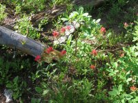
Some wildflowers:
View of lake Alpine:

A couple of pictures of Sawtooth Lake:


I know the following pictures don't really belong here but we did a short river raft trip following the hike. Here are a couple of pictures from this excursion.


In summary there are lots of hikes with gorgeous scenery in the area. It is about 3 hr NE of Boise ID.
The hike is a fairly easy hike with an altitude gain of approximately 2000 ft and an 18 mi round trip distance. The area around Stanley is gorgeous with the Sawtooth mountains to the SW and the White Clouds to the SE and the Salmon river in between with Idaho 75 following up the valley towards Sun Valley.
We spent the first night camping at a primitive campground at Pettit Lake. Pettit Lake is a beautiful lake at the base of the mountains.
On Tuesday morning we started the hike using the lower Hell Roaring TH. (the upper TH would save a few miles but the road conditions required a 4 wheel high clearance).
As is normal, the first part of the trail was a dusty trail through a partial burn area with lots of dead trees. The following picture shows why Hell Roaring is a good name.
At about 5 miles we reached Hell Roaring Lake where we crossed the creek and ate lunch.
View of Hell Roaring Lake
Following the trail out of the inlet of Hell Roaring we started up to Lake Imogene. This trail is a well maintained trail although it does gain altitude fairly rapidly at times. Once we approached Lake Imogene we started seeing some snow banks from earlier avalanches.
We set up camp in a small area near the lake planning to day hike up the trail towards the pass over to the north loop of the Toxaway Pettit loop. However we didn't get far before the snow banks became a bit treacherous so we just turned around. Some folks had made it down the pass but they said it was very difficult.
Picture of campsite:
View of Imogene Lake:
Snow bank view:
Crossing the bridge back from Hell Roaring:
We then spent a short day doing a day hike to Sawtooth Lake. It is about 9-10 miles round trip. It is one of the prettiest lakes in the area again with a good elevation gain starting at Iron Creek TH. The lake itself was still 2/3 or so iced over with snow banks on the south side of the lake. Here are a few pictures:
Sawtooth view:
Some wildflowers:
View of lake Alpine:
A couple of pictures of Sawtooth Lake:
I know the following pictures don't really belong here but we did a short river raft trip following the hike. Here are a couple of pictures from this excursion.
In summary there are lots of hikes with gorgeous scenery in the area. It is about 3 hr NE of Boise ID.
")