balzaccom
Member
- Joined
- Sep 30, 2014
- Messages
- 844
With a cabin above Sonora, California, we have a tendency to explore the central part of the Sierra: Yosemite, Emigrant Wilderness, Carson-Iceberg Wilderness, etc. And I do volunteer work in both Desolation and Mokelumne Wildernesses, so those northern areas also get our attention.
But when we decided to go on a hiking trip, we made an effort to get beyond our normal drive time, and headed to Onion Valley, a campground that sits at over 9,000 feet above Independence, CA off Highway 395. It's a seven hour drive from our home, and about five hours from the the cabin. As our good deed for the day, we picked up a PCT hiker at Sonora Pass and delivered him to Bridgeport on our way. And we stopped at the famous Mobil Station in Lee Vining for lunch--a delicious Southwest chicken sandwich for me, a very much less delicious veggie sandwich for M. (Grilled veggies and bread. That's it. The veggies were not completely cooked, they were not seasoned or basted in oil. Just veggies and bread. Hmm.)
We stopped for gas at the Piute Reservation gas station in Bishop, and continued on to Fort Independence, where the local reservation casino had even cheaper gas.
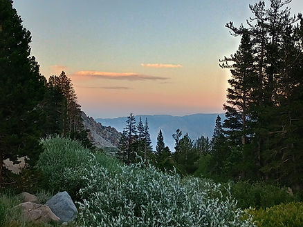
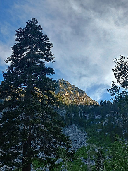
The road up to Onion Valley is an adventure in itself--a twisty, steep uphill slalom run that gains over 5,000 feet in about ten miles. That's impressive. More impressive, in fact, than the campground itself, which is a rough collage of primitive sites with no water and a couple of clean outhouses for thirty sites, all cobbled together around a narrow dirt road. But the views, both from the road and the campground, are spectacular.
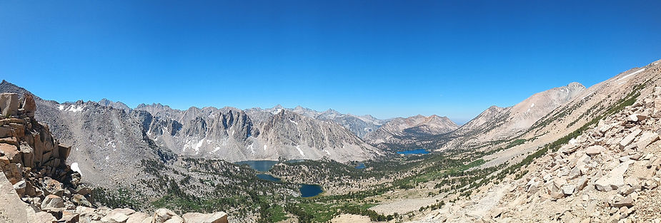
So are the hikes. We took one day to climb up to Kearsarge Pass, at 11,760 feet, to peer into the upper reaches of Bubbs Creek in Kings Canyon National Park. It's an amazing hike that packs stunning views, a fine assortment of lakes, and plenty of fellow hikers into only five miles each way. The reason so many hikers take this trail is that it is one of the best re-supply points on both the John Muir Trail and the Pacific Crest Trail. We met more than a few of each, as well as backpackers tackling shorter trips and dayhikers out to see the sights.
We also ran into a couple of Park Service employees, one of whom was having a bit of an issue with the elevation. We'll tell that story in a future post.
But hiking ten miles, and up and down 2,500 feet, left us feeling our age and our knees. We took our time to re-hydrate, refuel, and rest up after that one. A snooze in the van, a few chats with through-hikers wandering around the campground, and an early dinner followed in short order. And because the east side of the Sierra is so steep, the sun went down behind the mountains on our campsite well before seven p.m. It cooled off, we bundled up, and then we went to bed.
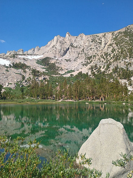
Another day we chose to hike up to Robinson Lake. This short, three-mile round trip hike is on a trail that is described as "not frequently maintained." That is correct. In fact, this trail is damn steep, rocky, and usually chooses to go straight up the side of the mountain, with no thought of working in a switchback to ease the climb. (The Kearsarge Pass Trail, on the other hand, is an absolutely perfect trail--steady slope, beautifully maintained...and only a few high steps to negotiate with our elderly knees.)
We gasped and wheezed our way up to the lake, which is set in a gorgeous bowl of vertical peaks, and then carefully picked our way back down again in time for lunch. Three miles, a thousand feet of climbing, and more scenery to beat the band.
In the afternoon we napped, then drove into Independence to visit the Eastern California Museum, which has a world-class exhibit of Paiute and Shoshone basketry that had us gaping in admiration. Other exhibits include mining, women in the West, and the Owens Valley water project with the LADWP. Well worth a visit, with an excellent gift shop, and free admission! We grabbed an icecream at the Shell station and headed back up the hill for dinner at our campsite.
Once there, our van became a local charging station for a couple of the PCT hikers, whose phones and battery back-ups were running low. Happily, we had the USB ports available, and could help them out.
The last day we were packed up and on the road by 7:30. We were assisted in this by another camper whose car alarm went' off at 6:25 and despite her frantic efforts, kept going for another seven long minutes. (Low battery in her keyfob was the apparent culprit.) And then we were driving north. The original plan was to return to Napa via Yosemite, but in the end we chose to go through Markleeville and Echo Summit. More on that in a future post, too.
The trip was a great reminder that the Sierra gets higher and steeper and more impressive as you go south. The trail to Robinson Lake was a good reminder that trails like Taboose and Baxter Passes have earned their fearsome reputation. And we do need to go back, to see more, do more, and enjoy more of that part of the Sierra.
Here'sthe photo link to them all: https://photos.app.goo.gl/uUoqRQbgj3T291Rc9
But when we decided to go on a hiking trip, we made an effort to get beyond our normal drive time, and headed to Onion Valley, a campground that sits at over 9,000 feet above Independence, CA off Highway 395. It's a seven hour drive from our home, and about five hours from the the cabin. As our good deed for the day, we picked up a PCT hiker at Sonora Pass and delivered him to Bridgeport on our way. And we stopped at the famous Mobil Station in Lee Vining for lunch--a delicious Southwest chicken sandwich for me, a very much less delicious veggie sandwich for M. (Grilled veggies and bread. That's it. The veggies were not completely cooked, they were not seasoned or basted in oil. Just veggies and bread. Hmm.)
We stopped for gas at the Piute Reservation gas station in Bishop, and continued on to Fort Independence, where the local reservation casino had even cheaper gas.
The road up to Onion Valley is an adventure in itself--a twisty, steep uphill slalom run that gains over 5,000 feet in about ten miles. That's impressive. More impressive, in fact, than the campground itself, which is a rough collage of primitive sites with no water and a couple of clean outhouses for thirty sites, all cobbled together around a narrow dirt road. But the views, both from the road and the campground, are spectacular.
So are the hikes. We took one day to climb up to Kearsarge Pass, at 11,760 feet, to peer into the upper reaches of Bubbs Creek in Kings Canyon National Park. It's an amazing hike that packs stunning views, a fine assortment of lakes, and plenty of fellow hikers into only five miles each way. The reason so many hikers take this trail is that it is one of the best re-supply points on both the John Muir Trail and the Pacific Crest Trail. We met more than a few of each, as well as backpackers tackling shorter trips and dayhikers out to see the sights.
We also ran into a couple of Park Service employees, one of whom was having a bit of an issue with the elevation. We'll tell that story in a future post.
But hiking ten miles, and up and down 2,500 feet, left us feeling our age and our knees. We took our time to re-hydrate, refuel, and rest up after that one. A snooze in the van, a few chats with through-hikers wandering around the campground, and an early dinner followed in short order. And because the east side of the Sierra is so steep, the sun went down behind the mountains on our campsite well before seven p.m. It cooled off, we bundled up, and then we went to bed.
Another day we chose to hike up to Robinson Lake. This short, three-mile round trip hike is on a trail that is described as "not frequently maintained." That is correct. In fact, this trail is damn steep, rocky, and usually chooses to go straight up the side of the mountain, with no thought of working in a switchback to ease the climb. (The Kearsarge Pass Trail, on the other hand, is an absolutely perfect trail--steady slope, beautifully maintained...and only a few high steps to negotiate with our elderly knees.)
We gasped and wheezed our way up to the lake, which is set in a gorgeous bowl of vertical peaks, and then carefully picked our way back down again in time for lunch. Three miles, a thousand feet of climbing, and more scenery to beat the band.
In the afternoon we napped, then drove into Independence to visit the Eastern California Museum, which has a world-class exhibit of Paiute and Shoshone basketry that had us gaping in admiration. Other exhibits include mining, women in the West, and the Owens Valley water project with the LADWP. Well worth a visit, with an excellent gift shop, and free admission! We grabbed an icecream at the Shell station and headed back up the hill for dinner at our campsite.
Once there, our van became a local charging station for a couple of the PCT hikers, whose phones and battery back-ups were running low. Happily, we had the USB ports available, and could help them out.
The last day we were packed up and on the road by 7:30. We were assisted in this by another camper whose car alarm went' off at 6:25 and despite her frantic efforts, kept going for another seven long minutes. (Low battery in her keyfob was the apparent culprit.) And then we were driving north. The original plan was to return to Napa via Yosemite, but in the end we chose to go through Markleeville and Echo Summit. More on that in a future post, too.
The trip was a great reminder that the Sierra gets higher and steeper and more impressive as you go south. The trail to Robinson Lake was a good reminder that trails like Taboose and Baxter Passes have earned their fearsome reputation. And we do need to go back, to see more, do more, and enjoy more of that part of the Sierra.
Here'sthe photo link to them all: https://photos.app.goo.gl/uUoqRQbgj3T291Rc9
