ogdendude
Member
- Joined
- Apr 19, 2013
- Messages
- 86
So I know there is already a trip report on this location, but I thought I'd give my own experience. I thought about just adding to the existing string, but I was reminded that if I post a TR then I qualify for the sleeping bag. So here goes.
I was looking for a quickie trip to a place I'd never seen before. I have the book "Ruins Seldom Seen" and it suggested Hammond Canyon, so I thought I'd give it a go.
I drove down to Blanding getting in around 11pm Friday night and I stayed in a motel. I can't stand Blanding since there is no decent place to eat and it is a totally dry town. On the other hand, it is conveniently located near Cedar Mesa, Dark Canyon, Comb Ridge and a bunch of other cool places. So I just take Blanding for what it is, spend the night, gas up and then leave.
I drove out around 8am Saturday morning thinking I have the whole day and no need to rush. I left Blanding on the road which is one block north of Edge of the Cedars State Park.
A WORD ABOUT MAPS:
On this trip I was amazed at how many little differences on the ground I found compared to the map I had (National Geographic Manti La Sal National Forest). I don't think it is National Geographic's fault since I checked it against USGS maps and they were the same. I think in some cases that trails on the ground are moved, roads are moved and in other cases there are more than one name and/or number for a road. And in some cases I think the USGS is just wrong. I found this to be slightly confusing at times and ended up trusting my sense of direction over maps.
So in Blanding this road may be called 550 N.
But on some maps I have seen it as Westwater Road and Elk Mountain Road or South Elks Road. It is also called 268. This road is mostly good for any car, but I did have to cross a creek, which in a lower car might be tricky.
So then this road merges with Cottonwood Road, also known as 092 or 92 or 106.
Then you leave Cottonwood road and return on South Elks Road continuing west on 092 or 92.
Along this road I stopped off at Over Under Ruin. I met another guy here who was by himself. He was exploring this area looking for other sites in the same canyon.
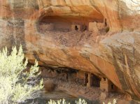
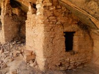
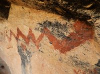
So then back westward on South Elks Road or 92 or 092 I ran into a bunch of people in these three really big trucks, along with about 20 dogs, and a lot of guns. I wish I could have taken a picture of these guys. They were pretty much out of central casting of what people against the NRA think that people who are in the NRA look like. I stopped and talked to them and asked them what they were hunting. They said "bears".
Bear hunting? No shit?
One told me "I've been waiting 12 years for my bear permit".
Then he tells me that each of his dogs has a GPS collar on and he can track where his dogs are on his computer and see if they are flushing out a bear.
I asked him what he does with the bear once he kills it and he told me they make good burgers. As well as the fur skin and trophy head.
Who knew?
So then I drove out 92 or 092 a bit further looking at the many roads that spur off to each side. I could tell that some roads on the maps barely exist at all on the ground. Some roads which are well established roads on the ground don't exist on the maps. And some roads are in slightly different places on the ground than they are on the maps.
I drove out one side spur clearly not on my map which has a huge sign indicating "Hammond Canyon Overlook". So I went out there past the pine forest and into the burn area and from there you could get a great view down into Hammond Canyon as well as across to Blue Mountain.
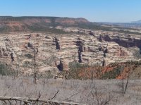
Notice the burn in the foreground.
So then I went back to road 92 or 092 until I hit a major junction with 88 or 088. Here there is a large sign pointing in the direction of "The Notch" to the north.
So then I take 88 or 088 North for a short distance to the intersection of the Peavine Canyon Corridor Road aka 089. There is a vault toilet here so I took advantage of the last toilet I'd see for the next 24 hours.
This road 88 or 088 connects all the way to Cathedral Butte, the Salt Creek TH, and eventually the Needles visitor center if you kept going.
On all the maps I have it shows the Hammond Canyon TH as being before (south of) the Peavine Road. But in fact the Hammond Canyon TH is well past (north of) the Peavine Road. I assume that the Hammond Trail moved a long time ago since the new TH and parking area is well established.
The Hammond Canyon TH is at a place called "LIttle Notch" which has a large sign telling you so, not to be confused with "The Notch". At this TH there are a couple of very nice campsites if you wanted to spend the night here before heading down. The trail is numbered 012. There was no register book and no information sign at all.
I then headed down the Hammond Canyon trail. I did notice that the trail doesn't seem to follow the same route on the ground as the topo shows it. Doesn't really matter since it gets you to the same place, but it is interesting that at some point they moved the trail.
The total elevation drop between the TH and Three Fingers Creek (my name, being the creek that comes down from the Three Fingers drainage where the Three Fingers rock and Three Fingers Ruin are) is about 1900 feet. 1500 feet of that 1900 happens in the first 2 miles. There isn't much in the way of switchbacking the way one might see in the Uintas. This trail is more or less straight down with some short switchbacks some as short as 10 feet long per switch. Along the upper part of the trail you see a small barbed wire corral, a tree stand, a trough, as well great views of the surrounding cliffs.
When you get to the bottom of the steep section you are greeted with a view of a giant phallus.
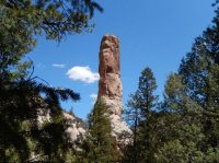
You are also greeted with shade. Much of the upper part of the trail is in the sun, but down in the canyon you get shade from the pine trees.
I was really surprised when I got to the canyon bottom. First of all, the trail looked very lightly used. For the most part I was walking on a bed of pine needs and pine cones and not a well trod path. I also saw tons of various game track and very little of anything that looked human. Also, the path has a lot of up and down as one crosses the stream bed several times. So it is not a flat canyon bottom like Salt Creek. There was no water in the stream bed the first several times I crossed it, and then the farther down canyon you get the more the stream becomes a stream.
The major landmark to tell you when you are very close is the waterfall.
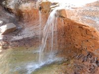
The other big surprise for me was that I never really saw much in the way of established campsites anywhere. If one is to follow the rules about not camping near water nor near the trail then you'd be out of luck. I couldn't see any established places to camp that fit the rules.
So, now that I got this far the trick is, exactly where is the ruin and what is the best way to find it? So here is my guidance:
Walk past the waterfalls about 400 yards until the main creek meets another creek coming in from the left (from the north). At this exact spot the trail and the creek cross a wide area of smooth rock where everything around it is sand and dirt. So this spot should be very identifiable.
Also, when I did this there was a huge tree lying across the trail 100 yards before this. So either the tree is still there or evidence that it has been cut. Either, way, stop exactly where these two creeks meet and where the trail and creek cross a wide flat smooth piece of rock layer.
At this spot look up NNE and this is your view:
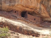
OK, so this is with a telephoto lens. But I took this from the trail on the canyon floor where it hits the flat rock stream bed at the confluence of the two creeks. The ruins are very visible to the naked eye from the trail on the canyon floor.
From here walk up the smaller stream bed which comes in from your left (the north). This stream bed has a few trees across it, and stones to step over, but from what I could tell this was the best way compared to bush whacking on either side.
Then a few hundred yards up this stream on the right I found a faint "trail" or route which basically goes straight up the side of this slope towards the ruin. You can see the ruin most of the way so you can always orient yourself to it. This slope is not an easy climb as there isn't a trail to speak of, it's pretty steep, and it's 500 feet.
I recommend hiking back up the 1900 feet first thing in the morning before it gets warm. I did this and then drove around looking at some pretty cool views such as this:
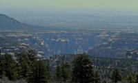
Arch Canyon overlook
I drove out Bears Ears on 88 or 088. There is one spot here which can be very muddy when it rains. So be careful about the 88 junction with 108.
RESOURCES:
http://www.ruinsseldomseen.com/Hammond_Cyn.html
THING TO REMEMBER:
Bear spray.
Featured image for home page:
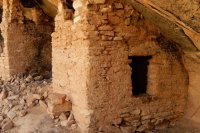
I was looking for a quickie trip to a place I'd never seen before. I have the book "Ruins Seldom Seen" and it suggested Hammond Canyon, so I thought I'd give it a go.
I drove down to Blanding getting in around 11pm Friday night and I stayed in a motel. I can't stand Blanding since there is no decent place to eat and it is a totally dry town. On the other hand, it is conveniently located near Cedar Mesa, Dark Canyon, Comb Ridge and a bunch of other cool places. So I just take Blanding for what it is, spend the night, gas up and then leave.
I drove out around 8am Saturday morning thinking I have the whole day and no need to rush. I left Blanding on the road which is one block north of Edge of the Cedars State Park.
A WORD ABOUT MAPS:
On this trip I was amazed at how many little differences on the ground I found compared to the map I had (National Geographic Manti La Sal National Forest). I don't think it is National Geographic's fault since I checked it against USGS maps and they were the same. I think in some cases that trails on the ground are moved, roads are moved and in other cases there are more than one name and/or number for a road. And in some cases I think the USGS is just wrong. I found this to be slightly confusing at times and ended up trusting my sense of direction over maps.
So in Blanding this road may be called 550 N.
But on some maps I have seen it as Westwater Road and Elk Mountain Road or South Elks Road. It is also called 268. This road is mostly good for any car, but I did have to cross a creek, which in a lower car might be tricky.
So then this road merges with Cottonwood Road, also known as 092 or 92 or 106.
Then you leave Cottonwood road and return on South Elks Road continuing west on 092 or 92.
Along this road I stopped off at Over Under Ruin. I met another guy here who was by himself. He was exploring this area looking for other sites in the same canyon.


So then back westward on South Elks Road or 92 or 092 I ran into a bunch of people in these three really big trucks, along with about 20 dogs, and a lot of guns. I wish I could have taken a picture of these guys. They were pretty much out of central casting of what people against the NRA think that people who are in the NRA look like. I stopped and talked to them and asked them what they were hunting. They said "bears".
Bear hunting? No shit?
One told me "I've been waiting 12 years for my bear permit".
Then he tells me that each of his dogs has a GPS collar on and he can track where his dogs are on his computer and see if they are flushing out a bear.
I asked him what he does with the bear once he kills it and he told me they make good burgers. As well as the fur skin and trophy head.
Who knew?
So then I drove out 92 or 092 a bit further looking at the many roads that spur off to each side. I could tell that some roads on the maps barely exist at all on the ground. Some roads which are well established roads on the ground don't exist on the maps. And some roads are in slightly different places on the ground than they are on the maps.
I drove out one side spur clearly not on my map which has a huge sign indicating "Hammond Canyon Overlook". So I went out there past the pine forest and into the burn area and from there you could get a great view down into Hammond Canyon as well as across to Blue Mountain.

Notice the burn in the foreground.
So then I went back to road 92 or 092 until I hit a major junction with 88 or 088. Here there is a large sign pointing in the direction of "The Notch" to the north.
So then I take 88 or 088 North for a short distance to the intersection of the Peavine Canyon Corridor Road aka 089. There is a vault toilet here so I took advantage of the last toilet I'd see for the next 24 hours.
This road 88 or 088 connects all the way to Cathedral Butte, the Salt Creek TH, and eventually the Needles visitor center if you kept going.
On all the maps I have it shows the Hammond Canyon TH as being before (south of) the Peavine Road. But in fact the Hammond Canyon TH is well past (north of) the Peavine Road. I assume that the Hammond Trail moved a long time ago since the new TH and parking area is well established.
The Hammond Canyon TH is at a place called "LIttle Notch" which has a large sign telling you so, not to be confused with "The Notch". At this TH there are a couple of very nice campsites if you wanted to spend the night here before heading down. The trail is numbered 012. There was no register book and no information sign at all.
I then headed down the Hammond Canyon trail. I did notice that the trail doesn't seem to follow the same route on the ground as the topo shows it. Doesn't really matter since it gets you to the same place, but it is interesting that at some point they moved the trail.
The total elevation drop between the TH and Three Fingers Creek (my name, being the creek that comes down from the Three Fingers drainage where the Three Fingers rock and Three Fingers Ruin are) is about 1900 feet. 1500 feet of that 1900 happens in the first 2 miles. There isn't much in the way of switchbacking the way one might see in the Uintas. This trail is more or less straight down with some short switchbacks some as short as 10 feet long per switch. Along the upper part of the trail you see a small barbed wire corral, a tree stand, a trough, as well great views of the surrounding cliffs.
When you get to the bottom of the steep section you are greeted with a view of a giant phallus.

You are also greeted with shade. Much of the upper part of the trail is in the sun, but down in the canyon you get shade from the pine trees.
I was really surprised when I got to the canyon bottom. First of all, the trail looked very lightly used. For the most part I was walking on a bed of pine needs and pine cones and not a well trod path. I also saw tons of various game track and very little of anything that looked human. Also, the path has a lot of up and down as one crosses the stream bed several times. So it is not a flat canyon bottom like Salt Creek. There was no water in the stream bed the first several times I crossed it, and then the farther down canyon you get the more the stream becomes a stream.
The major landmark to tell you when you are very close is the waterfall.

The other big surprise for me was that I never really saw much in the way of established campsites anywhere. If one is to follow the rules about not camping near water nor near the trail then you'd be out of luck. I couldn't see any established places to camp that fit the rules.
So, now that I got this far the trick is, exactly where is the ruin and what is the best way to find it? So here is my guidance:
Walk past the waterfalls about 400 yards until the main creek meets another creek coming in from the left (from the north). At this exact spot the trail and the creek cross a wide area of smooth rock where everything around it is sand and dirt. So this spot should be very identifiable.
Also, when I did this there was a huge tree lying across the trail 100 yards before this. So either the tree is still there or evidence that it has been cut. Either, way, stop exactly where these two creeks meet and where the trail and creek cross a wide flat smooth piece of rock layer.
At this spot look up NNE and this is your view:

OK, so this is with a telephoto lens. But I took this from the trail on the canyon floor where it hits the flat rock stream bed at the confluence of the two creeks. The ruins are very visible to the naked eye from the trail on the canyon floor.
From here walk up the smaller stream bed which comes in from your left (the north). This stream bed has a few trees across it, and stones to step over, but from what I could tell this was the best way compared to bush whacking on either side.
Then a few hundred yards up this stream on the right I found a faint "trail" or route which basically goes straight up the side of this slope towards the ruin. You can see the ruin most of the way so you can always orient yourself to it. This slope is not an easy climb as there isn't a trail to speak of, it's pretty steep, and it's 500 feet.
I recommend hiking back up the 1900 feet first thing in the morning before it gets warm. I did this and then drove around looking at some pretty cool views such as this:

Arch Canyon overlook
I drove out Bears Ears on 88 or 088. There is one spot here which can be very muddy when it rains. So be careful about the 88 junction with 108.
RESOURCES:
http://www.ruinsseldomseen.com/Hammond_Cyn.html
THING TO REMEMBER:
Bear spray.
Featured image for home page:

