Navigation
Install the app
How to install the app on iOS
Follow along with the video below to see how to install our site as a web app on your home screen.
Note: This feature may not be available in some browsers.
More options
You are using an out of date browser. It may not display this or other websites correctly.
You should upgrade or use an alternative browser.
You should upgrade or use an alternative browser.
extra monsoon
- Thread starter regehr
- Start date
fossana
Member
- Joined
- Jan 11, 2018
- Messages
- 876
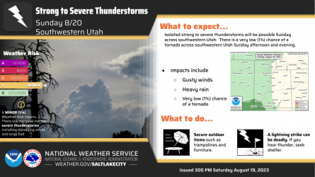
They keep pushing out the flash flood warning around St George. Residential areas in Cedar City flooded this week from the usual monsoons, so I'm sure those folks are dreading any more heavy rain. There are risk maps here if anyone is interested. Vegas at least has flood tunnels, but SoCal is not well equipped for flash floods.
OldBill
Member
- Joined
- Aug 18, 2015
- Messages
- 444
Big current topic for sure! Heading to the Winds Tue 8/22. Daily checks of weather.gov and local weather forecasters (Idaho Falls and Salt Lake) to get overview. Think any flight snarls of Hilary will be gone by Tue and most of the rain gone from region by Wed.
Bigger problem is the long term instability created by the high pressure dome to the east that's pulling monsoon moisture in. Afternoon T-storms predicted/possible through Sat 8/26. @Bob and I intended to be in Bear Basin then but it's 11,000' with no cover. Hoping for a change in jet-stream pattern that shuts off the monsoon.
Moved possible start date back a week and I'm figuring out Plan B for the interim. Rain may blow out front country stream fishing and I'll need plenty of recovery even from short backpack before doing BB, especially with Bob's routes!
fossana
Member
- Joined
- Jan 11, 2018
- Messages
- 876
I've been watching the weather for a few weeks. It has been consistently breezy (up to the 30s mph) or stormy nearly every day. I'm stuck at home for a bit with woodrat-related electrical repairs anyway.Bigger problem is the long term instability created by the high pressure dome to the east that's pulling monsoon moisture in.
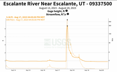
Adding that it looks Escalante got some major rain last week:

Last edited:
- Joined
- Feb 23, 2017
- Messages
- 173
Big current topic for sure! Heading to the Winds Tue 8/22. Daily checks of weather.gov and local weather forecasters (Idaho Falls and Salt Lake) to get overview. Think any flight snarls of Hilary will be gone by Tue and most of the rain gone from region by Wed.
Bigger problem is the long term instability created by the high pressure dome to the east that's pulling monsoon moisture in. Afternoon T-storms predicted/possible through Sat 8/26. @Bob and I intended to be in Bear Basin then but it's 11,000' with no cover. Hoping for a change in jet-stream pattern that shuts off the monsoon.
Moved possible start date back a week and I'm figuring out Plan B for the interim. Rain may blow out front country stream fishing and I'll need plenty of recovery even from short backpack before doing BB, especially with Bob's routes!
Ya. Also headed into Winds for 10 days on Monday(8/28) and plan to be high much of the time. Will see!
OldBill
Member
- Joined
- Aug 18, 2015
- Messages
- 444
Latest Pinedale weather has been getting worse for later this week - gone from 20% to 60% for Fri - Figure 100% high. Just the day I'd planned to start a short loop. Hate hiking all day/s in rain with no views. Tetons & Yellowstone are worse. Feel bad for folks that had trips planned in the Sierras and Utah.Ya. Also headed into Winds for 10 days on Monday(8/28) and plan to be high much of the time. Will see!
Finally found one video said heat dome shrinking and moving south to N Texas on Fri. But still huge factor. Sunday in Pinedale is clear (NWS) so that last week may be OK.
Similar threads
| Thread starter | Title | Forum | Replies | Date |
|---|---|---|---|---|
|
|
Havasu Falls Extra Spot | General Discussion | 3 | |
| J | Mojave National Preserve Monsoon Aug. 3, 2022 | Trip Planning | 2 | |
|
|
Monsoon has Started ! | Trip Planning | 2 | |
|
|
Monsoon Backpackers | General Discussion | 11 |

