HomerJ
Member
- Joined
- Jan 19, 2012
- Messages
- 1,199
There are 3 main trails for climbing the Wellsvilles from the east side. Deep Canyon, Cold Water/Stewart Pass, and Rattlesnake. The Deep Canyon trail begins just west of Mendon. It is 3 miles from the trail head to the ridge and 2700'. Most people rate it strenuous and I would have to agree. There is a lot of stinging nettle in the middle section of the trail that can grow quite' tall. I would recommend to wear pants and possibly a long sleeve shirt. Mid to late June and fall is my favorite time to hike Deep Canyon. The photos in this post are from two separate hikes
The trail very quickly enters the trees and shortly there after starts climbing up the canyon. Here is a map:
View down the canyon


Wild flowers along the trail

About 1/2 way up the trail opens up into a sort of meadow and turns more south. At this point you get your first views of the saddle on top.

Really nice views down into the valley as you near the top of the ridge!

Still snow up here!

I should have brought a sled!!!

On top looking back down into Cache Valley

Bear River Range in the distance. The snowy ridge at the center is Mt Naomi and if you look close you can make out Cherry Peak (just below the biggest cloud) to the left of Naomi

Looking along the ridge to the south. I deiced to hike along the ridge to the peak on the right and then drop back down into Deep Canyon and back.

Wellsville Cone (left) and Box Elder Peak (right)
View down into the Bear River Valley

After taking a few photos I headed south along the ridge to the peak I mentioned before. As I got closer I was supervised to see this rock wall. It looks like it was built as a wind shelter. It is in a "U" shape with the opening being on the other side.

I walked up closer to inspect the rock wall and happened up a Lady Bug gathering! There was 2 or 3 rocks like this. I'm not sure what they were all doing? Mating? Kegger?

Bear River

After eating some snacks I head along the ridge to a saddle just north of the peak with the rock wall. There was a good section of snow and I thought it'd be fun to boot ski down it! Well, as soon as I started going I quickly picked up speed and was flying down the slope. I quickly squatted down on one foot and had the other out in front of me trying to brake. This only caused lots of snow to fly up and into my face! The bare ground below the snow was coming up quick and I braced my self, not knowing what was going to happen! As luck would have it, as I hit the dirt I bounced to my feet into a run to keep from fall and slowed to a stop! PHEW, I had lucked out!!!
  The hillside ended up have a lot of short thick brush so I stayed to a relatively bare ridgeline making my way down. This was slow going as I had to pick my way around the brush. As I got lower it got thicker and worse. Pretty soon I was into the thick tall brush and trees. Eventually I made it back to the trail, but I was scratched and tour up pretty good. I then made a note to myself to not do this again!!
  I made it down the rest of the way and back to the car without any problems.

Featured image for slideshow:

The trail very quickly enters the trees and shortly there after starts climbing up the canyon. Here is a map:
View down the canyon
Wild flowers along the trail
About 1/2 way up the trail opens up into a sort of meadow and turns more south. At this point you get your first views of the saddle on top.
Really nice views down into the valley as you near the top of the ridge!
Still snow up here!
I should have brought a sled!!!
On top looking back down into Cache Valley
Bear River Range in the distance. The snowy ridge at the center is Mt Naomi and if you look close you can make out Cherry Peak (just below the biggest cloud) to the left of Naomi
Looking along the ridge to the south. I deiced to hike along the ridge to the peak on the right and then drop back down into Deep Canyon and back.
Wellsville Cone (left) and Box Elder Peak (right)
View down into the Bear River Valley
After taking a few photos I headed south along the ridge to the peak I mentioned before. As I got closer I was supervised to see this rock wall. It looks like it was built as a wind shelter. It is in a "U" shape with the opening being on the other side.
I walked up closer to inspect the rock wall and happened up a Lady Bug gathering! There was 2 or 3 rocks like this. I'm not sure what they were all doing? Mating? Kegger?
Bear River
After eating some snacks I head along the ridge to a saddle just north of the peak with the rock wall. There was a good section of snow and I thought it'd be fun to boot ski down it! Well, as soon as I started going I quickly picked up speed and was flying down the slope.
I quickly squatted down on one foot and had the other out in front of me trying to brake. This only caused lots of snow to fly up and into my face! The bare ground below the snow was coming up quick and I braced my self, not knowing what was going to happen! As luck would have it, as I hit the dirt I bounced to my feet into a run to keep from fall and slowed to a stop! PHEW, I had lucked out!!! The hillside ended up have a lot of short thick brush so I stayed to a relatively bare ridgeline making my way down. This was slow going as I had to pick my way around the brush. As I got lower it got thicker and worse. Pretty soon I was into the thick tall brush and trees. Eventually I made it back to the trail, but I was scratched and tour up pretty good. I then made a note to myself to not do this again!! I made it down the rest of the way and back to the car without any problems.Featured image for slideshow:
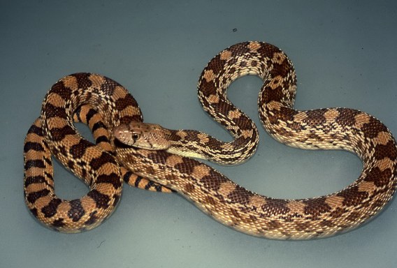
 He was really aggressive and BIG! He eventually left the trail and I was able to get to my car. While driving home I was thinking about that snake and realized he didn't have a rattler on his tail. So when I got home I did some research and found it could be a gopher snake. I pulled up a picture and sure enough, that was what it was.