- Joined
- Dec 5, 2017
- Messages
- 1,387
24 years ago this month, we moved from the East Coast to Michigan. Before moving, I knew very little about the Great Lakes, only that there were 5 lakes with a nice mnemonic for remembering the names (HOMES) and that Thunder Bay along Lake Superior was really buggy (from when we were there in the 1970s). What a delight it has been to explore the Great Lakes, particularly Michigan and Superior. Over the years, we have enjoyed a variety of day hikes and backpacking trips, and we added a new one to our list at the beginning of July, the Coastal Trail in Ontario's Lake Superior Provincial Park.
I had done my homework for this trip, and everyone said that it was beautiful, rugged, much harder than you would expect, and treacherous when wet. I booked our campsites accordingly, and I have to say that everyone was right about everything. We didn't have enough time to do the whole route (perhaps 6 days) so we just did the northern part which was mostly far away from the highway, in contrast to the southern part. Our original plan was to go for 4 nights, but because of bad weather forecasts, both ahead of time and confirmed by our Garmin InReach on Day 3, we only stayed 3 nights. This proved to be the right choice, as storms rolled in as we were driving home.
Rather than doing an out-and-back, we shuttled to the trailhead at Gargantua Bay, hiked south, and left our car near Coldwater Beach in between campsites 3 and 4, which worked out perfectly since we left after campsite 3. We almost had the place to ourselves. We saw two groups of people at the very start, nobody the rest of Day 1, nobody on Day 2 except for one couple late afternoon, and a few couples on Day 3, including when we did an optional loop around an inland lake which people do as a dayhike. Nobody was camped anywhere near us on any of the nights.
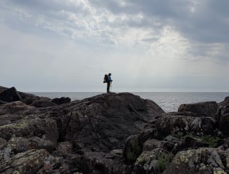
What makes this a hard hike? We constantly went back and forth between the rocky shore and adjacent woods, so we were constantly route finding. I know some on this forum think cairns are problematic, but they are really helpful on this trail. There are blue trail signs in the woods, and the cairns the rangers have placed on the rocks let you know when to go back into the woods. But there were plenty of spots where we had to backtrack and find our way. It wasn't frustrating but was just part of the experience. On the shore, we were rock scrambling most of the time (which was fun), and lots of time in the woods we were climbing up rocks and pulling ourselves up using tree roots. Sometimes the trail was overgrown and we had to backtrack in the woods as well. It was fun but VERY SLOW! I don't record our track while hiking, but based on the expected mileage and the time we spent, I figured sometimes our pace was at least 1.5 hours per mile. Yes, 1.5 hours per mile - that's not a mistake!
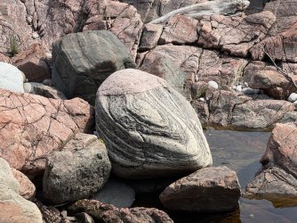
Anyway, the scenery was beautiful and there was tremendous variety - in the woods, up high above the water, down on the rocky shore. I cannot believe how many different kinds of rocks are along this coast - lots of types and lots of sizes, from big jagged boulders all the way down to tiny pebbles.
Day 1
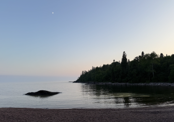
Overcast when we started. Fun rock scrambling!


I'm pretty sure this is mourning cloak.


Rose

Inchworm - larva from geometer moth

Based on the leaf and stem, I thought this might have been in the columbine family. I found out later it's rock harlequin in the bleeding heart family, which made sense based on the top of the flower. I really like wildflowersearch.org for flower ID.

We saw lots of moose droppings, but no moose.

Wild serviceberry


Here comes the sun!


I love these lady's slippers! Ever since reading The Legend of the Lady's Slipper to our kids, I have delighted in seeing them.

Canadian bunchberry, which is in the dogwood family

Twinflower

What is that yellow stuff in the water? Something bad like algal blooms? Pollen? We looked it up later and found out that it's...

Pine pollen - from this!

Lots of beautiful pea flowers along the beach

Rhyolite Cove - such a lovely place to camp. Our site was in the woods just behind this glorious spot.

Day 2
Beautfiul morning!


We loved seeing wild ninebark. We have a different variety of ninebark planted at home, and even though the leaf is a different color, the flower is almost the same.


The white patches are mica reflecting the sun. I had to try multiple times to get them to show up in the photo!

So much variety in the rocks!


Walking here was harder than the rock scrambling.

But walking on the sand was very easy!

This cove was so calm, peaceful.

Very lush in the woods - there has been a LOT of rain this summer!


Sometimes the trail took us way up above the water. We loved the views of the islands and coast off in the distance. Other times, the lake stretched as far as the eye can see, like the ocean.

Lots of treasures for us to find - in the woods...

...and on the rocks

Wood sorrel

Northern starflower


Approaching that night's camp at Sand Spit

The official campsite is in the woods, but we set up our tent on the sand and were so glad we did. You might notice the bug net on my husband. There were lots of mosquitoes, but black flies weren't a problem.

These irises were right at the edge of the woods.


Lovely loons! Ever since reading The Legend of the Loon to our kids, I have wanted to see and hear them.

Beautiful evening


Such a perfect way to end a long, tiring, wonderful day.

Day 3
Always so many great rocks!

More of the pine pollen (that we weren't sure was pollen at the time)

We completely understood why people had said it would be treacherous if wet...

Orange lichen

This tiger swallowtail let me watch it for a long time.

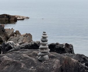
I know some of you don't like cairns, but they were part of the trail signage on this trip. Some park ranger had a good time creating this one!

Lots of primrose along the beach

Lots of fungi in the woods


On previous Great Lakes trips, I had seen the blue berries (inedible) from these bluebead plants and was glad to see the flowers at this time.

Strawberry flowers


For Day 3, I built into our plan some flexibility. If we had time and energy, we would do an optional loop around Orphan Lake, which people can access from a different trailhead. We did this loop and were rewarded with great views of the lake and waterfalls from up high and down low.


According to iphoto, this is Enallagma.

Orange hawkweed

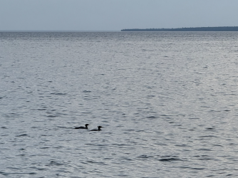
We camped that night in the woods along the beach behind these mergansers. At this spot, we were closer to the road than we would have liked, but fortunately the waves crashing against the rocks made lots of wonderful noise to block the occasional sounds from the road.

This park provides you with pretty nice facilities!

Day 4
This was a short day since we only had to walk a mile to our car. Storms were forecasted, and the waves were bigger than on previous days.


Merganser and Piping Plover

This trip worked out really well for us. We're so glad we went!
I had done my homework for this trip, and everyone said that it was beautiful, rugged, much harder than you would expect, and treacherous when wet. I booked our campsites accordingly, and I have to say that everyone was right about everything. We didn't have enough time to do the whole route (perhaps 6 days) so we just did the northern part which was mostly far away from the highway, in contrast to the southern part. Our original plan was to go for 4 nights, but because of bad weather forecasts, both ahead of time and confirmed by our Garmin InReach on Day 3, we only stayed 3 nights. This proved to be the right choice, as storms rolled in as we were driving home.
Rather than doing an out-and-back, we shuttled to the trailhead at Gargantua Bay, hiked south, and left our car near Coldwater Beach in between campsites 3 and 4, which worked out perfectly since we left after campsite 3. We almost had the place to ourselves. We saw two groups of people at the very start, nobody the rest of Day 1, nobody on Day 2 except for one couple late afternoon, and a few couples on Day 3, including when we did an optional loop around an inland lake which people do as a dayhike. Nobody was camped anywhere near us on any of the nights.
What makes this a hard hike? We constantly went back and forth between the rocky shore and adjacent woods, so we were constantly route finding. I know some on this forum think cairns are problematic, but they are really helpful on this trail. There are blue trail signs in the woods, and the cairns the rangers have placed on the rocks let you know when to go back into the woods. But there were plenty of spots where we had to backtrack and find our way. It wasn't frustrating but was just part of the experience. On the shore, we were rock scrambling most of the time (which was fun), and lots of time in the woods we were climbing up rocks and pulling ourselves up using tree roots. Sometimes the trail was overgrown and we had to backtrack in the woods as well. It was fun but VERY SLOW! I don't record our track while hiking, but based on the expected mileage and the time we spent, I figured sometimes our pace was at least 1.5 hours per mile. Yes, 1.5 hours per mile - that's not a mistake!
Anyway, the scenery was beautiful and there was tremendous variety - in the woods, up high above the water, down on the rocky shore. I cannot believe how many different kinds of rocks are along this coast - lots of types and lots of sizes, from big jagged boulders all the way down to tiny pebbles.
Day 1
Overcast when we started. Fun rock scrambling!
I'm pretty sure this is mourning cloak.
Rose
Inchworm - larva from geometer moth
Based on the leaf and stem, I thought this might have been in the columbine family. I found out later it's rock harlequin in the bleeding heart family, which made sense based on the top of the flower. I really like wildflowersearch.org for flower ID.
We saw lots of moose droppings, but no moose.
Wild serviceberry
Here comes the sun!
I love these lady's slippers! Ever since reading The Legend of the Lady's Slipper to our kids, I have delighted in seeing them.
Canadian bunchberry, which is in the dogwood family
Twinflower
What is that yellow stuff in the water? Something bad like algal blooms? Pollen? We looked it up later and found out that it's...
Pine pollen - from this!
Lots of beautiful pea flowers along the beach
Rhyolite Cove - such a lovely place to camp. Our site was in the woods just behind this glorious spot.
Day 2
Beautfiul morning!
We loved seeing wild ninebark. We have a different variety of ninebark planted at home, and even though the leaf is a different color, the flower is almost the same.
The white patches are mica reflecting the sun. I had to try multiple times to get them to show up in the photo!
So much variety in the rocks!
Walking here was harder than the rock scrambling.
But walking on the sand was very easy!
This cove was so calm, peaceful.
Very lush in the woods - there has been a LOT of rain this summer!
Sometimes the trail took us way up above the water. We loved the views of the islands and coast off in the distance. Other times, the lake stretched as far as the eye can see, like the ocean.
Lots of treasures for us to find - in the woods...
...and on the rocks
Wood sorrel
Northern starflower
Approaching that night's camp at Sand Spit
The official campsite is in the woods, but we set up our tent on the sand and were so glad we did. You might notice the bug net on my husband. There were lots of mosquitoes, but black flies weren't a problem.
These irises were right at the edge of the woods.
Lovely loons! Ever since reading The Legend of the Loon to our kids, I have wanted to see and hear them.
Beautiful evening
Such a perfect way to end a long, tiring, wonderful day.
Day 3
Always so many great rocks!
More of the pine pollen (that we weren't sure was pollen at the time)
We completely understood why people had said it would be treacherous if wet...
Orange lichen
This tiger swallowtail let me watch it for a long time.
I know some of you don't like cairns, but they were part of the trail signage on this trip. Some park ranger had a good time creating this one!
Lots of primrose along the beach
Lots of fungi in the woods
On previous Great Lakes trips, I had seen the blue berries (inedible) from these bluebead plants and was glad to see the flowers at this time.
Strawberry flowers
For Day 3, I built into our plan some flexibility. If we had time and energy, we would do an optional loop around Orphan Lake, which people can access from a different trailhead. We did this loop and were rewarded with great views of the lake and waterfalls from up high and down low.
According to iphoto, this is Enallagma.
Orange hawkweed
We camped that night in the woods along the beach behind these mergansers. At this spot, we were closer to the road than we would have liked, but fortunately the waves crashing against the rocks made lots of wonderful noise to block the occasional sounds from the road.
This park provides you with pretty nice facilities!
Day 4
This was a short day since we only had to walk a mile to our car. Storms were forecasted, and the waves were bigger than on previous days.
Merganser and Piping Plover
This trip worked out really well for us. We're so glad we went!

")
