- Joined
- Aug 9, 2007
- Messages
- 12,967
I've spent most of fall this year running around Utah riding my mountain bike. Not because I'm hugely into mountain biking - yes, it is fun, but more so because my side job of writing trail guides has expanded into also writing up some mountain biking trails around the state. 70 of them to be exact. Well, sort of. A handful of the trails will be paved bike trails and some will be double track routes like the White Rim and Gemini Bridges. I might even get to sneak a few hikes in there. But the majority of them will be classic singletrack routes. In order to get the most trails done in the least amount of time, I recruited my friend @Smokey to help me by coming along. He rides with me sometimes and runs shuttle when trails can be done that way.
Our first big work trip of the season started in Cedar City in early October. We spent the night out at the Three Peaks trails system west of Cedar. We had the place all to ourselves that night. The next day I saddled up and did a few trails. I don't include too many trails shots but here are a few from the Twilight Zone in Three Forks. My skill level is not quite there with the wooden bridges.


After Three Peaks we went and grabbed lunch and then did a couple of paved trails in Cedar City. The Coal Creek Trail had great color going on.

From there we continued east up Cedar Canyon and up to Cedar Breaks National Monument where I walked a new ADA Accessible paved trail that runs from this overlook to the visitor center. The trail itself doesn't have much in the way of views, but the beginning and end are nice.


Next we drove down into Panguitch where we picked up some local firewood and headed east toward Red Canyon. It was a little too late to squeeze in another trail so we went and found this sweet campsite and went for a little hike around camp.


The next day we woke up and headed over to Red Canyon where I rode the paved trail through the canyon. There were a lot of bikers there using it to access the Thunder Mountain Trail. I might come back for that later once I'm more confident.


And after that I rode the Bryce Canyon paved trail that connects Bryce Canyon City to Inspiration Point

Unfortunately the skies were getting increasingly cloudy so the other plans I had nearby were put on ice. At least a little bit of sunshine and blue sky is required for the kind of photos that I need for these trails.
We ended up driving further east, eventually passing through Escalante and Boulder. The clouds blocked the sun completely until we made it out onto the Burr Trail late in the afternoon.
We stopped along the way to hike this sweet little slot canyon.


I absolutely love driving east through amazing landscapes late in the evening with the sun at my back. The Burr trail is perfectly suited for this.

Sage checking out the view where the Burr Trail breaks through the Circle Cliffs


As the day winded down, we made our way out onto the Wolverine Loop to find camp.

We found a nice one.

Wandering around watching the sunset.


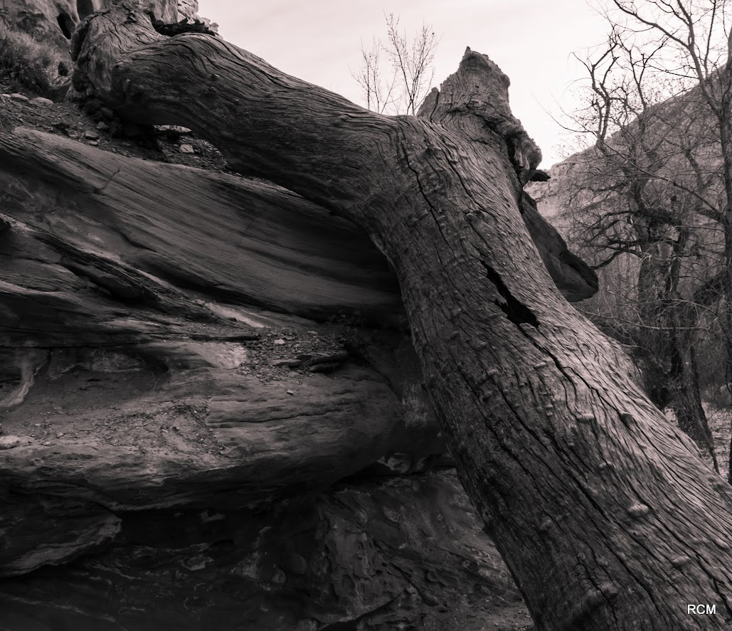
The next day we hiked the Wolverine Natural Wood Area. I had already hiked most of Wolverine but I took another fork to loop back to Little Death Hollow. It was nice to finally see the rest of it.


There wasn't as much petrified wood as I expected. There were some really nice, long pieces, but it isn't as unique to the area as the designation might suggest.


This one might be the girthiest I've ever seen though.


We got back to the truck and finished the Wolverine Loop before heading further east into Capitol Reef.

Nice color on the Burr Trail.

The Burr Trail Switchbacks


Heading north on the Notom Road

Lots of color in Capitol Reef. The main canyon was a mix of green and yellow and very beautiful but I didn't stop for any pictures. It was a productive weekend despite the clouds messing things up for a while.

Our first big work trip of the season started in Cedar City in early October. We spent the night out at the Three Peaks trails system west of Cedar. We had the place all to ourselves that night. The next day I saddled up and did a few trails. I don't include too many trails shots but here are a few from the Twilight Zone in Three Forks. My skill level is not quite there with the wooden bridges.
After Three Peaks we went and grabbed lunch and then did a couple of paved trails in Cedar City. The Coal Creek Trail had great color going on.
From there we continued east up Cedar Canyon and up to Cedar Breaks National Monument where I walked a new ADA Accessible paved trail that runs from this overlook to the visitor center. The trail itself doesn't have much in the way of views, but the beginning and end are nice.
Next we drove down into Panguitch where we picked up some local firewood and headed east toward Red Canyon. It was a little too late to squeeze in another trail so we went and found this sweet campsite and went for a little hike around camp.
The next day we woke up and headed over to Red Canyon where I rode the paved trail through the canyon. There were a lot of bikers there using it to access the Thunder Mountain Trail. I might come back for that later once I'm more confident.
And after that I rode the Bryce Canyon paved trail that connects Bryce Canyon City to Inspiration Point
Unfortunately the skies were getting increasingly cloudy so the other plans I had nearby were put on ice. At least a little bit of sunshine and blue sky is required for the kind of photos that I need for these trails.
We ended up driving further east, eventually passing through Escalante and Boulder. The clouds blocked the sun completely until we made it out onto the Burr Trail late in the afternoon.
We stopped along the way to hike this sweet little slot canyon.
I absolutely love driving east through amazing landscapes late in the evening with the sun at my back. The Burr trail is perfectly suited for this.
Sage checking out the view where the Burr Trail breaks through the Circle Cliffs
As the day winded down, we made our way out onto the Wolverine Loop to find camp.
We found a nice one.
Wandering around watching the sunset.
The next day we hiked the Wolverine Natural Wood Area. I had already hiked most of Wolverine but I took another fork to loop back to Little Death Hollow. It was nice to finally see the rest of it.
There wasn't as much petrified wood as I expected. There were some really nice, long pieces, but it isn't as unique to the area as the designation might suggest.
This one might be the girthiest I've ever seen though.
We got back to the truck and finished the Wolverine Loop before heading further east into Capitol Reef.
Nice color on the Burr Trail.
The Burr Trail Switchbacks
Heading north on the Notom Road
Lots of color in Capitol Reef. The main canyon was a mix of green and yellow and very beautiful but I didn't stop for any pictures. It was a productive weekend despite the clouds messing things up for a while.
")