MJ
New Member
- Joined
- Mar 17, 2014
- Messages
- 2
A couple of buddies and myself hiked up Cat Canyon to Little Horse Heaven, out in the Confusion Range of the West Desert in Utah. We hiked up in the Dark and experienced some navigational challenges, but we did make it up to Little Horse Heaven. Something I haven't really heard of many people actually reaching. It is a pretty cool place, and it wasn't a horribly cold night for the time of year (March 15 2014). I'd recommend this hike as a good overnighter, or maybe even two days if you want to do more exploring and relaxing up top. About 12-13 miles round trip.
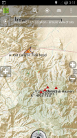
Here are the coordinates for my planned route.
Cat Canyon Trailhead - 39° 5'2.79”N 113°34'24.06”W
Head East - 39° 2'2.03”N 113°33'7.28”W
CheckPoint 1 - 39° 2'11.00”N 113°32'44.64”W
CheckPoint 2 - 39° 2'23.20”N 113°32'28.71”W
Little Horse Heaven - 39° 2'20.54”N 113°31'40.43"W
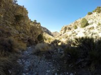
We didn't actually follow this exact route because of the navigational struggles, especially at night. But Ideally you'd actually head up the canyon/stream bed (600 yds-ish) south of where my waypoint is to turn east. That is the way we came back down. It gets steep as you head off of the 4x4 trail, but it is beautiful! Take as much water as you need. We could have melted some snow, as there were patches of snow in the trees, but if your going much later, I doubt you'll have that option.
Feel free to ask me questions if you'd like.
Happy day!
-MJ
(Note: triangles on the map screenshot point north, the compass wasn't working right so ignore the direction the compass says its facing, that is actually what caused a lot of the navigational issues. Though I guess my positional triangle is facing SW... Anyway just be aware of that, look at the topos yourself, etc.)


Last edited:
