- Joined
- May 31, 2015
- Messages
- 3,333
September 27 - October 1, 2025

I took even longer than normal to write this up, somehow. Sitting here at the end of the Winter That Never Was (for the western, non-Alaska US, anyway) has me thinking about backpacking.
This was the 6th year in a row doing a trip in the Bechler area of Yellowstone. The group changes a little every time, but it's always a good time. The plan was to start at the Pitchstone Plateau, then head off trail to the upper reaches of the Bechler drainage, down the headwaters to the main river, and then out at Fish Lake off of Grassy Lake Road. Rec.gov would not let us book the campsites necessary for the route because it limits you based on trail miles between sites or something. A day of 35 or so trail miles from Pitchstone Pleateau to Gregg Fork seemed unfeasible to their system") So Andrew called the backcountry office a while after we had booked the trip to make a few modifications. We ended up getting all the sites we wanted.
So Andrew called the backcountry office a while after we had booked the trip to make a few modifications. We ended up getting all the sites we wanted.
Everyone but me camped out along Grassy Lake Road the night before since we needed to leave a car or two at the ending trailhead for the shuttle. I got an early start a bit before sunrise.

Headed south on 191 toward Big Sky
I grabbed our permits in West Yellowstone and carried on.
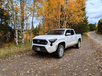
This was my first big drive in our new Tacoma. The last few miles to the trailhead were quite rough and muddy, so I was glad I had it instead of my old Impreza (RIP) or even our Outback.

Along Grassy Lake Road
I was the first to the trailhead, so I waited a bit and took a look around. This was the first I had heard of the Winegar Hole Wilderness

After everyone else showed up, we piled into Steve's truck and headed out toward the Pitchstone trailhead. It was a warm, sunny day, perfect conditions for the trail, which starts immediately into a decent climb to the top of the plateau. I didn't take any pictures on the way up. Too busy sweating.

Classic nonexistent trail up top.

Quick break to look at Phantom Fumarole
After a few hours, we reached camp. The spring was much lower than when we had been there a couple of years ago. No flow like last time, just still water. Fortunately, it was still more than enough.

The only water for who knows how far

Tetons in the distance at sunset

Hanging out (photo by Andrew)

Sunrise


We found this chewed? up tent partially shoved under a fallen log on the other side of the trees from where the fire ring and stuff was. Strange discovery. There was no other gear nearby.
We got going, and only after a little ways, it was time to head off trail. If I remember right, it was somewhere around 6 miles in a straight line to get across the plateau, then another 2 miles to get down to the trail along Gregg Fork. We were hoping to find remnants of the old trail from Gregg Fork up to the plateau to get us down the last 2 miles (thanks for documenting that a few years ago @scatman).

Steve, Dane, Nick

Skies were a little rainy, but we never dealt with more than a couple tiny sprinkles.

Really nice walking up there. Had a great time.
Not much sign of anything other than elk, deer, and rodents up there. I did find one old bear scat though.
We arrived at the edge of the plateau and had lunch in the woods. We had a waypoint for maybe where the trail would be, from a book Andrew has, but we could not find any traces of it. We followed a dry streambed for a little while as we made our way down. Eventually, we struck off on our own through the woods.


Old bear track

Nice walking.

We ended up in some marshy meadows down lower.

There was a lot of water running out of this hillside.

And there's Gregg Fork

At the very end, we found the old trail. Andrew and Steve are right above it here. There were logs down on it, and it was easier just not using it. I would be interested to see how far up you could follow it though, if it really would go all the way to the plateau.

Gregg Fork
It was a short walk to camp. After we were all set up, we took turns taking a dip in the creek to freshen up. It was cold.

Gregg Fork near camp
The next morning, we went for a soak.

Classic

Another classic. Had the place to ourselves somehow.

Usually it's cool and humid enough that you can hardly see the top of this feature. This day, it was dry and warm.
After a few hours, we got dressed and got back on our way.

Someone had thrown enough sticks down to connect to the log. It was precarious but saved some time.

Into the main canyon

We got to camp a little while later.

After we had set up, a law enforcement ranger rolled up to our site and checked our permit. Not a very chipper guy. He saw where we were headed for the next night and let us know there was a bear skull at the site and asked us to leave it alone and not remove teeth from it. He and his partner then went on their way up to the patrol cabin.
We had a nice evening around the fire. It was a little rainy in the morning.
The fun thing about the site we were at is that you have to ford the river immediately when you start the next day. Especially fun when it's cold in the morning. And then there's another ford shortly after that. We were headed to our next and final camp at the Fall River cutoff.

Almost across the second ford.

Shoes back on after the second ford.

Classic photo op

Iris Falls

Colonnade Falls. My pants got a good soaking from wet undergrowth on the spur trail to this one.

Lower down in the canyon
We took a little lunch break once we were out of the canyon. There's a camp site down there that I have almost never seen occupied, and it has made for a great stopping place on rainy days a few times now.
Back at it, along the Bechler in the meadow

The first, much smaller, dammed creek crossing

Some meadows

The big dammed (damned) crossing. Walking on top of the beaver dam was a little better than in other years. Much better than the mucky water where your feet sink 3-6" into the mud.
Only a litte farther along to camp. It started sprinkling on us again, and for the most part, it rained on us the rest of the evening.

Here's that bear skull the ranger told us not to touch. There weren't many teeth left to take anyway.
Andrew's rain tarp was very nice to have. We had dinner under it while it continued lightly raiing.

The crew sans Nick, who was taking a nice nap in the tent.

We got a fire going despite the rain, and the rain was light enough that you could mostly stay dry standing close to the fire.
Once it got dark, everyone was about ready for bed. It rained all night but let up right as it was time to get up. No worries packing out a wet tent since we only had a handful of miles back to the cars. We had to ford Mountain Ash Creek right when we started, since we were camped right next to it.

Really nice morning.

Then we had to cross the Fall River

Standing in the middle of the river.

Fish Lake, the sign that we were mostly done.
Back at the trailhead, we hung around for a bit and enjoyed the nice morning.

Another great Bechler area trip! This route ended up being a lot of fun with some new sights in the first part. We saw fewer people than normal on this one; maybe the rain kept them away. Can't recall speaking to more than maybe a group or two other than the ranger. I'm sure I'm forgetting details since I waited 6 months to write this though.
Lucky to be able to do these!
I took even longer than normal to write this up, somehow. Sitting here at the end of the Winter That Never Was (for the western, non-Alaska US, anyway) has me thinking about backpacking.
This was the 6th year in a row doing a trip in the Bechler area of Yellowstone. The group changes a little every time, but it's always a good time. The plan was to start at the Pitchstone Plateau, then head off trail to the upper reaches of the Bechler drainage, down the headwaters to the main river, and then out at Fish Lake off of Grassy Lake Road. Rec.gov would not let us book the campsites necessary for the route because it limits you based on trail miles between sites or something. A day of 35 or so trail miles from Pitchstone Pleateau to Gregg Fork seemed unfeasible to their system
So Andrew called the backcountry office a while after we had booked the trip to make a few modifications. We ended up getting all the sites we wanted.Everyone but me camped out along Grassy Lake Road the night before since we needed to leave a car or two at the ending trailhead for the shuttle. I got an early start a bit before sunrise.
Headed south on 191 toward Big Sky
I grabbed our permits in West Yellowstone and carried on.
This was my first big drive in our new Tacoma. The last few miles to the trailhead were quite rough and muddy, so I was glad I had it instead of my old Impreza (RIP) or even our Outback.
Along Grassy Lake Road
I was the first to the trailhead, so I waited a bit and took a look around. This was the first I had heard of the Winegar Hole Wilderness
After everyone else showed up, we piled into Steve's truck and headed out toward the Pitchstone trailhead. It was a warm, sunny day, perfect conditions for the trail, which starts immediately into a decent climb to the top of the plateau. I didn't take any pictures on the way up. Too busy sweating.
Classic nonexistent trail up top.
Quick break to look at Phantom Fumarole
After a few hours, we reached camp. The spring was much lower than when we had been there a couple of years ago. No flow like last time, just still water. Fortunately, it was still more than enough.
The only water for who knows how far
Tetons in the distance at sunset
Hanging out (photo by Andrew)
Sunrise
We found this chewed? up tent partially shoved under a fallen log on the other side of the trees from where the fire ring and stuff was. Strange discovery. There was no other gear nearby.
We got going, and only after a little ways, it was time to head off trail. If I remember right, it was somewhere around 6 miles in a straight line to get across the plateau, then another 2 miles to get down to the trail along Gregg Fork. We were hoping to find remnants of the old trail from Gregg Fork up to the plateau to get us down the last 2 miles (thanks for documenting that a few years ago @scatman).
Steve, Dane, Nick
Skies were a little rainy, but we never dealt with more than a couple tiny sprinkles.
Really nice walking up there. Had a great time.
Not much sign of anything other than elk, deer, and rodents up there. I did find one old bear scat though.
We arrived at the edge of the plateau and had lunch in the woods. We had a waypoint for maybe where the trail would be, from a book Andrew has, but we could not find any traces of it. We followed a dry streambed for a little while as we made our way down. Eventually, we struck off on our own through the woods.
Old bear track
Nice walking.
We ended up in some marshy meadows down lower.
There was a lot of water running out of this hillside.
And there's Gregg Fork
At the very end, we found the old trail. Andrew and Steve are right above it here. There were logs down on it, and it was easier just not using it. I would be interested to see how far up you could follow it though, if it really would go all the way to the plateau.
Gregg Fork
It was a short walk to camp. After we were all set up, we took turns taking a dip in the creek to freshen up. It was cold.
Gregg Fork near camp
The next morning, we went for a soak.
Classic
Another classic. Had the place to ourselves somehow.
Usually it's cool and humid enough that you can hardly see the top of this feature. This day, it was dry and warm.
After a few hours, we got dressed and got back on our way.
Someone had thrown enough sticks down to connect to the log. It was precarious but saved some time.
Into the main canyon
We got to camp a little while later.
After we had set up, a law enforcement ranger rolled up to our site and checked our permit. Not a very chipper guy. He saw where we were headed for the next night and let us know there was a bear skull at the site and asked us to leave it alone and not remove teeth from it. He and his partner then went on their way up to the patrol cabin.
We had a nice evening around the fire. It was a little rainy in the morning.
The fun thing about the site we were at is that you have to ford the river immediately when you start the next day. Especially fun when it's cold in the morning. And then there's another ford shortly after that. We were headed to our next and final camp at the Fall River cutoff.
Almost across the second ford.
Shoes back on after the second ford.
Classic photo op
Iris Falls
Colonnade Falls. My pants got a good soaking from wet undergrowth on the spur trail to this one.
Lower down in the canyon
We took a little lunch break once we were out of the canyon. There's a camp site down there that I have almost never seen occupied, and it has made for a great stopping place on rainy days a few times now.
Back at it, along the Bechler in the meadow
The first, much smaller, dammed creek crossing
Some meadows
The big dammed (damned) crossing. Walking on top of the beaver dam was a little better than in other years. Much better than the mucky water where your feet sink 3-6" into the mud.
Only a litte farther along to camp. It started sprinkling on us again, and for the most part, it rained on us the rest of the evening.
Here's that bear skull the ranger told us not to touch. There weren't many teeth left to take anyway.
Andrew's rain tarp was very nice to have. We had dinner under it while it continued lightly raiing.
The crew sans Nick, who was taking a nice nap in the tent.
We got a fire going despite the rain, and the rain was light enough that you could mostly stay dry standing close to the fire.
Once it got dark, everyone was about ready for bed. It rained all night but let up right as it was time to get up. No worries packing out a wet tent since we only had a handful of miles back to the cars. We had to ford Mountain Ash Creek right when we started, since we were camped right next to it.
Really nice morning.
Then we had to cross the Fall River
Standing in the middle of the river.
Fish Lake, the sign that we were mostly done.
Back at the trailhead, we hung around for a bit and enjoyed the nice morning.
Another great Bechler area trip! This route ended up being a lot of fun with some new sights in the first part. We saw fewer people than normal on this one; maybe the rain kept them away. Can't recall speaking to more than maybe a group or two other than the ranger. I'm sure I'm forgetting details since I waited 6 months to write this though.
Lucky to be able to do these!