Anyone with experience in Lower Grand Gulch?(Cedar Mesa/Bears Ears area of Utah)

Rybir

Member
Joined
Sep 13, 2024
Messages
7
First post ever here. I’m planning on 2 nights down in Lower Grand Gulch area. Specifically I have an interest in the Narrows area for the rock art. Does anyone have any suggestions or tips to provide?

I plan to carry all of my water in and keep the mileage a bit lower. I really just want to
visit the sites and be with them vs. big miles. I talked to the Kane Gulch BLM and got some water reports. Not much.

Thanks!
 
Lower Grand Gulch from which Trailhead.
 
From Collins TH, then into the Narrows. Or into the Narrows a bit, then up to Banister. I know Banister is more well travelled. But the Narrows is more of a mystery to me.
 
  • IMO, the side canyons are more interesting than Grand Gulch from a geologic perspective.
  • Not sure how far downcanyon you plan to go, but If you are planning on hiking to/near the San Juan River, there's a short boulder choked section of lower Grand Gulch that is very slow going and requires scrambling.
  • There's a nice camping spot down by the San Juan River, but it's also used by river rafters, and it's a little sketchy to get past the Grand Gulch landslide/pour-off.
 
I did the hike down from Collins a few years ago. Thought I filed a report but can't seem to find it. I went up as far as the Bannister Ruin, then went down to near Redman Canyon where I spent the night. Lots of great sites to see in that stretch, you'll love it! The next morning I poked around until I discovered an exit up on the north side of the Gulch. Then made my way to an old road that led back to the Collins parking lot...saved many hours of backtracking. I went in the Fall and don't remember there being any water or big holes where water would be retained for long...gulch was wide and flat.
 
Collins to Bannister.... a lot. Pretty much every alcove and rock nose has something. Cutoff loop by (west of) narrows has good stuff. Quite a bit from narrows to Redman Canyon which is the canyon on the west side (looking downstream) just past Water Canyon. Not a whole lot in Water Canyon. Not a ton till Shaw arch area, past that even less...mostly pictos/petros.

Remember that most sites (ruins) face southish. Pictos /petros can be anywhere... walls on canyon floor, above ledges. Best is to take binoculars to scan the cliff faces/ledges. More bush wacking you do to look at vertical areas the more you will find....
 
Hi @Rybir, I'd echo all the advice from @Bob, @napatony13, and @fossana ... that is a great part of the gulch to explore, since there are plenty of things to discover, and also because this section is a bit less brushy than some other areas, and many interesting sites can be spotted from walking along the wash.

On Day #1, you could set up camp close to the Narrows and then head east in the direction of Bannister, and then on Day #2, you could head south towards Water and Redman.

I hope you have a great trip !

p.s. I notice that the Kane Gulch Ranger Station is only open 4 days per week for the Fall season, due to staffing shortages, which is shame. After the establishment of the Bears Ears National Monument, I believe that there was some talk of this facility being expanded to become the official 'Visitor Center', so the current restricted hours seems a little surprising.
Hi there, so sick my first post on here is getting such respectful and useful input. Thank you!

It would be really nice to see Bannister Ruins. But our packs will be quite heavy with water. Maybe it’s a decent idea to go to Bannister with a day pack from camping near the entry to the Narrows?

Regarding the Narrows and Redman Canyon, does it open up a little down there to potentially find decent camping? I’m not looking for perfect campsites, but more so want to try and camp where others may before me. I want to reduce disruption of the environment as much as possible.
 
Collins to Bannister.... a lot. Pretty much every alcove and rock nose has something. Cutoff loop by (west of) narrows has good stuff. Quite a bit from narrows to Redman Canyon which is the canyon on the west side (looking downstream) just past Water Canyon. Not a whole lot in Water Canyon. Not a ton till Shaw arch area, past that even less...mostly pictos/petros.

Remember that most sites (ruins) face southish. Pictos /petros can be anywhere... walls on canyon floor, above ledges. Best is to take binoculars to scan the cliff faces/ledges. More bush wacking you do to look at vertical areas the more you will find....
From Narrows entry to Redman, can the “Big Panel” be found. And I don’t mean the Big Man panel. Thanks for the input.
 
Forgot ... You can go up Redman and put back to Collins TH. It's been a lot of years since I've been in the main canyon o i can't help with water much. I remember water in the narrows but it's easy to haul a bunch and cache it.
You can get on Google Earth and pick your spot
 
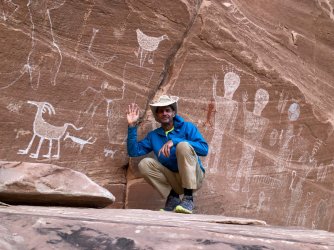
Regarding Bannister, it's nice but I found it a bit underwhelming as it's inaccessible and has to be viewed from below. Options would be to do it as a day hike if you arrive early or to stash packs near the Narrows before heading downcanyon. Once thru the Narrows the Gulch is wide and flat so finding a campsite shouldn't be a problem. I stayed on a brushy bench near Redman. Bob knows far more than me, but I looked for an exit from Redman and didn't see one, but did find my way out of the canyon just below it. Maybe my map is mislabeled, but I have my track saved and if you plan to go out that way I can send you a picture of my route. I think this photo is the Big Panel you asked about. If memory serves it was just a bit upstream from Water on right side of canyon. It's a bit away from the streambed and I walked right past it and had to backtrack to see it, but it's a good one.grand gulch.jpg
 
Regarding Bannister, it's nice but I found it a bit underwhelming as it's inaccessible and has to be viewed from below. Options would be to do it as a day hike if you arrive early or to stash packs near the Narrows before heading downcanyon. Once thru the Narrows the Gulch is wide and flat so finding a campsite shouldn't be a problem. I stayed on a brushy bench near Redman. Bob knows far more than me, but I looked for an exit from Redman and didn't see one, but did find my way out of the canyon just below it. Maybe my map is mislabeled, but I have my track saved and if you plan to go out that way I can send you a picture of my route. I think this photo is the Big Panel you asked about. If memory serves it was just a bit upstream from Water on right side of canyon. It's a bit away from the streambed and I walked right past it and had to backtrack to see it, but it's a good one.View attachment 135123
This is incredibly helpful thank you so much. It affirms our previously tentative plan of spending all of our time in the Narrows and lower Gulch. Thank you so much! And awesome picture.
 
NWS forecast for Blanding shows a good chance for rain over the next few days. If you're going to be in the Cedar Mesa canyons soon, there's a decent chance you'll have pothole water. You probably don't want to count on it, but something I would probably do in this situation is carry more days of food than water, and then opportunistically extend the trip if there happens to be water in there.
 
Regarding Bannister, it's nice but I found it a bit underwhelming as it's inaccessible and has to be viewed from below. Options would be to do it as a day hike if you arrive early or to stash packs near the Narrows before heading downcanyon. Once thru the Narrows the Gulch is wide and flat so finding a campsite shouldn't be a problem. I stayed on a brushy bench near Redman. Bob knows far more than me, but I looked for an exit from Redman and didn't see one, but did find my way out of the canyon just below it. Maybe my map is mislabeled, but I have my track saved and if you plan to go out that way I can send you a picture of my route. I think this photo is the Big Panel you asked about. If memory serves it was just a bit upstream from Water on right side of canyon. It's a bit away from the streambed and I walked right past it and had to backtrack to see it, but it's a good one.View attachment 135123
Been awhile but pretty sure Its in the cutoff canyon loop by the narrows.... Unfortunately it is also way chalked up
 
This is incredibly helpful thank you so much. It affirms our previously tentative plan of spending all of our time in the Narrows and lower Gulch. Thank you so much! And awesome picture.

This is incredibly helpful thank you so much. It affirms our previously tentative plan of spending all of our time in the Narrows and lower Gulch. Thank you so much! And awesome picture.
Referencing a comment below from someone else. But are the white pictographs ancient rock art or modern graffiti by someone?
 
NWS forecast for Blanding shows a good chance for rain over the next few days. If you're going to be in the Cedar Mesa canyons soon, there's a decent chance you'll have pothole water. You probably don't want to count on it, but something I would probably do in this situation is carry more days of food than water, and then opportunistically extend the trip if there happens to be water in there.
Thanks for looking out!
 
Been awhile but pretty sure Its in the cutoff canyon loop by the narrows.... Unfortunately it is also way chalked up
There are some nice ones in that loop, groups of figures holding hands if I remember correctly, but that's not where my picture was taken.
 
Back
Top