Any Beta in this Proposed Route Near Coffin Benchmark?

Perry

Formerly Cuberant
.
Joined
Aug 8, 2016
Messages
2,072
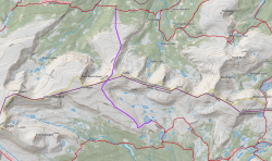
I'm investigating the feasibility of the route shown in purple between the Highline A Trail and Rainbow Lake? It's about 6.5 miles mostly above tree line, likely a ton rock walking. Anyone been across here?

81583
 
Last edited:
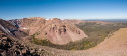
This totally doesn't answer the question since I haven't actually been there. However, judging from other parts of the same ridge farther east and west, I've found that the rocks aren't really too terrible below about 12,100 or 12,200 - there's enough grass to make travel reasonable. So were I in your shoes, I'd go for it. The tippy top will certainly be rocky, as well as the steeper slope facing east (I'd probably summit the top rather than skirt it, even though skirting would be more direct), but the fingers extending north and SE I would expect to be not terrible.

Really hoping you do this, as it's one of the most remote spots in the Uintas and nobody really goes up there. It's on "the list"!
I’m really tempted for sure. I like your suggestion of summiting the top. The east face might turn out to be no big deal once on site but that was my one concern of the route.
 
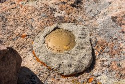
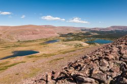
Weather was stellar but quite cold at night. Good thing I brought a down throw to put on top of my bag :) It was quite the crossing though.
 
Similar threads
Thread starter Title Forum Replies Date
JBG Water Beta 2022 - Highline Trail Trip Planning 6
Perry My First Multi-day Solo this Weekend - Looking for some Beta Trip Planning 0
Upgrayedd Sawtooths Beta needed Trip Planning 2
longtimesun Happy to provide beta on Mountains - New timer to BackCountry Post Noobs: Introduce yourself! 1
Devin Ashby Mount Agassiz Beta Trip Planning 4
Lisa Came for some trip beta, stayed for the great community... Noobs: Introduce yourself! 1
Bob Beta needed Grand Gulch area Trip Planning 6
IntrepidXJ Arches and Canyonlands National Parks Accepting Comments on Proposed Fee Increases for Backcountry Operations General Discussion 38
fossana Public comment period open until 10 Mar 2020 for proposed NEPA rollbacks General Discussion 4
Artemus Road Proposed to be Bulldozed through Red Cliffs Recreation Area General Discussion 7
Pianomover Trump administration Tuesday proposed allowing logging on more than half of Alaska’s 16.7 million-acre Tongass National Forest, the largest intact tem General Discussion 0
D New dams proposed for Little Colorado River/Grand Canyon General Discussion 2
Jmr Proposed National Park Fee Increase General Discussion 40
Nick Drilling proposed outside Zion National Park General Discussion 4
IntrepidXJ Proposed Day-Use Permits for Elephant Hill and White Rim Roads General Discussion 4
Bob Proposed Caldera National Monument ...... Idaho General Discussion 3
Kullaberg63 15 day canyon route Backpacking 13
fossana A challenging week on the Escalante Overland Route Backpacking 21
TheMountainRabbit Dana Meadows to Twin Lakes via the High Route (Yosemite/Hoover Wilderness) - August 2023 Backpacking 8
meowtaingal Wind river high route mid september Trip Planning 7
D Wind River offtrail route questions Trip Planning 28
scatman Grandeur Peak - Dragon Tail Route - June 10, 2023 Hiking & Camping 13
B Sawtooths - Off Trail Route Plan Trip Planning 9
TheMountainRabbit Red's Meadow to Tuolumne Meadows via the High Route (Ansel Adams/Yosemite Wilderness) - August 2022 Backpacking 5
climbhigh1119 How doable is the sneak route out of Death Hollow with kids and a dog? Trip Planning 6
PaulMags Grand - Moab Route Backpacking 1
seekinglost Introducing the Mojave-Sonoran Trail: A NEW 625-mile Winter Thru-Hiking Route Backpacking 4
RyanP Young's/Lean-To Route in DC Trip Planning 7
M Grand Canyon NP, Royal Arch Route Backpacking 0
Yvonne Climbing Mount Saint Helens via Monitor Ridge Route, July 2021 Hiking & Camping 16
scatman Grandeur Peak - Dagon's Tail Route - November 21, 2021 Hiking & Camping 9
RyanP Coyote Gulch to Halls Creek via Steven's Canyon and the Baker Route (car/key swap) Meet Up (Members Only) 8
stretch Most Scenic Route to Traverse the Gros Ventre? Trip Planning 17
W 9 Days Solo Escalante Loop in October (water advice) - Stevens Canyon, Baker Route over Waterpocket fold, Halls Narrows to Moody Canyons Trip Planning 11
M 5 days Green > Elk Wind River route advice August 17th Trip Planning 9
Mikjik86 FULL Video Part 2 Backpacking Glacier National Park "North Circle Route" Backpacking 0
Mikjik86 Backpacking Glacier National Park (Part 2 Preview) "North Circle Route" Montana, August 2019 Backpacking 2
Nick Dirty Devil Miner's Route Trip Planning 0
K Cycling The Divide Mountain Route Trip Planning 16
Mikjik86 Backpacking Glacier National Park - North Circle Route Part 1 Preview Video. Backpacking 1
b.stark Wrangell-St Elias "Seven Pass Route" Backpacking 29
Devin Ashby The Lower Gulch - Escalante (Seeking info on the route) Trip Planning 14
LarryBoy A Route In Between: Mexico to Canada Through the Heart of the West Backpacking 50
NorthwestWanderer Route Finding adventure, Copper Pass to Blue Lake - Goats, Bears, Lions, Oh my! Backpacking 3
Hiker Seth Thinking about this Wind River Route. Trip Planning 11
H Wind River Range route planning Trip Planning 6
NorthwestWanderer 6 Day backpacking trip in Glacier Peak Wilderness (3 days of off trail route) Backpacking 9
RyanP 5-day route in Winds in late July? Trip Planning 0
C Route 9 Through Zion closed indefinitely. General Discussion 25
DrNed Recommendation for 35-45 Mile Route in the Uintas Trip Planning 7

Similar threads

Back
Top