Archbishop
Make ready. Go forward!
- Joined
- Jan 21, 2012
- Messages
- 202
OK so I'm cheating a bit by posting this trip report. It's actually from October 2010, but in the interest of helping add some content to this site, and because I like to talk I figured I'd copy here for you all.
A few months ago at the end of October I took a trip out to Utah to visit Zion National Park. I saw several ghost towns, Camped out in a gully one night, met up with an internet acquaintance, Backpacked the ¾ the length of the National Park, and came face to face with a county sheriff with guns drawn all in weeks time. In short I had a blast.
It started several months before I decided I really wanted to take a trip and I wanted it be somewhere different from what I'm used to and I didn't want to break the bank. I was dying to go on another camping trip so everything seemed to match up perfectly. I had originally asked my neighbor to go with me, but he's a weeny so in the end I went solo. I'm not sure how I decided on Zion park, but once I settled on it I read everything I could find and planned my trip down to just about everything I could think about. (In the end I learned to be flexible, more on that later.)
I flew into Vegas on Tuesday morning. Rented a car and got out of Vegas as quick as possible. To each their own I suppose, but Vegas just sucks the life out of me. I stopped long enough go get supplies at the local wally world. Headed up through Nevada on the east side of area 51.
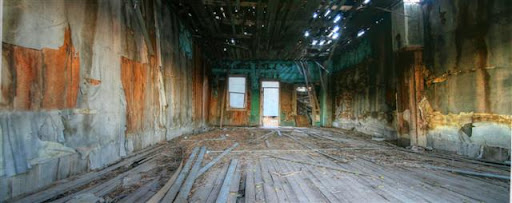
I stopped at two ghost towns during the afternoon. One was named Caliente and was pretty unremarkable, the Second was a town called Pioche. Pioche would be fairly boring to, save the local grave yard. I'd read online about an cemetery with markers from the wild west days. There was one in particular that I wanted to see if I could find. It's for a lady Named Virginia Marlotte. (I think I spelled her name right.) Her grave stone is reported to say, “Here lies Virginia Marlotte, born a virgin died a harlot. She protected her virginity for 18 years and that's pretty good for this damn town.”
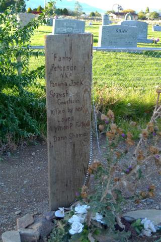
I never did find her grave stone but I did find several other grave marker that were interesting. One was of a women and at the bottom it said she was killed by her lover “damn shame”.
After the two ghost towns I was on my way into Nevada, but I stopped for just a bit at Cathedral Gorge state park. It was unique and interesting and would recommend it if you're in the area, but I probably wouldn't drive out of my way to see it.
Crossing over the Utah line by about 7-10 miles I came to another small ghost town called Modena. I decided to wait until morning to look around as the sun was already starting to set and I really needed to find my camp ground just outside of Modena.
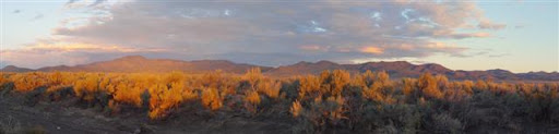
To set this up a bit let me describe the setting a bit. It's the desert and while there are mountains off in the distance, this area is flat and you can see for mile. All there is to see is sage brush, more sage brush, and the occasional trailer here or there 2-3 miles apart. I'd read about a camping site located just outside of Modena and figured it would be the perfect place to stop for the night. I had the GPS coordinates but the sun was setting fast.
I left the paved county road on to a local dirt road and looked at my GPS. It indicated the camp site about a mile and half north of my location. I took dirt road up and watched as my GPS indicated that the site was more to East of me now. So I took the first road to my right and kept going. The GPS quickly showed the campsite was straight to the north of me by about a third of a mile. The problem was there was not road. I thought about just cutting across the open ground. It was sandy dirt and sage brush. It didn't look like it would be problem but I decided against it as I was in a rental. I'm glad I made that choice. I later learned that there are little prickly plants in this area that will just “chew” your tires up if you drive across it.
I kept circling around the spot shown on GPS. The one lane dirt roads made a giant square with the campground in the middle. I was always about a 1/3 to a ½ mile away from the site. I was starting to get a bit desperate, there was nothing for miles save the one or two trailers that I could a few miles off. There was no alternative idea of where to stay for the night. The nearest real town was at least an hour away. I drove around the square lanes once or twice more hoping that I might have missed a smaller lane that would take me into the middle. I drove faster as the sun started circling.
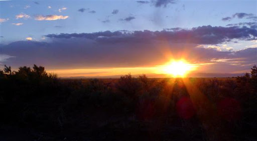
At one point on the dirt road it dipped down a few feet and cut across a dried gully. As I came to it for about the third time I got an idea I turned into the wash out and treated it like a road and drove towards the GPS mark. Unfortunately the gully didn't make it to the site so I made a quick decision to camp right where I was. I had no idea who's land I was on, but being a few feet down into a gully and the sage brush everywhere I was pretty invisible and there really wasn't anyone around so I figured it was a risk I was willing take.
I set up camp and started making my supper it was dark by this time and stars were absolutely beautiful. Off in the distance I noted a large truck coming in my general direction on the dirt road that ran right by the gully where I was hidden. I couldn't actually see the truck, but I could tell by the lights it was a larger truck or SUV. I flipped off my flashlight hoping he wouldn't see me as he drove by. (Remember I had no idea who's land I was on.) He drove slowly past my hiding spot, got about 30 feet up the road and stopped. I heard the door open and someone stepped out. I immediately tensed up. This was not good. I quietly took my gun out of my holster and waited as the person started walking my direction. Whoever it was, was moving slowly and had a flashlight pointed at the ground. I tucked down low at the base of gully to use it for cover I had my gun pointed down at the ground as I waited. The person was getting closer and my mind was just racing. This was not good. Who ever this was would be on me quickly and I had to decide quickly what I was going to do. Running didn't make sense but neither did pointing a gun at a stranger. I had no idea what the persons intentions were or who they were. For all I knew it was the land owner and I was in the wrong for trespassing. I used the most authoritative voice I could manage and ordered the person to identify themselves. I only had to wait a moment before the voice in the darkness quickly identified himself as the Deputy **** of the Iron Country Sheriffs department. I told him to relax that I was coming out to him. I holstered the weapon as I stood and came up and over the gully with my hands clearly in front of me.
The deputy had his shotgun in one hand and flashlight in the other. He asked me all the questions you'd expect. What was I doing here? Could he see some identification? Etc. Through it all he was very calm and polite. I told him honestly what was up. He verified my id and my cars info. He told me that one of the locals had seen me racing around in circles early as the sun was going down and thought that I might be ditching a stolen car. I could see how they might come to that conclusion. He told me no harm no foul. That he'd let the person know all was good and as far as he was concerned he didn't care if I spent the night. Went about as well as could be expecting considering we were just moments away from a Mexican stand off.
The next morning I took off for the final leg of my trip to Zion National Park. I checked into the rangers station, got my pass and parked my car at the trail head of LaVerkin Creek. LaVerkin trail is at the North west corner of the Kolob. It's a really nice, but remote section of the park. The main canyon is about a 30 to 40 minute car ride away so it doesn't see a lot of tourist. The weather was beautiful as I set off.
The first six miles of the hike was really pretty straightforward and easy. There were a few other people on thos trail. It was a pleasant hike with plenty to see as I gradually hiked down. If you're pessimist like me you can't shake the knowledge that if you're going down, you'll eventually have to go back up..... There's a small slot canyon at the top of the hike that I'd planned to go into, but I had a late start so I skipped it and hiked right in. I got to my campsite in good time. My first camp was right next to LaVerkin creek and had good cover from some very large pine trees. I got my camp set up and starting cooking dinner just as the storm clouds rolled in. I ate my fajitas and waited for the rain to start. The night was pretty uneventful. It did rain some, but really it was pretty mild. I got up the next morning and was surprised to find 4 wild turkey right in my campsite. Where's my shotgun when I need it. (Ya' I know, no hunting in the park. I'm just kidding.) I packed up and headed out. I took a quick detour to the Kolob Arch. It's pretty awesome to see as it's the second largest natural arch in the world. It's almost 300 feet across.
I got back on the main trail and crossed over LaVerkin Creek. Three guys crossed over the creek from the opposite direction right before I crossed. They would be the last guys I would see until towards the end of the day. Remember how I said the previous days hike was pretty much down hill? This part of the trail was the payback. It was a pretty steep hike up out of the Kolob. I crested over the top and immediately start down the hill into Hop Valley. Hop Valley was very pretty, but after a few miles of hiking through it I was just ready to get out. I also noticed that I wasn't moving as fast as I thought I would and was severely short on time. The logistics of the trail are such that this day was longest hiking day of the trip. I finally got through Hop valley and was just about ready to start the connector trail when I ran into a park ranger. I begged a ride and he was kind enough to take me up to the Wild Cat Canyon trail head. Effectively skipping the connector trail and thus shaving an hour or two off my hiking. I was really grateful as I was running out of time and wasn't really looking forward to hiking in the dark. I headed off down the trail and made pretty good time. The darkness was just setting in as I got to my campsite for the night.
The next morning, thinking about how I'd run out daylight the day before, I decided to get an earlier start. I packed up quickly and started off down the trail I finished up the last mile or so of the Wild cat and had just started on the top of the West Rim trail when it started sprinkling. I stopped long enough to put my jacket on and took off hiking into the rain. I passed a couple of hikers who were going the same direction, but I never saw them again. The rain never let up, but I was making good time. Such good time as a matter of fact that I made it to my designated campsite by 2 in the afternoon. I realized I had a decision to make. The rain hadn't let up and by this point I was pretty much soaked to the bone. I new my gear was probably wet to. Unlike my previous campsites this one was completely exposed on the ridgline and rain was making mini river right over the area to pitch a tent. I didn't relish the idea of sitting wet in a tent for the next several hours until bedtime with nothing to do, but I'd already hiked about 10 miles and was pretty spent. I looked at the campsite for another moment and decided screw it I would hike on and see how the other campsites looked.
I pushed on and did the next days hiking in the next several hours. All totaled I hiked about 18 miles that day. It never quit raining the entire time I was on the West Rim. I suppose it's just part of the adventure, but I feel gypped that didn't get to see any of the views through the fog. Toward the end of the hike as I came down of the rim into the main canyon I was literally telling myself, “left,right, left” in my mind concentrating hard on keeping my footing. My 35 pound pack weighed a ton.
I felt good as stepped into the main canyon I had made it a day ahead of schedule. About 42-43 miles in three days with my heavy backpack on. I am man hear me roar no matter how soaked I am. I did however, have a problem. I was suppose to meet a friend the following day when I got into the canyon,but I was day ahead of schedule and no way to reach my friend. It was too late to get a spot in the campsite in the main valley. I was effectively homeless.
I did the only thing I could think to do. I caught a bus into the nearby town and rented a room for the night. On the one hand it hurt my cheap heart to have to fork over money for the room on the other hand it gave opportunity to dry out my gear and get a good nights sleep. I managed to set off the smoke detector in my room cooking some rice and tuna.
The next day I caught up with my friend. Even though I'd only been in the back country for a few days it was still a jolt to go from the solitude of isolated trails onto the more heavily populated tourist trails. I spent the day doing some of the much shorter hikes in the main canyon. My buddy took me back up around to the top to get my rental car where I'd left it and we got in another hike up there.
He was gracious enough to show me where the free campsite is just outside of town. I camped there for the rest of my trip. Sure it was a bit of a drive each day, but free is free. Camping in the park was around 18 bucks a night I looked at as a way to recover some of my money from the one night in the hotel.
The last half the week was spent in the main part of the canyon doing the easy day hikes. It was nice to get around with my full backpack on. One morning my friend asked me about doing a hike out to observation point. It looks out over the North end of the main canyon and is over 1000 feet above the canyon floor. My friend Jon explained to me that the main path was around 3 miles or so and was more or less straight up Strenuous to say the least, but he knew a different way. If we drove around the outside of the park we could park up on the ridge and take a trail that wasn't widely known right out the same point on a relatively flat trail. I told him sounded like fun so we set off.
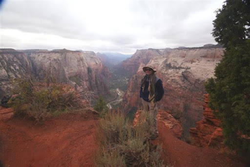
The drive up and around was pretty uneventful until the last half mile or so. The mud was so thick I worried my car would get stuck. I managed to get parked and we set off for the trail. The hike was nice and easy and had a few good views. We made it to Observation point and the view was incredible despite the overcast day. At least it wasn't raining. Being a tourist spot there were plenty of other people enjoying the view with us. Most people took pictures, ate snack meals, and in general just took it all in. Occasionally people would make small talk. One man told me that he could “really feel the hike in his legs” and wanted to know how I'd done on the hike. I told him I had no problem on the hike as I'd walked in on flat ground from where I'd parked my car. His look was priceless.
The next day I debated about doing Angel's Landing trail or the a bit of the Narrows trail. I really couldn't make up my mind. The trails are completely different from each other.
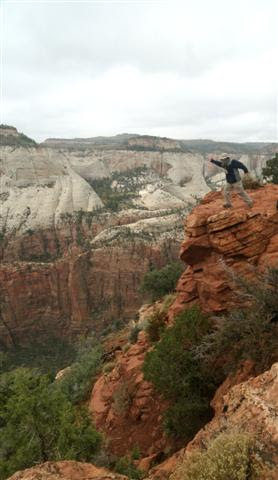
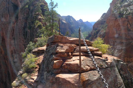
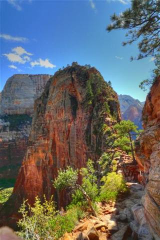
Angel's Landing takes you straight up out of the canyon and onto this narrow little ridge back that just out away from the main canyon wall like a knife. The last half mile of this hike is fairly steep and it's pretty much a straight drop off on the left and right. (A little over 1000 feet on average.) At it's narrowest point it's about 3 feet wide. You really have to be OK with heights to do this one. I wasn't sure if I was or not, but I knew I wanted to try it.
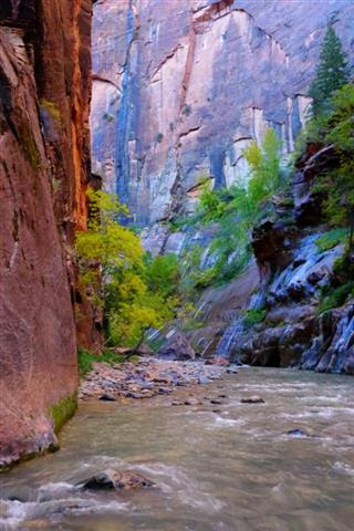
The Narrows is long hike through fairly narrow slot canyon. You pretty much have to hike in the Virgin river to do this hike and it's about 16 miles long. The walls of canyon at some places are well over 1000 feet tall and as it's name implies, the narrows is a very narrow trail. I knew I couldn't do the whole trail, but I wanted to do some of it.
My friend Jon encouraged me to do Angel's landing. His reasoning was that it was a nice sunny day and it shouldn't be wasted in some dark canyon. But he assured me I wouldn't go wrong with either hike. In the end I decided to try and squeeze both hikes in.
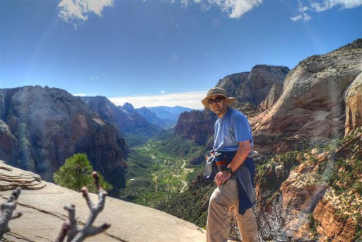
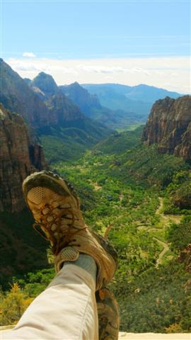
Angel's Landing is around 5 miles round trip and I knew I'd really have to hustle if I wanted to get to the Narrows afterwords. I kicked it up a notch and did Angel's landing in about 2 ½ hours. (Including the ½ hour I spent at the top taking in the view.)
When I came down off the trail I grabbed my water shoes and headed off for the Narrows. In order to get to this trail you have to walk the River Walk trail. I use the phrase “walk” not “hike” because really this trail is so easy it's hard to consider it a hike. It's very pretty though and I'm glad I got to see it. I wish I'd had more time to slow down and really take it in, but once again I was against the clock so to speak as the day was drawing to a close with so much more to do. I go to the Narrows put on my water shows and strolled into the river like I knew what I was doing. I wished that I'd taken a walking stick with me. Judging the depth of the water was tricky and was wanted to make sure I didn't loose my balance with my camera. I had a bag for it, but I didn't want to find out if it really was water proof or not. I only went up the Narrows a quarter mile or so, but the sights were incredible. If and when I get back to Zion Park I really want to spend more time in the Narrows.
All good things must come to an end. The following morning I packed up and left Zion park. I visited another ghost town on my way back to Vegas. It was pretty interesting, but really this post is already way to long. I got back to Vegas hopped a plane and headed back to Indy.
If you ever get a chance to visit Zion I highly recommend it. It was an adventure that I won't soon forget. I hope in another couple of years my boys will be old enough to go back with me and hike some of the trails with me.
A few months ago at the end of October I took a trip out to Utah to visit Zion National Park. I saw several ghost towns, Camped out in a gully one night, met up with an internet acquaintance, Backpacked the ¾ the length of the National Park, and came face to face with a county sheriff with guns drawn all in weeks time. In short I had a blast.
It started several months before I decided I really wanted to take a trip and I wanted it be somewhere different from what I'm used to and I didn't want to break the bank. I was dying to go on another camping trip so everything seemed to match up perfectly. I had originally asked my neighbor to go with me, but he's a weeny so in the end I went solo. I'm not sure how I decided on Zion park, but once I settled on it I read everything I could find and planned my trip down to just about everything I could think about. (In the end I learned to be flexible, more on that later.)
I flew into Vegas on Tuesday morning. Rented a car and got out of Vegas as quick as possible. To each their own I suppose, but Vegas just sucks the life out of me. I stopped long enough go get supplies at the local wally world. Headed up through Nevada on the east side of area 51.
I stopped at two ghost towns during the afternoon. One was named Caliente and was pretty unremarkable, the Second was a town called Pioche. Pioche would be fairly boring to, save the local grave yard. I'd read online about an cemetery with markers from the wild west days. There was one in particular that I wanted to see if I could find. It's for a lady Named Virginia Marlotte. (I think I spelled her name right.) Her grave stone is reported to say, “Here lies Virginia Marlotte, born a virgin died a harlot. She protected her virginity for 18 years and that's pretty good for this damn town.”
I never did find her grave stone but I did find several other grave marker that were interesting. One was of a women and at the bottom it said she was killed by her lover “damn shame”.
After the two ghost towns I was on my way into Nevada, but I stopped for just a bit at Cathedral Gorge state park. It was unique and interesting and would recommend it if you're in the area, but I probably wouldn't drive out of my way to see it.
Crossing over the Utah line by about 7-10 miles I came to another small ghost town called Modena. I decided to wait until morning to look around as the sun was already starting to set and I really needed to find my camp ground just outside of Modena.
To set this up a bit let me describe the setting a bit. It's the desert and while there are mountains off in the distance, this area is flat and you can see for mile. All there is to see is sage brush, more sage brush, and the occasional trailer here or there 2-3 miles apart. I'd read about a camping site located just outside of Modena and figured it would be the perfect place to stop for the night. I had the GPS coordinates but the sun was setting fast.
I left the paved county road on to a local dirt road and looked at my GPS. It indicated the camp site about a mile and half north of my location. I took dirt road up and watched as my GPS indicated that the site was more to East of me now. So I took the first road to my right and kept going. The GPS quickly showed the campsite was straight to the north of me by about a third of a mile. The problem was there was not road. I thought about just cutting across the open ground. It was sandy dirt and sage brush. It didn't look like it would be problem but I decided against it as I was in a rental. I'm glad I made that choice. I later learned that there are little prickly plants in this area that will just “chew” your tires up if you drive across it.
I kept circling around the spot shown on GPS. The one lane dirt roads made a giant square with the campground in the middle. I was always about a 1/3 to a ½ mile away from the site. I was starting to get a bit desperate, there was nothing for miles save the one or two trailers that I could a few miles off. There was no alternative idea of where to stay for the night. The nearest real town was at least an hour away. I drove around the square lanes once or twice more hoping that I might have missed a smaller lane that would take me into the middle. I drove faster as the sun started circling.
At one point on the dirt road it dipped down a few feet and cut across a dried gully. As I came to it for about the third time I got an idea I turned into the wash out and treated it like a road and drove towards the GPS mark. Unfortunately the gully didn't make it to the site so I made a quick decision to camp right where I was. I had no idea who's land I was on, but being a few feet down into a gully and the sage brush everywhere I was pretty invisible and there really wasn't anyone around so I figured it was a risk I was willing take.
I set up camp and started making my supper it was dark by this time and stars were absolutely beautiful. Off in the distance I noted a large truck coming in my general direction on the dirt road that ran right by the gully where I was hidden. I couldn't actually see the truck, but I could tell by the lights it was a larger truck or SUV. I flipped off my flashlight hoping he wouldn't see me as he drove by. (Remember I had no idea who's land I was on.) He drove slowly past my hiding spot, got about 30 feet up the road and stopped. I heard the door open and someone stepped out. I immediately tensed up. This was not good. I quietly took my gun out of my holster and waited as the person started walking my direction. Whoever it was, was moving slowly and had a flashlight pointed at the ground. I tucked down low at the base of gully to use it for cover I had my gun pointed down at the ground as I waited. The person was getting closer and my mind was just racing. This was not good. Who ever this was would be on me quickly and I had to decide quickly what I was going to do. Running didn't make sense but neither did pointing a gun at a stranger. I had no idea what the persons intentions were or who they were. For all I knew it was the land owner and I was in the wrong for trespassing. I used the most authoritative voice I could manage and ordered the person to identify themselves. I only had to wait a moment before the voice in the darkness quickly identified himself as the Deputy **** of the Iron Country Sheriffs department. I told him to relax that I was coming out to him. I holstered the weapon as I stood and came up and over the gully with my hands clearly in front of me.
The deputy had his shotgun in one hand and flashlight in the other. He asked me all the questions you'd expect. What was I doing here? Could he see some identification? Etc. Through it all he was very calm and polite. I told him honestly what was up. He verified my id and my cars info. He told me that one of the locals had seen me racing around in circles early as the sun was going down and thought that I might be ditching a stolen car. I could see how they might come to that conclusion. He told me no harm no foul. That he'd let the person know all was good and as far as he was concerned he didn't care if I spent the night. Went about as well as could be expecting considering we were just moments away from a Mexican stand off.
The next morning I took off for the final leg of my trip to Zion National Park. I checked into the rangers station, got my pass and parked my car at the trail head of LaVerkin Creek. LaVerkin trail is at the North west corner of the Kolob. It's a really nice, but remote section of the park. The main canyon is about a 30 to 40 minute car ride away so it doesn't see a lot of tourist. The weather was beautiful as I set off.
The first six miles of the hike was really pretty straightforward and easy. There were a few other people on thos trail. It was a pleasant hike with plenty to see as I gradually hiked down. If you're pessimist like me you can't shake the knowledge that if you're going down, you'll eventually have to go back up..... There's a small slot canyon at the top of the hike that I'd planned to go into, but I had a late start so I skipped it and hiked right in. I got to my campsite in good time. My first camp was right next to LaVerkin creek and had good cover from some very large pine trees. I got my camp set up and starting cooking dinner just as the storm clouds rolled in. I ate my fajitas and waited for the rain to start. The night was pretty uneventful. It did rain some, but really it was pretty mild. I got up the next morning and was surprised to find 4 wild turkey right in my campsite. Where's my shotgun when I need it. (Ya' I know, no hunting in the park. I'm just kidding.) I packed up and headed out. I took a quick detour to the Kolob Arch. It's pretty awesome to see as it's the second largest natural arch in the world. It's almost 300 feet across.
I got back on the main trail and crossed over LaVerkin Creek. Three guys crossed over the creek from the opposite direction right before I crossed. They would be the last guys I would see until towards the end of the day. Remember how I said the previous days hike was pretty much down hill? This part of the trail was the payback. It was a pretty steep hike up out of the Kolob. I crested over the top and immediately start down the hill into Hop Valley. Hop Valley was very pretty, but after a few miles of hiking through it I was just ready to get out. I also noticed that I wasn't moving as fast as I thought I would and was severely short on time. The logistics of the trail are such that this day was longest hiking day of the trip. I finally got through Hop valley and was just about ready to start the connector trail when I ran into a park ranger. I begged a ride and he was kind enough to take me up to the Wild Cat Canyon trail head. Effectively skipping the connector trail and thus shaving an hour or two off my hiking. I was really grateful as I was running out of time and wasn't really looking forward to hiking in the dark. I headed off down the trail and made pretty good time. The darkness was just setting in as I got to my campsite for the night.
The next morning, thinking about how I'd run out daylight the day before, I decided to get an earlier start. I packed up quickly and started off down the trail I finished up the last mile or so of the Wild cat and had just started on the top of the West Rim trail when it started sprinkling. I stopped long enough to put my jacket on and took off hiking into the rain. I passed a couple of hikers who were going the same direction, but I never saw them again. The rain never let up, but I was making good time. Such good time as a matter of fact that I made it to my designated campsite by 2 in the afternoon. I realized I had a decision to make. The rain hadn't let up and by this point I was pretty much soaked to the bone. I new my gear was probably wet to. Unlike my previous campsites this one was completely exposed on the ridgline and rain was making mini river right over the area to pitch a tent. I didn't relish the idea of sitting wet in a tent for the next several hours until bedtime with nothing to do, but I'd already hiked about 10 miles and was pretty spent. I looked at the campsite for another moment and decided screw it I would hike on and see how the other campsites looked.
I pushed on and did the next days hiking in the next several hours. All totaled I hiked about 18 miles that day. It never quit raining the entire time I was on the West Rim. I suppose it's just part of the adventure, but I feel gypped that didn't get to see any of the views through the fog. Toward the end of the hike as I came down of the rim into the main canyon I was literally telling myself, “left,right, left” in my mind concentrating hard on keeping my footing. My 35 pound pack weighed a ton.
I felt good as stepped into the main canyon I had made it a day ahead of schedule. About 42-43 miles in three days with my heavy backpack on. I am man hear me roar no matter how soaked I am. I did however, have a problem. I was suppose to meet a friend the following day when I got into the canyon,but I was day ahead of schedule and no way to reach my friend. It was too late to get a spot in the campsite in the main valley. I was effectively homeless.
I did the only thing I could think to do. I caught a bus into the nearby town and rented a room for the night. On the one hand it hurt my cheap heart to have to fork over money for the room on the other hand it gave opportunity to dry out my gear and get a good nights sleep. I managed to set off the smoke detector in my room cooking some rice and tuna.
The next day I caught up with my friend. Even though I'd only been in the back country for a few days it was still a jolt to go from the solitude of isolated trails onto the more heavily populated tourist trails. I spent the day doing some of the much shorter hikes in the main canyon. My buddy took me back up around to the top to get my rental car where I'd left it and we got in another hike up there.
He was gracious enough to show me where the free campsite is just outside of town. I camped there for the rest of my trip. Sure it was a bit of a drive each day, but free is free. Camping in the park was around 18 bucks a night I looked at as a way to recover some of my money from the one night in the hotel.
The last half the week was spent in the main part of the canyon doing the easy day hikes. It was nice to get around with my full backpack on. One morning my friend asked me about doing a hike out to observation point. It looks out over the North end of the main canyon and is over 1000 feet above the canyon floor. My friend Jon explained to me that the main path was around 3 miles or so and was more or less straight up Strenuous to say the least, but he knew a different way. If we drove around the outside of the park we could park up on the ridge and take a trail that wasn't widely known right out the same point on a relatively flat trail. I told him sounded like fun so we set off.
The drive up and around was pretty uneventful until the last half mile or so. The mud was so thick I worried my car would get stuck. I managed to get parked and we set off for the trail. The hike was nice and easy and had a few good views. We made it to Observation point and the view was incredible despite the overcast day. At least it wasn't raining. Being a tourist spot there were plenty of other people enjoying the view with us. Most people took pictures, ate snack meals, and in general just took it all in. Occasionally people would make small talk. One man told me that he could “really feel the hike in his legs” and wanted to know how I'd done on the hike. I told him I had no problem on the hike as I'd walked in on flat ground from where I'd parked my car. His look was priceless.
The next day I debated about doing Angel's Landing trail or the a bit of the Narrows trail. I really couldn't make up my mind. The trails are completely different from each other.
Angel's Landing takes you straight up out of the canyon and onto this narrow little ridge back that just out away from the main canyon wall like a knife. The last half mile of this hike is fairly steep and it's pretty much a straight drop off on the left and right. (A little over 1000 feet on average.) At it's narrowest point it's about 3 feet wide. You really have to be OK with heights to do this one. I wasn't sure if I was or not, but I knew I wanted to try it.
The Narrows is long hike through fairly narrow slot canyon. You pretty much have to hike in the Virgin river to do this hike and it's about 16 miles long. The walls of canyon at some places are well over 1000 feet tall and as it's name implies, the narrows is a very narrow trail. I knew I couldn't do the whole trail, but I wanted to do some of it.
My friend Jon encouraged me to do Angel's landing. His reasoning was that it was a nice sunny day and it shouldn't be wasted in some dark canyon. But he assured me I wouldn't go wrong with either hike. In the end I decided to try and squeeze both hikes in.
Angel's Landing is around 5 miles round trip and I knew I'd really have to hustle if I wanted to get to the Narrows afterwords. I kicked it up a notch and did Angel's landing in about 2 ½ hours. (Including the ½ hour I spent at the top taking in the view.)
When I came down off the trail I grabbed my water shoes and headed off for the Narrows. In order to get to this trail you have to walk the River Walk trail. I use the phrase “walk” not “hike” because really this trail is so easy it's hard to consider it a hike. It's very pretty though and I'm glad I got to see it. I wish I'd had more time to slow down and really take it in, but once again I was against the clock so to speak as the day was drawing to a close with so much more to do. I go to the Narrows put on my water shows and strolled into the river like I knew what I was doing. I wished that I'd taken a walking stick with me. Judging the depth of the water was tricky and was wanted to make sure I didn't loose my balance with my camera. I had a bag for it, but I didn't want to find out if it really was water proof or not. I only went up the Narrows a quarter mile or so, but the sights were incredible. If and when I get back to Zion Park I really want to spend more time in the Narrows.
All good things must come to an end. The following morning I packed up and left Zion park. I visited another ghost town on my way back to Vegas. It was pretty interesting, but really this post is already way to long. I got back to Vegas hopped a plane and headed back to Indy.
If you ever get a chance to visit Zion I highly recommend it. It was an adventure that I won't soon forget. I hope in another couple of years my boys will be old enough to go back with me and hike some of the trails with me.
Taken in Modena UT
This is the grave marker I was talking about.
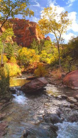
This was the morning view from the "gully wash" where I met the County Sheriff.
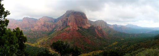
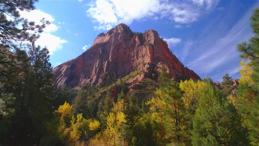
View from the bottom of the Kolob
From the top of the Kolob.
The Second longest arch in the world. 287 feet wide.
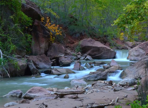
LaVerkin creek
This was the view across the creek from my first campsite.
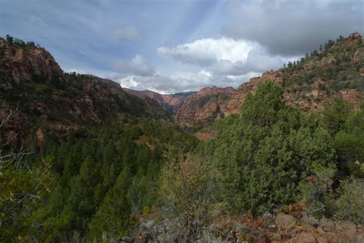
Hop Valley
Wild Cat Canyon Trail
Me at Observation point.
Taking the leap of faith?
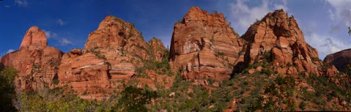
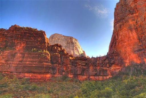
The Great White Thrown as seen over the rock formation known as The Organ.
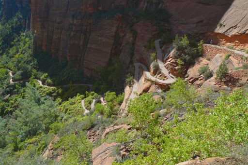
This is the path up to Angel's Landing.
This rock is known as the "step of faith." It's the narrowest point in the trail of Angel's Landing.
Final push for Angel's Landing
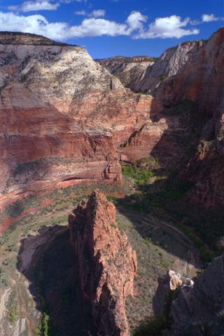
The view from the top of Angel's Landing.
View from the other direction.
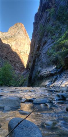
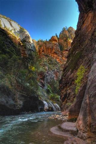
Virgin River on the River Walk Trail.
The start of the Narrows.
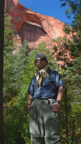
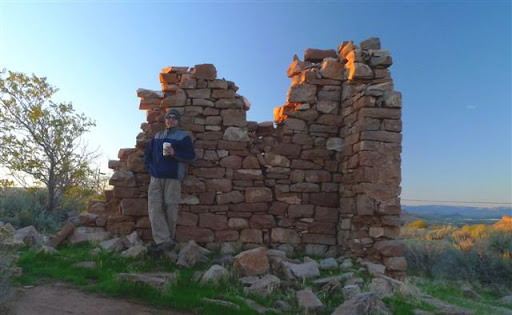
Me next to the some ruins in Silver Reef UT