Born to Hike
Member
- Joined
- Jan 14, 2017
- Messages
- 146
This trip was a week of discovery on this 85+ mile solo through hike:
I can do a 7 day trip with my 65 L pack.
Why there is not a complete Uinta High-route.
It is a challenge to keep up with the Calories.
The bigger lakes do not always have the bigger fish..different story with the smaller obscure lakes.
Crater Lake.
I found an Elasomosaurus Dinosaur!
This trip was planned over seven months ago, not fully believing it would happen. But the sun, moon and stars all seemed to line up for me to go..but even during the 6 hour drive to Chapeta Lake it was hard to believe it was actually happening: a through hike from East to West in the High Uintas, solo, 80 + miles in 7 days.
A good climb driving to Chapeta Lake

Beautiful stands of Aspens on the drive up

My Angel wife dropping me off at the Trailhead. It was close to a 6 hour drive to get there. She would pick me up 6 days later at the Highline TH by Mirror Lake -only a 2.5 hour drive away.

Chapeta Lake, 5pm, July 26 2020. A beautiful evening with no storms threatening, I decided a nice Sunday stroll for a couple of hours into the sunset would be nice - with my pack on of course!

It was a beautiful Sunday evening.

Small Lake en route

Meadows opening up

Starting the climb, looking back from where I began

Up into the sunset and sky

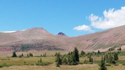
1st glimpse of Queant Lake with that interesting square shaped flat top further South

Taylor Lake. I would camp above the Lake not to far from here

Selfie above Taylor Lake.

I setup camp and hiked down to Taylor Lake for water and the scenery. Fish were rising..should have brought my pole to the Lake too.

Nice to have the views that first night.


Ok, I was not going completely solo.. 2 of my loyal dogs came along. Diesel making his way Monday morning towards North Pole Pass.

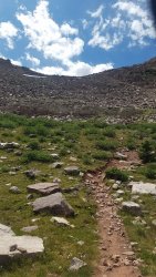
Well marked route above treeline and towards the High Route.

Snowfields

Wide open Blue Sky


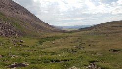
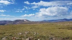
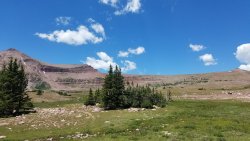
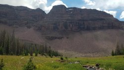
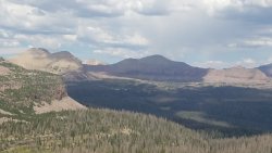
The high route is theoretically to go around this basin shown on the right of this photo on the mountain tops and ridges and off trail - the planned route for the day.

So I veered right (North) past North Pole Pass and continued to climb. Spring on top at 12,200 + feet.

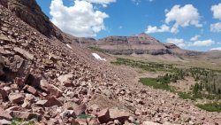
Looking back (East) from where I came. A lot of maneuvering through large "scree" and boulders - it was slow going even on the flat.


At this point the only route was back down-hill towards Divide Lake, then up again negotiating through the same type of scree and boulders. I was quickly losing interest continuing this High Route, especially carrying a 40 + pound pack. No wonder others do not go on this section of the "High Route" - extremely difficult and slow to do with little reward.

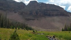
Divide Lake: no more High Route for me - had other other places to go and see. At Divide had a quick lunch and made my way to Fox Lake.

Fox Lake looking back up towards North Pole Pass, where I continued left along the High Route.

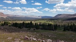
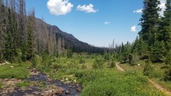
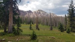
For the next 5 hours I boogied past Kidney Lakes and later Milk Lake towards Painter Basin - my next goal was to summit King's Peak the next day and pounded the miles to get as close to Anderson Pass before setting up camp..I was already spoiled by the wide open expanse and this part of the route was mostly through trees.
The first view of Painter Basin with a storm settling in.

Painter Basin in the rain. It was 7 pm, closing out a 18 mile day. Not the most fun setting up camp in the rain, but very grateful for a dry tent and sleeping bag and very nice falling asleep to the sound of
") rain - apparently quite the storm all night long.
rain - apparently quite the storm all night long.

Packed and ready to go the next morning to Anderson Pass and bag King's Peak: was happy that my 65 L Alta Backpack (one of the most comfortable packs ever made) was enough for this 7 day trip. Strapped on the sides of my pack is my tent and the dog's sleeping pad.

Looking back towards Painter Basin while ascending towards Anderson Pass.

The weather might change my plans..

Close to Anderson Pass I stopped to resupply my water. I thought this would be the last water source..but discovered..

.. a spring at Anderson Pass. Straight ahead is the no-name "pass" that drops directly down into the Henry's Fork area.

There were many people descending King's Peak trying to avoid the weather coming in.
Hikers descending Anderson Pass.

Nears Anderson Pass looking North East The dots are people leaving the area towards Gunsight Pass.

Walls of hail were coming down around me, but there was no threat of thunder or lightning of any kind, so I decided to go for King's Peak.

Hail came and went falling mostly UP and SIDEWAYS from the West smacking me in the face..I wish I took a video of that..

Another crazy thing that happened during the climb to King's was a male hummingbird flying to us in the hailstorm checking us out (this was at 13,000 feet), then flying off as quickly as it came.

Made it! Notice the storm was gone..

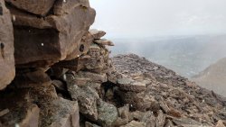
Proof I bagged King's Peak.

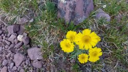
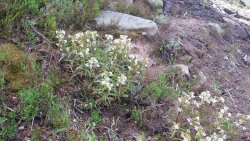
Patch of yellow beauties as Anderson Pass.

Another hailstorm came down while descending Anderson Pass..too tired and out of calories from the last two days of hiking to take more photos I setup camp and watched the sunset light-up Kings and South Kings Peaks before going to bed.

Morning view of Mount Powell from where I camped the night before. There are some small lakes up there I would like to fish sometime.

Looking back at Tungsten Lake while climbing towards Porcupine Pass.

The climb to the base of Porcupine pass was a lovely one: lakes on the left..

..and lakes on the right.

Close to the top of Porcupine Pass.

At the top of Porcupine Pass looking back where I came from..

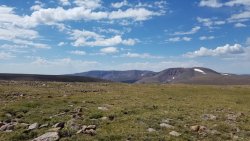
..and looking forward to where I was going: Oweep Basin.

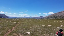
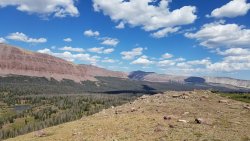
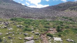
I've wanted to visit this basin the moment I learned about it: incredibly vast and open at over 11,000 feet in elevation.

Good spot for lunch.

The West side of Porcupine Pass as a backdrop while I had lunch. There IS a trail coming off of that.

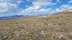
After lunch started the grand tour of Oweep, passing Squaw Pass on the right (North).

I think the taller peak showing over the closer mountain range is Tokevanna Peak (?) to the North.

How I filter and carry water on the go: A Sawyer Squeeze that quick-connects directly into the water bladder in my pack. I normally use a Cnoc bag that connects to the Sawyer, but the bag failed 2 days into this trip.

Looking back on the upper portion of Oweep Basin in the background as I climb higher towards Lambert Lake.

I decided to go off trail towards Lambert..this is the first Lake I came to, thinking it was Lambert lake..

Good enough for a place to camp..and then realized I was East of Lambert by about 1/3 of a mile, so headed cross country to Lambert and..

walked out to see a guy here (small body of water next to Lambert) in the buff just coming out of the water haha! His back was towards me and did not notice me come out of the trees so I quickly and quietly went around the opposite side to check out Lambert Lake..

Lake Lake - super crowded for what I have been used to the past three days. There were around 15 people camping here - so I turned back and headed to the original little bit of paradise I found just 1/3 of a mile to the East..


This will do just fine for the night: The evening was warm (for the Uintas) and clear and after 3 days of hiking I could'nt help myself to get in this little lake and clean clothes and body off.

Fortunately the cleaning was not too toxic to kill the fish that were in there..
Diesel inspecting a catch: This little lake was a hot spot to fish - good sized and almost every cast: maybe they just wanted to get out of the water after I was in it haha!

The next day heading up towards Red Knob Pass

Red Knob Pass (to the left). Curious about Crater Lake that is just a few miles from here, I headed left around the upper portion of this basin towards Crater Lake.

Information about Crater Lake is hard to find - even though it is the deepest lake in the Uintas. Some stories about this lake are crazy too, which peaked my interest and desire to go visit the Lake itself. Not know the best route to take, I simply headed around the upper portion of the basin below Red Knob Pass towards the lake.
Crater Lake is on the other side of the flat-top mountain in the foreground: a little foreboding of how to get there, which makes sense why many do not make the effort to visit the Lake while passing by on the Highline Trail.

Greeeaaat..a boulder field to pass through on the way to Crater Lake

It is slow and tedious going through a boulder field like this one, with packs on..
Looking back from the boulder hopping: the dogs did amazingly well following the route I chose through that freaking boulder field - only had to help them once.

Coming to this was a relief, still some boulders to negotiate..

Following the Crater Lake drainage

Up, up you go..

First you see Explorer Peak

Looking back towards Red Knob Pass

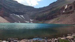
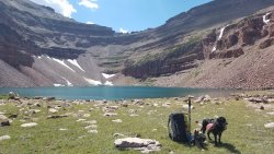
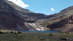
Suddenly Crater Lake appears: It was incredible to climb instantly into this upper basin. Beautiful. Breathtaking. Worth the effort and climb to get there.


Crater Lake: I'll stay for the night.


Crater Lake. Hard to find many photos of this Lake and Basin, so here ya go..


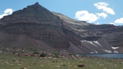
Standing at the South Rim bordering Crater Lake looking South, assuming the best route to come and leave this Lake is from this direction.

Explorer Peak above Crater Lake.

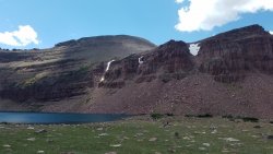
Looking Northwest from the rim surrounding Crater Lake Basin

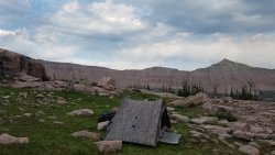
My tent was so happy to be there it was floating in the air!

There is a small rise East of Crater Lake, forming the basin.

After setting up my tent I had to try the fishing: it was ok but not that great - no big ones interested. The soft grass next to the lake was inviting too.


I could hear the sheep herders below, yelling and whistling as they came up the lower Lambert Meadow basin. I still felt pretty isolated until I saw one of the sheepherders ride up to the Lake on horseback, saw me and left! That made sense for the lack of good fishing in this Lake. Disappointed, I walked over to see where he came up and found a faint trail on the South side coming up to the Lake - the route to find and use getting to Crater Lake, not the northern boulder route.

More views from the rim of the Crater Lake Basin.
Sunset over Red Knob Pass.

Lambert Meadow and Oweep Basin drainage.

Another pic of Explorer Peak.

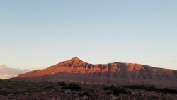
Sunset on Mount Lovenia

Last light on Explorer Peak above Crater Lake. A calm, beautiful evening and night.

Good Morning Crater Lake.

I left this beatiful spot following the faint trail South of the Lake - it led all the way to the lower basin.
My finger pointing to the faint trail leading up to Crater Lake - it is South of the Lake.

Hiking to Red Knob Pass was following several sheep trails, and through several sheep..

The walk from Crater Lake to the top of Red Knob Pass took about 1.5 hours: not to bad I thought..
Red Knob Pass looking North.

Red Knob pass looking West towards Dead Horse Lake.

Red Knob Pass looking South towards Crater Lake - you can see Crater Lake in the distance: 1.5 hour walk from there to here.

Looking Southeast.

I really enjoyed Red Knob Pass: definitely my favorite mountain Pass on this trip. The views here reminded me of the Windriver Range.


Beginning the descent to the North slope of the Uintas. Will only spend a few hours on the North slope on the trip..


Meadows and wildflowers


..and more wildflowers


The amount of wildflowers on the North slope compared to the South Slope was amazing and beautiful to hike through towards Deadhorse Pass.

Deadhorse Lake. Time for lunch and some rest before mountain pass #2 - Deadhorse Pass.

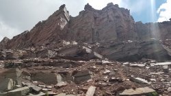
I love looking at the Geology of the mountains - the climb up Deadhorse Pass was no exception

The views open up quickly ascending Deadhorse Pass..

More fascinating geology close to the top of the Pass.

Deadhorse Pass looking down into Rock Creek Basin. Just over the middle ridge is Crater Lake where I stayed the night before - less than 2 miles away - if your an Eagle that is.

oh the Geology..and history of this place..

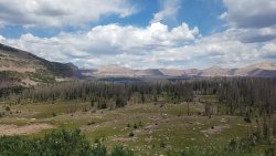
West Fork of the Blacks Fork, Ejod Lake, Deadhorse Lake.


Upper Rock Creek Basin and drainage. Continent Lake is just to the right out the picture - my next stop that day.

Continent Lake. I was here last year, but without a fishing pole, and regretted it as I saw the fish swimming around in the clear water.

I have been passing these guys back and forth the whole trip - taking close to the same route as mine. Looks like their bringing home dinner from Continent Lake.

Continent Lake and Deadhorse Pass in the background. I redeemed myself and fished for an hour or so. Tired from the climbing two passes and the hike in general that day I started to look for a good spot to camp.

Remembering an area above Ledge Lake from last year I went looking for it..

This spot will do


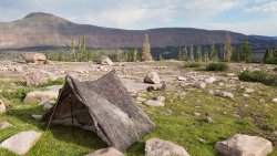
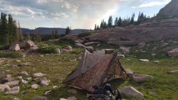
It is worth looking for epic places to setup my tent and enjoy the views around me - especially on a trip like this one.


Fresh smoke from a forest fire to the West beyond Rocky Sea Pass.

This would be the last night on this Trip: I was in familiar territory now and started to think about a double cheese burger I could get to the next day. But one more look at the sunset..

It would not be a fulfilling scenic trip without taking the "high route" of Rock Creek Basin..

Helen Lake. Just on the other side of this ridge is Amethyst Lake on the North Slope of the range.

More high meadows and wildflowers. Not as abundant as the North Slope of the range, but still very nice..


Glady's Lake. Numerous fish rising to the surface here.

Brinkley Lake. The last lake before climbing Rocky Sea Pass.

Seriously after a full week of hiking and six mountain passes, this one looked easy to do. Plus my pack was much lighter too.

East side of Rocky Sea Pass.


The forest fire West of Rocky Sea Pass and Mirror Lake. Mount Timpanogos in the background. From here I could call my wife and let her know she could soon leave to come and pick me up at the Highline TH.

Taking a break at Pigeon Milk Spring. The water here tastes sooo good - unfiltered! Only 7+ miles to go..it has been a 12 mile day so far. Will be an almost 20 mile day. Those cheeseburgers are worth it. Plus I wanted the next day, Sunday to be a good rest day at home before the real world set in again.

I earned this scrub, and am definitely thinner around the face and waistline. You burn so many calories doing a hike like this and it is difficult to keep up. That double cheeseburger is waiting for me..
Modeling my new hat.

The burn area around Scudder Lake. Signs of new life two years after a fire came through..


It was a hot fire and burned the soil and wonder if pines will grow here anytime soon..my guess is an eventual open meadow down to and around Scudder Lake will replace the burn.

My sweet wonderful wife waiting to take me home - after the double cheese burger naturally..

..but wait there is more to this trip..
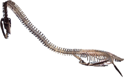
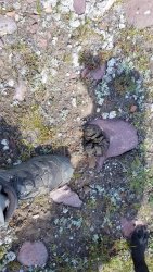
One evening I was eating my freeze-dried dinner when I realized I was looking at a Dinosaur fossil!


You can actually count the vertebre running along the top.


The size of it compared to my full sized black lab. I stepped it off to be about 18' long.
Turns out the head is on the left of the photo with the tail going past where Diesel is standing, which means the actual animal size was closer to 30' long!

Apparently it was one of these (I'm not a paleontologist, so this is my best guess) : a juvenile Elasomosarus Dinosaur! How cool is that? It lived and died here where the High Uintas now stand (current elevation over 11,000 feet) about 100 million years ago. Wow!
A fun way to end the report of an EPIC trip! It was life changing and I'm very glad I did it: Solo, in the High Uintas.

I can do a 7 day trip with my 65 L pack.
Why there is not a complete Uinta High-route.
It is a challenge to keep up with the Calories.
The bigger lakes do not always have the bigger fish..different story with the smaller obscure lakes.
Crater Lake.
I found an Elasomosaurus Dinosaur!
This trip was planned over seven months ago, not fully believing it would happen. But the sun, moon and stars all seemed to line up for me to go..but even during the 6 hour drive to Chapeta Lake it was hard to believe it was actually happening: a through hike from East to West in the High Uintas, solo, 80 + miles in 7 days.
A good climb driving to Chapeta Lake
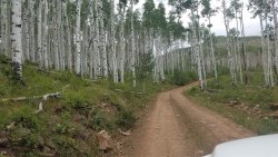
Beautiful stands of Aspens on the drive up
My Angel wife dropping me off at the Trailhead. It was close to a 6 hour drive to get there. She would pick me up 6 days later at the Highline TH by Mirror Lake -only a 2.5 hour drive away.
Chapeta Lake, 5pm, July 26 2020. A beautiful evening with no storms threatening, I decided a nice Sunday stroll for a couple of hours into the sunset would be nice - with my pack on of course!
It was a beautiful Sunday evening.
Small Lake en route
Meadows opening up
Starting the climb, looking back from where I began
Up into the sunset and sky
1st glimpse of Queant Lake with that interesting square shaped flat top further South
Taylor Lake. I would camp above the Lake not to far from here
Selfie above Taylor Lake.
I setup camp and hiked down to Taylor Lake for water and the scenery. Fish were rising..should have brought my pole to the Lake too.
Nice to have the views that first night.
Ok, I was not going completely solo.. 2 of my loyal dogs came along. Diesel making his way Monday morning towards North Pole Pass.
Well marked route above treeline and towards the High Route.
Snowfields
Wide open Blue Sky
The high route is theoretically to go around this basin shown on the right of this photo on the mountain tops and ridges and off trail - the planned route for the day.
So I veered right (North) past North Pole Pass and continued to climb. Spring on top at 12,200 + feet.
Looking back (East) from where I came. A lot of maneuvering through large "scree" and boulders - it was slow going even on the flat.
At this point the only route was back down-hill towards Divide Lake, then up again negotiating through the same type of scree and boulders. I was quickly losing interest continuing this High Route, especially carrying a 40 + pound pack. No wonder others do not go on this section of the "High Route" - extremely difficult and slow to do with little reward.
Divide Lake: no more High Route for me - had other other places to go and see. At Divide had a quick lunch and made my way to Fox Lake.
Fox Lake looking back up towards North Pole Pass, where I continued left along the High Route.
For the next 5 hours I boogied past Kidney Lakes and later Milk Lake towards Painter Basin - my next goal was to summit King's Peak the next day and pounded the miles to get as close to Anderson Pass before setting up camp..I was already spoiled by the wide open expanse and this part of the route was mostly through trees.
The first view of Painter Basin with a storm settling in.
Painter Basin in the rain. It was 7 pm, closing out a 18 mile day. Not the most fun setting up camp in the rain, but very grateful for a dry tent and sleeping bag and very nice falling asleep to the sound of
rain - apparently quite the storm all night long.Packed and ready to go the next morning to Anderson Pass and bag King's Peak: was happy that my 65 L Alta Backpack (one of the most comfortable packs ever made) was enough for this 7 day trip. Strapped on the sides of my pack is my tent and the dog's sleeping pad.
Looking back towards Painter Basin while ascending towards Anderson Pass.
The weather might change my plans..
Close to Anderson Pass I stopped to resupply my water. I thought this would be the last water source..but discovered..
.. a spring at Anderson Pass. Straight ahead is the no-name "pass" that drops directly down into the Henry's Fork area.
There were many people descending King's Peak trying to avoid the weather coming in.
Hikers descending Anderson Pass.
Nears Anderson Pass looking North East The dots are people leaving the area towards Gunsight Pass.
Walls of hail were coming down around me, but there was no threat of thunder or lightning of any kind, so I decided to go for King's Peak.
Hail came and went falling mostly UP and SIDEWAYS from the West smacking me in the face..I wish I took a video of that..
Another crazy thing that happened during the climb to King's was a male hummingbird flying to us in the hailstorm checking us out (this was at 13,000 feet), then flying off as quickly as it came.
Made it! Notice the storm was gone..
Proof I bagged King's Peak.
Patch of yellow beauties as Anderson Pass.
Another hailstorm came down while descending Anderson Pass..too tired and out of calories from the last two days of hiking to take more photos I setup camp and watched the sunset light-up Kings and South Kings Peaks before going to bed.
Morning view of Mount Powell from where I camped the night before. There are some small lakes up there I would like to fish sometime.
Looking back at Tungsten Lake while climbing towards Porcupine Pass.
The climb to the base of Porcupine pass was a lovely one: lakes on the left..
..and lakes on the right.
Close to the top of Porcupine Pass.
At the top of Porcupine Pass looking back where I came from..
..and looking forward to where I was going: Oweep Basin.
I've wanted to visit this basin the moment I learned about it: incredibly vast and open at over 11,000 feet in elevation.
Good spot for lunch.
The West side of Porcupine Pass as a backdrop while I had lunch. There IS a trail coming off of that.
After lunch started the grand tour of Oweep, passing Squaw Pass on the right (North).
I think the taller peak showing over the closer mountain range is Tokevanna Peak (?) to the North.
How I filter and carry water on the go: A Sawyer Squeeze that quick-connects directly into the water bladder in my pack. I normally use a Cnoc bag that connects to the Sawyer, but the bag failed 2 days into this trip.
Looking back on the upper portion of Oweep Basin in the background as I climb higher towards Lambert Lake.
I decided to go off trail towards Lambert..this is the first Lake I came to, thinking it was Lambert lake..
Good enough for a place to camp..and then realized I was East of Lambert by about 1/3 of a mile, so headed cross country to Lambert and..
walked out to see a guy here (small body of water next to Lambert) in the buff just coming out of the water haha! His back was towards me and did not notice me come out of the trees so I quickly and quietly went around the opposite side to check out Lambert Lake..
Lake Lake - super crowded for what I have been used to the past three days. There were around 15 people camping here - so I turned back and headed to the original little bit of paradise I found just 1/3 of a mile to the East..
This will do just fine for the night: The evening was warm (for the Uintas) and clear and after 3 days of hiking I could'nt help myself to get in this little lake and clean clothes and body off.
Fortunately the cleaning was not too toxic to kill the fish that were in there..
Diesel inspecting a catch: This little lake was a hot spot to fish - good sized and almost every cast: maybe they just wanted to get out of the water after I was in it haha!
The next day heading up towards Red Knob Pass
Red Knob Pass (to the left). Curious about Crater Lake that is just a few miles from here, I headed left around the upper portion of this basin towards Crater Lake.
Information about Crater Lake is hard to find - even though it is the deepest lake in the Uintas. Some stories about this lake are crazy too, which peaked my interest and desire to go visit the Lake itself. Not know the best route to take, I simply headed around the upper portion of the basin below Red Knob Pass towards the lake.
Crater Lake is on the other side of the flat-top mountain in the foreground: a little foreboding of how to get there, which makes sense why many do not make the effort to visit the Lake while passing by on the Highline Trail.
Greeeaaat..a boulder field to pass through on the way to Crater Lake
It is slow and tedious going through a boulder field like this one, with packs on..
Looking back from the boulder hopping: the dogs did amazingly well following the route I chose through that freaking boulder field - only had to help them once.
Coming to this was a relief, still some boulders to negotiate..
Following the Crater Lake drainage
Up, up you go..
First you see Explorer Peak
Looking back towards Red Knob Pass
Suddenly Crater Lake appears: It was incredible to climb instantly into this upper basin. Beautiful. Breathtaking. Worth the effort and climb to get there.
Crater Lake: I'll stay for the night.
Crater Lake. Hard to find many photos of this Lake and Basin, so here ya go..
Standing at the South Rim bordering Crater Lake looking South, assuming the best route to come and leave this Lake is from this direction.
Explorer Peak above Crater Lake.
Looking Northwest from the rim surrounding Crater Lake Basin
My tent was so happy to be there it was floating in the air!
There is a small rise East of Crater Lake, forming the basin.
After setting up my tent I had to try the fishing: it was ok but not that great - no big ones interested. The soft grass next to the lake was inviting too.
I could hear the sheep herders below, yelling and whistling as they came up the lower Lambert Meadow basin. I still felt pretty isolated until I saw one of the sheepherders ride up to the Lake on horseback, saw me and left! That made sense for the lack of good fishing in this Lake. Disappointed, I walked over to see where he came up and found a faint trail on the South side coming up to the Lake - the route to find and use getting to Crater Lake, not the northern boulder route.
More views from the rim of the Crater Lake Basin.
Sunset over Red Knob Pass.
Lambert Meadow and Oweep Basin drainage.
Another pic of Explorer Peak.
Sunset on Mount Lovenia
Last light on Explorer Peak above Crater Lake. A calm, beautiful evening and night.
Good Morning Crater Lake.
I left this beatiful spot following the faint trail South of the Lake - it led all the way to the lower basin.
My finger pointing to the faint trail leading up to Crater Lake - it is South of the Lake.
Hiking to Red Knob Pass was following several sheep trails, and through several sheep..
The walk from Crater Lake to the top of Red Knob Pass took about 1.5 hours: not to bad I thought..
Red Knob Pass looking North.
Red Knob pass looking West towards Dead Horse Lake.
Red Knob Pass looking South towards Crater Lake - you can see Crater Lake in the distance: 1.5 hour walk from there to here.
Looking Southeast.
I really enjoyed Red Knob Pass: definitely my favorite mountain Pass on this trip. The views here reminded me of the Windriver Range.
Beginning the descent to the North slope of the Uintas. Will only spend a few hours on the North slope on the trip..
Meadows and wildflowers
..and more wildflowers
The amount of wildflowers on the North slope compared to the South Slope was amazing and beautiful to hike through towards Deadhorse Pass.
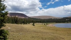
Deadhorse Lake. Time for lunch and some rest before mountain pass #2 - Deadhorse Pass.
I love looking at the Geology of the mountains - the climb up Deadhorse Pass was no exception
The views open up quickly ascending Deadhorse Pass..
More fascinating geology close to the top of the Pass.
Deadhorse Pass looking down into Rock Creek Basin. Just over the middle ridge is Crater Lake where I stayed the night before - less than 2 miles away - if your an Eagle that is.
oh the Geology..and history of this place..
West Fork of the Blacks Fork, Ejod Lake, Deadhorse Lake.
Upper Rock Creek Basin and drainage. Continent Lake is just to the right out the picture - my next stop that day.
Continent Lake. I was here last year, but without a fishing pole, and regretted it as I saw the fish swimming around in the clear water.
I have been passing these guys back and forth the whole trip - taking close to the same route as mine. Looks like their bringing home dinner from Continent Lake.
Continent Lake and Deadhorse Pass in the background. I redeemed myself and fished for an hour or so. Tired from the climbing two passes and the hike in general that day I started to look for a good spot to camp.
Remembering an area above Ledge Lake from last year I went looking for it..
This spot will do
It is worth looking for epic places to setup my tent and enjoy the views around me - especially on a trip like this one.
Fresh smoke from a forest fire to the West beyond Rocky Sea Pass.
This would be the last night on this Trip: I was in familiar territory now and started to think about a double cheese burger I could get to the next day. But one more look at the sunset..
It would not be a fulfilling scenic trip without taking the "high route" of Rock Creek Basin..
Helen Lake. Just on the other side of this ridge is Amethyst Lake on the North Slope of the range.
More high meadows and wildflowers. Not as abundant as the North Slope of the range, but still very nice..
Glady's Lake. Numerous fish rising to the surface here.
Brinkley Lake. The last lake before climbing Rocky Sea Pass.
Seriously after a full week of hiking and six mountain passes, this one looked easy to do. Plus my pack was much lighter too.
East side of Rocky Sea Pass.
The forest fire West of Rocky Sea Pass and Mirror Lake. Mount Timpanogos in the background. From here I could call my wife and let her know she could soon leave to come and pick me up at the Highline TH.
Taking a break at Pigeon Milk Spring. The water here tastes sooo good - unfiltered! Only 7+ miles to go..it has been a 12 mile day so far. Will be an almost 20 mile day. Those cheeseburgers are worth it. Plus I wanted the next day, Sunday to be a good rest day at home before the real world set in again.
I earned this scrub, and am definitely thinner around the face and waistline. You burn so many calories doing a hike like this and it is difficult to keep up. That double cheeseburger is waiting for me..
Modeling my new hat.
The burn area around Scudder Lake. Signs of new life two years after a fire came through..
It was a hot fire and burned the soil and wonder if pines will grow here anytime soon..my guess is an eventual open meadow down to and around Scudder Lake will replace the burn.
My sweet wonderful wife waiting to take me home - after the double cheese burger naturally..
..but wait there is more to this trip..
One evening I was eating my freeze-dried dinner when I realized I was looking at a Dinosaur fossil!
You can actually count the vertebre running along the top.
The size of it compared to my full sized black lab. I stepped it off to be about 18' long.
Turns out the head is on the left of the photo with the tail going past where Diesel is standing, which means the actual animal size was closer to 30' long!
Apparently it was one of these (I'm not a paleontologist, so this is my best guess) : a juvenile Elasomosarus Dinosaur! How cool is that? It lived and died here where the High Uintas now stand (current elevation over 11,000 feet) about 100 million years ago. Wow!
A fun way to end the report of an EPIC trip! It was life changing and I'm very glad I did it: Solo, in the High Uintas.
Attachments
-
 1128px-Elasomosaurus.png358.4 KB · Views: 19
 -
 20200726_151330.jpg496.1 KB · Views: 15
 -
 20200726_181610.jpg388.4 KB · Views: 12
 -
 20200727_100947.jpg356.6 KB · Views: 8
 -
 20200727_102449.jpg438.9 KB · Views: 8
 -
 20200727_111314.jpg484.2 KB · Views: 8
 -
 20200727_111349.jpg345 KB · Views: 8
 -
 20200727_111353.jpg359.1 KB · Views: 8
 -
 20200727_135132.jpg358.3 KB · Views: 8
 -
 20200728_134759.jpg330.1 KB · Views: 8
 -
 20200729_140329.jpg376.4 KB · Views: 8
 -
 20200730_132234.jpg358 KB · Views: 8
 -
 20200730_142010.jpg306.2 KB · Views: 8
 -
 20200730_150010.jpg497.1 KB · Views: 7
 -
 20200730_150927.jpg508.9 KB · Views: 8
 -
 20200730_151827.jpg346.2 KB · Views: 9
 -
 20200730_152144.jpg488.3 KB · Views: 9
 -
 20200730_153714.jpg317.1 KB · Views: 9
 -
 20200730_153719.jpg350.4 KB · Views: 9
 -
 20200730_154404.jpg369.1 KB · Views: 10
 -
 20200730_154557.jpg358.1 KB · Views: 13
 -
 20200730_154716.jpg616.6 KB · Views: 13
 -
 20200730_203433.jpg128.1 KB · Views: 12
 -
 20200731_122454.jpg341.1 KB · Views: 9
 -
 20200731_122455.jpg366.9 KB · Views: 10
 -
 20200731_122540.jpg481.7 KB · Views: 11
 -
 20200731_123213.jpg358.9 KB · Views: 12
 -
 20200731_123337.jpg577 KB · Views: 11
 -
 20200731_140100.jpg377 KB · Views: 10
 -
 20200731_183930.jpg434.5 KB · Views: 10
 -
 20200731_183943.jpg331.7 KB · Views: 10
 -
 20200731_185716.jpg288.4 KB · Views: 11
 -
 20200731_185821.jpg300.9 KB · Views: 10
 -
 20200801_145116.jpg575.5 KB · Views: 10
 -
 20200801_145121.jpg489.1 KB · Views: 10
 -
 20200801_145340.jpg347.1 KB · Views: 10
 -
 20200801_150537.jpg207.8 KB · Views: 12
 -
 Dino 5.jpg493.2 KB · Views: 14
Last edited: