Follow the Cows, but Never Trust the Cows
Reaching the low saddle between the La Rabia and San Sebastain drainages you will find yourself faced with a bewildering selection of cow trails to follow. Knowing roughly the way I needed to go, I would just pick the one that looked the most traveled and follow it until it faded out to nothing. Then I would just head in the general direction I wanted to go until I picked up another likely looking cow trail in the right direction.
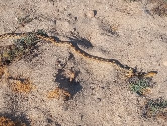
A RARE SIGHTING IN THE DESERT OF BAJA
It is not only me, Crosby says “The trail ahead to Mission San Borja was a total mystery, as not one of early travel accounts was conclusive.” (The King's Highway In Baja California, page 136). Genevieve and Kevin at www.caminorealbaja.com have been looking for, and documenting the El Camino Real for over twenty years, says this about this section of the El Camino Real “ECR travels up this canyon to continue northward; however, it is in bad shape and difficult to find.” (Note on Waypoint #G103, downloaded 3/14/24). The El Camino Real is not an easy trail to follow. It is wild, overgrown, washed away, and poorly documented.
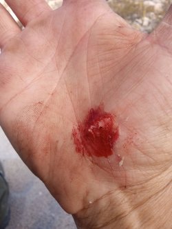
A MOMENTS DISTRACTION LEADS TO A FALL
The evening finds me a little ways up a unnamed drainage with the wind blowing and no good campsites. The folks over at www.caminorealbaja.com have spent years documenting the trail and I remember one comment they made was that sometimes they would camp right on the trail because it was the only open spot available. I wasn't quite ready to do that so after another 15 minutes of walking I find a passable spot.
A GOOD SECTION OF TRAIL NEAR CAMP FOR THE NIGHT

The next morning I pass my wrong turn from last year, and it is not long before I am up on the mesa. Crossing a large drainage and I find myself at the point in 2024 that I turned around. Excitement builds as I pass my turn around point from last year and approach a clearly defined section of the El Camino Real. You can even see it on Google Earth as a gray line running almost arrow straight across the mesa at these coordinates, 28 26.084'N 113 34.875'W.
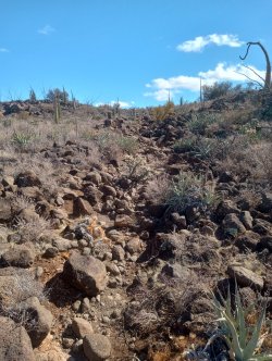
Sometimes, when telling others about an adventure, a person can be reluctant about saying something negative about the experience. So, it is with a heavy heart that I have to say how disappointed I was with this section of trail. It is more obvious from space then it is from the ground, and it very rocky and hard to walk on. Walking it was a little sad because it did not match my imagination. Damn, imagination!
A ROCKY SECTION NEAR MESA LAS PALMAS
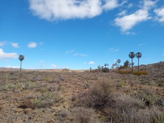
Dropping off the far side of the mesa I was surprised to see palm trees, in all my reading of accounts of traveling on the ECR not one had mentioned the all the palm trees on the Mesa las Palmas. Crosby has a section of his book titled “The Land of Skyline Palms” (The King's Highway In Baja California, page 140) but his notes of the route seems to vary from mine. It appears to be in the wrong order. Crosby says that first came the view into Arroyo San Sebastian (he calls it Arroyo Tres Palmas), then later that evening he says “In the last rays of sun there was another strange sight. The highest ridges of the sierra on the east consised(sp) of tall pink stone cantiles, or palisades. Growing out of crevices, apparently in solid rock, were dozens, if not hundreds, of skyline palms.” (The King's Highway In Baja California, page 141).
Most likely we are talking about different locations, and Crosby does not mention Mesa las Palmas at all. It is quite a striking view though, to be crossing a large flat mesa and upon reaching the edge is a slightly lower mesa were one finds themselves looking down on large groups of palm trees.
Edie Littlefield Sundby does mention Mesa las Palmas in her book, but is odd that she does not mention the numerous plam trees! She writes “We camped atop Mesa Las Palmas, an enormous mesa covered in thorny brush less than a foot high.” (The Mission Walker, page 211, 212)
Ones gets used to seeing palm trees in the canyons and arroyos, not scattered across the mesa tops. Some of the stands are quite dense, at other spots it might be just a few scattered plam trees on the open mesa top. Funny, Crosby had almost the same thoughts “It was hard to believe. Palms in arroyos were now commonplace, almost overlooked. But these large plants in such arid country on rocky summits defied explanation.” (The King's Highway In Baja California, page 141)
PALM TREES ON THE MESA LAS PALMAS
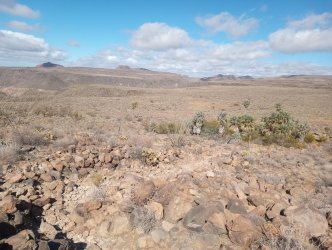
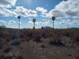
After leaving the Mesa las Palmas I come upon a view mentioned in Crosby's book and I too leave the trail to admire an amazing vista. “...I found myself looking straight down on the tops of innumerable palms in the very bottom of the waterway. It was a dizzyng sight, especially as the first hundred feet below was an absolutly sheer drop. Paul came over and whistled in awe at the setting.” (Harry Crosby, The King's Highway In Baja California, page 141)
VIEW INTO ARROYO SAN SEBASTIAN

For the second time on this trip I lose the trail completely and spend way too much time going the wrong way. After admiring the view down into Arroyo San Sebastian I was under the mistaken impression that the trail followed along it for a bit.
When I didn't pick up the trail in a couple of hundred yards I pull out the GPS and see that the trail is shown far off to my left. It doesn't seem right but I zig-zag across the mesa top veering slightly to my left looking for it. I am ready to give up and I climb up a rocky outcropping to admire a view of the next drainage. While soaking in the view I see the trail, still further to my left descending into a maze of canyons.
I am discouraged and know that this is it, I am not going hundreds of feet down this canyon to just turn around in a few hours and climb back out. I decide to walk over to the trail though and follow it back to where I lost it. It turns out when I walked over to look down into the San Sebastian drainage the trail made a sharp left in that area.
MY 2025 TURN AROUND SPOT, TRAIL GOES FROM THE MIDDLE OF THE LEFT EDGE TO THE BOTTOM OF THE CANYON
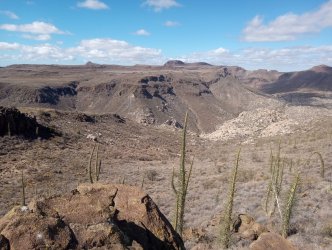
Turning around, I start heading back and end up camping at San Sebastian that night. Around 10pm my air mattress goes flat and after airing it up it will only hold air for about 45 minutes. I have a restless night sleep.
I am off early the next morning wondering and hoping if I can make it to the car tonight. It is parked in Juan's yard so I do not want to arrive at or after sunset. With a little over a liter of water I start off. In some spots I lose the trail but with the knowledge from the last couple of days I soon pick it up again.
SECTION OF TRAIL THAT IS VISIBLE ON GOOGLE EARTH
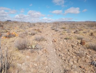
In the early afternoon, miles from the car I run out of water. It is, generally, a pleasant hike and the weather is mild so I just push on. From time to time I see my tracks from two days ago and every now and then I will see one of my tracks overlain with a Mountain Lion track!
Even without water I feel good, it is getting late, but I am on the home stretch. The hiking is good, the late afternoon desert feels welcoming with the doves calling. Around 5pm I reach the car, Juan and two others come out and greet me. He ask if I want to use the phone or the internet, I 'Thank' him but decline.
I drive well into the night, hoping that I am taking the correct turns at all the junctions. Once out of the mountains I am able to get a cell signal and route to Guerrero Negro.
Lost on the Llano el Berrendo or You Can't Get to Guerrero Negro From Here
At times on the ECR you can look into the west and see the the Pacific Ocean and Scammon's Lagoon. Crosby wrote “There….we could see some sixty miles to the expanse of Scammon's Lagoon…” and “In that sheet of inland water I knew were the California gray whales in the full swing of their annual visit.” (The King's Highway In Baja California, page 140, 141). Upon seeing Scammon's Lagoon it struck me that it might be whale watching season down there and perhaps I should go.
With Goggle guiding me, I drive far out onto the plains. Finding a small turn out I set up camp, to the sounds of coyotes howling off in the distance. I ever since I was bitten by one while sleeping, I am uneasy camping when I know there are coyotes about.
The morning finds me unmolested by coyotes and the sun still hiding behind the mountains to the east. I fly the drone for a little while, when I find an interesting trail. I do a short 3 mile hike out to the trail, and along it for a bit, before heading back to the car to pack up and continue on to Guerrero Negro.
I no longer have a signal, so Goggle will be no help, but I have a GPS with Baja downloaded, a copy of the Baja Atlas so I should be able to make my way out. Little did I know that my decision to only put in $300 Pesos (about $15 USD/4 gallons) of gas in the car 5 days ago would cause me so much stress. The drive started well. Drive down this dirt road, to this dirt road, drive to this Rancho, turn right, drive to this road and turn left and then it would almost be a straight shot to the highway.
DIRT ROAD OUT ONTO THE PLAINS

Llano el Berrendo(ANTELOPE PLAINS) GUERRERO NEGRO IS SOMEWHERE OVER THE HORIZON
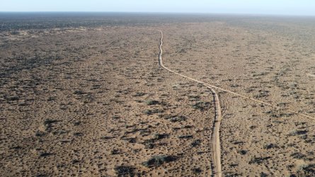
First 3 steps went exactly as planned, when suddenly I came upon a fence and road closed sign. Hmmm, by the map and GPS I can go here, turn there and go here and then be back on track. Off I go, the first two steps are good, when the road just peters out in the desert.
OK, lets try this road, to this road….Again all good until I come to a gate, a LOCKED gate. At this point I was down to about an 1/8 of a tank of gas. This was getting a little serious. My plan now was to us my maps, but to also stay on the most traveled path.
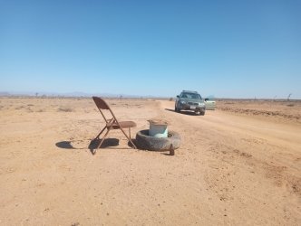
After 3 more dead ends, I am getting worried. I make my way back almost to where I started in the morning and this time I go in the opposite direction from the way I went after leaving camp. Miles later I come upon a well traveled road that the map and GPS show goes straight to the highway. I hope so because I expect the fuel light to come on any time now.
LOOKS LIKE SOMEONE ELSE GOT LOST AND WENT MAD
Soon, off in the distance, I can see trucks going down what I assume is the highway. My low fuel light comes on as I reach pavement, but it is going to be alright. I make it to the gas station just north of Guerrero Negro where I say “Fill it up, please!”
TO BE CONTINUED...You can read PART ONE here and I do need to add little more at some point
Reaching the low saddle between the La Rabia and San Sebastain drainages you will find yourself faced with a bewildering selection of cow trails to follow. Knowing roughly the way I needed to go, I would just pick the one that looked the most traveled and follow it until it faded out to nothing. Then I would just head in the general direction I wanted to go until I picked up another likely looking cow trail in the right direction.
A RARE SIGHTING IN THE DESERT OF BAJA

It is not only me, Crosby says “The trail ahead to Mission San Borja was a total mystery, as not one of early travel accounts was conclusive.” (The King's Highway In Baja California, page 136). Genevieve and Kevin at www.caminorealbaja.com have been looking for, and documenting the El Camino Real for over twenty years, says this about this section of the El Camino Real “ECR travels up this canyon to continue northward; however, it is in bad shape and difficult to find.” (Note on Waypoint #G103, downloaded 3/14/24). The El Camino Real is not an easy trail to follow. It is wild, overgrown, washed away, and poorly documented.
A MOMENTS DISTRACTION LEADS TO A FALL

The evening finds me a little ways up a unnamed drainage with the wind blowing and no good campsites. The folks over at www.caminorealbaja.com have spent years documenting the trail and I remember one comment they made was that sometimes they would camp right on the trail because it was the only open spot available. I wasn't quite ready to do that so after another 15 minutes of walking I find a passable spot.
A GOOD SECTION OF TRAIL NEAR CAMP FOR THE NIGHT

The next morning I pass my wrong turn from last year, and it is not long before I am up on the mesa. Crossing a large drainage and I find myself at the point in 2024 that I turned around. Excitement builds as I pass my turn around point from last year and approach a clearly defined section of the El Camino Real. You can even see it on Google Earth as a gray line running almost arrow straight across the mesa at these coordinates, 28 26.084'N 113 34.875'W.
Sometimes, when telling others about an adventure, a person can be reluctant about saying something negative about the experience. So, it is with a heavy heart that I have to say how disappointed I was with this section of trail. It is more obvious from space then it is from the ground, and it very rocky and hard to walk on. Walking it was a little sad because it did not match my imagination. Damn, imagination!
A ROCKY SECTION NEAR MESA LAS PALMAS

Dropping off the far side of the mesa I was surprised to see palm trees, in all my reading of accounts of traveling on the ECR not one had mentioned the all the palm trees on the Mesa las Palmas. Crosby has a section of his book titled “The Land of Skyline Palms” (The King's Highway In Baja California, page 140) but his notes of the route seems to vary from mine. It appears to be in the wrong order. Crosby says that first came the view into Arroyo San Sebastian (he calls it Arroyo Tres Palmas), then later that evening he says “In the last rays of sun there was another strange sight. The highest ridges of the sierra on the east consised(sp) of tall pink stone cantiles, or palisades. Growing out of crevices, apparently in solid rock, were dozens, if not hundreds, of skyline palms.” (The King's Highway In Baja California, page 141).
Most likely we are talking about different locations, and Crosby does not mention Mesa las Palmas at all. It is quite a striking view though, to be crossing a large flat mesa and upon reaching the edge is a slightly lower mesa were one finds themselves looking down on large groups of palm trees.
Edie Littlefield Sundby does mention Mesa las Palmas in her book, but is odd that she does not mention the numerous plam trees! She writes “We camped atop Mesa Las Palmas, an enormous mesa covered in thorny brush less than a foot high.” (The Mission Walker, page 211, 212)
Ones gets used to seeing palm trees in the canyons and arroyos, not scattered across the mesa tops. Some of the stands are quite dense, at other spots it might be just a few scattered plam trees on the open mesa top. Funny, Crosby had almost the same thoughts “It was hard to believe. Palms in arroyos were now commonplace, almost overlooked. But these large plants in such arid country on rocky summits defied explanation.” (The King's Highway In Baja California, page 141)
PALM TREES ON THE MESA LAS PALMAS


After leaving the Mesa las Palmas I come upon a view mentioned in Crosby's book and I too leave the trail to admire an amazing vista. “...I found myself looking straight down on the tops of innumerable palms in the very bottom of the waterway. It was a dizzyng sight, especially as the first hundred feet below was an absolutly sheer drop. Paul came over and whistled in awe at the setting.” (Harry Crosby, The King's Highway In Baja California, page 141)
VIEW INTO ARROYO SAN SEBASTIAN

For the second time on this trip I lose the trail completely and spend way too much time going the wrong way. After admiring the view down into Arroyo San Sebastian I was under the mistaken impression that the trail followed along it for a bit.
When I didn't pick up the trail in a couple of hundred yards I pull out the GPS and see that the trail is shown far off to my left. It doesn't seem right but I zig-zag across the mesa top veering slightly to my left looking for it. I am ready to give up and I climb up a rocky outcropping to admire a view of the next drainage. While soaking in the view I see the trail, still further to my left descending into a maze of canyons.
I am discouraged and know that this is it, I am not going hundreds of feet down this canyon to just turn around in a few hours and climb back out. I decide to walk over to the trail though and follow it back to where I lost it. It turns out when I walked over to look down into the San Sebastian drainage the trail made a sharp left in that area.
MY 2025 TURN AROUND SPOT, TRAIL GOES FROM THE MIDDLE OF THE LEFT EDGE TO THE BOTTOM OF THE CANYON

Turning around, I start heading back and end up camping at San Sebastian that night. Around 10pm my air mattress goes flat and after airing it up it will only hold air for about 45 minutes. I have a restless night sleep.
I am off early the next morning wondering and hoping if I can make it to the car tonight. It is parked in Juan's yard so I do not want to arrive at or after sunset. With a little over a liter of water I start off. In some spots I lose the trail but with the knowledge from the last couple of days I soon pick it up again.
SECTION OF TRAIL THAT IS VISIBLE ON GOOGLE EARTH

In the early afternoon, miles from the car I run out of water. It is, generally, a pleasant hike and the weather is mild so I just push on. From time to time I see my tracks from two days ago and every now and then I will see one of my tracks overlain with a Mountain Lion track!
Even without water I feel good, it is getting late, but I am on the home stretch. The hiking is good, the late afternoon desert feels welcoming with the doves calling. Around 5pm I reach the car, Juan and two others come out and greet me. He ask if I want to use the phone or the internet, I 'Thank' him but decline.
I drive well into the night, hoping that I am taking the correct turns at all the junctions. Once out of the mountains I am able to get a cell signal and route to Guerrero Negro.
Lost on the Llano el Berrendo or You Can't Get to Guerrero Negro From Here
At times on the ECR you can look into the west and see the the Pacific Ocean and Scammon's Lagoon. Crosby wrote “There….we could see some sixty miles to the expanse of Scammon's Lagoon…” and “In that sheet of inland water I knew were the California gray whales in the full swing of their annual visit.” (The King's Highway In Baja California, page 140, 141). Upon seeing Scammon's Lagoon it struck me that it might be whale watching season down there and perhaps I should go.
With Goggle guiding me, I drive far out onto the plains. Finding a small turn out I set up camp, to the sounds of coyotes howling off in the distance. I ever since I was bitten by one while sleeping, I am uneasy camping when I know there are coyotes about.
The morning finds me unmolested by coyotes and the sun still hiding behind the mountains to the east. I fly the drone for a little while, when I find an interesting trail. I do a short 3 mile hike out to the trail, and along it for a bit, before heading back to the car to pack up and continue on to Guerrero Negro.
I no longer have a signal, so Goggle will be no help, but I have a GPS with Baja downloaded, a copy of the Baja Atlas so I should be able to make my way out. Little did I know that my decision to only put in $300 Pesos (about $15 USD/4 gallons) of gas in the car 5 days ago would cause me so much stress. The drive started well. Drive down this dirt road, to this dirt road, drive to this Rancho, turn right, drive to this road and turn left and then it would almost be a straight shot to the highway.
DIRT ROAD OUT ONTO THE PLAINS

Llano el Berrendo(ANTELOPE PLAINS) GUERRERO NEGRO IS SOMEWHERE OVER THE HORIZON

First 3 steps went exactly as planned, when suddenly I came upon a fence and road closed sign. Hmmm, by the map and GPS I can go here, turn there and go here and then be back on track. Off I go, the first two steps are good, when the road just peters out in the desert.
OK, lets try this road, to this road….Again all good until I come to a gate, a LOCKED gate. At this point I was down to about an 1/8 of a tank of gas. This was getting a little serious. My plan now was to us my maps, but to also stay on the most traveled path.
After 3 more dead ends, I am getting worried. I make my way back almost to where I started in the morning and this time I go in the opposite direction from the way I went after leaving camp. Miles later I come upon a well traveled road that the map and GPS show goes straight to the highway. I hope so because I expect the fuel light to come on any time now.
LOOKS LIKE SOMEONE ELSE GOT LOST AND WENT MAD

Soon, off in the distance, I can see trucks going down what I assume is the highway. My low fuel light comes on as I reach pavement, but it is going to be alright. I make it to the gas station just north of Guerrero Negro where I say “Fill it up, please!”
TO BE CONTINUED...You can read PART ONE here and I do need to add little more at some point
Last edited:
