Wind River offtrail route questions

Diane Greer

Member
Joined
Nov 28, 2013
Messages
49
I am planning a backpack in the Wind River range and would like to explore some new areas. On several backpacks I have hiked up the New Forks trail to the Lozier Lakes and then descended to Trail Creek Park. This time I would like to go past the Lozier Lakes to what some call New Fork Pass, the highest point along the trail, and then turn south, plotting a course across the high plateau to the west of Glover Peak before dropping down to the No Names Lakes. It looks like the most efficient route heads toward lake 11192 and then follows the drainages down to the No Names. It also looks like you could visit the Thompson/Hidden Lakes, possibly camping there and then drop down to the No Names.

See: Click here to view on CalTopo
Has anyone explored this area have suggestions?

Also, I am looking at the pass between Wall Lake and Upper Golden Lake. From the north end of Wall Lake the route to the pass heads east past lake 10842 to the divide. From the divide the best route seems to descend to Lake 11065 and then following the drainage down to Upper Golden Lake. Again, anyone have any experience with the route? What is the drop like into the Golden Lakes via Lake 11065? See: Click here to view on CalTopo
Thanks!
 
Have a plan to go over Wall Pass this year. Pallister labels it "difficult but no specialized mountaineering gear needed". A few years back, ran into 2 guys at Upper Golden that took that route back to Wall. Didn't hear about them dying, so it's doable. From Upper Golden I remember seeing a lot of boulders along Middle Fk BLC and heavy trees on both sides. I came in via Fall Ck and went back via Hay/Round Mtn. Pallister's route (modified from Kelsey's) was from Camp Lake. That's close to what we have planned. Profile shows the pass is steep on both sides. Looks like most routes in Caltopo stay on the East side of the creek.
 
Thank you for the feedback. I have looked at both the Kelsey and Pallister routes. Interesting that the routes on CalTopo go a different way. I was hoping that it might be an easier crossing.

Our current plan is to enter via Elkhart and then follow Pole Creek to the Cook Lakes and Wall Lake. We have always wanted to spend some time exploring the upper Pole Creek valley (north of Wall Lakes). From there the goal is to stay high along the western side of the divide by finding an efficient means of crossing over to the Golden Lakes. We would then go over Hay Pass before traveling along Glacier and Long Lakes to Europe Canyon.

Would love to hear about your experience going over Wall Pass. Have a great trip!
 
Last edited:
Have a plan to go over Wall Pass this year. Pallister labels it "difficult but no specialized mountaineering gear needed". A few years back, ran into 2 guys at Upper Golden that took that route back to Wall. Didn't hear about them dying, so it's doable. From Upper Golden I remember seeing a lot of boulders along Middle Fk BLC and heavy trees on both sides. I came in via Fall Ck and went back via Hay/Round Mtn. Pallister's route (modified from Kelsey's) was from Camp Lake. That's close to what we have planned. Profile shows the pass is steep on both sides. Looks like most routes in Caltopo stay on the East side of the creek.
I'm jealous! That is a great area - I did "Wall Pass" a few years ago and can confirm it's nothing crazy, but one of the more "wild" (but non-technical) in the Winds. It really isn't that steep either - by Winds standards at least. Basically no sign of human activity beyond the upper lakes on either side. Give me a shout if you want some beta, but sounds like you don't need it. Enjoy!
 
I'm jealous! That is a great area - I did "Wall Pass" a few years ago and can confirm it's nothing crazy, but one of the more "wild" (but non-technical) in the Winds. It really isn't that steep either - by Winds standards at least. Basically no sign of human activity beyond the upper lakes on either side. Give me a shout if you want some beta, but sounds like you don't need it. Enjoy!
Just curious -- did your route take you down the east side of Wall Pass to Lake 10,787 (i.e. the north side of Camp Pass) or to Lake 11065 leading to Upper Golden Lake (the route shown on the Caltopo map)?
 
Just curious -- did your route take you down the east side of Wall Pass to Lake 10,787 (i.e. the north side of Camp Pass) or to Lake 11065 leading to Upper Golden Lake (the route shown on the Caltopo map)?
I curled up towards Lake 10,787', but either way goes - depending on whether you're headed towards Alpine Lakes or Golden Lakes.

My route was actually a bit odd, since I followed the Divide/ridge over to points 12,846' and 12,314' before descending. (Definitely not the most efficient - but fun. :lol:) If I do it again, I want to follow the Divide down to Angel Peak before descending - or do Angel Pass and then ascend the eastern aspect of Angel Peak and follow the Divide north. Now you've just got me convinced to head out there again. ;)
That is the beauty of the winds. There is always some new route to explore! Endless possibilities. Thank you for the information. Have a great summer.
 
There's a route from L10,787 to Angel Pass that @Bob planned. Discussion & CalTopo on Angel Pass report. Different from the route in white above. Look forward to hearing more about the Lozier Lakes area too. Haven't been up that way, though heard there was good fishing there.
 
There's a route from L10,787 to Angel Pass that @Bob planned. Discussion & CalTopo on Angel Pass report. Different from the route in white above. Look forward to hearing more about the Lozier Lakes area too. Haven't been up that way, though heard there was good fishing there.
Found a good trip report on area to the south of Lozier Lakes. on the Great Outdoor Shop blog: https://www.greatoutdoorshop.com/blog/2013/09/07/new-fork-lakes-trailhead-lozier-lakes-loop/ . The Lower Hidden and Thompson Lakes had good fishing for brook trout. (This was back in 2013.)
 
Interesting Caltopo you posted. All the white lines trails plotted trips? If so, gives a idea of the worst traveled areas.
 
Interesting Caltopo you posted. All the white lines trails plotted trips? If so, gives a idea of the worst traveled areas.
Yeah - not sure that was the intention when CalTopo added it, but it is nice. ;)

It's also interesting because there are two settings: one is all plotted routes and the other is just recorded tracks. For your average area/route the ratio of routes:tracks is pretty consistent, so for highly publicized - but relatively difficult - routes like Skurka's HRs or similar it's clear there are a lot more plotted routes than actual tracks. It's not very scientific, but fun to prognosticate from nonetheless.
 
hmmm .... this is the only caltopo i have seen like that.
 
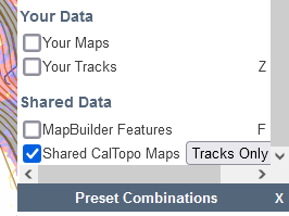
On the right hand side of Caltopo, is a Map Layers window. (On a small screen you need to hit the layers icon). At the bottom of the window is a "Shared Data" subheading. Here you can turn on Mapbuilder Featuers and Shared Caltopo maps. This lets you see the maps/routes that others wish to share. The white lines are a combination of actualy shared gps route and people plotting out potential routes on the map. It is always intereseting to see the routes people have taken. Good source for thinking about new routes through the winds and other places.
 
Ok... See it.... Have mine set with map types displayed, don't usually ones like map builder .. so hadn't seen that. Have used the caltopo.. find to see other shared maps.

However there are a lot just drawn up tracks that people think would be good... Not actually done tracks.
 
Ok... See it.... Have mine set with map types displayed, don't usually ones like map builder .. so hadn't seen that. Have used the caltopo.. find to see other shared maps.

However there are a lot just drawn up tracks that people think would be good... Not actually done tracks.
You can see the tracks people have actually done since there are more points in the track. It is really a combination of both.
 
You can see the tracks people have actually done since there are more points in the track. It is really a combination of both.
I had never seen these before and am checking them out now. But I'm not understanding how you can tell the difference between potential and actual. Can you explain?
 
You can left click on the of the white lines designating share maps. A menu will pop up showing you all the shared maps show in the area where you clicked. Some will say things like, "some potential hikes". Other descriptions will say green lines are the ones I have done, red are the one I want to do. For maps that sound interesting, you can then click on the link for the map, which will open the shared map. Lots of great information but you need to spend some time to find the hidden jewels.
 
Last edited:
I had never seen these before and am checking them out now. But I'm not understanding how you can tell the difference between potential and actual. Can you explain?
There's a couple ways: the easiest is to select "Tracks Only" instead of the other options. You still might get a couple "routes" that the user manually changed to "tracks", but it generally reflects actual tracking.

If you're looking at a specific path - as @Diane Greer points out - a "track" is likely to have many more individual data points than a "route", so you can use that as well.

Additionally, when clicking on a path you can see the description - or even go to that user's map - and infer a lot from that information.
 
A lot easier than it used to be .... Have to scroll thru 100s of route listings in caltopo find blog.
 
Similar threads
Thread starter Title Forum Replies Date
D Wind River-like Zone in Canada Backpacking 5
meowtaingal Wind river high route mid september Trip Planning 7
W Greetings from the West Side of the Winds (Wind River range) Noobs: Introduce yourself! 5
marquiri Wind River Range - Angel Pass Trip Planning 24
Mikjik86 Backpacking The Wind River Range - Wyoming, September 2022 Trip Reports 3
R Wind River Range: Green River Lakes/Clarks Trail/Porcupine Creek Trail Trip Planning 3
Mikjik86 Another Wind River Trip Planning! Elkhart/Titcomb/Knapsack/Shannons Pass loop back to Elkhart, or continue to Green River Lakes Trailhead? Trip Planning 10
wsp_scott Wind River Range Sept 2021 (part 2) Backpacking 4
wsp_scott Wind River Range Sept 2021 (part 1) Backpacking 16
B Wind river range mid sept. Trip Planning 8
andyjaggy Wind River Range Roberts Mountain Trip Planning 4
marquiri Wind River Range - September 2022 Trip Planning 31
TheMountainRabbit Northern Wind River Traverse (Bridger/Fitzpatrick Wilderness) - September 2021 Backpacking 16
D Wind River Blowdown Trip Planning 2
westy Wind River Range Backpacking 4
Artemus Wind River Mountains Conditions 2021 Trip Planning 17
eobie Wind River Blowdowns Situtation... Trip Planning 14
wsp_scott Wind River Range (beginning of Sept 2021) Meet Up (Members Only) 11
TheMountainRabbit NW Wind River Range (Bridger Wilderness) - August 2020 Backpacking 3
travel2walk trip report: Wind River Range – Ross Lakes, Bear Basin, Grasshopper Glacier, & Dinwoody Creek loop, Aug-Sep 2020 Trip Reports 41
marquiri Wind River Range - Green River Lakes Trailhead Trip Planning 9
Gunnahafta Green River <> Big Sandy WIND RIVER RANGE Trip Planning 1
M 5 days Green > Elk Wind River route advice August 17th Trip Planning 9
Matt Van Natta HELP: Wind River Range, Baker Lake to Green River Lakes Trip Planning 7
T Grizzly bears in Wind River Mountains Noobs: Introduce yourself! 12
Dreamer Wind River Dreaming | Summer 2019 July 17 - July 29 | Green River Lakes - Elkhart Park Backpacking 14
Artemus Wind River Mountains Snowpack 2019/2020 Trip Planning 12
S Backcountry camping tips for Wind Rivers - upper Green River valley via canoe Trip Planning 5
TrektheWorld Wind River Range 5 Day Loop Backpacking 16
Hiker Seth Thinking about this Wind River Route. Trip Planning 11
H Wind River Range route planning Trip Planning 6
Dreamer Wind River Dreaming | Summer 2014 the first few days July 9 - 14 Backpacking 5
Artemus Wind River Mountain Conditions 2019 Trip Planning 62
10KFly Wind River Range in Late September Trip Planning 6
b.stark Wind River Range 2009 "From The Vault" Backpacking 9
blueeyes Wind River Range August 2018 Backpacking 11
Lowro East Temple Peak - Wind River Range Backpacking 13
DuneElliot Backpacking Wyoming's Wind River Range, August 2018 Backpacking 4
b.stark Wind River Range 2007 "From The Vault" Backpacking 4
Wolverine1875 Wind River Range: Llama Trekking from Dickinson Park to The Cirque of The Towers Trip Planning 19
Dreamer Wind River Dreaming | Summer 2012 trip 3 July 22 - August 8 | part two Backpacking 2
Bob Wind River Mountains Trip Planning 2
N Wind River and Medicine Bow Peak July 6-13 Backpacking 3
Curt Wind River Range - July 2018 Backpacking 26
DaveNC Wind River Range August-September - with time to roam Trip Planning 8
Dreamer Wind River Dreaming | Summer 2012 trip 3 July 22 - August 8 Backpacking 19
pstm13 Texas Pass Cirque of Towers Lower Wind River Range August 2018 Trip Planning 7
Artemus Wind River Mountains Conditions 2018 Trip Planning 45
DuneElliot Wind River Range, WY: August 2018 Trip Planning 3
Cburton A week along the Continental Divide in Wind River Range Backpacking 20

Similar threads

Back
Top