Uintas Conditions 2019

Hey everyone, looking at various snotels around the Uintas, it looks like in the next 3-5 days, most snotel locations will be melted. Any thoughts on whether the 4th of July weekend will be accessible for camping around 10500? Sounds like its super wet at the moment, but will this change rapidly with the high temps over the next week or will that just make it worse?
 
Hey everyone, looking at various snotels around the Uintas, it looks like in the next 3-5 days, most snotel locations will be melted. Any thoughts on whether the 4th of July weekend will be accessible for camping around 10500? Sounds like its super wet at the moment, but will this change rapidly with the high temps over the next week or will that just make it worse?
I'm no expert, but I don't think a week is going to make much of a difference in the wetness right now, and yes, it may be even worse in a week since there is still plenty of snow lingering right now. Even in early July in a normal year, you're going to have a lot of soggy ground to cover. And tons of mosquitoes to battle. It'll definitely be doable, and with enough searching, you'll probably be able to find places to camp, but go expecting it to be type two fun at times.

Edit: I guess I should ask. Are you planning to backpack or are you talking about just pulling in to a camp site off MLH with your car?

We are backpacking so sounds like we may definitely need to do some hunting as we battle the snow/puddles/extreme sogginess/mosquito traps. We will be prepared for type two fun or settling for a lower basecamp and doing day hikes to higher elevations.
 
We are backpacking so sounds like we may definitely need to do some hunting as we battle the snow/puddles/extreme sogginess/mosquito traps. We will be prepared for type two fun or settling for a lower basecamp and doing day hikes to higher elevations.
79138
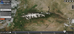
Here's yesterday's satellite image of the range. Even more snow than I expected to see. The warm temps over the next week will be helpful in melting a lot of that, but all that water will be rushing down the drainages or sitting the meadows for a good while.

On the bright side, you may have a lot more places to yourselves than you would on the 4th of July in a normal season!
 
West Fork Blacks Fork still running full and fast.

a701d27e34b671c0d821e04388ec98c2.jpg


Sent from my iPhone using Tapatalk
 
Wow! What a difference a week makes. Hiked the Middle Fork Blacks Fork Ridge Way trail today. Probably a trip report coming on that one. Anyway... rivers are down some... easier to cross. Still lots of running water *and* the mosquitoes are hungry :( Ate me alive most of the day. High country still has significant snow. Pictures to come.
 
I know Tokawanna Peak. I don't know Squaw Benchmark.
Are you in EFBF? Is Squaw Benchmark the bench above Bobs Lake?

Was there much mud?
 
I know Tokawanna Peak. I don't know Squaw Benchmark.
Are you in EFBF? Is Squaw Benchmark the bench above Bobs Lake?

Was there much mud?

Squaw Benchmark is over by Red Castle Lake. I'm on the ridge above EFBF. Right about at the blue circle..

79381
 
Last edited:
Oh and mud wasn't too bad. The meadows are all still really wet though. Not a dry feet day.
 
Has anyone been over Dead Horse Pass? My guess there would be some post holing coming down the north side. Also, is the road from Little Lyman to the ford on the West Fork Blacks dry enough to drive? Thanks...
 
Has anyone been over Dead Horse Pass? My guess there would be some post holing coming down the north side. Also, is the road from Little Lyman to the ford on the West Fork Blacks dry enough to drive? Thanks...

This is the snow coverage as of Sunday, 7/7..

https://caltopo.com/map.html#ll=40.74503,-110.67388&z=15&b=sentinel_tc-0&a=mba

The snow I was on on Saturday above EFBF at 11,150 ft was slushy. I think post holing on the north side of Dead Horse Pass would be the least of your worries. I haven't been on WFBF road but was on MFBF and its very muddy. 4wd mandatory.
 
I called the Mt. View office and they say the road up the West Fork of the Blacks Fork is fine. My guess is the ford is impassable and you'd have to wade across it. She also said that there was snow above around 10,000 ft and a lot of the trails were muddy. Mt. View is on the north slope. The Caltopo shows a lot of white but a lot of the area had cloud cover. We're planning on doing a thru hike from Hayden Pass over to the West Fork Blacks. Might just be an in and out if there's too much snow.
 
I called the Mt. View office and they say the road up the West Fork of the Blacks Fork is fine. My guess is the ford is impassable and you'd have to wade across it. She also said that there was snow above around 10,000 ft and a lot of the trails were muddy. Mt. View is on the north slope. The Caltopo shows a lot of white but a lot of the area had cloud cover. We're planning on doing a thru hike from Hayden Pass over to the West Fork Blacks. Might just be an in and out if there's too much snow.

Report back and let us know how it went!
 
Back
Top