- Joined
- Dec 5, 2017
- Messages
- 1,062
When current events make you want to crawl into a hole and escape reality, the Grand Canyon is the perfect hole to stay in for awhile. I spent 5 magical days reveling in the splendor of our natural world - gorgeous canyons, rocks, streams, waterfalls, cacti, trees, flowers, rocks, river, moon, constellations, planets, shooting stars, and did I say rocks? So many fabulous rocks! We lucked out with great weather (October 22-26). Days and nights were equally beautiful, and since we always slept without a tent or rainfly we were treated to a fantastic show all night long - and nights were definitely long (sunset 5:45ish to sunrise 6:45ish). The magnificent Colorado River gets lots of attention as it goes through the middle of the canyon, but the side canyons - Deer and Tapeats on our route - are magnificent as well. The power of water is remarkable; I feel so fortunate to have explored Deer Creek, the Colorado River, Tapeats Creek, and Thunder River. This trip will stay with me for a long time.
Travel Day - fly to Vegas, drive to Kanab
Even before we arrived at the Grand Canyon, the trip was off to a great start. When flying, I love getting a window seat and looking down below when the skies are clear. Luck was with me, for as we flew near the Vermillion Cliffs I was on the correct side of the plane to see some of my favorite spots from previous trips: Coyote Buttes North (The Wave), Coyote Buttes South, Buckskin Gulch, etc. I was thrilled to capture this image:

Once we landed, we enjoyed beautiful scenery on our drive to Kanab, had a great dinner, and got our packs ready for the morning. As usual, I had a mix of emotions before starting a big trip: excited and nervous. A lot of anticipation had built up over many months - researching the route, deciding to hike counter-clockwise, filling out a permit request, getting everything we had requested, doing more research, and planning, planning, planning. How would my knees do? What would it be like carrying all that water on Day 1 (5 liters plus an extra gallon to cache for our final night)? Would the cache be waiting for us at the end? Would I manage the big uphill? What about the Tapeats crossing? etc etc etc. I couldn't believe the trip was finally upon us!
Day 1 - Bill Hall TH to Esplanade
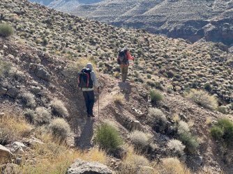
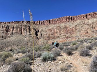
We left our hotel in Kanab and loved the drive to the trailhead. It was fascinating to go through so many different plant/tree zones. At a few points along the way, there was heavy smoke from prescribed burns. We wondered if it would affect us while backpacking. (Fortunately it didn't end up being a problem, perhaps because the heavy winds on Day 1 blew it away.) We got to our trailhead, chatted with some people who had just finished, and got started. This is a well-trafficked route, but because of the permitting process we knew it wouldn't be too crowded - at least not for us; I realize others prefer greater solitude. For this route, you first go up to Monument Point. Here's a photo looking back toward our car:

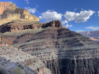
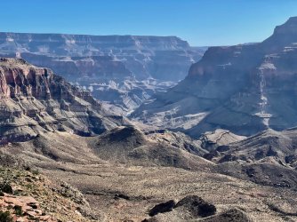
After Monument Point, we headed down. In this picture, you can see the smoke to the southeast.

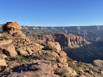
Lots of big views lay before us. As always, I took way too many photos and tried to narrow them down to share. There are still way too many...

When planning the trip, I had read lots of reports and watched lots of youtube videos. For the oft-discussed obstacle on the way down, I knew that some people took packs off and some kept them on. We did packs off for the first part and kept them on for the little part below that.

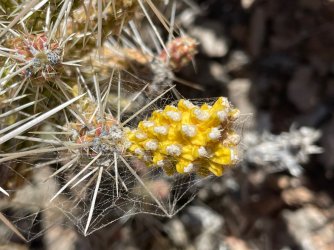
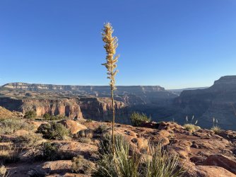
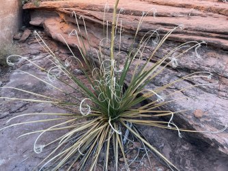
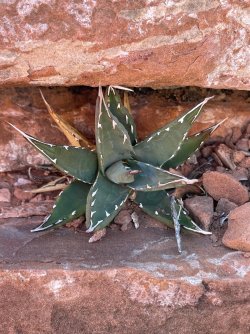
I was pleasantly surprised by how many interesting plants, flowers, and seed pods we saw. I had incorrectly assumed that on a late October trip we wouldn't see much. These are some of the ones I enjoyed on our way down from Monument Point to the Esplanade.


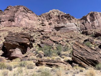
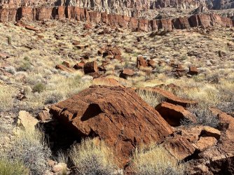
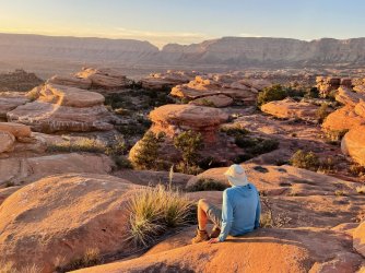
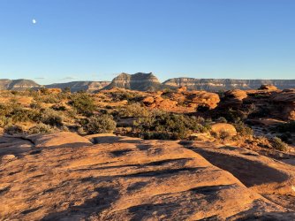
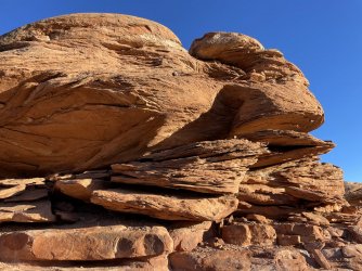
I knew ahead of time that the Esplanade had rock formations similar to Canyonlands' Needles. After being there half a year ago, I was delighted to see the Grand Canyon meet the Needles. So fun!


I loved looking back at where we had come from and seeing everything from different angles. Here you can see Bridger's Knoll on the right and whatever it's called on the left that we had descended.

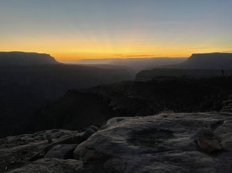
Walking on the Esplanade was easy and fun. We got to the edge and picked a great spot to camp for the night. Before the early darkness arrived, we had time to set up, cache our water (blocked by the rocks in the hole) eat, explore, and enjoy the gorgeous colors at sunset.


The first quarter moon was beautiful - very bright in the clear sky, and it lit up the rocks and canyon walls. To sleep, we had to turn away or cover our eyes. But eventually it went down and when I awoke throughout the night I would put on my glasses and stare. It was fun to watch Orion chase Jupiter across the sky. The Orionid Meteor Shower made the fabulous sky viewing even better. I don't have a fancy camera - just a phone - but enjoyed taking a few nighttime shots.


Day 2 - Esplanade to Deer Creek, Patio, and Falls
Early morning was stunning. While I was still lying down, I enjoyed watching the stars gradually disappear until only Venus was left. Then the sun took over!


Hiking down the Redwall was fun, and temps in Surprise Valley were just right. I delighted in seeing lots of interesting plants and rocks. If I weren't a born-teacher and were to pick a late-life profession, it would probably be geologist or cactiologist (is there such a thing?). But instead, I just enjoyed the rocks and plants and wondered about them without knowing many details. I'm ok with that!


As we approached Deer Creek, we had some fun spots to walk - very carefully - and loved the "Throne Room" with its fabulous cool, shady alcove and chunks of rocks that had fallen from above who-knows-how-many years ago. We didn't see the datura (nightshade) blooming, but I loved the spiky seed pods.


Deer Creek is lined with beautiful trees and plants. Such an oasis in that rocky desert space!


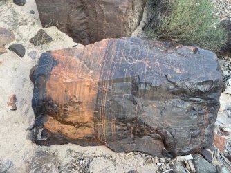
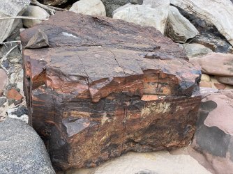
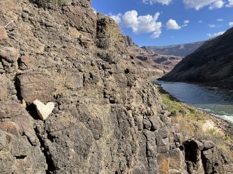
After setting up camp at Deer Creek, we headed to the Patio and marveled at its sculpted walls. The ledgy spots were ok for some but not others; one in our group turned back rather than pass the final challenging spot. Two of us went down to the falls, and I couldn't believe how powerful that water was, especially since there's typically more in the spring. The spray pushed me backward! I loved seeing the Colorado close up, with its rafts pulled in for the evening. I also loved seeing the "basement" rocks. Fantastic!


We returned to camp in time to see the last bit of rock being lit up by the sun.

Again, we slept without a tent and I enjoyed the nighttime show tremendously. Here's the light of the moon reflected in Deer Creek.

Day 3 - Deer Creek to Upper Tapeats
In the morning, it was fun to see this flower blooming near our camp that had not been blooming the afternoon before.

We decided to enjoy the Patio a little more before heading up and away from Deer Creek. This time on the Patio we crossed and enjoyed the scenes from the other (east) side.


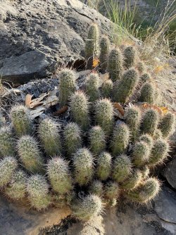
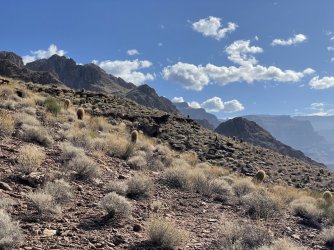
As we ascended above Deer Creek, I loved seeing all the cacti, as well as looking back at Deer Creek - so much green there!


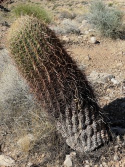
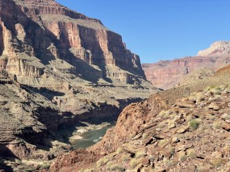
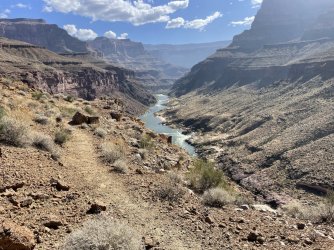
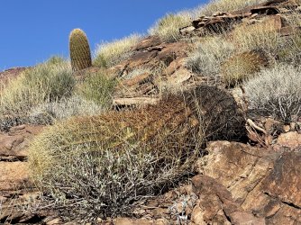
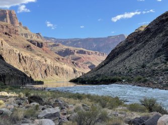
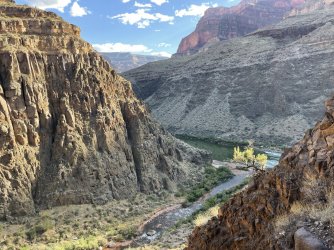
Ahead of time, we had decided we'd traverse above the river along the upper route. We probably could have managed the super ledgy spot on the lower route, but the less risky option would be less stressful. Our route had plenty of interesting spots, but nothing problematic. It was beautiful, with the river visible on and off down below and lots of fabulous rocks and cacti to enjoy that were lit up by the sun. I delighted in seeing the different stages of the barrel (I think?) cacti - some young and small, some tall and straight, some leaning over, and some leaning over so far that they ended up lying on the ground. And all those great rocks!


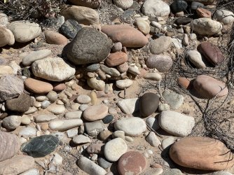
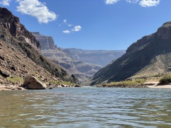
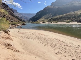
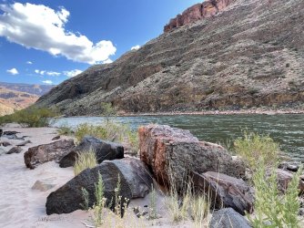
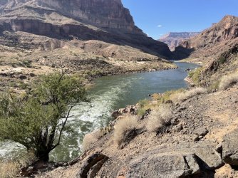
It was exciting to get down to the river. Some of the stones there were much smoother and rounder than the jagged ones they originally fell from higher up who-knows-how-long-ago. We enjoyed the sandy beach and were happy to cool off in a calm part of the river. I rarely crave opportunities to swim on backpacking trips (too cold usually), but this time I was determined to get in that water and had a great time!")


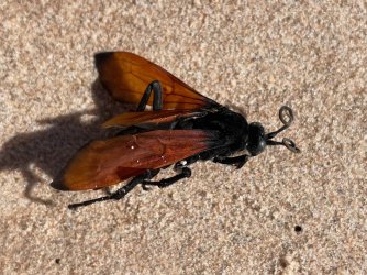
Dead tarantula wasp on the beach - I'm really glad it wasn't alive and interested in stinging us!

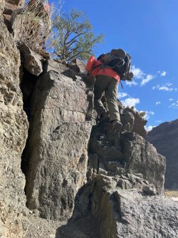
After enjoying the water, we dried off (20 seconds maybe???) and continued on toward Tapeats Creek. The challenging part at Bonita Creek was ok since we were going up (longer legs would have been helpful, though). I think going down would have been much harder, and we were glad to have done the route counter-clockwise. Actually, there were multiple times on the trip where we thought the clockwise route would have been harder (risk-wise) and it's interesting to me that it's the more common direction. I wonder why? I guess there are lots of daredevils out there (including BCP members, I'm sure) who enjoy the thrill of greater risk. Not us! Anyway, here's a photo going up at Bonita Creek, then a photo looking down once we got up the scramble, then some other photos between there and Tapeats. So many great rocks and river views!


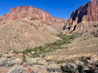
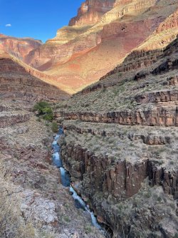
We headed up magnificent Tapeats Canyon. The canyon walls surrounding us were stunning, and the rapids down below were remarkable. I had watched a youtube video of guys kayaking down Tapeats. Wow!


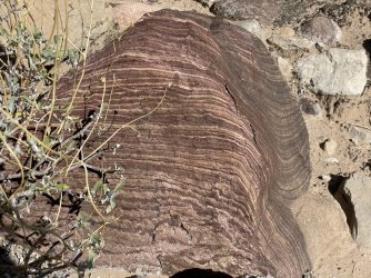
This rock looked like a Grand Canyon version of those layered petits four desserts.

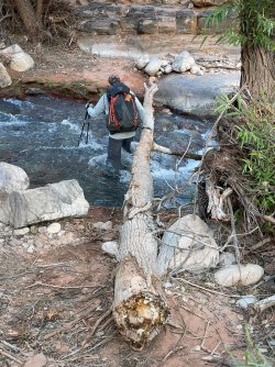
Pretty soon it was time for the first Tapeats Creek crossing. We didn't want to do the ledgy west side (that's a constant theme, right?). So that required us to cross the creek. BUT years earlier I had heard about the Merrell family deaths crossing Tapeats (grandmother and grandson) and had thought I'd never do this trip. But my husband is persuasive... So then I was willing to do the trip but only in the fall, when there would be less water than in the spring. Well, the time had come. Earlier that day, we had heard that the creek was flowing fast and strong but would be ok. The first crossing had a wonderful log that you could hold onto if necessary. It was a great security blanket for me, and I had no trouble. I commented that I was glad for the log and couldn't imagine crossing without it...

After the first crossing, there was lots more great scenery plus lots of fun scrambles - up and down over and over again. Our pace was slow, and we knew that sunset was getting closer. Maybe we shouldn't have spent so long at the river? But it was so much fun and so worth it!


Such an enormous old cottonwood - with fungi growing on it! (Fungi in the desert??? When you're next to a creek, maybe so!)

I loved this miniature pineapple (cactus seed pod) - so cool!


More great scenes along Tapeats


Eventually, it was time for the second creek crossing - to get back to the west side where our campsite would be. BUT there was no log. Oh no. The water of course was just as fast and strong here as before. I started getting nervous. Rob went first and did fine. Then my husband, who normally is more concerned about this sort of thing than I am. They both did fine. But they're taller. And I kept picturing the Merrell family. Andy came back over and took my pack. He offered to guide me across. Normally I'd say no. This time I said yes. I got to the other side and then burst into tears of relief. "I kept picturing the grandmother and grandson being swept away," I sobbed. "That wasn't a good idea." "I know, but I couldn't help it." Ugh. What a relief for me to be done with that Type 2.5 fun...
We got into camp, and by the time we ate dinner, it was dark. Guess who wanted to join our dinner party? MICE ! At least 3 of them were all over the place, crawling on my husband's leg, crawling on the Ratsack hanging nearby (in the future, we won't bother hanging them). Even though they'd probably go away once we finished eating, I wanted to sleep in the tent. That was the only night we used the tent. No rainfly, though, so I still had great sky views. Canyon walls were sooooo lit up by the moon! As with the other nights, once the moon went down, the stars, planets, and shooting stars put on a great show.
Day 4 - Upper Tapeats to Esplanade
What a great day yesterday had been - so many interesting, varied spots to spend time in. On this day, we were excited to see Thunder River. Pictures and videos don't do justice to all that water gushing out of the cliff. And there was so much lush green life there! I loved the beautiful red flowers (scarlet monkeyflower or something similar) next to the water. It was hot down there, and we were happy to wet our shirts before starting the big uphill to Surprise Valley. We loved seeing Tapeats Canyon continue past the confluence with Thunder River. Magnificent!


 .
. 


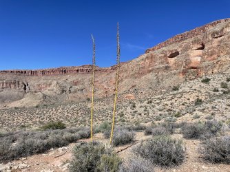
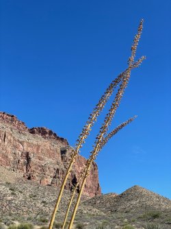
Back up in Surprise Valley, I loved all the agave plants (double, triple, silver & gold).


Loved these cactus seed pods!

How are we ever going to get up the Redwall? And how in the world did the first people make the trail?!


 .
.
But we did make it up, a lot more easily than I expected, actually.
Back on the Esplanade, we found our cached water, patiently waiting for us. That was the first time we had ever stored water, and I'm glad it went smoothly.
We were treated to lots more great scenes, especially in the golden late afternoon light. We went exploring and enjoyed all the great rocks, as well as fun plants like the tiny agave.


Day 5 - Esplanade back to our car - sad to be finished
The sky on our final morning was spectacular. I watched and took photos for over an hour. My sweet husband didn't give me a hard time and did extra packing up that day.


In this shot, I couldn't get my legs out of the picture, so I decided to pose.

And here's the icing on the cake (I guess it would have to be a layer cake, right?) - On Day 1, we had heard that a California Condor had been sighted somewhere in the Deer Creek area. We had been lucky enough to see several condors a year and a half ago, wayyyyy upstream in the Vermillion Cliffs. So every once in a while on this trip, I would say, "I vote for seeing a condor." Now, really, what was the likelihood of that? Well, I guess my vote counted after all and sure enough, when we were almost packed up I looked up and said, "Hey, do you think that's a condor?" Indeed, it was - we zoomed in and compared it to other pictures. Thrilling! The photo isn't great, but I've got one nonetheless.

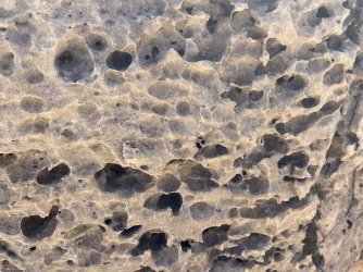
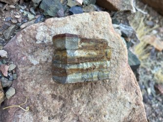
The rest of the morning was a lovely recap of Day 1 - heading up to the trailhead, looking back and forth ahead and behind us, enjoying again the expanses of crypto and various plants we hadn't seen since our first day, seeing new things like a fossil. It's always exciting to finish a backpacking trip, but I was sad to have this one end.


I guess it was fitting that one of the last things I photographed were oak leaves. The trees would be beautiful back at home...

Travel Day - fly to Vegas, drive to Kanab
Even before we arrived at the Grand Canyon, the trip was off to a great start. When flying, I love getting a window seat and looking down below when the skies are clear. Luck was with me, for as we flew near the Vermillion Cliffs I was on the correct side of the plane to see some of my favorite spots from previous trips: Coyote Buttes North (The Wave), Coyote Buttes South, Buckskin Gulch, etc. I was thrilled to capture this image:
Once we landed, we enjoyed beautiful scenery on our drive to Kanab, had a great dinner, and got our packs ready for the morning. As usual, I had a mix of emotions before starting a big trip: excited and nervous. A lot of anticipation had built up over many months - researching the route, deciding to hike counter-clockwise, filling out a permit request, getting everything we had requested, doing more research, and planning, planning, planning. How would my knees do? What would it be like carrying all that water on Day 1 (5 liters plus an extra gallon to cache for our final night)? Would the cache be waiting for us at the end? Would I manage the big uphill? What about the Tapeats crossing? etc etc etc. I couldn't believe the trip was finally upon us!
Day 1 - Bill Hall TH to Esplanade
We left our hotel in Kanab and loved the drive to the trailhead. It was fascinating to go through so many different plant/tree zones. At a few points along the way, there was heavy smoke from prescribed burns. We wondered if it would affect us while backpacking. (Fortunately it didn't end up being a problem, perhaps because the heavy winds on Day 1 blew it away.) We got to our trailhead, chatted with some people who had just finished, and got started. This is a well-trafficked route, but because of the permitting process we knew it wouldn't be too crowded - at least not for us; I realize others prefer greater solitude. For this route, you first go up to Monument Point. Here's a photo looking back toward our car:
After Monument Point, we headed down. In this picture, you can see the smoke to the southeast.
Lots of big views lay before us. As always, I took way too many photos and tried to narrow them down to share. There are still way too many...
When planning the trip, I had read lots of reports and watched lots of youtube videos. For the oft-discussed obstacle on the way down, I knew that some people took packs off and some kept them on. We did packs off for the first part and kept them on for the little part below that.
I was pleasantly surprised by how many interesting plants, flowers, and seed pods we saw. I had incorrectly assumed that on a late October trip we wouldn't see much. These are some of the ones I enjoyed on our way down from Monument Point to the Esplanade.
I knew ahead of time that the Esplanade had rock formations similar to Canyonlands' Needles. After being there half a year ago, I was delighted to see the Grand Canyon meet the Needles. So fun!
I loved looking back at where we had come from and seeing everything from different angles. Here you can see Bridger's Knoll on the right and whatever it's called on the left that we had descended.
Walking on the Esplanade was easy and fun. We got to the edge and picked a great spot to camp for the night. Before the early darkness arrived, we had time to set up, cache our water (blocked by the rocks in the hole) eat, explore, and enjoy the gorgeous colors at sunset.
The first quarter moon was beautiful - very bright in the clear sky, and it lit up the rocks and canyon walls. To sleep, we had to turn away or cover our eyes. But eventually it went down and when I awoke throughout the night I would put on my glasses and stare. It was fun to watch Orion chase Jupiter across the sky. The Orionid Meteor Shower made the fabulous sky viewing even better. I don't have a fancy camera - just a phone - but enjoyed taking a few nighttime shots.
Day 2 - Esplanade to Deer Creek, Patio, and Falls
Early morning was stunning. While I was still lying down, I enjoyed watching the stars gradually disappear until only Venus was left. Then the sun took over!
Hiking down the Redwall was fun, and temps in Surprise Valley were just right. I delighted in seeing lots of interesting plants and rocks. If I weren't a born-teacher and were to pick a late-life profession, it would probably be geologist or cactiologist (is there such a thing?). But instead, I just enjoyed the rocks and plants and wondered about them without knowing many details. I'm ok with that!
As we approached Deer Creek, we had some fun spots to walk - very carefully - and loved the "Throne Room" with its fabulous cool, shady alcove and chunks of rocks that had fallen from above who-knows-how-many years ago. We didn't see the datura (nightshade) blooming, but I loved the spiky seed pods.
Deer Creek is lined with beautiful trees and plants. Such an oasis in that rocky desert space!
After setting up camp at Deer Creek, we headed to the Patio and marveled at its sculpted walls. The ledgy spots were ok for some but not others; one in our group turned back rather than pass the final challenging spot. Two of us went down to the falls, and I couldn't believe how powerful that water was, especially since there's typically more in the spring. The spray pushed me backward! I loved seeing the Colorado close up, with its rafts pulled in for the evening. I also loved seeing the "basement" rocks. Fantastic!
We returned to camp in time to see the last bit of rock being lit up by the sun.
Again, we slept without a tent and I enjoyed the nighttime show tremendously. Here's the light of the moon reflected in Deer Creek.
Day 3 - Deer Creek to Upper Tapeats
In the morning, it was fun to see this flower blooming near our camp that had not been blooming the afternoon before.
We decided to enjoy the Patio a little more before heading up and away from Deer Creek. This time on the Patio we crossed and enjoyed the scenes from the other (east) side.
As we ascended above Deer Creek, I loved seeing all the cacti, as well as looking back at Deer Creek - so much green there!
Ahead of time, we had decided we'd traverse above the river along the upper route. We probably could have managed the super ledgy spot on the lower route, but the less risky option would be less stressful. Our route had plenty of interesting spots, but nothing problematic. It was beautiful, with the river visible on and off down below and lots of fabulous rocks and cacti to enjoy that were lit up by the sun. I delighted in seeing the different stages of the barrel (I think?) cacti - some young and small, some tall and straight, some leaning over, and some leaning over so far that they ended up lying on the ground. And all those great rocks!
It was exciting to get down to the river. Some of the stones there were much smoother and rounder than the jagged ones they originally fell from higher up who-knows-how-long-ago. We enjoyed the sandy beach and were happy to cool off in a calm part of the river. I rarely crave opportunities to swim on backpacking trips (too cold usually), but this time I was determined to get in that water and had a great time!
Dead tarantula wasp on the beach - I'm really glad it wasn't alive and interested in stinging us!
After enjoying the water, we dried off (20 seconds maybe???) and continued on toward Tapeats Creek. The challenging part at Bonita Creek was ok since we were going up (longer legs would have been helpful, though). I think going down would have been much harder, and we were glad to have done the route counter-clockwise. Actually, there were multiple times on the trip where we thought the clockwise route would have been harder (risk-wise) and it's interesting to me that it's the more common direction. I wonder why? I guess there are lots of daredevils out there (including BCP members, I'm sure) who enjoy the thrill of greater risk. Not us! Anyway, here's a photo going up at Bonita Creek, then a photo looking down once we got up the scramble, then some other photos between there and Tapeats. So many great rocks and river views!
We headed up magnificent Tapeats Canyon. The canyon walls surrounding us were stunning, and the rapids down below were remarkable. I had watched a youtube video of guys kayaking down Tapeats. Wow!
This rock looked like a Grand Canyon version of those layered petits four desserts.
Pretty soon it was time for the first Tapeats Creek crossing. We didn't want to do the ledgy west side (that's a constant theme, right?). So that required us to cross the creek. BUT years earlier I had heard about the Merrell family deaths crossing Tapeats (grandmother and grandson) and had thought I'd never do this trip. But my husband is persuasive... So then I was willing to do the trip but only in the fall, when there would be less water than in the spring. Well, the time had come. Earlier that day, we had heard that the creek was flowing fast and strong but would be ok. The first crossing had a wonderful log that you could hold onto if necessary. It was a great security blanket for me, and I had no trouble. I commented that I was glad for the log and couldn't imagine crossing without it...
After the first crossing, there was lots more great scenery plus lots of fun scrambles - up and down over and over again. Our pace was slow, and we knew that sunset was getting closer. Maybe we shouldn't have spent so long at the river? But it was so much fun and so worth it!
Such an enormous old cottonwood - with fungi growing on it! (Fungi in the desert??? When you're next to a creek, maybe so!)
I loved this miniature pineapple (cactus seed pod) - so cool!
More great scenes along Tapeats
Eventually, it was time for the second creek crossing - to get back to the west side where our campsite would be. BUT there was no log. Oh no. The water of course was just as fast and strong here as before. I started getting nervous. Rob went first and did fine. Then my husband, who normally is more concerned about this sort of thing than I am. They both did fine. But they're taller. And I kept picturing the Merrell family. Andy came back over and took my pack. He offered to guide me across. Normally I'd say no. This time I said yes. I got to the other side and then burst into tears of relief. "I kept picturing the grandmother and grandson being swept away," I sobbed. "That wasn't a good idea." "I know, but I couldn't help it." Ugh. What a relief for me to be done with that Type 2.5 fun...
We got into camp, and by the time we ate dinner, it was dark. Guess who wanted to join our dinner party? MICE ! At least 3 of them were all over the place, crawling on my husband's leg, crawling on the Ratsack hanging nearby (in the future, we won't bother hanging them). Even though they'd probably go away once we finished eating, I wanted to sleep in the tent. That was the only night we used the tent. No rainfly, though, so I still had great sky views. Canyon walls were sooooo lit up by the moon! As with the other nights, once the moon went down, the stars, planets, and shooting stars put on a great show.
Day 4 - Upper Tapeats to Esplanade
What a great day yesterday had been - so many interesting, varied spots to spend time in. On this day, we were excited to see Thunder River. Pictures and videos don't do justice to all that water gushing out of the cliff. And there was so much lush green life there! I loved the beautiful red flowers (scarlet monkeyflower or something similar) next to the water. It was hot down there, and we were happy to wet our shirts before starting the big uphill to Surprise Valley. We loved seeing Tapeats Canyon continue past the confluence with Thunder River. Magnificent!
. Back up in Surprise Valley, I loved all the agave plants (double, triple, silver & gold).
Loved these cactus seed pods!
How are we ever going to get up the Redwall? And how in the world did the first people make the trail?!
.But we did make it up, a lot more easily than I expected, actually.
Back on the Esplanade, we found our cached water, patiently waiting for us. That was the first time we had ever stored water, and I'm glad it went smoothly.
We were treated to lots more great scenes, especially in the golden late afternoon light. We went exploring and enjoyed all the great rocks, as well as fun plants like the tiny agave.
Day 5 - Esplanade back to our car - sad to be finished
The sky on our final morning was spectacular. I watched and took photos for over an hour. My sweet husband didn't give me a hard time and did extra packing up that day.
In this shot, I couldn't get my legs out of the picture, so I decided to pose.
And here's the icing on the cake (I guess it would have to be a layer cake, right?) - On Day 1, we had heard that a California Condor had been sighted somewhere in the Deer Creek area. We had been lucky enough to see several condors a year and a half ago, wayyyyy upstream in the Vermillion Cliffs. So every once in a while on this trip, I would say, "I vote for seeing a condor." Now, really, what was the likelihood of that? Well, I guess my vote counted after all
and sure enough, when we were almost packed up I looked up and said, "Hey, do you think that's a condor?" Indeed, it was - we zoomed in and compared it to other pictures. Thrilling! The photo isn't great, but I've got one nonetheless.The rest of the morning was a lovely recap of Day 1 - heading up to the trailhead, looking back and forth ahead and behind us, enjoying again the expanses of crypto and various plants we hadn't seen since our first day, seeing new things like a fossil. It's always exciting to finish a backpacking trip, but I was sad to have this one end.
I guess it was fitting that one of the last things I photographed were oak leaves. The trees would be beautiful back at home...
Attachments
-
 IMG_9168.jpg811.9 KB · Views: 2
 -
 IMG_9231.jpg756.4 KB · Views: 2
 -
 IMG_9390.jpg713.1 KB · Views: 2
 -
 IMG_9398.jpg726.1 KB · Views: 2
 -
 IMG_9392.jpg726 KB · Views: 1
 -
 IMG_9331.jpg757.9 KB · Views: 1
 -
 IMG_9323.jpg919.9 KB · Views: 1
 -
 IMG_9321.jpg556.8 KB · Views: 1
 -
 IMG_9315.jpg903.4 KB · Views: 1
 -
 IMG_9276.jpg851.9 KB · Views: 1
 -
 IMG_9271.jpg878.2 KB · Views: 1
 -
 IMG_9262.jpg666.3 KB · Views: 1
 -
 IMG_9248.jpg573.8 KB · Views: 1
 -
 IMG_9231.jpg756.4 KB · Views: 0
 -
 IMG_9168.jpg811.9 KB · Views: 0
 -
 IMG_9390.jpg713.1 KB · Views: 0
 -
 IMG_9398.jpg726.1 KB · Views: 0
 -
 IMG_9392.jpg726 KB · Views: 1
 -
 IMG_9331.jpg757.9 KB · Views: 1
 -
 IMG_9323.jpg919.9 KB · Views: 1
 -
 IMG_9321.jpg556.8 KB · Views: 0
 -
 IMG_9315.jpg903.4 KB · Views: 0
 -
 IMG_9276.jpg851.9 KB · Views: 0
 -
 IMG_9271.jpg878.2 KB · Views: 0
 -
 IMG_9262.jpg666.3 KB · Views: 0
 -
 IMG_9248.jpg573.8 KB · Views: 0
 -
 IMG_9440.jpg461.6 KB · Views: 0
 -
 IMG_9411.jpg437.6 KB · Views: 0
 -
 IMG_9399.jpg448.5 KB · Views: 0
 -
 IMG_9533.jpg503.1 KB · Views: 0
 -
 IMG_9531.jpg417 KB · Views: 0
 -
 IMG_9529.jpg614.3 KB · Views: 0
 -
 IMG_9528.jpg660.8 KB · Views: 0
 -
 IMG_9509.jpg815.5 KB · Views: 0
 -
 IMG_9498.jpg720.1 KB · Views: 0
 -
 IMG_9476.jpg617.1 KB · Views: 0
 -
 IMG_9598.jpg651.7 KB · Views: 0
 -
 IMG_9558.jpg419 KB · Views: 0
 -
 IMG_9562.jpg554.7 KB · Views: 0
 -
 IMG_9540.jpg653 KB · Views: 0
 -
 IMG_9607.jpg790.7 KB · Views: 0
 -
 IMG_9607.jpg790.7 KB · Views: 0
 -
 IMG_9168.jpg811.9 KB · Views: 0
 -
 IMG_9231.jpg756.4 KB · Views: 0
 -
 IMG_9231.jpg756.4 KB · Views: 0
 -
 IMG_9168.jpg811.9 KB · Views: 0
 -
 IMG_0018.jpg729.6 KB · Views: 0
 -
 IMG_0023.jpg341.2 KB · Views: 0
 -
 IMG_9985.jpg668.5 KB · Views: 0
 -
 IMG_9996.jpg377.3 KB · Views: 0
 -
 IMG_0202.jpg245.8 KB · Views: 0
 -
 IMG_0156.jpg510.9 KB · Views: 0
 -
 IMG_0151.jpg470.8 KB · Views: 0
 -
 IMG_0115.jpg416.1 KB · Views: 0
 -
 IMG_0109.jpg521.8 KB · Views: 0
 -
 IMG_0078.jpg633.7 KB · Views: 0
 -
 IMG_0064.jpg493.2 KB · Views: 0
 -
 IMG_0100.jpg477.9 KB · Views: 0
 -
 IMG_0057.jpg585.6 KB · Views: 2
Last edited: