- Joined
- Oct 30, 2016
- Messages
- 942
Trip reports from the baby 'mountains' out east welcome? Feel free to move/nuke if not ") .
.
---------
I'd been looking forward to a 5 day solo trip on Isle Royale for two months, only to watch with growing disappointment as a freakishly wet September culminated in a forecast of 3+ inches of rain for the first two days of my visit and a steady soaking for most of the rest. I don't mind a bit of rain, but hunkered down in a tent on an island in the midwest for days on end didn't seem like the best use of precious vacation time, so I needed to put together a plan B. The only two spots within a day's drive that had more sun than rain in the forecast were Red River Gorge or the Smoky's. I'd been to RRG climbing recently, but hadn't been to the Smoky's since I was a kid.
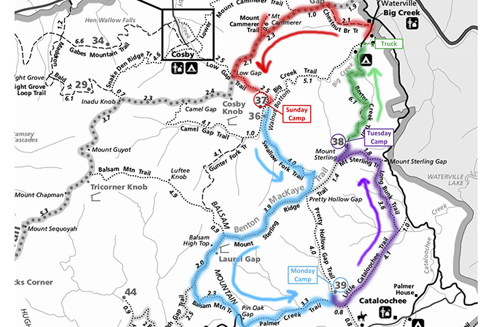
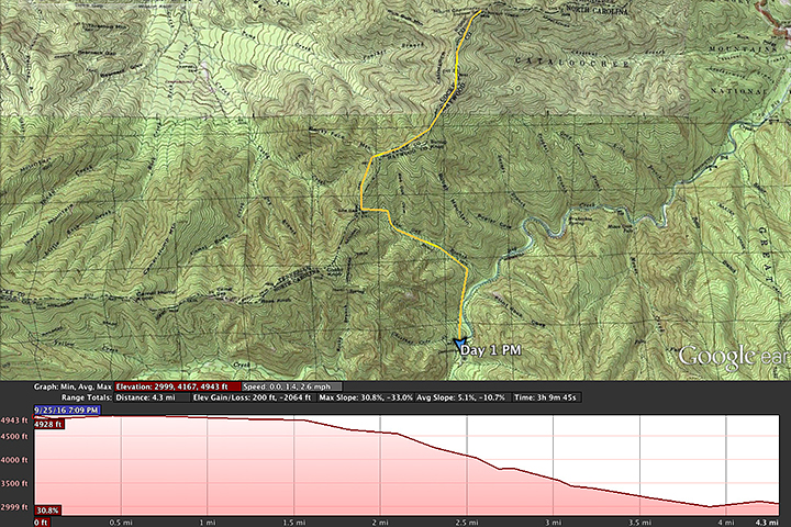
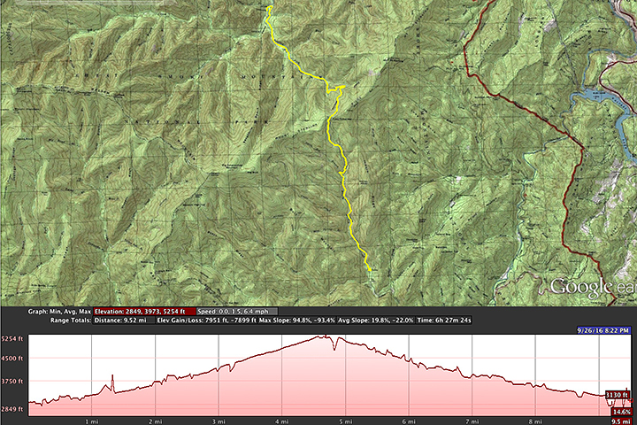
Permits proved surprisingly easy to snag, with a lot of vacancies across all the designated camp sites and shelters. Putting together a loop that worked with the camp site layout was more challenging, but ultimately I decided on a 4 day 3 night trip:
I started hiking around 10:00a. Didn't get much sleep the night before, but I was excited and looking forward to the trip. With camera/video gear and other non-essentials I was again playing the mule, walking in with 45 pounds. It was already humid, with a forecasted high of 92. I was hoping that things would be a bit more mild up top.
Chestnut Branch trail is pretty much a straight shot up for two miles to the Appalachian Trail, picking up a couple thousand feet of elevation along the way. From there I'd climb another 2000 or so to Mt Cammerer. I passed a few people heading down, and leap frogged my way up with a younger couple headed for the same camp site that night. The forest was dense and the humidity oppressive. Within half a mile I'd zipped off the legs of my pants and was sweating profusely.
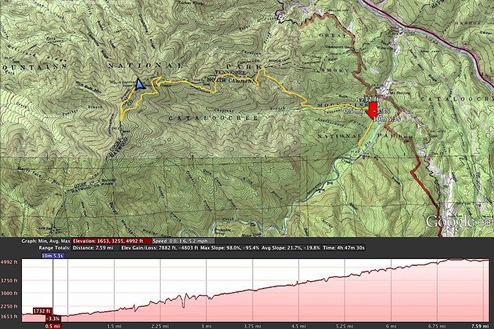
After a couple of hours I turned west on to the AT. I'd been warned that it had been a dry summer and that water in the upper elevations was scarce so I topped off as I hiked, but once I hit the AT it would be another 7-8 miles before I saw more than a patch of drying mud. I can not overstate how much I had been sweating and would continue to sweat for the entire hike. Clothes absolutely soaked through. The humidity trapped in the trees (the 'smoke' of the Smoky Mountains) pretty much guaranteeing nothing was going to be drying out any time soon.
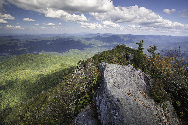
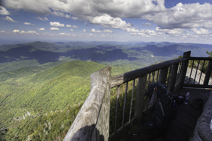
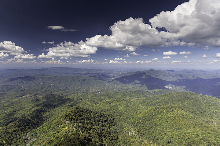
Two hours and a another couple thousand feet higher, I reached the fire tower at Mt Cammerer and took a break. Great vantage point with 360 degrees of rolling hills receding in shades of blues and grays. Lunch was trail mix, and some turkey sausage sticks. Not really hungry. I was a bit worried about my water supply, but confident that I'd be able to refill "real soon" as I started to hike down the mountain towards camp. I drank what I felt I could spare, saving myself half a liter for the hike.
As storm clouds moved in from the west I climbed back down to the AT and started the 4mi hike to camp. Back on the AT I ran in to the couple I'd been seeing throughout the morning. They were clearly wrecked, one looked like there had been some tears, and they said they were skipping the visit to the tower and just heading for camp because they'd run out of water. I commiserated for a minute and then headed off.
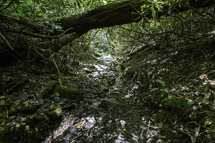
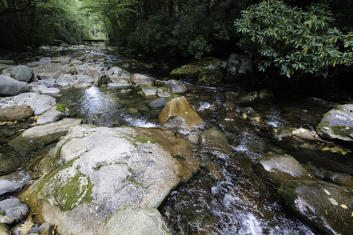
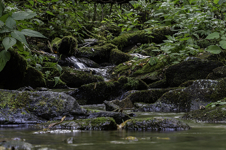
The rest of the day's hike was largely uneventful. I'd pass the occasional hiker and ask if they'd seen any water sources, then move on after they'd inevitably say they hadn't. I was tapping an empty water bottle against my leg after half an hour or so. Half way down I headed south on the Low Gap trail, in to the darkest section of forest of the trip so far. Beautiful woods that reminded me a lot of jungle - large snaking vines climbing the trees, ferns lining the trails, a thick canopy far above and the echoes of unseen birds all around.
Finally I came upon a trickle of a creek and started filtering and guzzling. The leapfrog couple arrived as I was finishing up, and I'd see them for the last time as they were setting up camp later in the evening.
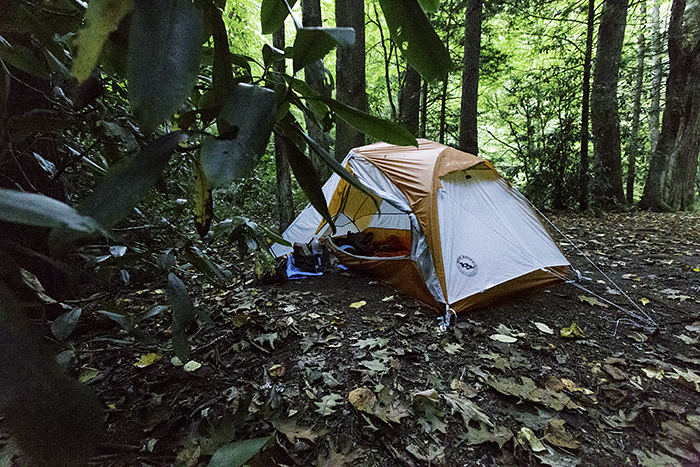
Soon enough I reached the night's camp - Lower Walnut Bottom, camp site #37. Four other sites with folks in them. Not a lot of time to mess around before dark as the sun was already low behind the hills. Forced down the rest of the day's allotment of trail mix and a chocolate square for dinner, with neither desire nor appetite to bother with a mountain house. Got camp set up, bag on the bear cable, clothes rinsed in the creek and then I crashed in my tent. Apart from waking to the periodic blasting of my tent by neighboring headlamps, I pretty much stayed asleep till a bit before sunrise.
Day two - well rested and feeling great. Oatmeal and coffee for breakfast. A clean and dry shirt and underwear. Didn't feel quite as humid out. Today was going to be a bit of a longer hike so I packed up and headed back out on the trail. First 4 miles was another climb of about 2500 feet up to the Benton McKaye trail, after which I could either take a long westward loop over Balsam Mountain or take a direct route down Pretty Hollow Gap trail to the next camp. I figured I'd play it by ear, with the decision to be made after the morning's climb and based on wanting to have a little free time at camp before nightfall.
I called this section of the hike Bear Scat Trail. The Park has a thriving population of black bears to (says their literature) the tune of two bears per square mile. The amount of scat on the trail was... impressive. There was a fresh, wet pile to be admired every five or ten minutes. I hadn't seen any bears and, after listening to the sound of something large crashing away from me in the woods a couple of times, I assumed that my sweaty stink was probably an excellent bear repellent.
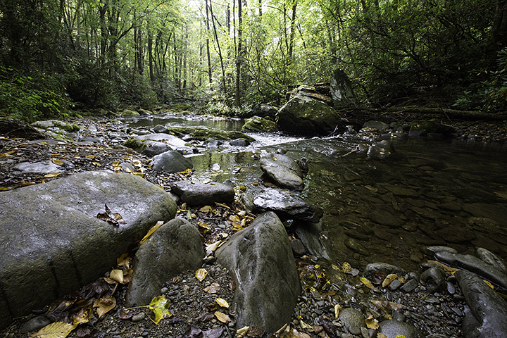
Great morning hike. Lots of stops to take pics along the way. It started to get warm again but there were numerous creeks to be crossed so water was plentiful. I took full advantage. I'd downed 2-3 liters at camp, and was drinking like a sailor the entire morning, determined not to end up in the same situation as the day before. Drink, drink, drink. Sweat, sweat, sweat.
Before I knew it I was at the gap and it was time for lunch. More trail mix and a couple sausage sticks and not a lot of hunger again. Drank some more water. The gap is just this little opening in the trees where the sun shines down on the trail intersection. No views, just a pleasant little respite from the forest. Bugs though, and lots of them. Only real bugs the entire trip.
I decided based on the remaining miles and the time of day that I'd just take the straight route to camp so that I could arrive with ample time to get things set up and chill. The next 4 miles was a really pretty hike, though a bit jarring on the knees for the first mile or so until the slope smoothed out a bit. I hadn't seen another person since breaking camp in the morning and wouldn't until the following day.
Soon enough I got to camp site #39. This site was under Excessive Bear Activity Warning and, perhaps unsurprisingly, I had it all to myself. This had one big benefit - no one to offend as I marched off to a stretch of the nearby creek that was sheltered from the view of the trail and got buck naked to rinse off as best I could.
Thunder started banging away so I got camp set up. Other than a couple of spitters it was all show and no go so far. Still not much of an appetite so - you guessed it - rest of the trail mix and another chocolate square for dinner. Apparently I just carried a bunch of mountain house to N Carolina to pad out the pack. Bag on the cable, clothes on a line to dry for a while, and I cracked a book and relaxed till just before dark. Then it started drizzling for a short while, so I gathered everything up and holed up in the tent for another night.
Eventually the storm arrived. Just as I had started to doze I thought I heard wind blowing through the trees, but the sound never let up and just grew louder and louder until it came over the top of me and I realized it was the leading edge of the rain as it rolled through the forest. The rain kept up for the rest of the night.
In the middle of the night I woke up feeling... off. My stomach felt tight and I started getting the sickly saliva feeling that comes when nausea hits and you feel like you're about to throw up.
Pause here, and flash back 6 or 7 months earlier. It's mid afternoon on a Saturday at home when out of nowhere, with no warning at all, I feel... off. My stomach felt tight and I started getting the sickly saliva feeling that comes when nausea hits and you feel like you're about to throw up. I spend the next 8 hours vomiting and shitting so violently that at one point I blacked out on the toilet and crashed head first in to the floor, coming to with blood running down my face and my wife standing at the bathroom door absolutely losing her shit wondering if she was about to be a widow. When I wasn't in the bathroom I was lying in a fetal position on the bed, every fiber of muscle in my body cramping so hard I thought my bones would break. Completely incapacitated until it all just - went away.
Present day. It's 2am in the Smoky Mountains and hey I remember feeling this way once before and - wait a minute I'm the only one in this camp - shit, excessive bear activity - oh my god i've been eating nothing but trail mix and chocolate for days! IM GOING TO START BARFING AND CRAPPING CHOCOLATE TRAIL MIX PUDDING AND THE BEARS ARE GOING TO CHARGE IN AND ILL BE LAYING HERE IN A FULL BODY CRAMP - CHRIST WHERES THE SOS BUTTON!
and then it went away and I went back to sleep till morning...
Day 3. Up and about, shake the rain off the fly, happy to see the backpack isn't too wet. Whoahhhhh, almost felt like I could have tossed my cookies there for a second. Better have some breakfast. Oatmeal. Coffee. Bit of water. Hmm, there's that feeling again. I'll just sit here a bit. Ugh, and again - am I going to puke or not wtf.
Repeat for two hours. Something was wrong so I had a decision to make. It was another 8 miles or so to the next camp site, the one I'd really been looking forward to at the fire tower atop Mt Sterling. Roll the dice and climb another mountain, hoping whatever I was feeling wouldn't make me part of yet another 'dumbass hiker carried out of national park' story? Or hit the eject button now, hike a couple miles down to a ranger station and see if I could get a ride back to my truck.
In the end I went with the early exit and after a pleasant visit with some park volunteers and an expensive cab ride back up to the Mill Creek park entrance, I was in my truck and on the way back to the hotel a day early. Two gatorades and two packets of ritz crackers with cheese-like filling and I was feeling 99% normal again. A healthy amount of beer that night got me the last 1%
If you're like me and like to short yourself on sleep at night by staying up watching overly long backpacking vids, there's a recording of this trip here:
.---------
I'd been looking forward to a 5 day solo trip on Isle Royale for two months, only to watch with growing disappointment as a freakishly wet September culminated in a forecast of 3+ inches of rain for the first two days of my visit and a steady soaking for most of the rest. I don't mind a bit of rain, but hunkered down in a tent on an island in the midwest for days on end didn't seem like the best use of precious vacation time, so I needed to put together a plan B. The only two spots within a day's drive that had more sun than rain in the forecast were Red River Gorge or the Smoky's. I'd been to RRG climbing recently, but hadn't been to the Smoky's since I was a kid.
Permits proved surprisingly easy to snag, with a lot of vacancies across all the designated camp sites and shelters. Putting together a loop that worked with the camp site layout was more challenging, but ultimately I decided on a 4 day 3 night trip:
I started hiking around 10:00a. Didn't get much sleep the night before, but I was excited and looking forward to the trip. With camera/video gear and other non-essentials I was again playing the mule, walking in with 45 pounds. It was already humid, with a forecasted high of 92. I was hoping that things would be a bit more mild up top.
Chestnut Branch trail is pretty much a straight shot up for two miles to the Appalachian Trail, picking up a couple thousand feet of elevation along the way. From there I'd climb another 2000 or so to Mt Cammerer. I passed a few people heading down, and leap frogged my way up with a younger couple headed for the same camp site that night. The forest was dense and the humidity oppressive. Within half a mile I'd zipped off the legs of my pants and was sweating profusely.
After a couple of hours I turned west on to the AT. I'd been warned that it had been a dry summer and that water in the upper elevations was scarce so I topped off as I hiked, but once I hit the AT it would be another 7-8 miles before I saw more than a patch of drying mud. I can not overstate how much I had been sweating and would continue to sweat for the entire hike. Clothes absolutely soaked through. The humidity trapped in the trees (the 'smoke' of the Smoky Mountains) pretty much guaranteeing nothing was going to be drying out any time soon.
Two hours and a another couple thousand feet higher, I reached the fire tower at Mt Cammerer and took a break. Great vantage point with 360 degrees of rolling hills receding in shades of blues and grays. Lunch was trail mix, and some turkey sausage sticks. Not really hungry. I was a bit worried about my water supply, but confident that I'd be able to refill "real soon" as I started to hike down the mountain towards camp. I drank what I felt I could spare, saving myself half a liter for the hike.
As storm clouds moved in from the west I climbed back down to the AT and started the 4mi hike to camp. Back on the AT I ran in to the couple I'd been seeing throughout the morning. They were clearly wrecked, one looked like there had been some tears, and they said they were skipping the visit to the tower and just heading for camp because they'd run out of water. I commiserated for a minute and then headed off.
The rest of the day's hike was largely uneventful. I'd pass the occasional hiker and ask if they'd seen any water sources, then move on after they'd inevitably say they hadn't. I was tapping an empty water bottle against my leg after half an hour or so. Half way down I headed south on the Low Gap trail, in to the darkest section of forest of the trip so far. Beautiful woods that reminded me a lot of jungle - large snaking vines climbing the trees, ferns lining the trails, a thick canopy far above and the echoes of unseen birds all around.
Finally I came upon a trickle of a creek and started filtering and guzzling. The leapfrog couple arrived as I was finishing up, and I'd see them for the last time as they were setting up camp later in the evening.
Soon enough I reached the night's camp - Lower Walnut Bottom, camp site #37. Four other sites with folks in them. Not a lot of time to mess around before dark as the sun was already low behind the hills. Forced down the rest of the day's allotment of trail mix and a chocolate square for dinner, with neither desire nor appetite to bother with a mountain house. Got camp set up, bag on the bear cable, clothes rinsed in the creek and then I crashed in my tent. Apart from waking to the periodic blasting of my tent by neighboring headlamps, I pretty much stayed asleep till a bit before sunrise.
Day two - well rested and feeling great. Oatmeal and coffee for breakfast. A clean and dry shirt and underwear. Didn't feel quite as humid out. Today was going to be a bit of a longer hike so I packed up and headed back out on the trail. First 4 miles was another climb of about 2500 feet up to the Benton McKaye trail, after which I could either take a long westward loop over Balsam Mountain or take a direct route down Pretty Hollow Gap trail to the next camp. I figured I'd play it by ear, with the decision to be made after the morning's climb and based on wanting to have a little free time at camp before nightfall.
I called this section of the hike Bear Scat Trail. The Park has a thriving population of black bears to (says their literature) the tune of two bears per square mile. The amount of scat on the trail was... impressive. There was a fresh, wet pile to be admired every five or ten minutes. I hadn't seen any bears and, after listening to the sound of something large crashing away from me in the woods a couple of times, I assumed that my sweaty stink was probably an excellent bear repellent.
Great morning hike. Lots of stops to take pics along the way. It started to get warm again but there were numerous creeks to be crossed so water was plentiful. I took full advantage. I'd downed 2-3 liters at camp, and was drinking like a sailor the entire morning, determined not to end up in the same situation as the day before. Drink, drink, drink. Sweat, sweat, sweat.
Before I knew it I was at the gap and it was time for lunch. More trail mix and a couple sausage sticks and not a lot of hunger again. Drank some more water. The gap is just this little opening in the trees where the sun shines down on the trail intersection. No views, just a pleasant little respite from the forest. Bugs though, and lots of them. Only real bugs the entire trip.
I decided based on the remaining miles and the time of day that I'd just take the straight route to camp so that I could arrive with ample time to get things set up and chill. The next 4 miles was a really pretty hike, though a bit jarring on the knees for the first mile or so until the slope smoothed out a bit. I hadn't seen another person since breaking camp in the morning and wouldn't until the following day.
Soon enough I got to camp site #39. This site was under Excessive Bear Activity Warning and, perhaps unsurprisingly, I had it all to myself. This had one big benefit - no one to offend as I marched off to a stretch of the nearby creek that was sheltered from the view of the trail and got buck naked to rinse off as best I could.
Thunder started banging away so I got camp set up. Other than a couple of spitters it was all show and no go so far. Still not much of an appetite so - you guessed it - rest of the trail mix and another chocolate square for dinner. Apparently I just carried a bunch of mountain house to N Carolina to pad out the pack. Bag on the cable, clothes on a line to dry for a while, and I cracked a book and relaxed till just before dark. Then it started drizzling for a short while, so I gathered everything up and holed up in the tent for another night.
Eventually the storm arrived. Just as I had started to doze I thought I heard wind blowing through the trees, but the sound never let up and just grew louder and louder until it came over the top of me and I realized it was the leading edge of the rain as it rolled through the forest. The rain kept up for the rest of the night.
In the middle of the night I woke up feeling... off. My stomach felt tight and I started getting the sickly saliva feeling that comes when nausea hits and you feel like you're about to throw up.
Pause here, and flash back 6 or 7 months earlier. It's mid afternoon on a Saturday at home when out of nowhere, with no warning at all, I feel... off. My stomach felt tight and I started getting the sickly saliva feeling that comes when nausea hits and you feel like you're about to throw up. I spend the next 8 hours vomiting and shitting so violently that at one point I blacked out on the toilet and crashed head first in to the floor, coming to with blood running down my face and my wife standing at the bathroom door absolutely losing her shit wondering if she was about to be a widow. When I wasn't in the bathroom I was lying in a fetal position on the bed, every fiber of muscle in my body cramping so hard I thought my bones would break. Completely incapacitated until it all just - went away.
Present day. It's 2am in the Smoky Mountains and hey I remember feeling this way once before and - wait a minute I'm the only one in this camp - shit, excessive bear activity - oh my god i've been eating nothing but trail mix and chocolate for days! IM GOING TO START BARFING AND CRAPPING CHOCOLATE TRAIL MIX PUDDING AND THE BEARS ARE GOING TO CHARGE IN AND ILL BE LAYING HERE IN A FULL BODY CRAMP - CHRIST WHERES THE SOS BUTTON!
and then it went away and I went back to sleep till morning...
Day 3. Up and about, shake the rain off the fly, happy to see the backpack isn't too wet. Whoahhhhh, almost felt like I could have tossed my cookies there for a second. Better have some breakfast. Oatmeal. Coffee. Bit of water. Hmm, there's that feeling again. I'll just sit here a bit. Ugh, and again - am I going to puke or not wtf.
Repeat for two hours. Something was wrong so I had a decision to make. It was another 8 miles or so to the next camp site, the one I'd really been looking forward to at the fire tower atop Mt Sterling. Roll the dice and climb another mountain, hoping whatever I was feeling wouldn't make me part of yet another 'dumbass hiker carried out of national park' story? Or hit the eject button now, hike a couple miles down to a ranger station and see if I could get a ride back to my truck.
In the end I went with the early exit and after a pleasant visit with some park volunteers and an expensive cab ride back up to the Mill Creek park entrance, I was in my truck and on the way back to the hotel a day early. Two gatorades and two packets of ritz crackers with cheese-like filling and I was feeling 99% normal again. A healthy amount of beer that night got me the last 1%
If you're like me and like to short yourself on sleep at night by staying up watching overly long backpacking vids, there's a recording of this trip here:
Last edited: