Dave John
Soopapoo
- Joined
- Oct 29, 2017
- Messages
- 5
Pictures first. Then narration below. I'm trying to fill in some gaps left wide open from previous hikers - namely the Coconato/Sys trip and the descriptions by M. R. Kelsey in his guidebook, Canyon Hiking Guide to the Colorado Plateau 6th edition.
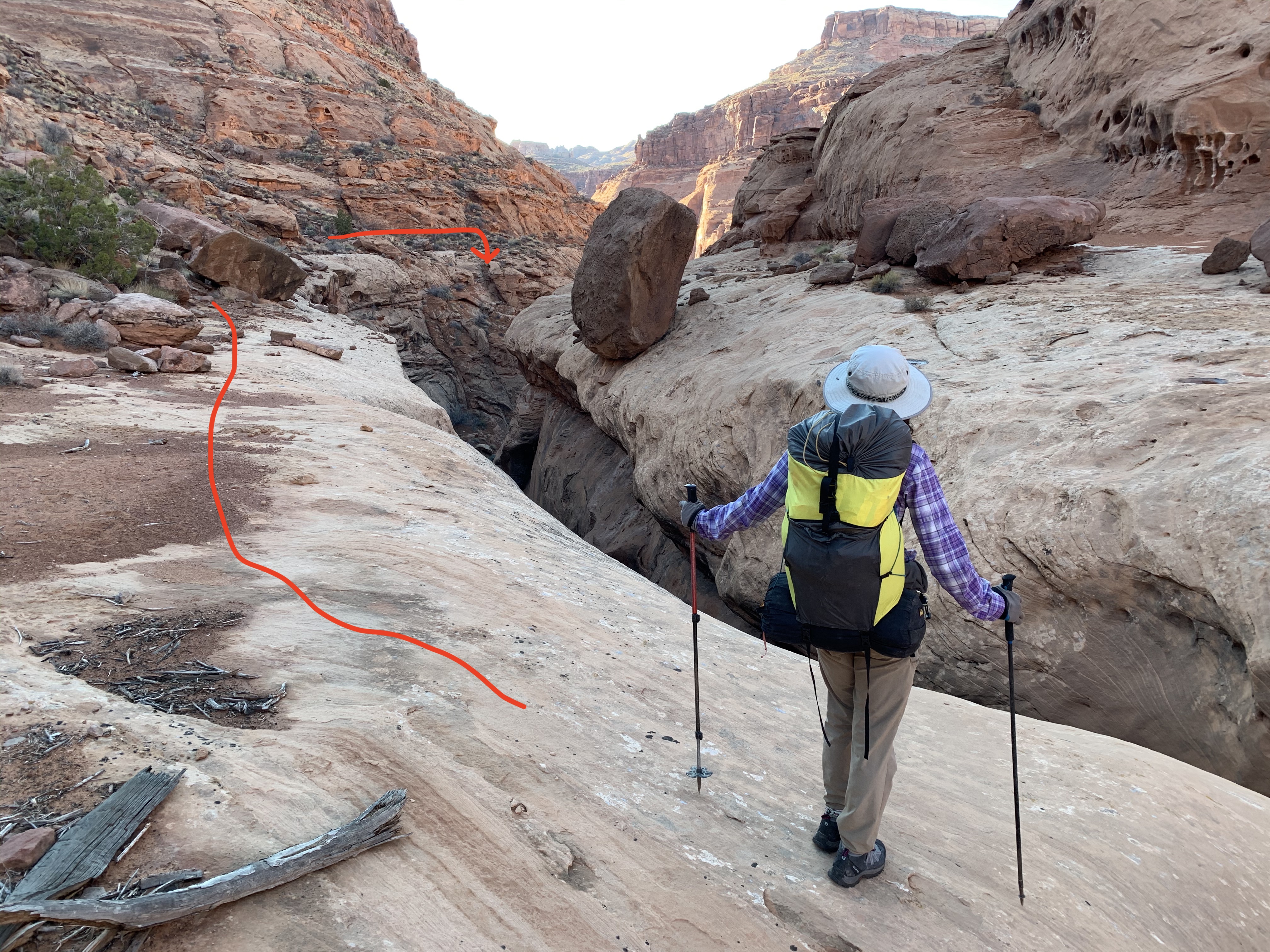
This is the first major drop of the Wingate Bypass. Note the cairn at the extreme top of the downclimb.
The second pic below is at Camp 2 above the NOLS Exit of Sam's Mesa Box Canyon. Coconato camped on his night two below this site.
![IMG_0317[1].JPG](https://backcountrypost.com/data/attachments/59/59561-7e9bc7bdcbdbb7fde608eab6876bf9d7.jpg "IMG_0317[1].JPG")
![IMG_0309[1].JPG](https://backcountrypost.com/data/attachments/59/59563-3ae786ce68b86a20f090333491576ccd.jpg "IMG_0309[1].JPG")
Burr Point; Sam’s Mesa Box Canyon; NOLS Exit; Twin Corral Box Canyon Loop: The Rest of the Story – Utah.
David Johnson and Ian Bartling
October 15-18, 2017
I was intrigued first by this route described by Kelsey in his book Non-Technical Canyon Hiking Guide to the Colorado Plateau 6th ed. It was a loop to begin with, not an out-and-back, plus it was in an area of low-frequency hiking. This description interested me. I also read all of the online sources including the one where a couple bailed after seeing what Kelsey calls “steep downclimbs” within the first two miles of the descent from Burr Point. But most interesting was Coconato and Sys’s video and map account of a March 2015 trip covering what Ian and I duplicated, in part. I say “in part” because we failed to trace their second humungous day which included an attempt to ascend what I’m calling the “Kelsey Exit” up the main fork of Sam’s Mesa Box Canyon and marked in green on their topo map. Coconato and Sys report that they “came within a few feet” of exiting via this route. The steep walls prevented them any kind of safe exit. Instead, they retreated and made a huge descent down some serious steep slickrock to the bed of Sam’s Mesa Box and then ascended another 1500 feet via what I am naming the “NOLS Exit” shown above the “Camp Night 2” icon on Coconato’s excellent map. The NOLS Exit is the route Ian and I took. For Coconato and Sys to not only try to exit the Kelsey Exit and then successfully negotiate the NOLS Exit in the same day is remarkable. These two guys are animals.
However, this NOLS Exit is way more involved than Coconato leads the non-technical hiker to believe. Furthermore, Kelsey doesn’t even mention this route; he’s never even done it, I think. It tasks both the physical and mental prowess of even a seasoned desert-backcountry hiker. We found the boulder field noted by Coconato and previously explained to him by a single party member of 12 or so NOLS students and leaders. However, the boulder problem is only about a third of the total exit-route description. Above the boulder field a gully leads into a red and black-streaked wall that without a pack would demand a rock climbing move of about 5.6. This wall blocked any further safe travel up the main gully. We looked right for other options. The Coconato map shows an extreme right-hand traverse along a ledge and then up to a clump of pines and into another gully that finally tops out onto the Navajo Sandstone (5800 feet) characterized by rounded and spacious slickrock humps and mounds. The top-out is extraordinary scenery because of its wildness and solitude. Plus it’s a great high camp. However, you had better have hauled up the exit six liters of water each to cook dinner and stay hydrated the next morning. The next good water in October doesn’t spring up until reaching the big pools in the Upper South Fork of Twin Corral Box Canyon.
So are you starting to understand my main criticism about these previous route descriptions? Kelsey, Coconato and Sys all purposely leave out hugely important details, or, fail to mention them at all. Coconato leaves out any narrative of the tricky right-hand traverse above the boulder field on the NOLS Exit. Why?
In addition, Kelsey in his published and much acclaimed guidebook only vaguely describes another huge obstacle with the understated phrase, “routefind down in” (116). Coconato and Sys don’t even mention this one. This barrier Kelsey calls the “Bypass Wingate Dryfall” (117) and it’s located on the Coconato map a quarter of a mile above where the 2015 trip map shows they had cut up the main fork of Twin Corral Box for an eight-mile afternoon "jaunt." Why are these descriptions so scant or non-existent?
The Wingate Bypass initially blew us away. I toyed with thoughts of turning around, to be serious with you. The Wingate Bypass is a formidable downclimb that many rock climbers would choose to rappel. When descending the canyon, the bypass is found at the terminus of a ledge that skirts the left side of a large dryfall in the South Fork. I rate the “downclimb” as 5.5. Ian and I are seasoned backcountry hikers and our 35-foot rope was totally essential; without it, we would not have made it down this 45-foot “bypass.” We are both rock climbers, and we both had sticky rubber shoes that worked beautifully on the clean rock. At first, we dropped our packs at the top cairn and butt-slid down to the first ledge, no problem. Then Ian made what he called a “Spiderman Traverse” to the right. This traverse is the crux. All of these upper moves must be made intentionally and without any mistakes. The drop is for all intents and purposes a very exposed, nearly vertical, deadly rock face. I make this conclusion, after experience on Denali, Mount Rainier, Half Dome, Forbidden Peak, Mount Hood, Grand Canyon, Canyonlands and several other serious desert and mountain ventures. Be careful.
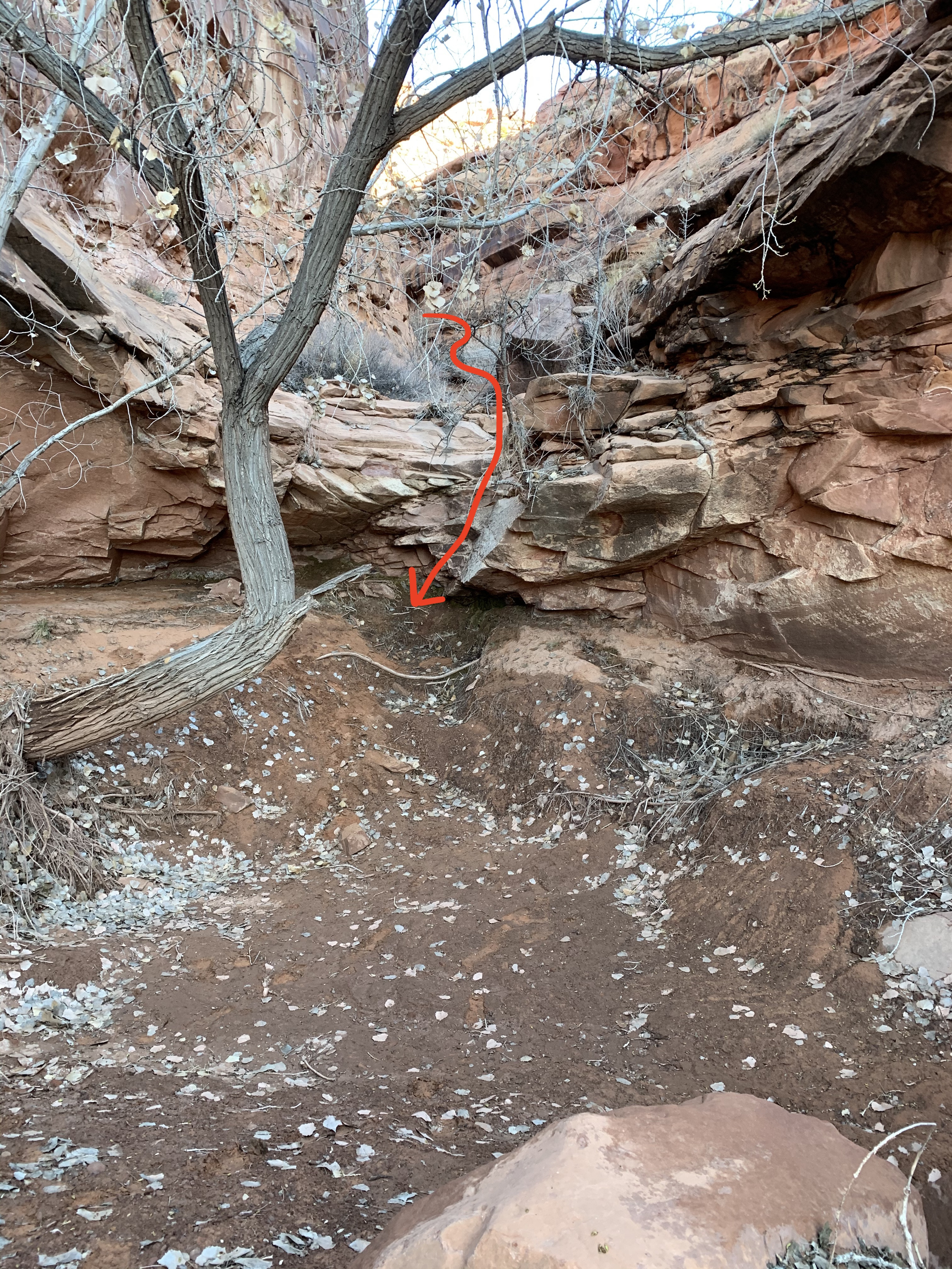
Ian completed the traverse and then moved left over another less-scary ledge to the second major ledge where we would soon lower our packs to. Ian skillfully moved right again over a third ledge onto easier ground and the creek bed. From the creek bed there was still another twelve foot drop that provided absolutely no foot holds after the first four feet. You would have to jump the remaining eight feet or do what I did: rig up a rope loop that hung suspended in the middle of this final eight feet. I would have liked to have videoed this short descent and my keen foot placement into the loop. I comfortably lowered my other foot onto the sloping mud at the base of the rock and pulled my foot out of the loop. I untied the knot in the loop and pulled the rope loose from the mega-ton boulder that rested at the top of the small pour-off. Pretty cool.
Ian descended the whole route solo to begin with and then climbed back up to me. I scooted over the Spiderman Traverse and over to the second ledge. Ian lowered me the two packs from the top with our rope. The packs got pretty beat up while being scraped on the rocks. I stayed with the packs while Ian descended clear to the lowermost creek bed, below the twelve-foot pour-off. The packs were lowered a second time from the second ledge to Ian 40 feet below. Finally, I descended the route, made my nifty foot loop, and we were down safely looking to make camp below the main fork of Twin Corral. This under described, briefly mentioned Wingate Bypass took Ian and me one hour to maneuver. It was easily the most difficult and intimidating section of the entire Sam’s Mesa/Twin Corral Loop.
I know it’s manly, adventurous, cool, mysterious and maybe “proper etiquette” to under describe the difficulties routes throw at climbers and hikers. However, the two descriptions of this loop were the most scant I have ever read. Would I have done the route had I known what I know now? Yes. Would I have been less intimidated by the these two huge problems had I known more about them? Yes.
IN my opinion, Kelsey and Coconato are trying to imitate the route descriptions of "hard men" like Fred Beckey. Fred described rock climbing routes in the Cascades in much the same way. “Move carefully to the right,” meant that if you were not able to make a 5.10 move on a traverse, you would not be finishing this route. I guess Fred meant to add some surprise to the route with these understated descriptions.
Listen, boys, Fred is dead. Be realistic and add the details that will fully inform the backcountry climber and hiker what lies ahead. Don’t be cool, be real.
Other omitted details important to hikers wanting to complete the Sam’s Mesa Box; NOLS Exit; Twin Corral Box Loop (listed in order of importance – most to least):
1) The coordinates to the first serious descent where a rope lowering is advised: N38 10.482; W 110 27.287.
Here (just above the Kayenta Plateau and only ¾ mile from the trailhead) there are two easy downclimbs and then the third, more serious, down climb of 20 feet. We definitely lowered our packs on this third down. I started facing outward and then faced in for the bottom eight feet.
2) The scariest and narrowest ledge traverse underneath the Great Alcove is toward the end and on the north side. But I would agree with Coconato that it looks from afar way more scary than it turns out to be.
3) Water in October was a concern. The water with white salt deposits on the creek bank is, duh, salty. Get water in the larger pools even though they are filled with dead leaves and have deer and bobcat tracks next to them. This water tasted less salty. A pump filter works well.
4) We precisely took Kelsey’s route into the upper South Fork of Twin Corral Box Canyon. We traveled with a GPS and two 7.5 minute topo maps (Burr Point and Robbers Roost Flats). Coconato took a more straightforward gully into the South Fork of Twin Corral which, from his pictures with his route description, looks doable. We chose to go with Kelsey at this point in the trip. The descent here included a bypass of two large pour-offs with the first mile. These required a pack lowering of 15 feet and a doable and easy ledge traverse to a boulder field that fed into the main creek bed. The initial lowering was marked by two cairns.
5) Crossing The Dirty Devil River is not a big deal.
Below is the second drop of the Wingate Bypass on the South Fork of Twin Corral Box. I had to rig a foot loop here.
![IMG_0319[1].JPG](https://backcountrypost.com/data/attachments/59/59562-5dea7da5bbef38304aced15b5403f8e5.jpg "IMG_0319[1].JPG")
This is the first major drop of the Wingate Bypass. Note the cairn at the extreme top of the downclimb.
The second pic below is at Camp 2 above the NOLS Exit of Sam's Mesa Box Canyon. Coconato camped on his night two below this site.
Burr Point; Sam’s Mesa Box Canyon; NOLS Exit; Twin Corral Box Canyon Loop: The Rest of the Story – Utah.
David Johnson and Ian Bartling
October 15-18, 2017
I was intrigued first by this route described by Kelsey in his book Non-Technical Canyon Hiking Guide to the Colorado Plateau 6th ed. It was a loop to begin with, not an out-and-back, plus it was in an area of low-frequency hiking. This description interested me. I also read all of the online sources including the one where a couple bailed after seeing what Kelsey calls “steep downclimbs” within the first two miles of the descent from Burr Point. But most interesting was Coconato and Sys’s video and map account of a March 2015 trip covering what Ian and I duplicated, in part. I say “in part” because we failed to trace their second humungous day which included an attempt to ascend what I’m calling the “Kelsey Exit” up the main fork of Sam’s Mesa Box Canyon and marked in green on their topo map. Coconato and Sys report that they “came within a few feet” of exiting via this route. The steep walls prevented them any kind of safe exit. Instead, they retreated and made a huge descent down some serious steep slickrock to the bed of Sam’s Mesa Box and then ascended another 1500 feet via what I am naming the “NOLS Exit” shown above the “Camp Night 2” icon on Coconato’s excellent map. The NOLS Exit is the route Ian and I took. For Coconato and Sys to not only try to exit the Kelsey Exit and then successfully negotiate the NOLS Exit in the same day is remarkable. These two guys are animals.
However, this NOLS Exit is way more involved than Coconato leads the non-technical hiker to believe. Furthermore, Kelsey doesn’t even mention this route; he’s never even done it, I think. It tasks both the physical and mental prowess of even a seasoned desert-backcountry hiker. We found the boulder field noted by Coconato and previously explained to him by a single party member of 12 or so NOLS students and leaders. However, the boulder problem is only about a third of the total exit-route description. Above the boulder field a gully leads into a red and black-streaked wall that without a pack would demand a rock climbing move of about 5.6. This wall blocked any further safe travel up the main gully. We looked right for other options. The Coconato map shows an extreme right-hand traverse along a ledge and then up to a clump of pines and into another gully that finally tops out onto the Navajo Sandstone (5800 feet) characterized by rounded and spacious slickrock humps and mounds. The top-out is extraordinary scenery because of its wildness and solitude. Plus it’s a great high camp. However, you had better have hauled up the exit six liters of water each to cook dinner and stay hydrated the next morning. The next good water in October doesn’t spring up until reaching the big pools in the Upper South Fork of Twin Corral Box Canyon.
So are you starting to understand my main criticism about these previous route descriptions? Kelsey, Coconato and Sys all purposely leave out hugely important details, or, fail to mention them at all. Coconato leaves out any narrative of the tricky right-hand traverse above the boulder field on the NOLS Exit. Why?
In addition, Kelsey in his published and much acclaimed guidebook only vaguely describes another huge obstacle with the understated phrase, “routefind down in” (116). Coconato and Sys don’t even mention this one. This barrier Kelsey calls the “Bypass Wingate Dryfall” (117) and it’s located on the Coconato map a quarter of a mile above where the 2015 trip map shows they had cut up the main fork of Twin Corral Box for an eight-mile afternoon "jaunt." Why are these descriptions so scant or non-existent?
The Wingate Bypass initially blew us away. I toyed with thoughts of turning around, to be serious with you. The Wingate Bypass is a formidable downclimb that many rock climbers would choose to rappel. When descending the canyon, the bypass is found at the terminus of a ledge that skirts the left side of a large dryfall in the South Fork. I rate the “downclimb” as 5.5. Ian and I are seasoned backcountry hikers and our 35-foot rope was totally essential; without it, we would not have made it down this 45-foot “bypass.” We are both rock climbers, and we both had sticky rubber shoes that worked beautifully on the clean rock. At first, we dropped our packs at the top cairn and butt-slid down to the first ledge, no problem. Then Ian made what he called a “Spiderman Traverse” to the right. This traverse is the crux. All of these upper moves must be made intentionally and without any mistakes. The drop is for all intents and purposes a very exposed, nearly vertical, deadly rock face. I make this conclusion, after experience on Denali, Mount Rainier, Half Dome, Forbidden Peak, Mount Hood, Grand Canyon, Canyonlands and several other serious desert and mountain ventures. Be careful.
Ian completed the traverse and then moved left over another less-scary ledge to the second major ledge where we would soon lower our packs to. Ian skillfully moved right again over a third ledge onto easier ground and the creek bed. From the creek bed there was still another twelve foot drop that provided absolutely no foot holds after the first four feet. You would have to jump the remaining eight feet or do what I did: rig up a rope loop that hung suspended in the middle of this final eight feet. I would have liked to have videoed this short descent and my keen foot placement into the loop. I comfortably lowered my other foot onto the sloping mud at the base of the rock and pulled my foot out of the loop. I untied the knot in the loop and pulled the rope loose from the mega-ton boulder that rested at the top of the small pour-off. Pretty cool.
Ian descended the whole route solo to begin with and then climbed back up to me. I scooted over the Spiderman Traverse and over to the second ledge. Ian lowered me the two packs from the top with our rope. The packs got pretty beat up while being scraped on the rocks. I stayed with the packs while Ian descended clear to the lowermost creek bed, below the twelve-foot pour-off. The packs were lowered a second time from the second ledge to Ian 40 feet below. Finally, I descended the route, made my nifty foot loop, and we were down safely looking to make camp below the main fork of Twin Corral. This under described, briefly mentioned Wingate Bypass took Ian and me one hour to maneuver. It was easily the most difficult and intimidating section of the entire Sam’s Mesa/Twin Corral Loop.
I know it’s manly, adventurous, cool, mysterious and maybe “proper etiquette” to under describe the difficulties routes throw at climbers and hikers. However, the two descriptions of this loop were the most scant I have ever read. Would I have done the route had I known what I know now? Yes. Would I have been less intimidated by the these two huge problems had I known more about them? Yes.
IN my opinion, Kelsey and Coconato are trying to imitate the route descriptions of "hard men" like Fred Beckey. Fred described rock climbing routes in the Cascades in much the same way. “Move carefully to the right,” meant that if you were not able to make a 5.10 move on a traverse, you would not be finishing this route. I guess Fred meant to add some surprise to the route with these understated descriptions.
Listen, boys, Fred is dead. Be realistic and add the details that will fully inform the backcountry climber and hiker what lies ahead. Don’t be cool, be real.
Other omitted details important to hikers wanting to complete the Sam’s Mesa Box; NOLS Exit; Twin Corral Box Loop (listed in order of importance – most to least):
1) The coordinates to the first serious descent where a rope lowering is advised: N38 10.482; W 110 27.287.
Here (just above the Kayenta Plateau and only ¾ mile from the trailhead) there are two easy downclimbs and then the third, more serious, down climb of 20 feet. We definitely lowered our packs on this third down. I started facing outward and then faced in for the bottom eight feet.
2) The scariest and narrowest ledge traverse underneath the Great Alcove is toward the end and on the north side. But I would agree with Coconato that it looks from afar way more scary than it turns out to be.
3) Water in October was a concern. The water with white salt deposits on the creek bank is, duh, salty. Get water in the larger pools even though they are filled with dead leaves and have deer and bobcat tracks next to them. This water tasted less salty. A pump filter works well.
4) We precisely took Kelsey’s route into the upper South Fork of Twin Corral Box Canyon. We traveled with a GPS and two 7.5 minute topo maps (Burr Point and Robbers Roost Flats). Coconato took a more straightforward gully into the South Fork of Twin Corral which, from his pictures with his route description, looks doable. We chose to go with Kelsey at this point in the trip. The descent here included a bypass of two large pour-offs with the first mile. These required a pack lowering of 15 feet and a doable and easy ledge traverse to a boulder field that fed into the main creek bed. The initial lowering was marked by two cairns.
5) Crossing The Dirty Devil River is not a big deal.
Below is the second drop of the Wingate Bypass on the South Fork of Twin Corral Box. I had to rig a foot loop here.
Attachments
Last edited: