High Sierra Trail to Mt Whitney

Mike Jones

Member
Joined
Feb 19, 2013
Messages
147
Hi all! I am planning my big summer trip (June) to High Sierra to Mt Whitney. I was looking on line on how to reserve a permit for this hike and it looks like I can only do it through snail mail/fax? Is this true or am I missing something?

I have my request all filled out and ready to mail in, I just want to know if any one has had any luck with a phone number or email etc?

Also if you have done this hike, any tips or comments are 100% Welcome!
 
I don't know what hike you are actually referring to. I DO know that we walked in to the FS office in probably Bishop or somewhere east side Sierra (actually farther south probably Lone Pine) and got an in-person for that weekday no problem. This was interesting to me but at the time probably not all that unusual it turns out. It was probably 2009. We walked in under the great East Face to near the lake (Iceberg?) and then spent two nights there to climb Whitney and Russel. One idiosyncrasy is that you have to take wag bags and carry all your waste out. Not too bad for us but I got stuck taking the whole teams waste out and 3-4 other a-holes stuff out that had left it there.
 
The High Sierra Trail is a west to east traverese of the range starting in Sequoia NP near I think Grant's Grove and ending on top of Mt Whitney.

I used to guide it on a 9 day trip. I think I ended up doing it 8 times. It's quite spectacular, with a good amount of up and down.

The designated camps have installed food containers, but without portable bear cannisters, one is limited to those spots. Early season there will be challenging creek crossings. Your June trip will have these, plus significant snow in the high country.
 
I did the route back in 2012 and you had to mail or fax in your request then. I was fortunate enough to summit Whitney on a blue moon.

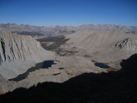
Whitney.jpg
View (looking to the west) of Hitchcock Lakes and Guitar Lake on my way down from Whitney.
 
Last edited:
Yep, if you're starting within Yosemite or SEKI, you need to fax or mail in. Their systems are quite dated now, but I can't imagine that Sequoia or Kings systems are as frustrating as Yosemite's. There are rumors every year that they'll shortly be moving to an online systems but these rarely seem to come to fruition. If you start outside of the parks within Inyo National Forest, permits are distributed online via recreation.gov which is much simpler - unless of course you want to start at Whitney Portal, in which case you have the added logistics of the lottery to contend with.

I'll be hiking Devil's Postpile to Horseshoe Meadow in mid-July. I would love to do the HST some day too, I imagine it will be quite a challenge with snow and water crossings in June though?
 
10704215_1467501283537608_1326603082018500373_o.jpg

I did 2 night sections of it throughout the summer of 2012. So I just got first come first serve wilderness permits from the park backcountry offices.
 
The designated camps have installed food containers, but without portable bear cannisters, one is limited to those spots. Early season there will be challenging creek crossings. Your June trip will have these, plus significant snow in the high country.

The snow after this el Nino year will be interesting to say the least. If anyone has crampon or ice axe suggestions, I am open!
 
The snow after this el Nino year will be interesting to say the least. If anyone has crampon or ice axe suggestions, I am open!

Unfortunately, El Nino kinda petered out this spring :( Snowpack is currently 58% of average in the Southern Sierra - whilst its an improvement on the last few years it didn't turn out to be the monster winter that everyone expected. That being said, June in the Sierra is a challenge almost any year. I know PCTers who found it tough going even last year, the lowest snow year on record. Micro spikes and ice axe would definitely be good to carry I think...
 
The early crossing into Kaweah Basin (day 3, maybe) is high and most definitely with several hours on snow. Was it steep? I don't remember anything too bad up high, but the climb out of Valhalla is exposed in places with cliffy traverses above drops.

After that, not until the Muir Trail does the HST get high again. And of course an ascent of Whitney in June will be snowy from Guitar Lk over the summit and a ways down towards the Portal.

I am very comfortable on steep snow, so take my advice with caution, but I would not bring an ice axe on this outing. I would, however, most definitely bring lightweight hiking crampons and trekking poles.

As mentioned earlier, run-off will be at least as challenging. Down in the Kern there's some sizable creeks that need to be forded.
 
Back
Top