Grand Canyon Loop: Thunder River -> Tapeats -> Kanab -> Sowats

Now that we've enjoyed our summer trip in the mountains, I'm thinking more about our October trip (Deer Creek -> Tapeats -> Thunder River going counter-clockwise). Am I correct that the spot in this photo is on the upper trail along the Colorado? If so, do you remember approximately where it's located? I looked on Google Earth but couldn't figure it out, and I think it would help me prep if I have a sense of where to expect this. Thanks in advance for your help.
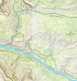
The exposed spot pictured is on the lower trail, so most choose to take the upper route. I believe you can see the spot pictured where the trail skirts the river on the map below. As I remember it, shortly after climbing out of Deer Creek there was a cairn where the trail split and it was easy to spot. The only area where the route got a little hard to follow was on the walk along the river on the approach to Tapeats. There was a fairly large mass of rock blocking what had been a fairly easy path. After short exploratory looks for a way over or under this rock it became obvious that the route climbed up and over that rock. It wasn't difficult, just a change from the rest of the route. My other suggestion would be to cross Tapeats and take the trail up on the north bank if possible. I stayed on the south side and there was significant up and down and some mild exposure. The other side appeared to just follow the creek.

1693756473152.png
 
Ah - glad I asked, as I misunderstood and thought your ledgy spot was on the upper trail.

I've read about the spot approaching Tapeats and how you climb up and over those rocks, and I'm comfortable with that.

I've been curious about the trail on the east (north) side of Tapeats, as the maps make it seem like you could do that pretty easily, but it appears that most people do the west (south) side. I assume that's to avoid crossing the creek, but it seems that a lot of people cross the creek anyway, so I'm wondering if there's another reason people don't go on the east side. If anyone knows, I'll be happy to find out...

One other thing - I'm glad to see that your Gaia screenshot shows the same thing that Gaia does for me in this area. For some weird reason, the map switches right there from detailed topo to undetailed vague, even though I'm using internet and have already downloaded the map for offline use anyway. Weird (and inconvenient) that something's off with their map right where I'll be needing to use it. Oh well, I've got the USGS topo layer downloaded and that works fine; I'll use that when necessary. Seeing your screenshot helped me realize it's a system glitch, not just on my own devices. So thank you for your unplanned help with that!
Yeah I camped at Lower Tapeats and just didn't feel like taking my shoes back off and getting wet first thing in the morning, but my perception was that most prefer to cross if the creek flow allows. I think there's a photo from the original poster above that shows the exposure on the west side. It's fairly wide but does have a significant drop-off. That didn't bother me, but there were several spots where after climbing several hundred feet to avoid cliffs you dropped right back down to creek level. Rough way to start the morning when you're going all the way back to the rim that day!
 
Back
Top