OPALESCENT > TEAR OF THE CLOUDS
A bit of cold drizzle was still falling early the next morning. I didn’t want my only pair of hiking pants to get wetter, so I decided to put on my rain pants over them. I’d brought a brand new pair of Frog Toggs rain pants on the trip. I pulled them on, and the crotch seam immediately split. Apparently my junk was too much for them.
My experience with those pants inspired me to write a product review for one of my favorite Facebook groups, Hikertrash Chic. Here is what I wrote:
Welcome to a new feature here at Hikertrash Chic - product reviews! For my first review, I field tested a product that is both trash and chic - the Frog Toggs ultra light rain suit. Most rain gear that is advertised as waterproof and breathable turns out to be neither of those things. Indeed, the biggest complaint about Frog Toggs is that they aren't breathable. I disagree. I found that the crotchless variety does a great job of airing out your junk.

Crotchless rain pants
We had a quick breakfast before packing up and returning to the trail. We hiked back down to the dam and passed through the campsites on the far side. After a short distance we reached a junction. The previous afternoon we had continued around the east side of Lake Colden on our way up Mount Colden. This time we headed east, upstream along the Opalescent River. Before long we crossed a suspension bridge over the cascading stream. We continued upstream, passing a number of pretty cascades.

Cascade on the Opalescent River
This stretch of trail was even worse than most of the trails in the Adirondacks. This one was mostly a jumble of slippery rocks and boulders periodically interrupted by deep mud holes. We were able to avoid the worst of the mud by hopping on rocks and logs, but that quickly became tedious. Despite our best efforts, it wasn’t long before we were covered in mud up to our knees. We had encountered plenty of mud getting to Lake Colden, but this stretch of trail took it to another level.

This is the trail

Larry on the trail

Larry avoiding stairs that were not particularly helpful

Still the trail, unfortunately

Surprise! Also the trail.

A bridge of sorts
The mud was so incredible, I am forced to update my list of states with the best mud. New York comes in at #3! Mud probably isn’t the first thing that comes to mind when you think of New York. That’s either because you are thinking of New York City, or because you have never been to the Adirondacks. First, let me remind you that New York City was built on an island surrounded by a swamp. Billy Joel knew what he was talking about when he wrote his hit song, “New York State of Mud”.
The updated list:
STATES WITH THE BEST MUD
1) North Dakota – North Dakota mud is special. It’s like wet cement that is also incredibly slippery. It is literally impossible to walk through or drive on. Its most impressive quality though is that it somehow sticks to itself. It’s easy to think, “oh well, I’ve already got mud on my shoes – it can’t get any worse. WRONG! North Dakota mud just accumulates. One of the top 10 leading causes of death in North Dakota is paralysis due to an over-accumulation of mud*.
2) Florida – Most people think that Florida is all beaches and cartoon mice. NOPE! Large portions of the middle parts of the state consist of high-quality mud. In fact, the land area of Florida can be broken down into five basic categories by substance, ranked below, from largest to smallest:
1) Golf courses / retirement communities / Disney World (all combined due to the difficulty involved in separating them)
2) Mud – often with alligators and a surprising variety of exotic snakes lurking just below the surface.
3) Miami
4) Trailer parks
5) Sand
3) New York
4) Mississippi – Mississippi mud is so famous, there are a variety of desserts and at least one song named for it.
5) Wyoming – Another new addition to the top five list. I never fully appreciated Wyoming mud on any of my previous visits, but last summer’s trip was a new experience. Seeing my hiking partner getting swallowed by it was eye-opening!
Honorable Mention – Tennessee, Utah, South Carolina, New Hampshire, Michigan
* unverified
We now return to the trip report, already in progress…
Before long we climbed steeply onto a ridge above the river. The river cuts through a minor slot canyon here. The topo map labels this as “Flume”. That is understating things a bit. The river roared through the narrow canyon below us, tumbling over a series of waterfalls. I wandered off the trail to the edge of the chasm a couple of times hoping to get a good view. At the second, I spotted a nice waterfall just upstream, near the beginning of the canyon. Unfortunately, the view was partially blocked by foliage. I needed a better look at it.
I stashed my pack and wandered along the rim of the slot searching for a way down. I spotted one possible route, but it was on steep wet rock with nothing to hold on to. I continued on and found a narrow gully that looked passable. I crawled under some brush and scrambled down to a boulder on the edge of the river. From there I had a nice clear view of the waterfall at the upper end of the slot. It was only 20’ tall, but it covered the entire width of the canyon. I took a few photos before scrambling back out, retrieving my pack, and hurrying after Larry.


"Flume"
We hiked on to a junction at the Uphill Shelter. We continued upstream, passing several groups of backpackers along the way. A few of them included French Canadian women. As we passed each group I began to notice something odd about them, aside from their accents. Everyone else we passed, including the men in their own groups, was covered in mud just like us. Not the French-Canadian women. They were all spotless. They all looked like they had just fallen out of a fashion magazine, without a speck of dirt on them. How were they pulling that off? There was no way to get to where we were without crossing dozens of bottomless mudpits. Perhaps they levitated? Or rode in on the back of a unicorn? Maybe they are magic creatures, and the mud just falls right off of them. My sources tell me that their shit doesn’t stink either.
We hiked on to the next junction, where our trail turned right towards Mount Marcy. We took a quick side trip on the Lake Arnold Trail though, as we needed water and a dry place to eat lunch. That worked out well. After a couple of minutes we crossed a sturdy bridge over the river and found a shelter on the far side. We got water from the river and had lunch at the shelter.
COLD RAIN AND SNOW (REPRISE)
Afterwards we backtracked a short distance and began a steep climb towards Lake Tear of the Clouds. As we neared the lake we found fresh snow on the ground and in the trees. The lake was completely fogged in, but the conditions lent it an eerie beauty. A few minutes after passing the lake we reached a 4-way junction. The trail to the left goes to Mount Marcy, the highest peak in New York, while the trail to the right goes to Mount Skylight. It was snowing hard at this point, which made our next decision easy. I had originally hoped to take a side trip up to Mount Skylight, but that didn’t seem like a great idea in a blizzard. We actually ran into a guy later on that had just traversed Mount Marcy. He told us that he had crossed the icy summit in a howling wind while being pelted with snow and ice. Every surface up there had been ice covered. We were sorry we missed that!


Merry Christmas!
We continued straight ahead, down a trail that was somehow even worse than what we had climbed. This “trail” was basically just a boulder-strewn gully. Everything was wet and icy, and our progress was slow. We were part of the way down when a deranged, mostly toothless hiker somehow “ran” past us, laughing boisterously as he went. We found out later that he was attempting to summit most of the peaks in the immediate area that day, despite the weather. The general consensus was that he was quite insane.
We made it down to Panther Gorge late that afternoon. The shelter there was full, which was disappointing. I’m not a fan of shelters, but I’m also not a fan of wet, and I’d had plenty of wet for one day. Luckily for us, we had dropped below the snow line, and the rain had tapered off. We continued beyond the shelter and found a decent campsite that only had a few mudpuddles. While we were setting up camp, I noticed a patch of blue sky. The only question was whether that was a sign of improving conditions or merely a sucker hole.
That night I slept in my only dry clothes remaining – long underwear, a hat, and my last pair of socks. Usually I only carry 2 pairs of socks on a backpacking trip. I grabbed a 3rd pair right before locking the car and starting down the trail. That may have been the best decision of the trip. I don’t think I’ve ever regretted carrying an extra pair of socks. For the last half of this trip, those remaining dry clothes stayed in a ziplock when I wasn’t wearing them at night.

THE YELLOW BRICK ROAD
Day 4 was a big one. Our goal was to hike down to Upper Ausable Lake, cross the river, climb the “Elevator Shaft”, summit Mount Colvin, and descend to a campsite on Gill Brook. Our back up plan was…there was no back up plan. Because the Ausable River valley is private property, Gill Brook was the only legal place to camp within “reasonable” striking distance.
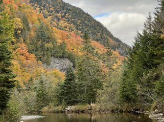
We got an early start, packed up, and started up the Bartlett Ridge Trail away from Marcy Brook. After a short but annoyingly steep climb we made a long traverse below Mount Haystack. After the traverse we began the long descent to Upper Ausable Lake. This part of the hike was quite pleasant. It was a warm, sunny morning, which was a nice change. Even better, we passed through a gorgeous forest of birch and maple. The fall color was spectacular, both above and below. The trees were gorgeous, but the best part of this hike was walking through a golden carpet of leaves all the way to the lake. After 3 days of mud and ice and wet rocks, this walk was delightful.


Wardens Camp
We reached Upper Ausable Lake at the Warden’s Camp. There is a cluster of buildings here, though we didn’t seen anyone around. I wanted to take a side trip over to see the lake, but the signs made it clear that we were required to stay on the official trail. We followed the trail downstream along the Ausable River, enjoying views of the fall color on the peaks above.


A short distance downstream from the Warden’s Camp we stopped for lunch and pulled some of our wet gear out to dry in the sun. We lingered a bit too long in the sunshine, but it was delightful after the first few days of our trip.
THE SHAFT
After lunch we continued downstream to a bridge over the river. On the far side I fudged the rules a bit and went off trail a short distance to take in the view of Lower Ausable Lake.

Afterwards Larry and I resumed the hike. A few minutes later we passed a sign that said “Elevator Shaft” featuring an arrow pointing straight up.

Well-named
The sign was not an exaggeration. A minute later we started the climb. The trail was so steep, I was afraid of sliding backwards. We struggled upward, and a few minutes later the grade eased a bit. I thought the worst was behind us. Hah!
The climb had just begun. A long, steep, grueling ascent followed. The climb was relentless, and progress was slow. It was also technically demanding. At one point I had to put my foot on a slippery waist-high rock and push myself up without anything to grab onto. Predictably, my foot slipped and I felt myself falling. How does a person fall up? I’m not exactly sure, but I managed to do it. I landed hard on my left shoulder, bounced, rolled twice, and smacked into a tree. The last bit was fortunate – it was a long way back down the elevator shaft from there.

One of the easier parts
I was a little beat up, but I didn’t seem to be injured. I dusted myself off, picked myself up, and crawled up the rock I had slipped on. There was no additional drama after that, just a lot more hiking uphill.
It was late afternoon when we reached the gap between Mount Colvin and Blake Peak. We took a break there before beginning the final climb up the ridge to Mount Colvin. This stretch of trail was challenging, too. It was steep and rugged, with some scrambling required. It was worth it though. The summit featured spectacular views of the Ausable lakes and the surrounding peaks.


Views from Mount Colvin
It was getting late, and Larry was eager to start the hike down to camp. We were both still hoping to get there before dark. I decided to linger for a few minutes and give him a head start. A couple of minutes later I heard him yell, “well this is interesting!”. That isn’t what I wanted to hear. I had been hoping for a quick, easy, straightforward descent to Gill Brook. Ha! That wasn’t in the cards.

Larry thought this part of the trail was "interesting"
The descent from the summit may have been more challenging than the climb. There was a lot of scrambling, a few ladders, and very little normal walking. Darkness fell, and still the hike dragged on. We hiked another hour in the dark before we reached the marker for the spur trail to the upper campsite near Gill Brook. We were exhausted, so we headed that way. We set up camp, and then I ventured out to get water. There wasn’t an apparent water source near the campsite, so I headed back to the trail. I didn’t see a path, so I bushwacked down towards the creek. I eventually made it down, but that was tedious after a long day of hiking. My water bag doesn’t close, and it is a miracle that I made it back to camp without spilling much of it.
We discussed our plans for the last 3 days of our trip over dinner. The original plan for day 5 (Tuesday) was a dayhike from Gill Brook to the Fishhawk Cliffs, Indian Head, Lower Ausable Lake, the Sawteeth, and possibly Gothics. And back. We were exhausted from our hike up the Elevator Shaft and over Mount Colvin, and the original plan seemed pretty ambitious. Also, the weather forecast for Thursday looked pretty terrible, with heavy rain. If we stuck with the original plan, we would have to pack up and hike out in the rain and then drive 8 hours.
I suggested tweaking the plan. Instead of taking a layover, we could backpack down to Lower Ausable Lake and take our time enjoying it. We’d spend the night at a campsite on Wedge Brook and hike out the following day. That would get us out ahead of the bad weather and back home a bit early. Larry was in favor of the change, so we planned to pack up in the morning.