fossana
Member
- Joined
- Jan 11, 2018
- Messages
- 883

~4 years ago I first learned about the Escalante Overland Route in a post from Alan Dixon (a.k.a. Adventure Alan). After my first time on Steve Allen's Stevens/Fold loop, I was hooked on his remote, semi-technical routes. I have an alpine rock/remote trad route climbing background, and picked up backpacking after moving to the Colorado Plateau as a way to access more remote locations than were reasonable with long day hikes. The Overland route mixes old cattle routes and moki steps with more cryptic canyon navigation. To quote Allen on the Overland Route:
It is not intended to be done in one push, though that would be an incredible accomplishment... Most sections of the Overland Route are appropriate only for hardcore canyoneers who are also experienced rock climbers. Difficult climbing on steep walls, demanding route-finding problems, long distances between known water sources, and other assorted perils await the bold explorer.
Often the route descriptions are brief. You must be well versed in map reading and not be intimidated by long stretches of complex and convoluted terrain. You will not find the Overland Route marked on the maps in the guide. The dedicated and adventurous will be forced to assemble the puzzle on their own.
Last year was a crazy year family health-wise. My mountaineer/backpacker stepdad quickly deteriorated and passed away from inoperable brain cancer, then a few months later my mom suffered a severe hemorrhagic stoke while doing volunteer trail maintenance. While she miraculously regained the ability to hike again, it was a wake-up call to me to start burning down my harder outdoor projects while I still had the ability to do so. As I did with longer solo alpine traverses, I started previewing sections of the Overland route to work out the route finding. For the Overland route Allen tends to provide just enough info to figure things out with competent route finding, although some sections were either particularly vague or alternative technical routes were discovered in the vicinity.
Self-imposed rules
- Start on Highway 12 at Haymaker Bench, end at 40 Mile trailhead
- No bypassing overland technical sections (e.g. Shofar, Hydra, Ichabod) with alternative, often shorter river wades.
I will not be posting a detailed route or waypoints, because that spoils the (Type II) fun.
Day 1. Highway 12 to Brigham Tea Bench
I didn't make my daily mileage goal of 10 miles due to my late start. Shuttling Hole in the Rock always takes me longer than I think it should. I exited Boulder Creek on a 4th class slab slightly before Allen's exit to avoid a potential swim. I found a nice slickrock bench to camp on Brigham Tea Bench.


Day 2. Brigham Tea Bench to Silver Falls Bench
This time the Gulch was dry. Dry shoes made one of the subsequent 4th class upclimbs easier. Fortunately there was water in Horse Canyon to avoid a diversion to the Escalante River. The next section over Big Bown Bench was long, dry, and sandy. I made it down the tricky Cliff Springs descent and back up to Silver Falls Bench before dusk.


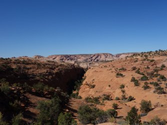
Day 3. Silver Falls Bench to Baker Bench
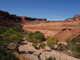
This section was a welcome change to sandy Big Bown Bench. The terrain is varied and undulating, through broken cliff bands, along the rim of beautiful Choprock Canyon, then dropping into Neon Canyon. After Neon I headed back up onto the rim to cross Ringtail Canyon via an efficient route I had previously scouted. I knew that Baker Canyon was a different story; I was unable to find any early crossings, and heading it and the next set of unnamed canyons would kill a good portion of the day. I camped at the head of the west fork of Baker.


Day 4. Baker Bench to Scorpion Bench
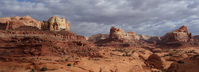
To stick to my overland rule, I opted to finish heading the Baker Bench canyons instead of downclimbing the sketchy moki steps to Kelsey's ruin camp and wading the river. I crossed the Escalante further downstream, then found the "5.4" chimney climb to access Scorpion Bench. The subsequent slab to gain the rim felt more sketchy than the chimney. The stretch across Scorpion Bench was more undulating than I remembered, crossing countless petrified sand dunes. I decided to camp on the rim instead of descending down into Scorpion Gulch to avoid potential mosquitoes.


Day 5. Scorpion Bench to Fold Canyon
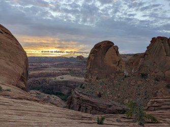
I was rewarded with incredible sunrise views. In the morning I headed down to Scorpion Gulch, then back up to contour on ledges, eventually meeting up with the Horse Trail. After a long sand dune descent I thrashed along the Escalante River for a short distance. My least favorite part of this route is the slog up the loose rocky hill to gain the rim just before Fold Canyon. I took a different approach than on my recon, which was slightly less unpleasant. Once you reach the Fold Canyon rim, the slickrock walking became easier. It was a windy evening, so I tucked behind some boulders just before the boulder slot downclimb into Fold.


Day 6. Fold Canyon to Hydra Canyon
I squeezed through the boulder cave, and ascended the alternate Fold exit I found on my scouting trip. There was a tarantula to greet me. I've hiked Fold Canyon at least 4 times, and each time is just as stunning as the first. Today, the partly cloudy skies made for a dramatic backdrop. I passed the Swan Neck Bend downclimb to the river, and headed over to the last main technical section, Shofar, Hydra and Ichabod Canyons.
This is the least described section and has the highest concentration of technical upclimbs and downclimbs. There is one especially exposed downclimb to a tiny ledge. As the day wore on, the wind picked up. By the time I dropped into Hydra it didn't seem reasonable to find a sheltered site on the opposite rim, so I decided to cut out early and camp in the canyon. 3 fighter jets flew low over the canyons (see the righthand side of the last photo in this section), setting off booming echos. It was a miserable night with blowing sand.


Day 7. Hydra Canyon to 40 Mile TH (via the Bobway)
In the morning I did the last 5th class climb on the route to gain the Hydra rim, then headed toward Ichabod. I forgot about the intermediate multi-forked canyon, which required heading. I found my alternate route into Ichabod, then mentally prepared myself for the giant boulder hopping and poison ivy in the lower part of the canyon. Even though the sandy slog out of the Bobway is annoying I decided to take it instead of wading upstream to Fools Canyon. The hill wasn't so bad, surprisingly.
I made decent time down the Long Branch of Sleepy Hollow, hitting Coyote Gulch before dark. Having climbed it countless times, I knew I could do the 4th class exit across from Jacob Hambiln in the dark if needed. I had to pull out my headlight ~1.5 miles from the Coyote Gulch exit. The climb out was uneventful, but it took me forever to get from there back to South Lobo with almost zero moonlight. The temps were dropping rapidly, so I decided to do the remaining trek to 40 Mile trailhead in the morning. I woke up to temps in the 30s, and walked the remaining few miles to 40 Mile, then back to South Lobo.


Epilogue
I set off ~11:30 am on Oct 6th and finished at ~10:00 am on Oct 13th, 7 days. A lot of the water sources I had used on my spring recons were dry, so I ended up carrying more water than I would have preferred. I made no rappels. I lowered my pack 3 times, although one was unnecessary had I done a better job of scouting for an easier downclimb. Outside of Coyote Gulch I saw 4 people (2 in Horse Canyon/Little Death Hollow and 2 in Neon Canyon).
On Hole in the Rock Road ~5 miles from Highway 12 I hit a rut, which triggered a fuel cutoff alert on my van. My vehicle went into limp mode, and I was dreading a potential tow. I had previously marine epoxied a hairline crack on the neck of my fuel tank and thought it had failed. I verified that my fuel system was intact. Luckily I had data access on my cell phone. I watched a few horrible YouTube videos, consulted the manual, and was able to reset it once I located the switch. Crisis averted, I retrieved my motorcycle, made a quick stop at Nemo's, and headed home.
Attachments
Last edited: