To start, I want to thank @Bob for sharing his route with me. Upon inspection, the section up from Stevens Lakes to Goat Lake immediately popped out at me, but Bob confirmed that the route was indeed feasible. We certainly hit some sketchy terrain, but finished the trail alive and well.
The Sawtooths have always been on my list of places to visit, but I never got the chance to get out there until this past week. I was amazed by the scenery and geology of the mountains. The elevations are modest, which was easier on the lungs than other western ranges, but the jagged nature of the peaks made the area no less scenic. The route we took is shown below:
Click here to view on CalTopo
Watching the weather forecast in advance, things looked real grim. For the first 2 days, it looked like on and off rain with a storm total of 1-2 inches. Not exactly what we were looking for in what is generally a pretty dry region. Our original plan was to make a loop from Grandjean, up through trailer lakes, and essentially do our route in reverse. Upon seeing the forecast, we decided to pivot and start from Iron Creek, shortening our first day of hiking. This ended up paying off.
Day 1:
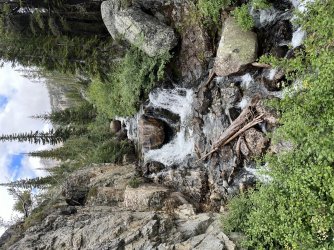
We started our day at a motel along the drive from Boise to Stanley, and had a lazy morning with breakfast before making our way into Stanley. We only had a bit over 6 on trail miles to do that first day, so we were not overly concerned about getting out. The rain on the drive was torrential; definitely not the kind of weather we looked forward to hiking in. Luckily, around 2 PM, the rain stopped, and we were on trail by 2:30. We made quick work of the trail up to Sawtooth Lake, and found ourselves in an eerie scene, with clouds draped over the surrounding ridges and peaks.

As we made our way around Sawtooth Lake, the clouds broke, revealing the summit of Mount Regan. We made our way down the trail, and set up camp just before it dropped into the North Fork of Baron Creek. That night, the rain was ferocious. We definitely lucked out and avoided being out in the worst of the weather. My tent held up wonderfully, though my whole party was not quite as lucky.
.jpg")

Day 2:
We awoke to a light drizzle after the overnight downpours, which led to another slow morning out of camp. This time, we were out by around 10:30, but had a fair bit of hiking ahead of us. On the agenda was to drop down into the North Fork of Baron Creek until its confluence with the main fork, then head back up the valley to Baron Lake. The hike down the valley was beautiful, with the clouds doing a nice job enhancing the scene.

The valley went on for a long time, until we finally hit the junction at the end of the north fork. It was considerably warmer down in the valley, which was welcome after the morning's chilly temps at higher elevations. From there, it was back up the valley towards Baron Lakes. The valley seemed to go on forever without gaining much elevation, until we finally reached the climb below Baron Creek Falls. The climb up the falls was steep but manageable, and the view back down the valley from the top of the falls was stunning.
From there, it was only a couple miles to Baron Lakes, but unfortunately our luck ended and we got some rain before getting into camp. As evening fell, the clouds broke, revealing some blue skies that would stay with us for the rest of the trip.


Day 3:
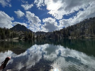
Our first off trail day began just as we would've hoped, with a mirror-like reflection over Baron Lake.

We got moving around 9:30, and made our way quickly up to Upper Baron Lake. While the lake was very pretty, I felt that its lower counterpart was definitely the grander of the two. That said, the view back towards the valley where we came was quite special.

From Upper Baron Lake, we headed off trail, and up and over a saddle separating the Baron Creek and Braxton Creek drainages. The Braxton Creek Drainage is very scenic, and its beauty is enhanced by its remoteness, as there are no trails through the valley.

The way down from the saddle was quite loose and slow. A preview of what was to come the next day. It was already noon, and we had made very little progress, which had me a bit nervous about time. Luckily, the off trail travel through Braxton Creek Valley was very simple, and we made pretty quick work circling above Braxton Lake and up to the pass on the other side of the drainage. From there we could see the better part of our route the next day, over the pass we dubbed "Labor Day Pass". It looked impossibly high and steep, but given the beta I had received on the route, I was confident that it would go.

From the pass, it was more easy travel past Stevens Lakes, until we made our way to our camp at a set of unnamed lakes a shade under 9000 feet. We got to bed early, prepared for the next day, which would be the focal point as well as the crux of the trip.

Day 4:
We were a bit delayed getting out of camp, leaving around 8:30. From camp, it was way up to our first and smaller pass of the day, at about 10,000 feet. The way up was straightforward for the most part, with the exception of the last 100-200 feet, which were a bit loose. Not every step was assured, but as far as off trail travel goes, it could've been far worse. The views from the climb and at the top of the pass were exceptional as we entered some of the highest country in the entire Sawtooth Range.


From the top of the pass, we had a great view of our the high alpine valley below, and up to our next objective, Labor Day Pass. From our vantage point, the pass looked like a steep, loose mess.

Still, before we got to the pass, we still had to descend the steep slopes below us. While footing was definitely not assured, the slope was navigable and as long as we took it slow, it was not an uncomfortable descent by any means. From there, it was a nice walk across the valley, and up to the base of Labor Day Pass. The pass looked significantly less daunting once we were at the bottom, and the ascent was actually simple, more so than our earlier ascent to the smaller pass. Upon reaching the top, the views were absolutely breathtaking in either direction.


From reading previous trip reports, I knew that the next descent would likely be the toughest of the trip. However, I don't think any of us expected it to be as difficult as it ended up being. We ended up traversing left from the top of the pass and descending down an impossibly loose scree chute. The kind of stuff that moves on the slightest touch. It took us around an hour to get down the short distance, and I spent about 70 percent about it doing a no-shame butt scoot, and coming out of it with a massive rip in my shorts. However, we were all alive, uninjured, and contemplating the descent we had just managed. We descended just to lookers right of the snowfield in the center of the picture.

The valley below the pass was gorgeous, with Thompson Peak towering above us.

From here, we still had a long way to descend to our target of Goat Lake. However, despite the perilous descent we had just experienced, we were doing pretty well on time and had plenty of daylight. The next descent was about 800 feet to the set of lakes around 9000 feet, above Goat Lake. There was some tricky route finding on the descent, but we were able to stay in pretty manageable terrain. Plus, the incredible scenery continued as we made our way down through the valley.

After a slow descent, we were at the bottom of the valley, and were greeted by absolutely spectacular views back up the valley we just descended.


Finally, it was time to make the final descent to Goat Lake. This descent was not too bad, and before we knew it we were back on the use trail around Goat Lake. However, the trail was extremely frustrating, as we had to scramble over several bluffs, many of them certainly not for the faint of heart. By 6:00 PM, we had made camp near the outlet of Goat Lake. While it only took us 9.5 hours, the day had felt extremely long given the wild terrain we had passed through. It was certainly one for the ages, with some world class terrain and probably the sketchiest terrain any of us had ever encountered while backpacking.
Camp at Goat Lake was really exceptional. We had the place to ourselves, and while the secret is definitely out, I was in awe of the place. The scale of the granite wall towering above the lake combined with the views of Thompson Peak through the notch above the lake make for a truly picture perfect setting. Somehow, I do not have any good pictures of the lake, but a quick google search will show you its grandeur. We spent the evening hanging out by the lake, and it was quite warm even though the sun had gone behind the ridge hours ago. Eventually, we went to bed, with dreams of the town food awaiting us the next day.
Day 5:
We made quick work of the descent down from Goat Lake and back to the trailhead. The trail was steep, though it was nothing compared to the prior day's harrowing terrain. There was a pretty inversion, with clouds hanging in the valley above Stanley, but other than that, the day was quite uneventful.

Pretty soon, we were back in Stanley enjoying a nice breakfast at the bakery in town, reflecting on the last 5 days. The Sawtooths lived up to expectations and more, giving us spectacular views and challenging terrain, including a classic rocky mountain humbling on the way off of the high pass. Now back to work and time to dream about the next trip.
The Sawtooths have always been on my list of places to visit, but I never got the chance to get out there until this past week. I was amazed by the scenery and geology of the mountains. The elevations are modest, which was easier on the lungs than other western ranges, but the jagged nature of the peaks made the area no less scenic. The route we took is shown below:
Click here to view on CalTopo
Watching the weather forecast in advance, things looked real grim. For the first 2 days, it looked like on and off rain with a storm total of 1-2 inches. Not exactly what we were looking for in what is generally a pretty dry region. Our original plan was to make a loop from Grandjean, up through trailer lakes, and essentially do our route in reverse. Upon seeing the forecast, we decided to pivot and start from Iron Creek, shortening our first day of hiking. This ended up paying off.
Day 1:
We started our day at a motel along the drive from Boise to Stanley, and had a lazy morning with breakfast before making our way into Stanley. We only had a bit over 6 on trail miles to do that first day, so we were not overly concerned about getting out. The rain on the drive was torrential; definitely not the kind of weather we looked forward to hiking in. Luckily, around 2 PM, the rain stopped, and we were on trail by 2:30. We made quick work of the trail up to Sawtooth Lake, and found ourselves in an eerie scene, with clouds draped over the surrounding ridges and peaks.
As we made our way around Sawtooth Lake, the clouds broke, revealing the summit of Mount Regan. We made our way down the trail, and set up camp just before it dropped into the North Fork of Baron Creek. That night, the rain was ferocious. We definitely lucked out and avoided being out in the worst of the weather. My tent held up wonderfully, though my whole party was not quite as lucky.
Day 2:
We awoke to a light drizzle after the overnight downpours, which led to another slow morning out of camp. This time, we were out by around 10:30, but had a fair bit of hiking ahead of us. On the agenda was to drop down into the North Fork of Baron Creek until its confluence with the main fork, then head back up the valley to Baron Lake. The hike down the valley was beautiful, with the clouds doing a nice job enhancing the scene.
The valley went on for a long time, until we finally hit the junction at the end of the north fork. It was considerably warmer down in the valley, which was welcome after the morning's chilly temps at higher elevations. From there, it was back up the valley towards Baron Lakes. The valley seemed to go on forever without gaining much elevation, until we finally reached the climb below Baron Creek Falls. The climb up the falls was steep but manageable, and the view back down the valley from the top of the falls was stunning.
From there, it was only a couple miles to Baron Lakes, but unfortunately our luck ended and we got some rain before getting into camp. As evening fell, the clouds broke, revealing some blue skies that would stay with us for the rest of the trip.
Day 3:
Our first off trail day began just as we would've hoped, with a mirror-like reflection over Baron Lake.
We got moving around 9:30, and made our way quickly up to Upper Baron Lake. While the lake was very pretty, I felt that its lower counterpart was definitely the grander of the two. That said, the view back towards the valley where we came was quite special.
From Upper Baron Lake, we headed off trail, and up and over a saddle separating the Baron Creek and Braxton Creek drainages. The Braxton Creek Drainage is very scenic, and its beauty is enhanced by its remoteness, as there are no trails through the valley.
The way down from the saddle was quite loose and slow. A preview of what was to come the next day. It was already noon, and we had made very little progress, which had me a bit nervous about time. Luckily, the off trail travel through Braxton Creek Valley was very simple, and we made pretty quick work circling above Braxton Lake and up to the pass on the other side of the drainage. From there we could see the better part of our route the next day, over the pass we dubbed "Labor Day Pass". It looked impossibly high and steep, but given the beta I had received on the route, I was confident that it would go.
From the pass, it was more easy travel past Stevens Lakes, until we made our way to our camp at a set of unnamed lakes a shade under 9000 feet. We got to bed early, prepared for the next day, which would be the focal point as well as the crux of the trip.
Day 4:
We were a bit delayed getting out of camp, leaving around 8:30. From camp, it was way up to our first and smaller pass of the day, at about 10,000 feet. The way up was straightforward for the most part, with the exception of the last 100-200 feet, which were a bit loose. Not every step was assured, but as far as off trail travel goes, it could've been far worse. The views from the climb and at the top of the pass were exceptional as we entered some of the highest country in the entire Sawtooth Range.
From the top of the pass, we had a great view of our the high alpine valley below, and up to our next objective, Labor Day Pass. From our vantage point, the pass looked like a steep, loose mess.
Still, before we got to the pass, we still had to descend the steep slopes below us. While footing was definitely not assured, the slope was navigable and as long as we took it slow, it was not an uncomfortable descent by any means. From there, it was a nice walk across the valley, and up to the base of Labor Day Pass. The pass looked significantly less daunting once we were at the bottom, and the ascent was actually simple, more so than our earlier ascent to the smaller pass. Upon reaching the top, the views were absolutely breathtaking in either direction.
From reading previous trip reports, I knew that the next descent would likely be the toughest of the trip. However, I don't think any of us expected it to be as difficult as it ended up being. We ended up traversing left from the top of the pass and descending down an impossibly loose scree chute. The kind of stuff that moves on the slightest touch. It took us around an hour to get down the short distance, and I spent about 70 percent about it doing a no-shame butt scoot, and coming out of it with a massive rip in my shorts. However, we were all alive, uninjured, and contemplating the descent we had just managed. We descended just to lookers right of the snowfield in the center of the picture.
The valley below the pass was gorgeous, with Thompson Peak towering above us.
From here, we still had a long way to descend to our target of Goat Lake. However, despite the perilous descent we had just experienced, we were doing pretty well on time and had plenty of daylight. The next descent was about 800 feet to the set of lakes around 9000 feet, above Goat Lake. There was some tricky route finding on the descent, but we were able to stay in pretty manageable terrain. Plus, the incredible scenery continued as we made our way down through the valley.
After a slow descent, we were at the bottom of the valley, and were greeted by absolutely spectacular views back up the valley we just descended.
Finally, it was time to make the final descent to Goat Lake. This descent was not too bad, and before we knew it we were back on the use trail around Goat Lake. However, the trail was extremely frustrating, as we had to scramble over several bluffs, many of them certainly not for the faint of heart. By 6:00 PM, we had made camp near the outlet of Goat Lake. While it only took us 9.5 hours, the day had felt extremely long given the wild terrain we had passed through. It was certainly one for the ages, with some world class terrain and probably the sketchiest terrain any of us had ever encountered while backpacking.
Camp at Goat Lake was really exceptional. We had the place to ourselves, and while the secret is definitely out, I was in awe of the place. The scale of the granite wall towering above the lake combined with the views of Thompson Peak through the notch above the lake make for a truly picture perfect setting. Somehow, I do not have any good pictures of the lake, but a quick google search will show you its grandeur. We spent the evening hanging out by the lake, and it was quite warm even though the sun had gone behind the ridge hours ago. Eventually, we went to bed, with dreams of the town food awaiting us the next day.
Day 5:
We made quick work of the descent down from Goat Lake and back to the trailhead. The trail was steep, though it was nothing compared to the prior day's harrowing terrain. There was a pretty inversion, with clouds hanging in the valley above Stanley, but other than that, the day was quite uneventful.
Pretty soon, we were back in Stanley enjoying a nice breakfast at the bakery in town, reflecting on the last 5 days. The Sawtooths lived up to expectations and more, giving us spectacular views and challenging terrain, including a classic rocky mountain humbling on the way off of the high pass. Now back to work and time to dream about the next trip.