Big West Fork of Red Breaks to The Cosmic Navel

What a beautiful canyon...

One question - why is it that pretty much every trip report I've seen has people ascending it, rather than descending it? I know the approach is from that direction, but why not hike around and then go down? I can't really think of any canyon I've been through that going UP is easier than going down. Am I missing something?

And just to complain, I also wish the 'Cosmic -navel - ashtray -etc' names would die off - Islomania Dome from the Canyon Names Database is so much more fitting. http://www.math.utah.edu/~sfolias/canyontales/canyonames/ Right, intuitive cat? :)
 
Bill, have you maybe seen some spots for camping, north of the navel?
Thanks in advance. :)
 
And just to complain, I also wish the 'Cosmic -navel - ashtray -etc' names would die off - Islomania Dome from the Canyon Names Database is so much more fitting. http://www.math.utah.edu/~sfolias/canyontales/canyonames/ Right, intuitive cat? :)

why? the name "islomania" was coined by ryan cornia. it's a great name, but i'm not aware of anyone calling it that before him. he was just the first to publish it.

i had heard it called both the volcano and the ashtray in 2006 by locals, fwiw. it's certainly been known by many names.
 
why? the name "islomania" was coined by ryan cornia. it's a great name, but i'm not aware of anyone calling it that before him. he was just the first to publish it.

i had heard it called both the volcano and the ashtray in 2006 by locals, fwiw. it's certainly been known by many names.

Personal preference. The Volcano isn't bad, I just personally dislike the 'Cosmic ___' names. I mean really, a navel or ashtray? Just my opinion. Really dig Islomania.
 
Personal preference. The Volcano isn't bad, I just personally dislike the 'Cosmic ___' names. I mean really, a navel or ashtray? Just my opinion. Really dig Islomania.

I call it Rainbow Roundtop. :)

Just joking obviously. But, as I said in another thread, it is odd that this feature goes by so many names. I'm guessing that's partially because all the names kinda suck! (too harsh?) I'll stick with Volcano -- which still bugs the inner geologist in me a little bit.

Interesting thought on descending W.Fork. I guess the approach is to blame just because people are excited to get into the slot right away. I did it both directions as an out and back, but I think if doing a loop, you are right, it would be better to enter from the top.

- Jamal
 
As long as its not the ashtray I don't care what anyone calls it.

Interesting thought on descending W.Fork. I guess the approach is to blame just because people are excited to get into the slot right away. I did it both directions as an out and back, but I think if doing a loop, you are right, it would be better to enter from the top.
The most difficult and tightest pinch is near the top of the slot so If you could make it past that you should be able to make it down the rest of the canyon. Down climbing may be another story, not saying it cant be done but there's at least 3 that may exceed most peoples comfort level going either direction. From the bottom up if you reach a point you cant ascend you just return the same way to came. The hardest climb is 13' + and if you have any sort of width you cant shimmy up the slim crack. I had to use a hand line there and I there was no way I could of gone up without. The Big West Fork felt like it had a half dozen drops that if they were just a tad bit bigger it could only been descended with tech gear. In my head I've been trying to compare it to other walk through slots like LWHC, Moonshine, Ding, Dang, Peak-a-Boo, Spooky, ect. but its more difficult than any of those.

My bottom line is....

The best slot is on the top end so following the crescendo of kickassery is well worth it.
If you start at the bottom in the main fork you will run into the first slot with a few climbs here (37.661996,-111.342391) if you had problems by the time you reach the Big West Fork bypass (37.665612,-111.34241) just stick to the other forks :)
A slim person should have no problems going up or down the big west fork (down would seem a bit more sketchy too me) and I wouldn't recommend any to do it solo.
I would love to do this again but I would NOT include the cosmic whatever with the Big West Fork. I would go up the Big West Fork down the West Fork as a lolly pop. Then I would drive out on the Harris Wash road to the edge of the sand traps, park (37.666616,-111.327016) , and walk to the Esca-VolCano-McThingy to shoot sunset and maybe some stars.
 
What a beautiful canyon...

One question - why is it that pretty much every trip report I've seen has people ascending it, rather than descending it? I know the approach is from that direction, but why not hike around and then go down? I can't really think of any canyon I've been through that going UP is easier than going down. Am I missing something?

And just to complain, I also wish the 'Cosmic -navel - ashtray -etc' names would die off - Islomania Dome from the Canyon Names Database is so much more fitting. http://www.math.utah.edu/~sfolias/canyontales/canyonames/ Right, intuitive cat? :)
We may just do that this spring. See the whatchamacallit first, then descend. We'll have an opportunity to try it either way. I thought about that also because I don't want to miss this holey place. I really don't feel offended by any of the current names. Maybe I will feel different once I'm there.
By the way great TR!!
 
What a beautiful canyon...

One question - why is it that pretty much every trip report I've seen has people ascending it, rather than descending it? I know the approach is from that direction, but why not hike around and then go down? I can't really think of any canyon I've been through that going UP is easier than going down. Am I missing something?

And just to complain, I also wish the 'Cosmic -navel - ashtray -etc' names would die off - Islomania Dome from the Canyon Names Database is so much more fitting. http://www.math.utah.edu/~sfolias/canyontales/canyonames/ Right, intuitive cat? :)
Ashtray is just so crass, ya know. its such a redneck name. i mean, why not name bryce canyon the land of standing cigarette butts?
it's funny how white men feel the need to name everything. ;)
i suggest that when people go there, they remain silent and ask it it's name. it will tell if one knows how to listen.

also, in terms of the ascend/ descend issue - i am totally with you Nick. I had a very difficult time as a short stocky individual climbing up & over some of the obstacles and the next time go through i definitely want to go top to bottom and think it would be much more enjoyable for me.
 
Nice report with awesome pictures, like usual Bill.

Since several years I have been planning to do this hike but it doesn't seem a good idea to do it all alone as it seems to be much harder than I thought.

I would never do it alone. too many of the obstacles are awkward enough to be worrisome. not super technical, but depending on one's body frame, a few spots were a bit too wide for me compared to height, which made stemming and chimneying a bit tough for me. I had a couple of spots when i was in there where i had to pretty much do a leaping start to get my body weight up high enough for me to grab hold & swing my body up because i could not get proper leverage (i am only 5'5" and a heavy little bugger). there was one spot where i was hanging on the chockstone and simply had no way to get myself up & over in the position i was in and my friends were already up (and we did not have a rope with us) and i just had to drop and reposition and it scared them to death when i did it.
as Bill said, the obstacles can be seriously taxing.
i like Nick's Idea of doing it top down.
 
What a beautiful canyon...

One question - why is it that pretty much every trip report I've seen has people ascending it, rather than descending it? I know the approach is from that direction, but why not hike around and then go down? I can't really think of any canyon I've been through that going UP is easier than going down. Am I missing something?


yeah, you and everyone else are missing out on the "Sneak Route" :sneaky:

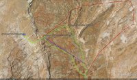
Red Breaks Sneak Route.jpg


-park at the Drill Site
-punch in the coords into your GPS. keep in mind, that last Oct my 5 and 8 yo successfully went old school unassisted by completing the green loop with map and compass.
-cruise the approach.
-enjoy the BWF descent.

oh man, descending BWF is a world of difference. It becomes very** family friendly. and the return doesnt taint the experience like the normal route does.

between waypoints 4 & 5 is an itermittent shallow slot. good for keeping kids occupied on the return. follow the "Purple Line" BWF drop-off to Passage) for a short and speedy x-country return.

"Red line" - BWF --> Cosmic somthin' -er-other--> cool Iron concretion/formation land --> return

south of car park - very cool slickrock land... [ deleted ]*

....
I' would've posted up a TR last fall, but a good contingency of BCP'ers have raised the bar way too high for photography. ;)

*Edited (3/11/13 5pm): Contents removed for preservations' sake.
** Edited (3/12/13 10:30 am): Adverb struck. upon further review, "very" comes across as misleading. refer to post #43 on page 3 for clarification.
 
-park at the Drill Site...

Looks like a good route -- good to know you can access BWF via those cliffs to the west w/o any problem.

But... was the road open all the way to the drill site? The GSENM maps used to show it ending about 1.5 miles farther north. I know they blocked/posted the northern split of the road several years ago. Then I thought there was a recent crack down due to somebody looting the moki marbles in the area.

Thanks,
- Jamal
 
Jammer - The road was open at least
Looks like a good route -- good to know you can access BWF via those cliffs to the west w/o any problem.

But... was the road open all the way to the drill site? The GSENM maps used to show it ending about 1.5 miles farther north. I know they blocked/posted the northern split of the road several years ago. Then I thought there was a recent crack down due to somebody looting the moki marbles in the area.

Thanks,
- Jamal

The road "appeared" to be open as of last Oct, and the other handful of times i've been out over the last 14-years or so. dont ever recall any road blockage to the drill site even during the same year the GSENM closed off motorized traffic to spencer canyon/ponderosa valley.

the whole Spencer Flats always had a history of legal rock-hounding-cum-looting. prior to the establishment of the GSENM, spencer flats was a destination for geologists and rock/mineral hounders. there are unfortunately plenty of rock-hounding guidebooks containing spencer flat beta, even later editions, post-GSENM establishment, still contains the beta. thats what the GSENM dealing with out there on spencer flats.

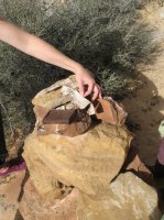
i have a hunch that the road remains open due to legal issues. we discovered the following whilst exploring about along the imposing wall north of the drill site parking. IMG_1680.JPG
IMG_1677.JPG

it is a survey monument that contains a mete-and-bounds legal description and map for the areas oil/gas leases. The accompanying map (not in the photo) showed that the drill site parking and a good portion of the road out to it is contained within the lease.

i reckon a phone call to the GSENM would help clarify/confuse the issue regarding access.
 
I've driven the road to the drill site (I think). It was deep, soft sand but was open.

i've been able to get a subee outback and a honda pilot through it w/o any issues. 200 yards of it maybe. kinda intimidating. just drive fast.:D
 
yeah, you and everyone else are missing out on the "Sneak Route" :sneaky:

View attachment 8536


-park at the Drill Site
-punch in the coords into your GPS. keep in mind, that last Oct my 5 and 8 yo successfully went old school unassisted by completing the green loop with map and compass.
-cruise the approach.
-enjoy the BWF descent.

oh man, descending BWF is a world of difference. It becomes very family friendly. and the return doesnt taint the experience like the normal route does.

between waypoints 4 & 5 is an itermittent shallow slot. good for keeping kids occupied on the return. follow the "Purple Line" BWF drop-off to Passage) for a short and speedy x-country return.

"Red line" - BWF --> Cosmic somthin' -er-other--> cool Iron concretion/formation land --> return

south of car park - very cool slickrock land... [ deleted ]*

....
I' would've posted up a TR last fall, but a good contingency of BCP'ers have raised the bar way too high for photography. ;)

*Edited (3/11/13 5pm): Contents removed for preservations' sake.

Excellent Route!
only question I have is how sandy is the road to the Drill Pad? I have not been out that road yet do to being warned of some deep sand.
I've been thinking about doing the narrow 'slot' canyon to the south of the drillpad that heads to the SW.
oh, wait, i just saw the above post. nevermind.
 
I
Jammer - The road was open at least

The road "appeared" to be open as of last Oct, and the other handful of times i've been out over the last 14-years or so. dont ever recall any road blockage to the drill site even during the same year the GSENM closed off motorized traffic to spencer canyon/ponderosa valley.

the whole Spencer Flats always had a history of legal rock-hounding-cum-looting. prior to the establishment of the GSENM, spencer flats was a destination for geologists and rock/mineral hounders. there are unfortunately plenty of rock-hounding guidebooks containing spencer flat beta, even later editions, post-GSENM establishment, still contains the beta. thats what the GSENM dealing with out there on spencer flats.

i have a hunch that the road remains open due to legal issues. we discovered the following whilst exploring about along the imposing wall north of the drill site parking. View attachment 8558
View attachment 8559

it is a survey monument that contains a mete-and-bounds legal description and map for the areas oil/gas leases. The accompanying map (not in the photo) showed that the drill site parking and a good portion of the road out to it is contained within the lease.

i reckon a phone call to the GSENM would help clarify/confuse the issue regarding access.

I am 99.9% sure that road is open. there is a road that heads south next to the corral on the flats just north of the 'pyramid' that is now closed.
The LE Ranger actually made a huge bust last year of a ring of Moqui Marble thieves who were in possession of 2 tons of them in the Los Angeles area which they had obtains from spencer flats. He patrols the area often and there are now cameras at undisclosed locations on Spencer Flats.
 
The LE Ranger actually made a huge bust last year of a ring of Moqui Marble thieves who were in possession of 2 tons of them in the Los Angeles area which they had obtains from spencer flats. He patrols the area often and there are now cameras at undisclosed locations on Spencer Flats.

This is why we can't have nice things.
 
oh man, descending BWF is a world of difference. It becomes very family friendly. and the return doesn't taint the experience like the normal route does.

I think this statement could get a lot of folks in over their heads.
 
Back
Top