- Joined
- Aug 9, 2007
- Messages
- 12,967
October 2011
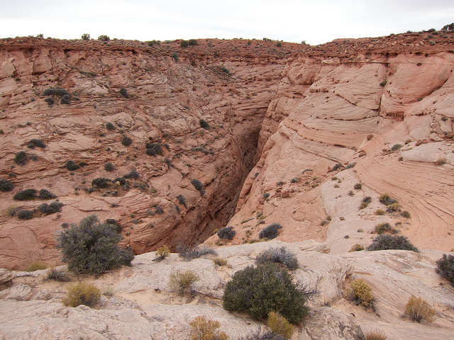
I've been going on a fair amount of canyoneering trips lately so it seemed appropriate to knock one off the list I've always wanted to do; Blue John Canyon. Blue John is famous because it is the place where Aron Ralston became pinned under a boulder and subsequently self-amputated his arm after being trapped for 5 days. Since the release of the movie 127 Hours, Blue John has become even more famous, drawing tourists from all over the world to see the 'Ral-stone' and the beautiful 'Blue Pool' from the movie.
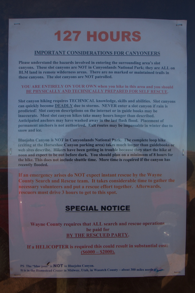
So before I get too far into my trip report I am going to give a few warnings as this might end up in search results for people looking to go visit Blue John because of the movie. First off, there is no Blue Pool in Blue John Canyon. Sorry folks. The Blue Pool scene in the movie was actually filmed in a hot spring called 'The Crater' at the Homestead Resort in Midway Utah, a couple hundred miles NW in the mountains outside of Salt Lake City. It's basically just a hot spring down in a cave that has an open top. The film crew had to build rigging over the top to even make it possible for people to jump in from above.
Second, Blue John is not in Canyonlands National Park, nor is it anywhere near Moab (unless you consider a 2-3 hour drive to be nearby. It is in one of the most remote and inhospitable places in the entire country, The San Rafael Desert, specifically in the area known as Robber's Roost. The nearest pavement is upwards of 40 miles away and the nearest hospital or gas station is much further than that. You should not be out there unless you are fully prepared for self reliance. This means ample supply of water, food, shelter and everything else you would need to survive. Cel phone service is patchy although I do tend to get a bar or two of Verizon from the high points and areas closer to the rims of Labyrinth Canyon, other carriers not so much. A SPOT, sat phone or other type of emergency locator beacon is not a bad idea to have on hand but don't be an idiot. Those devices are only to be used in a situation where all possibilities of self-rescue have been exhausted.
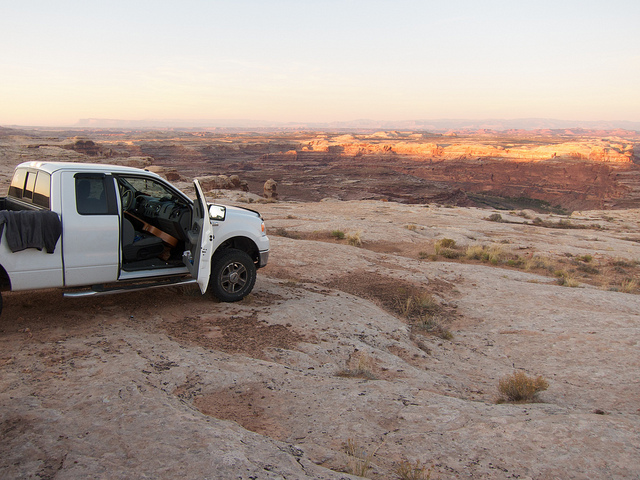
Third, a well-maintained high-clearance 4WD vehicle is highly recommended. Granted, many of the main roads are graded and can be passed by a car in most conditions, but the conditions are totally unpredictable and it would be a very unfortunate place to become stuck. Even small amounts of rain can wash the road out and turn them into a sloppy, clay mud hell hole. Some sections have deep soft sand that blows across the road that can also make passage difficult, even for 4WD vehicles.
Now that that's all been said I'd better throw in a standard disclaimer. I am in no way responsible for anything you do after reading the content of this trip report or any other information on my website. And and all maps, directions, mileage, estimated times, rappel lengths or any other type of information is offered purely for entertainment purposes and are not intended to be used for navigation. Your safety is your responsibility!
One last thing to share before moving onto the trip report. There is a kiosk at the junction that heads out towards Blue John & Hans Flat with a nice warning sign for those seeking Blue John. I didn't take a photo of it on this trip but I did last spring when I went to The Maze. Take a look.
And finally, on to the trip report!
Despite the fact that there were 8 people on this trip, I ended up driving down solo. Kind of nice to be able to jam out and sing along to some tunes but the traffic going through Utah county was a nightmare. I can't wait until they finish the I-15 reconstruction there. Only a year and a half longer *sigh*. I made it to Green River around 9pm, well after dark but even with the traffic, I was running well ahead of the rest of the group. I decided to take a slow pace down the San Rafael Desert road. I had some thoughts about stopping and shooting some star trails along the way but it didn't feel right. Hate to sounds like a big pansy but it's kinda eerie out there on a moonless night by yourself. So I decided I'd just keep going for our pre-determined camp for the night.
30 some odd miles of dirt road later, I found camp and got setup for the night. About an hour later everyone showed up (now close to midnight) and we all gathered around the fire. The mood was jovial. Thor played the guitar and sung for us. Everyone was happy to be out there and stoked for what was to come the next morning.
We did make one major adjustment to our plan that night. The original plan was to follow most of the 'Ralston Route' which is down Blue John and our Horseshoe Canyon via the incredible rock art galleries. It is a very long day with a 9 mile sand slog after completing the slot sections of Blue John Canyon. To add to that, we intended to descend Little Blue John canyon rather than the non-technical West Fork. This would add two 80-foot rappels and a few spicy down-climbs, one of most of us ended up rappelling.
There were a few big factors that made that plan somewhat unappealing once we were down there. First, the late arrival kept us all up well past 2am. Not great for a pre-dawn start. Second, the days this time of year are so short. We only had 10 and a half hours of daylight to complete what is said to be an 8-10 hour day. Add to that our technical entrance through Little Blue John and a group size of 8 and it's easy to assume that we would have ended up on the long end of that estimate. And last, Thor and Angela had brought along their little Shihtzu, Dice. Even if we could get him through the slot without issues, we'd still be at risk of a ticket if we tried to bring him through Horseshoe Canyon which is a detached unit of Canyonlands National Park where no dogs are allowed.
So with all of that we decided to just go down Little Blue John, hike down to the 'Ral-stone' and then hike back out via the West Fork or West E/E Exit. This would give us plenty of time to sleep in, take photos and get back to camp in time for sunset. Here is a map with my GPS tracks from the route. MY GPS logged 9.62 miles for the route and did a surprisingly good job of keeping the track through the slot. I fixed a couple of spots on the displayed track.
[parsehtml]
<iframe width="640" height="640" frameborder="0" scrolling="no" marginheight="0" marginwidth="0" src="http://maps.google.com/maps/ms?msa=0&msid=214533597045798101523.0004b145b94dfa9d2ec51&ie=UTF8&t=p&vpsrc=6&ll=38.390917,-110.27544&spn=0.08611,0.109692&z=13&output=embed"></iframe><br /><small>View <a href="http://maps.google.com/maps/ms?msa=0&msid=214533597045798101523.0004b145b94dfa9d2ec51&ie=UTF8&t=p&vpsrc=6&ll=38.390917,-110.27544&spn=0.08611,0.109692&z=13&source=embed" style="text-align:left">Little bluejohn Canyon - Backcountrypost.com</a> in a larger map</small>
</br></br>
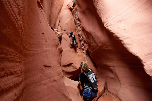
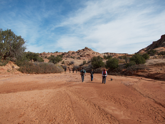
[/parsehtml]With the late night, I slept right through what looked like a really nice sunrise in camp. By 9:30 everyone was packed up and we were on our way to the trailhead for Little Blue John. The road was in pretty good conditions with the occasional 4WD section where a washout had occurred. But then we found this.
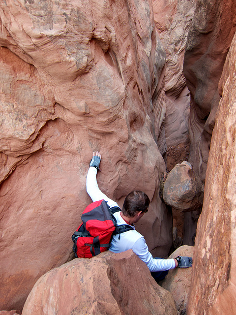
With some creativity, we made it past the obstacle and were on our way to the trailhead where we loaded up and set out. The hike down into Little Blue was pretty uneventful until the first obstacle. At first we thought this was the first rappel because of the webbing setup from a tree, just like the first rap was described. But soon we realized this was just the 30 foot down-climb. The Kauppila crew (including the pup) all down-climbed and the rest of us rapped. I definitely would not rap this one again. It looks kind of big at first but if you climb down into it, it is not difficult.
Austen rapping the down-climb.
The next obstacle was a little trickier. It's a down-climb over a chokestone and in front of another chokestone. I would estimate 15-20 feet. Not very difficult but definitely a spot to pass packs down.
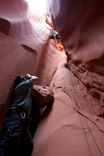
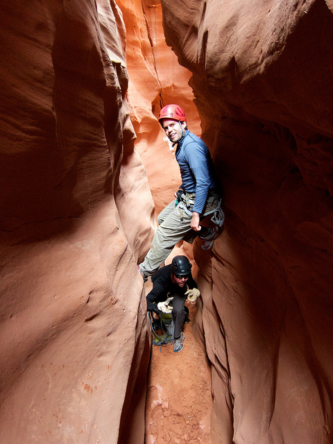
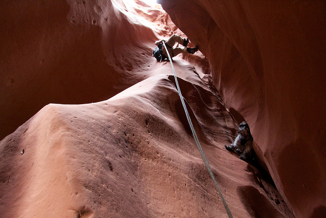
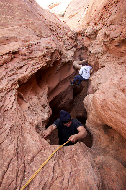
Soon after that we found ourselves at the first official rappel, roughly 80 feet long from a tree on the left. It takes quite a bit of webbing to set this up so come prepared in the event that it's no longer there or damaged/worn.
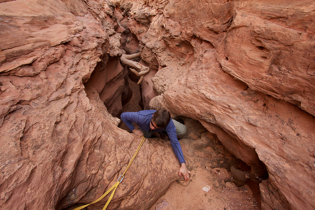
This first rappel goes straight into a very narrow and deep section of the canyon so getting decent photos from the top was pretty much impossible. Here's a shot of Nilauro shooting Tim on his descent.
And another of Tim near the bottom.
Soon after Tim, the dog was sent down. I thought they were going to put him in a backpack but they decided to lower him on webbing instead. It was hilarious to watch. It's a good thing they had a proper dog harness for him. To anyone thinking of critiquing me for taking a dog through a slot or lowering one off of an 80-foot cliff, save it, I was just along for the ride on this one.
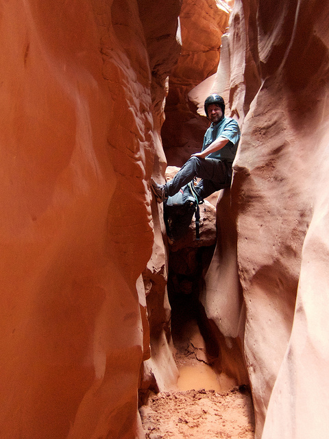
The section between the two raps is beautiful and very narrow with a few little down-climbs and obstacles. There were a couple of spots with a bit of mud and water that were mostly avoidable. That's Austen (stemming) and Tim in between raps.
Nilauro stemming over one of the wet spots. As you can see, not much water.
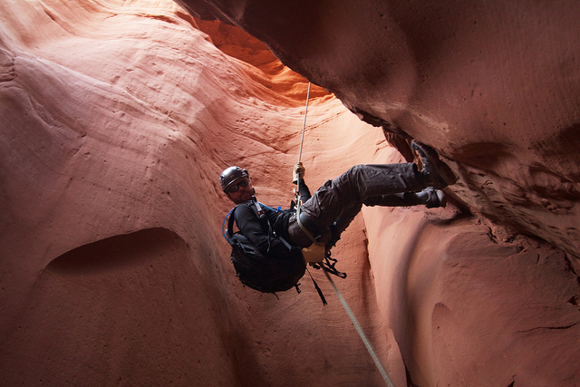
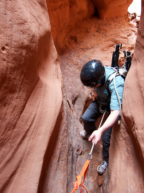
The second rap was off of some webbing wrapped around a huge car-sized rock. It was pretty tough to inspect the webbing but fortunately there was another, newer piece around a smaller stone. It was tiny bit sketchy getting onto the rappel deck. There's only a small spot to stand between the huge boulder and the 80 foot drop. Having a method to clip into the anchor was really nice for the climb down to it and for getting your pack back on before getting on rope. I didn't really get a good shot here but this is Nilauro starting down the rappel. You can see how narrow it is where this drops down.
Once again, the dog was lowered with webbing but this time we had a snag. Near the bottom of the rap, the slot chokes up in the back. Dice decided he didn't like going down anymore and went into doggy-stemming mode and would not come down. Thor had to rap down and pick him up out of the crack.
Looking back up canyon towards the last rap in Little Blue John.
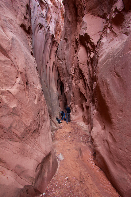
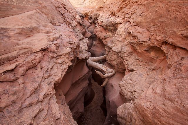
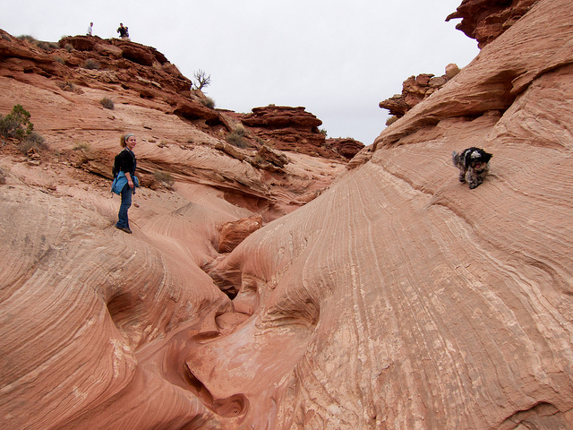
That was it for the technical portion of Little Blue John. From there it was a beautiful walk through long narrow section before reaching the main fork. I don't recall but it stayed narrow like this for quite a ways.
Main Fork Blue John Canyon just below the confluence with Little Blue John.
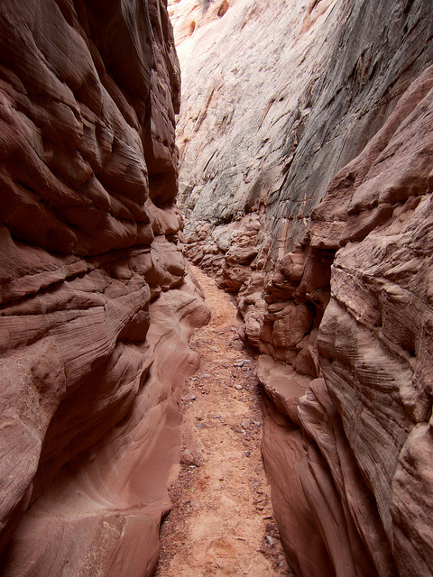
The canyon widens more and more as it continues towards the lower slot section where Aron Ralston incident occurred.
After what seemed like about 2 miles, we made it to the lower slot section and the famous 'S-Log'. I hate to admit it here on the inter webs, but I totally wussed out here. It's about a 15-foot drop down but not an easy climb back up and since we were no longer doing the through route, this would have to be negotiated in both directions. The immediate drop bells out and overhangs quite a bit so no chance of stemming up. The other option is to do a wide stem up to the S-Log and then follow the ledge on the right (or maybe left) back to the top. That was a bit exposed for my taste, particularly the last leap of faith that had to be done to get past the big hump you can see in the lower right of this shot.
So after much deliberation, I decided I would rather call this my turnaround point rather than figure out how to get my fat ass back up. I figured I'd be waiting a while but just minutes later Tim was already back at the drop off. The 'Ral-stone' was not far down canyon but it was wet and muddy beyond it. There would be no cheesy poses in front of the rock on this trip. Most of the group came back pretty quick and climbed back up. Here's a shot of Nick (not me) and Thor trying the various methods. It didn't seem too difficult to get to where Thor is (foreground) on the up climb but beyond that there was nothing to get a hold on.
Austen probably made it look the easiest out of everyone who climbed up the overhang.
As we hiked back up Blue John, we noticed a huge wall of dark clouds moving in. We weren't too worried about the flash flood potential at this point but we were worried about the sleeping bags left out in the open back in camp. So instead of our initial plan to hike up the West Fork, we opted for the West E/E exit because it looked faster on the map. It offered some great views but I think we probably took the wrong path somewhere along the way, the trail we were following was very lightly worn.
The little canyon right before we topped out. Dice was fun to watch in this section, he had issues picking the best path.
We made it back to camp with just minute before the sunset over the horizon. It's a damn good thing we didn't go for the full Ralston Route or we would have been hiking in head lamps.
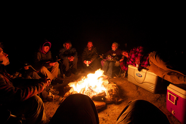
I know I heard people say 'we need to do a group shot' at least a few times on this trip. We never did so I guess this shot I took around the campfire will have to do. Everyone's there, I am represented by my knees and Nilauro by his shoes on the left.
The next morning we made our way back to Green River. We stopped at the Chaffin Geyser to see if it might erupt but after 20-30 minutes we gave up. Next up was a stop in Black Dragon canyon just north of where I-70 cuts through the San Rafael Reef. I thought it was going to be a little hike to get to the rock art panel but it turned out to be something like 5 minutes.
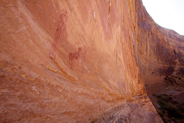
The rock art was okay. Most of it was faded and traced in chalk by some modern douchebags. Fortunately there was something much more interesting that I had heard about. There is a huge cave in Black Dragon canyon that was formed when a deep alcove collapsed. The front of the alcove looks like nothing more than a huge pile of rocks and debris but if you climb to the top of it, there is a small opening where you can access the cave. Here's a little clip I made of some of my shots and a short video of the inside of the cave.
If you watched the video, you saw all of these shots but here's a few from inside the cave.
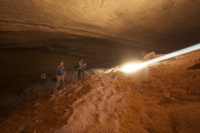
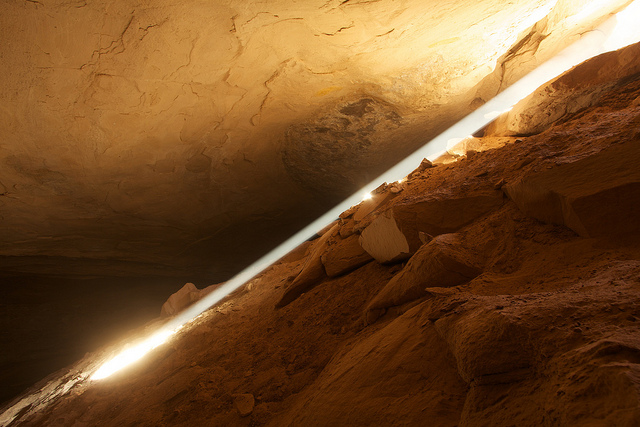
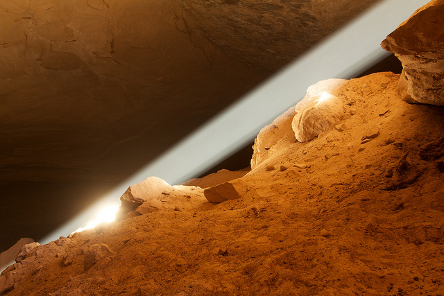
The light beam in the cave was a real treat. I'd like to go back a few weeks later in the year to see it at a lower angle. After Black Dragon we stopped at one more rock art site, The Juggler, and then it was home to Salt Lake.
I've been going on a fair amount of canyoneering trips lately so it seemed appropriate to knock one off the list I've always wanted to do; Blue John Canyon. Blue John is famous because it is the place where Aron Ralston became pinned under a boulder and subsequently self-amputated his arm after being trapped for 5 days. Since the release of the movie 127 Hours, Blue John has become even more famous, drawing tourists from all over the world to see the 'Ral-stone' and the beautiful 'Blue Pool' from the movie.
So before I get too far into my trip report I am going to give a few warnings as this might end up in search results for people looking to go visit Blue John because of the movie. First off, there is no Blue Pool in Blue John Canyon. Sorry folks. The Blue Pool scene in the movie was actually filmed in a hot spring called 'The Crater' at the Homestead Resort in Midway Utah, a couple hundred miles NW in the mountains outside of Salt Lake City. It's basically just a hot spring down in a cave that has an open top. The film crew had to build rigging over the top to even make it possible for people to jump in from above.
Second, Blue John is not in Canyonlands National Park, nor is it anywhere near Moab (unless you consider a 2-3 hour drive to be nearby. It is in one of the most remote and inhospitable places in the entire country, The San Rafael Desert, specifically in the area known as Robber's Roost. The nearest pavement is upwards of 40 miles away and the nearest hospital or gas station is much further than that. You should not be out there unless you are fully prepared for self reliance. This means ample supply of water, food, shelter and everything else you would need to survive. Cel phone service is patchy although I do tend to get a bar or two of Verizon from the high points and areas closer to the rims of Labyrinth Canyon, other carriers not so much. A SPOT, sat phone or other type of emergency locator beacon is not a bad idea to have on hand but don't be an idiot. Those devices are only to be used in a situation where all possibilities of self-rescue have been exhausted.
Third, a well-maintained high-clearance 4WD vehicle is highly recommended. Granted, many of the main roads are graded and can be passed by a car in most conditions, but the conditions are totally unpredictable and it would be a very unfortunate place to become stuck. Even small amounts of rain can wash the road out and turn them into a sloppy, clay mud hell hole. Some sections have deep soft sand that blows across the road that can also make passage difficult, even for 4WD vehicles.
Now that that's all been said I'd better throw in a standard disclaimer. I am in no way responsible for anything you do after reading the content of this trip report or any other information on my website. And and all maps, directions, mileage, estimated times, rappel lengths or any other type of information is offered purely for entertainment purposes and are not intended to be used for navigation. Your safety is your responsibility!
One last thing to share before moving onto the trip report. There is a kiosk at the junction that heads out towards Blue John & Hans Flat with a nice warning sign for those seeking Blue John. I didn't take a photo of it on this trip but I did last spring when I went to The Maze. Take a look.
And finally, on to the trip report!
Despite the fact that there were 8 people on this trip, I ended up driving down solo. Kind of nice to be able to jam out and sing along to some tunes but the traffic going through Utah county was a nightmare. I can't wait until they finish the I-15 reconstruction there. Only a year and a half longer *sigh*. I made it to Green River around 9pm, well after dark but even with the traffic, I was running well ahead of the rest of the group. I decided to take a slow pace down the San Rafael Desert road. I had some thoughts about stopping and shooting some star trails along the way but it didn't feel right. Hate to sounds like a big pansy but it's kinda eerie out there on a moonless night by yourself. So I decided I'd just keep going for our pre-determined camp for the night.
30 some odd miles of dirt road later, I found camp and got setup for the night. About an hour later everyone showed up (now close to midnight) and we all gathered around the fire. The mood was jovial. Thor played the guitar and sung for us. Everyone was happy to be out there and stoked for what was to come the next morning.
We did make one major adjustment to our plan that night. The original plan was to follow most of the 'Ralston Route' which is down Blue John and our Horseshoe Canyon via the incredible rock art galleries. It is a very long day with a 9 mile sand slog after completing the slot sections of Blue John Canyon. To add to that, we intended to descend Little Blue John canyon rather than the non-technical West Fork. This would add two 80-foot rappels and a few spicy down-climbs, one of most of us ended up rappelling.
There were a few big factors that made that plan somewhat unappealing once we were down there. First, the late arrival kept us all up well past 2am. Not great for a pre-dawn start. Second, the days this time of year are so short. We only had 10 and a half hours of daylight to complete what is said to be an 8-10 hour day. Add to that our technical entrance through Little Blue John and a group size of 8 and it's easy to assume that we would have ended up on the long end of that estimate. And last, Thor and Angela had brought along their little Shihtzu, Dice. Even if we could get him through the slot without issues, we'd still be at risk of a ticket if we tried to bring him through Horseshoe Canyon which is a detached unit of Canyonlands National Park where no dogs are allowed.
So with all of that we decided to just go down Little Blue John, hike down to the 'Ral-stone' and then hike back out via the West Fork or West E/E Exit. This would give us plenty of time to sleep in, take photos and get back to camp in time for sunset. Here is a map with my GPS tracks from the route. MY GPS logged 9.62 miles for the route and did a surprisingly good job of keeping the track through the slot. I fixed a couple of spots on the displayed track.
[parsehtml]
<iframe width="640" height="640" frameborder="0" scrolling="no" marginheight="0" marginwidth="0" src="http://maps.google.com/maps/ms?msa=0&msid=214533597045798101523.0004b145b94dfa9d2ec51&ie=UTF8&t=p&vpsrc=6&ll=38.390917,-110.27544&spn=0.08611,0.109692&z=13&output=embed"></iframe><br /><small>View <a href="http://maps.google.com/maps/ms?msa=0&msid=214533597045798101523.0004b145b94dfa9d2ec51&ie=UTF8&t=p&vpsrc=6&ll=38.390917,-110.27544&spn=0.08611,0.109692&z=13&source=embed" style="text-align:left">Little bluejohn Canyon - Backcountrypost.com</a> in a larger map</small>
</br></br>
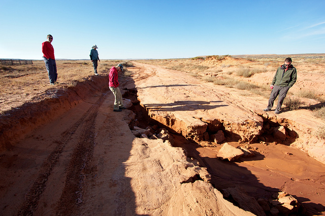
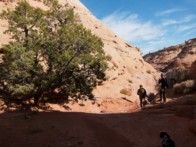
[/parsehtml]With the late night, I slept right through what looked like a really nice sunrise in camp. By 9:30 everyone was packed up and we were on our way to the trailhead for Little Blue John. The road was in pretty good conditions with the occasional 4WD section where a washout had occurred. But then we found this.
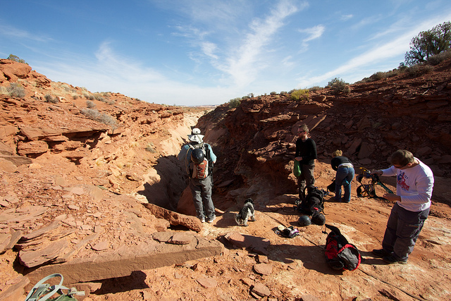
With some creativity, we made it past the obstacle and were on our way to the trailhead where we loaded up and set out. The hike down into Little Blue was pretty uneventful until the first obstacle. At first we thought this was the first rappel because of the webbing setup from a tree, just like the first rap was described. But soon we realized this was just the 30 foot down-climb. The Kauppila crew (including the pup) all down-climbed and the rest of us rapped. I definitely would not rap this one again. It looks kind of big at first but if you climb down into it, it is not difficult.
Austen rapping the down-climb.
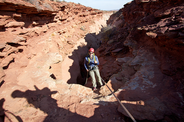
The next obstacle was a little trickier. It's a down-climb over a chokestone and in front of another chokestone. I would estimate 15-20 feet. Not very difficult but definitely a spot to pass packs down.
Soon after that we found ourselves at the first official rappel, roughly 80 feet long from a tree on the left. It takes quite a bit of webbing to set this up so come prepared in the event that it's no longer there or damaged/worn.
This first rappel goes straight into a very narrow and deep section of the canyon so getting decent photos from the top was pretty much impossible. Here's a shot of Nilauro shooting Tim on his descent.
And another of Tim near the bottom.
Soon after Tim, the dog was sent down. I thought they were going to put him in a backpack but they decided to lower him on webbing instead. It was hilarious to watch. It's a good thing they had a proper dog harness for him. To anyone thinking of critiquing me for taking a dog through a slot or lowering one off of an 80-foot cliff, save it, I was just along for the ride on this one.
The section between the two raps is beautiful and very narrow with a few little down-climbs and obstacles. There were a couple of spots with a bit of mud and water that were mostly avoidable. That's Austen (stemming) and Tim in between raps.
Nilauro stemming over one of the wet spots. As you can see, not much water.
The second rap was off of some webbing wrapped around a huge car-sized rock. It was pretty tough to inspect the webbing but fortunately there was another, newer piece around a smaller stone. It was tiny bit sketchy getting onto the rappel deck. There's only a small spot to stand between the huge boulder and the 80 foot drop. Having a method to clip into the anchor was really nice for the climb down to it and for getting your pack back on before getting on rope. I didn't really get a good shot here but this is Nilauro starting down the rappel. You can see how narrow it is where this drops down.
Once again, the dog was lowered with webbing but this time we had a snag. Near the bottom of the rap, the slot chokes up in the back. Dice decided he didn't like going down anymore and went into doggy-stemming mode and would not come down. Thor had to rap down and pick him up out of the crack.
Looking back up canyon towards the last rap in Little Blue John.
That was it for the technical portion of Little Blue John. From there it was a beautiful walk through long narrow section before reaching the main fork. I don't recall but it stayed narrow like this for quite a ways.
Main Fork Blue John Canyon just below the confluence with Little Blue John.
The canyon widens more and more as it continues towards the lower slot section where Aron Ralston incident occurred.
After what seemed like about 2 miles, we made it to the lower slot section and the famous 'S-Log'. I hate to admit it here on the inter webs, but I totally wussed out here. It's about a 15-foot drop down but not an easy climb back up and since we were no longer doing the through route, this would have to be negotiated in both directions. The immediate drop bells out and overhangs quite a bit so no chance of stemming up. The other option is to do a wide stem up to the S-Log and then follow the ledge on the right (or maybe left) back to the top. That was a bit exposed for my taste, particularly the last leap of faith that had to be done to get past the big hump you can see in the lower right of this shot.
So after much deliberation, I decided I would rather call this my turnaround point rather than figure out how to get my fat ass back up. I figured I'd be waiting a while but just minutes later Tim was already back at the drop off. The 'Ral-stone' was not far down canyon but it was wet and muddy beyond it. There would be no cheesy poses in front of the rock on this trip. Most of the group came back pretty quick and climbed back up. Here's a shot of Nick (not me) and Thor trying the various methods. It didn't seem too difficult to get to where Thor is (foreground) on the up climb but beyond that there was nothing to get a hold on.
Austen probably made it look the easiest out of everyone who climbed up the overhang.
As we hiked back up Blue John, we noticed a huge wall of dark clouds moving in. We weren't too worried about the flash flood potential at this point but we were worried about the sleeping bags left out in the open back in camp. So instead of our initial plan to hike up the West Fork, we opted for the West E/E exit because it looked faster on the map. It offered some great views but I think we probably took the wrong path somewhere along the way, the trail we were following was very lightly worn.
The little canyon right before we topped out. Dice was fun to watch in this section, he had issues picking the best path.
We made it back to camp with just minute before the sunset over the horizon. It's a damn good thing we didn't go for the full Ralston Route or we would have been hiking in head lamps.
I know I heard people say 'we need to do a group shot' at least a few times on this trip. We never did so I guess this shot I took around the campfire will have to do. Everyone's there, I am represented by my knees and Nilauro by his shoes on the left.
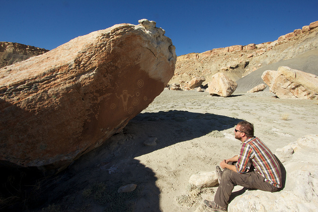
The next morning we made our way back to Green River. We stopped at the Chaffin Geyser to see if it might erupt but after 20-30 minutes we gave up. Next up was a stop in Black Dragon canyon just north of where I-70 cuts through the San Rafael Reef. I thought it was going to be a little hike to get to the rock art panel but it turned out to be something like 5 minutes.
The rock art was okay. Most of it was faded and traced in chalk by some modern douchebags. Fortunately there was something much more interesting that I had heard about. There is a huge cave in Black Dragon canyon that was formed when a deep alcove collapsed. The front of the alcove looks like nothing more than a huge pile of rocks and debris but if you climb to the top of it, there is a small opening where you can access the cave. Here's a little clip I made of some of my shots and a short video of the inside of the cave.
If you watched the video, you saw all of these shots but here's a few from inside the cave.
The light beam in the cave was a real treat. I'd like to go back a few weeks later in the year to see it at a lower angle. After Black Dragon we stopped at one more rock art site, The Juggler, and then it was home to Salt Lake.